InVEST model-based analysis of spatiotemporal evolution characteristics of habitat quality in the ecological green integrated demonstration area, Yangtze River Delta
ZHAO Qiang1(), WANG Tianjiu2(), WANG Tao3, CHENG Sudan4
1. Faculty of Environmental and Surveying Engineering, Suzhou University, Suzhou 234000, China 2. Kunyu Mountain Forest Farm, Yantai 264112, China 3. Shaoxing Natural Resources and Planning Bureau Shangyu Branch, Shaoxing 312300, China 4. Hangzhou Geotechnical Engineering & Surveying Research Institute Limited Company, Hangzhou 310012,China
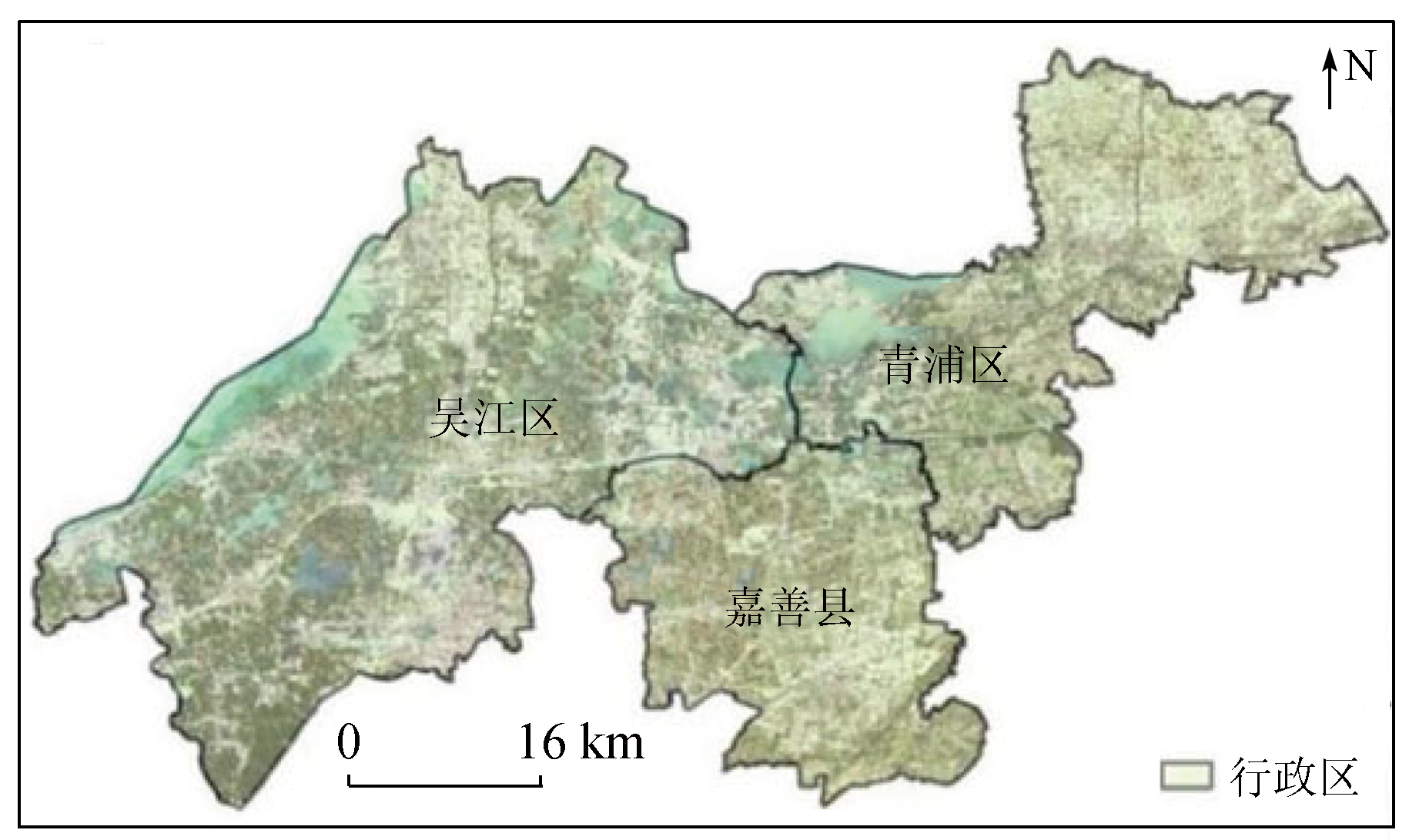
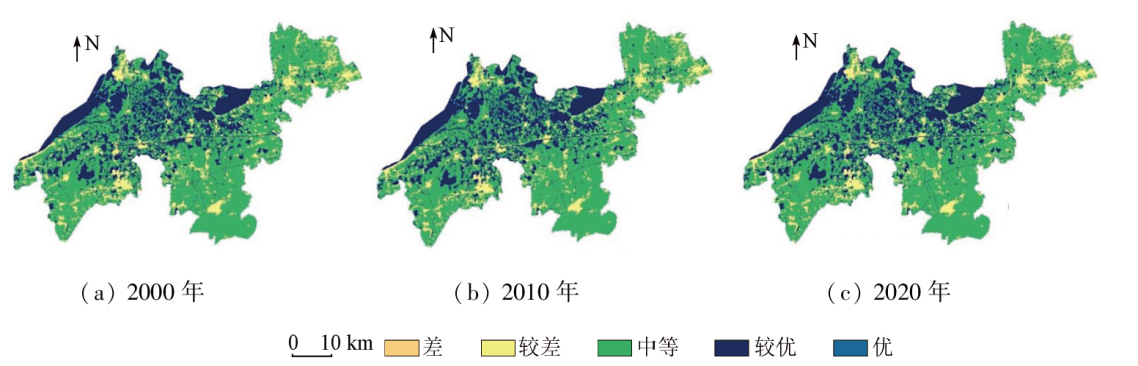
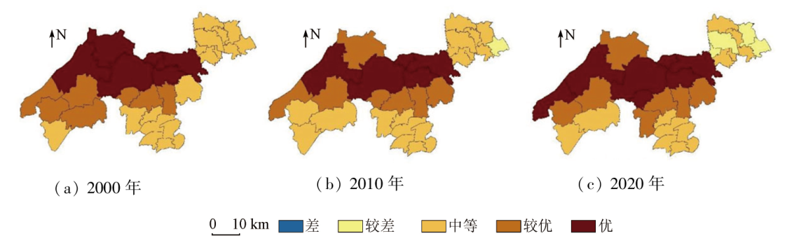
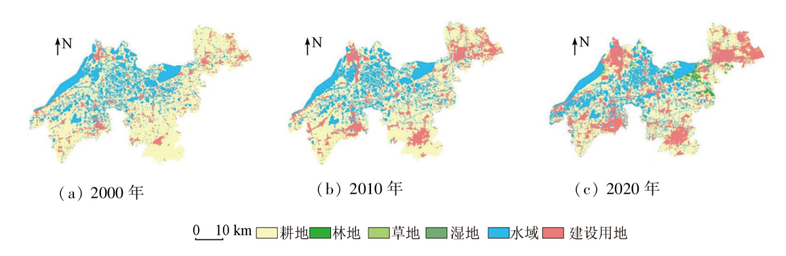
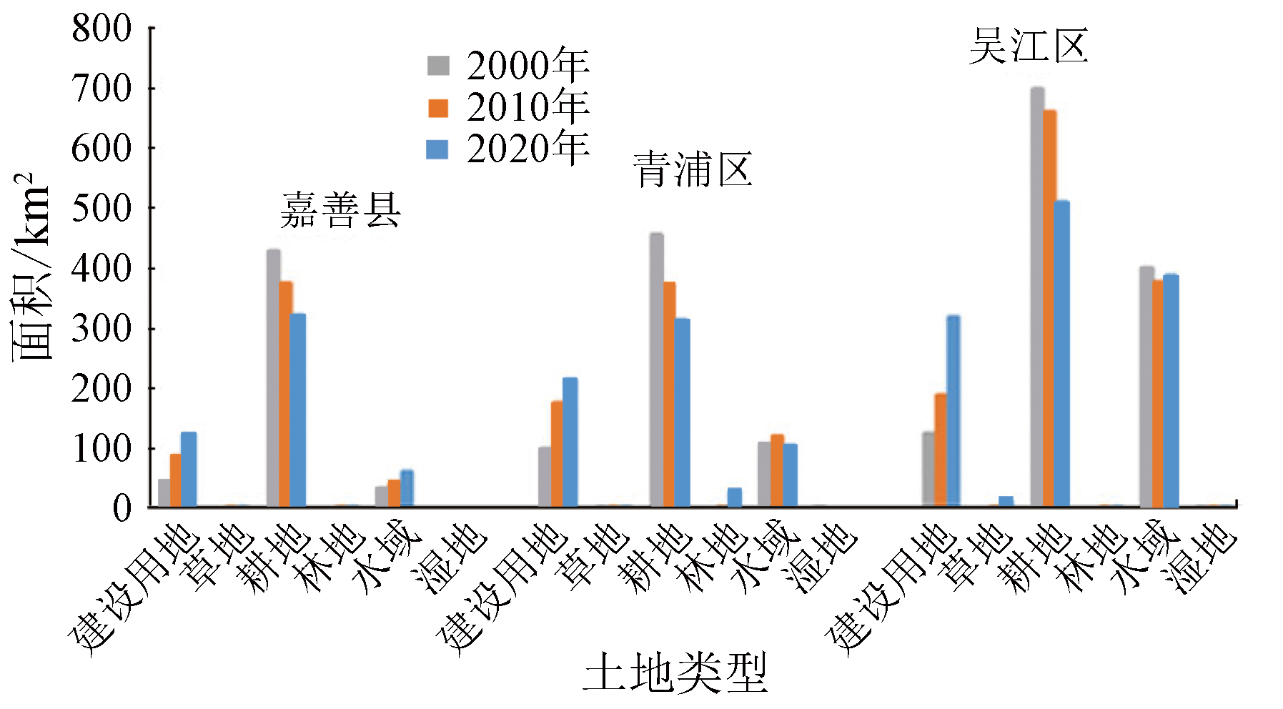
Assessing regional habitat quality holds great significance for maintaining regional biodiversity, enhancing human well-being, and achieving regional sustainable development. Based on the land use data of 2000, 2010, and 2020, this study analyzed the spatiotemporal characteristics of the habitat quality in the ecological green integrated demonstration area in the Yangtze River Delta using the InVEST model and the habitat quality index method. Furthermore, this study explored the relationship between regional habitat quality and land use. Key findings are as follows: ① From 2000 to 2020, the study area exhibited moderate habitat quality, with the habitat quality index trending downward and the habitat degradation gradually mitigating. Regarding the districts and counties in this area, Qingpu District of Shanghai, Wujiang District of Suzhou, Jiangsu, and Jiashan County of Jiaxing, Zhejiang (the two districts and one county) showed a downward trend in the habitat quality from 2000 to 2010. In contrast, from 2010 to 2020, Qingpu District and Jiashan County exhibited improved habitat quality, while Wujiang District still maintained a downward trend in the habitat quality; ② From 2000 to 2020, the study area primarily featured moderate habitat, with major land types including cultivated land and grassland. During this period, the water and wetland areas in the north and center, respectively exhibited the highest habitat quality, while the construction land in the study area displayed poor and inferior habitat; ③ There is a strong correlation between the habitat quality and land use structure in the study area. Specifically, areas with more intense changes in land use feature more significant variations in habitat quality. The results of this study will provide a reference for biodiversity conservation and land use management in the study area.
赵强, 王天鸠, 王涛, 程素丹. 基于InVEST模型的长三角生态绿色一体化示范区生境质量时空演变特征分析[J]. 自然资源遥感, 2024, 36(3): 187-195.
ZHAO Qiang, WANG Tianjiu, WANG Tao, CHENG Sudan. InVEST model-based analysis of spatiotemporal evolution characteristics of habitat quality in the ecological green integrated demonstration area, Yangtze River Delta. Remote Sensing for Natural Resources, 2024, 36(3): 187-195.
Xiao R L, Wang X Y, Gao J X. Analysis on the value of biodiversity and its relationship with human society[J]. Environmental Impact Assessment, 2022, 44(3):1-4.
Huang S Z. Information disclosure in the context of the sixth extinction:Analysis of the EU’s guidelines on biodiversity and ecosystem[J]. Finance and Accounting Monthly, 2022(14):3-11.
He Q Q, He J. Spatial and temporal evolution of habitat quality in the Three Gorges Reservoir Area(Chongqing section) based on InVEST model[J]. Ecology and Environmental Monitoring of Three Gorges, 2022, 7(1):15-25.
Cui D Y, Wang S D, Zhang X J. A remote sensing-based study on change in land use and vegetation cover in Xiong’an New Area from 1991 to 2021[J]. Remote Sensing for Natural Resources, 2023, 35(4):214-225.doi:10.6046/zrzyyg.2022311.
Pai R H, Zan M. Spatio-temporal changes and influencing factors of ecological environments in oasis cities of arid regions[J]. Remote Sensing for Natural Resources, 2023, 35(3):201-211.doi:10.6046/zrzyyg.2022194.
Gao Q Y, Pan Y J, Liu H. Spatial-temporal evolution of habitat quality in the Dali Bai Autonomous Prefecture based on the InVEST model[J]. Journal of Ecology and Rural Environment, 2021, 37(3):402-408.
Qu W, Xie B P, Chen Y, et al. Spatio-temporal patterns of habitat quality and habitat degradation and its terrain gradient effects of Yuzhong County based on InVEST model[J]. Journal of Gansu Agricultural University, 2022, 57(3):139-147.
[9]
Zhu C, Zhang X, Zhou M, et al. Impacts of urbanization and landscape pattern on habitat quality using OLS and GWR models in Hangzhou,China[J]. Ecological Indicators, 2020, 117:106654.
Sun H Y, Gong Q Q, Liu Q G, et al. Spatio-temporal evolution of habitat quality based on the land-use changes in Shandong Province[J]. Chinese Journal of Soil Science, 2022, 53(5):1019-1028.
Pan Y, Yin Y H, Hou W J, et al. Spatio temporal variation of habitat quality in the source region of the Yellow River based on land use and vegetation cover changes[J]. Acta Ecologica Sinica, 2022, 42(19):7978-7988.
Zhang J S, Gao M Y, Zhang Y S, et al. Impact of human disturbance on habitat quality and spatial optimization strategy in He’nan Yellow River Wetland National Nature Reserve[J]. Bulletin of Soil and Water Conservation, 2022, 42(5):140-150.
Lu Y Y, Li T X, Gong J Z. Attribution of habitat quality in different geomorphological types in Guangdong Province[J]. Ecological Science, 2022, 41(3):24-32.
Liu H Y, Lin M Z, Zhou R B, et al. Spatial and temporal evolution of habitat quality in Guangdong-Hong Kong-Macao Greater Bay Area based on InVEST model[J]. Ecological Science, 2021, 40(3):82-91.
Wu D, Li H, Ai N, et al. Predicting spatiotemporal changes in land use and habitat quality based on CA-Markov:A case study in central Ningxia,China[J]. Chinese Journal of Eco-Agriculture, 2020, 28(12):1969-1978.
[16]
Bender L, Roloff G, Haufler J. Evaluating confidence intervals for habitat suitability models[J]. Wildlife Society Bulletin, 1996, 24:347-352.
Liu Z S, Gao H, Teng L W, et al. Habitat suitability assessment of blue sheep in Helan Mountain based on MAXENT modeling[J]. Acta Ecologica Sinica, 2013, 33(22):7243-7249.
Qie G, Lin W P, Xu R J, et al. Calculation and analysis of SDG 15.1.2 biodiversity index based on remote sensing:A case study of demonstration zone of green and integrated ecological development of the Yangtze River Delta[J]. Research of Environmental Sciences, 2022, 35(4):1025-1036.
Li L B. Ecological risk assessment of Yangtze River Delta urban agglomeration based on ecosystem service value[D]. Shanghai: Shanghai Normal University, 2022.
Liu Y Y, Zeng P, Zhang R, et al. Vegetation coverage change of the demonstration area of ecologically friendly development in the Yangtze River Delta,China based on GEE and BRT during 1984—2019[J]. Chinese Journal of Applied Ecology, 2021, 32(3):1033-1044.
He T X, Tian N, Zhou R, et al. Dynamic assessment of eco-environmental quality in Yangtze River Delta integration demonstration area based on GEE and RSEI[J]. Chinese Journal of Ecology, 2023, 42(2):436-444.
Zhang H, Han W H, Song J Y, et al. Spatial-temporal variations of habitat quality in Qilian Mountain National Park[J]. Chinese Journal of Ecology, 2021, 40(5):1419-1430.
Fu C, Wang L Z, Deng J P, et al. An analysis of the characteristics of habitat quality change in Poyang Lake basin by different influencing factors[J]. China Rural Water and Hydropower, 2021(11):1-8,23.
Chang Y Y, Gao Y, Xie Z, et al. Spatiotemporal evolution and spatial correlation of habitat quality and landscape pattern over Beijing-Tianjin-Hebei Region[J]. China Environmental Science, 2021, 41(2):848-859.
Cao R C. Research on the evolution of the evolution of the quality of life and space based on the InVEST model[J]. Agriculture and Technology, 2021, 41(18):104-107.
 2024, Vol. 36
  ), 王天鸠2(