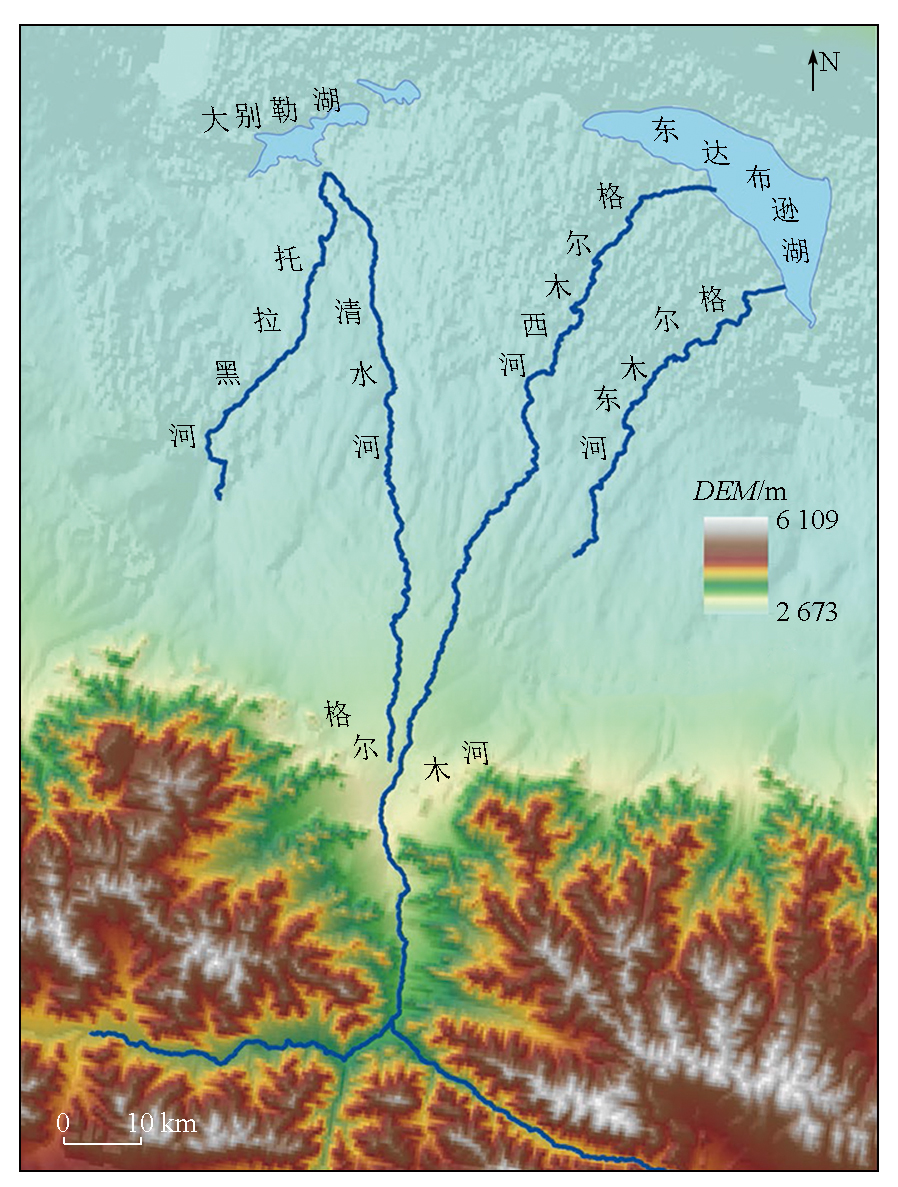
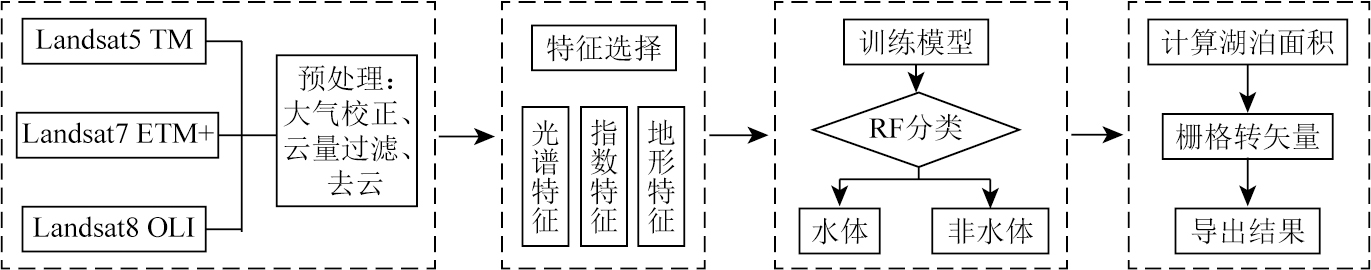
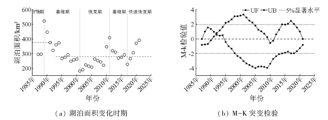
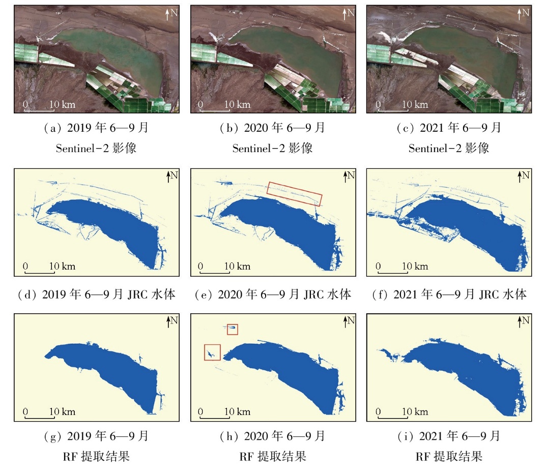
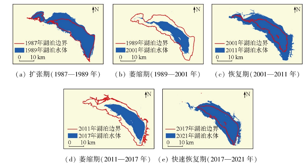
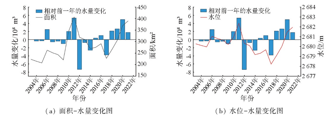
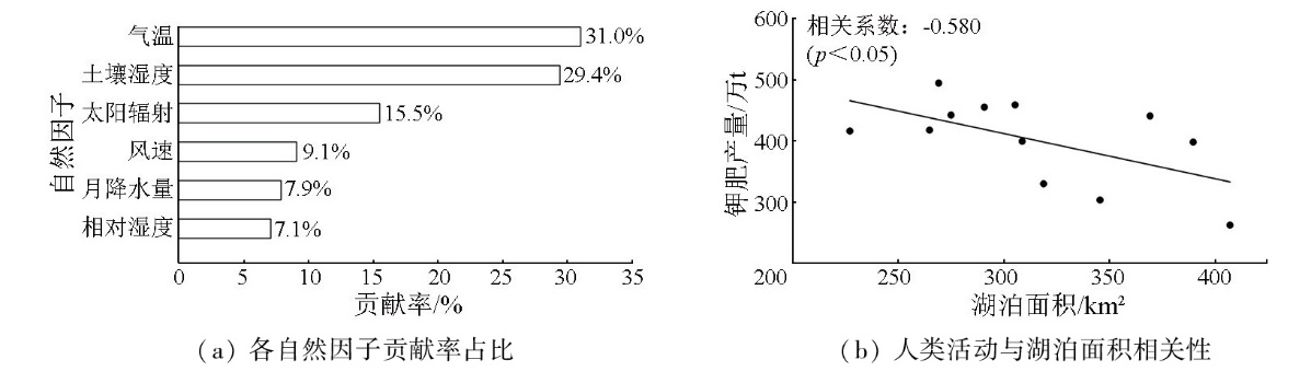
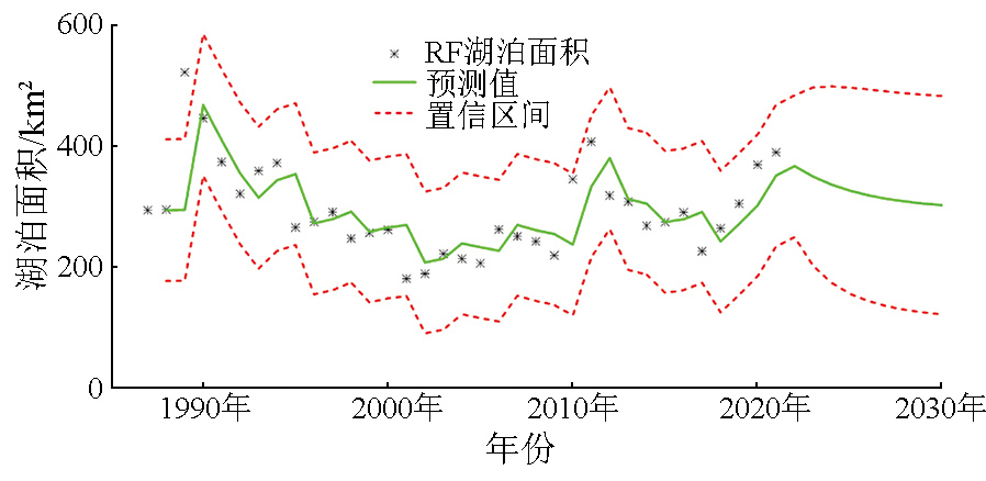
Changes in lake area and water volume exert significant impacts on the ecological environment of arid regions. Targeting East Dabuxun Lake,Golmud River Basin,Qinghai Province,this study developed a multi-index random forest algorithm based on the Google Earth Engine (GEE) cloud platform and Landsat imagery to extract the lake area from 1987 to 2021. Then,an area-water level relationship was established using laser altimetry data from ICESat and CryoSat satellites to estimate changes in water volume. Finally,the impacts of natural factors and human activities on the lake were evaluated,using ERA5-Land climate data and records of potash mining,along with correlation analysis and random forest-based contribution assessment. The results indicate that the temporal changes in lake area over time can be divided into five stages:expansion,shrinkage,recovery,re-shrinkage,and rapid recovery. Spatially,the lake exhibited a pattern of shrinkage in the south and expansion towards the northwest. From 2003 to 2021,the water volume of East Dabuxun Lake showed an upward trend. Temperature,glacier and permafrost melting,and solar radiation were identified as the main natural factors influencing lake area,with contribution rates of 31.0%,29.4%,and 15.5%,respectively. In terms of human activities,potash mining emerged as a major driver of lake area changes after 2010. Based on predictions by the auto-regressive moving average model (ARIMA),the lake area is projected to decline to 302.78 km2 by 2030.
周玉静, 金晓媚, 马靖宣, 李晴. 青海东达布逊湖湖泊面积和水量的变化研究[J]. 自然资源遥感, 2025, 37(5): 15-23.
ZHOU Yujing, JIN Xiaomei, MA Jingxuan, LI Qing. Variations in area and water volume of East Dabuxun Lake,Qinghai Province. Remote Sensing for Natural Resources, 2025, 37(5): 15-23.
Li D, Wu B S, Chen B W, et al. Review of water body information extraction based on satellite remote sensing[J]. Journal of Tsinghua University (Science and Technology), 2020, 60(2):147-161.
[3]
Wang D, Huo Z L, Miao P, et al. Comparison of machine learning models to predict lake area in an arid area[J]. Remote Sensing, 2023, 15(17):4153.
[4]
Xia H M, Zhao J Y, Qin Y C, et al. Changes in water surface area during 1989—2017 in the Huai River Basin using landsat data and Google Earth Engine[J]. Remote Sensing, 2019, 11(15):1824.
Xu H Q. Development of remote sensing water indices:A review[J]. Journal of Fuzhou University (Natural Science Edition), 2021, 49(5):613-625.
[6]
Zhou Y, Dong J W, Xiao X M, et al. Continuous monitoring of lake dynamics on the Mongolian Plateau using all available Landsat imagery and Google Earth Engine[J]. Science of the Total Environment, 2019, 689:366-380.
doi: 10.1016/j.scitotenv.2019.06.341
[7]
Li X S, Zhang D H, Jiang C C, et al. Comparison of lake area extraction algorithms in Qinghai Tibet Plateau leveraging Google Earth Engine and Landsat-9 data[J]. Remote Sensing, 2022, 14(18):4612.
[8]
Yang Y P, Yang D, Wang X F, et al. Testing accuracy of land cover classification algorithms in the Qilian Mountains based on GEE cloud platform[J]. Remote Sensing, 2021, 13(24):5064.
[9]
Rao P Z, Jiang W G, Hou Y K, et al. Dynamic change analysis of surface water in the Yangtze River Basin based on MODIS products[J]. Remote Sensing, 2018, 10(7):1025.
[10]
Liu C, Hu R H, Wang Y F, et al. Monitoring water level and volume changes of lakes and reservoirs in the Yellow River Basin using ICESat-2 laser altimetry and Google Earth Engine[J]. Journal of Hydro-Environment Research, 2022, 44:53-64.
Zhang G Q, Wang M M, Zhou T, et al. Progress in remote sensing monitoring of lake area,water level,and volume changes on the Tibetan Plateau[J]. National Remote Sensing Bulletin, 2022, 26(1):115-125.
Ma S M, Gan F P, Wu H C, et al. ICESat-2 data-based monitoring of 2018—2021 variations in the water levels of lakes in the Qinghai-Tibet Plateau[J]. Remote Sensing for Natural Resources, 2022, 34(3):164-172.doi:10.6046/zrzyyg.2021329.
Tian H, Wei C, Ning S X, et al. Study on the change of area of Dabson Lake and its influencing factors[J]. Henan Science and Technology, 2018(29):89-91.
Yang X H, Xu X, Xiao L X, et al. Evolution trend and driving force analysis of the Chaerhan Salt Lake[J]. Remote Sensing for Land and Resources, 2020, 32(1):130-137.doi:10.6046/gtzyyg.2020.01.18.
Wang Y, Liu S, Qiu L S, et al. A dataset of the annual water bodies in wet seasons on the Mongolian Plateau during 1990—2021[J]. China Scientific Data, 2023, 8(1):69-82.
Wang J C, Li Y, Shi K, et al. Long-term spatiotemporal variation in water area of the Xin’anjiang Reservoir(Lake Qiandao)from 1987 to 2022 and its relationships with water level and water storage[J]. Journal of Lake Sciences, 2024, 36(3):913-926.
[20]
Pal M. Random forest classifier for remote sensing classification[J]. International Journal of Remote Sensing, 2005, 26(1):217-222.
Chen M J, Wang X Q, Wu S Y. Importance analysis of soil erosion influencing factors based on random forest[J]. Journal of Natural Disasters, 2019, 28(4):209-219.
Xu H Q. A study on information extraction of water body with the modified normalized difference water index (MNDWI)[J]. Journal of Remote Sensing, 2005, 9(5):589-595.
[23]
Liu H Q, Huete A. A feedback based modification of the NDVI to minimize canopy background and atmospheric noise[J]. IEEE Transactions on Geoscience and Remote Sensing, 1995, 33(2):457-465.
[24]
Li K N, Chen Y H. A genetic algorithm-based urban cluster automatic threshold method by combining VIIRS DNB,NDVI,and NDBI to monitor urbanization[J]. Remote Sensing, 2018, 10(2):277.
[25]
Bhang K J, Schwartz F W, Braun A. Verification of the vertical error in C-band SRTM DEM using ICESat and Landsat-7,otter tail county,MN[J]. IEEE Transactions on Geoscience and Remote Sensing, 2007, 45(1):36-44.
Ma J X, Jin X M, Zhang X C, et al. Spatio-temporal change characteristics of water conservation function in the Zhang-Cheng district based on the InVEST model[J]. Hydrogeology & Engineering Geology, 2023, 50(3):54-64.
Liu Z L, Ding Y P, Jiao Y M, et al. Spatiotemporal variation of impervious surface and abnormal climate phenomenon in central Yunnan Urban Agglomeration[J]. Acta Geographica Sinica, 2022, 77(7):1775-1793.
doi: 10.11821/dlxb202207014
Wang P F, Guo Y Y, Zhou K, et al. Variation of lake area of Hulun Lake during 1961—2018 and its response to climate change[J]. Research of Environmental Sciences, 2021, 34(4):792-800.
Chen J, Liu Y Z, Cao L G, et al. A review on the research of remote sensing monitoring of lake changes and quantitative estimation of lake water balance in Qinghai-Tibet Plateau[J]. Journal of Glaciology and Geocryology, 2022, 44(4):1203-1215.
doi: 10.7522/j.issn.1000-0240.2022.0110
Wei S R, Jin X M, Wang K L, et al. Response of lake area variation to climate change in Qaidam Basin based on remote sensing[J]. Earth Science Frontiers, 2017, 24(5):427-433.
Du Y E, Liu B K, He W G, et al. Analysis on the variation and cause of the lake area in Qaidam Basin from 1976 to 2017[J]. Journal of Glaciology and Geocryology, 2018, 40(6):1275-1284.
doi: 10.7522/j.issn.1000-0240.2019.0304
 2025, Vol. 37
  ), 金晓媚(