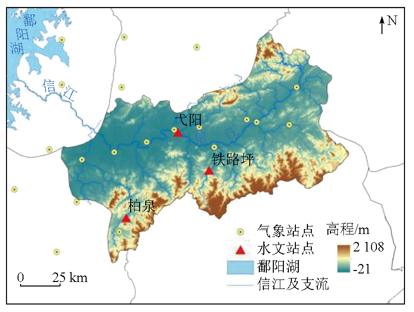
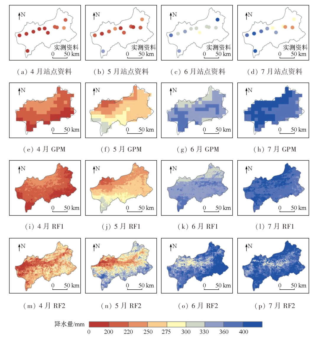
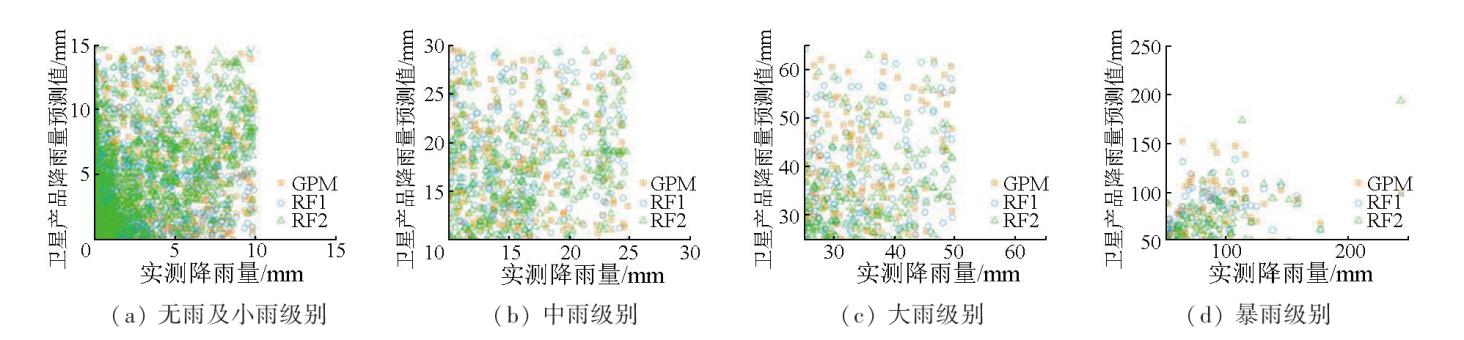
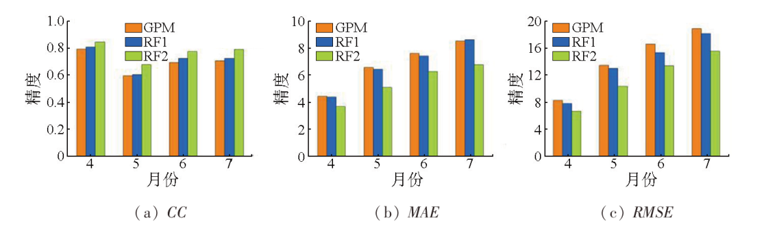
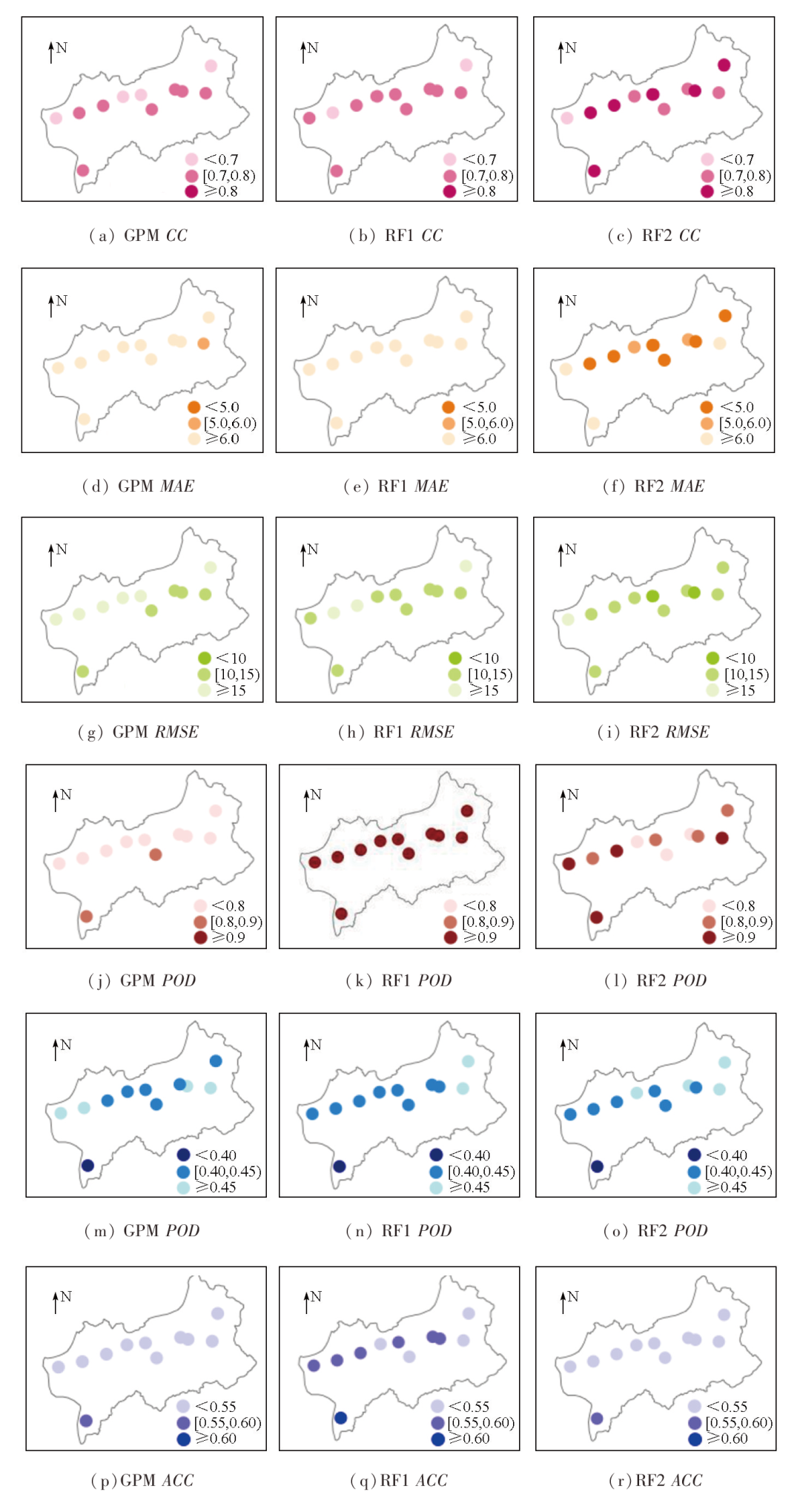
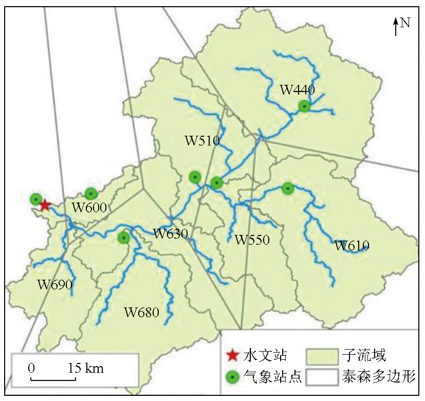
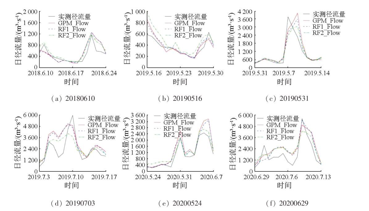
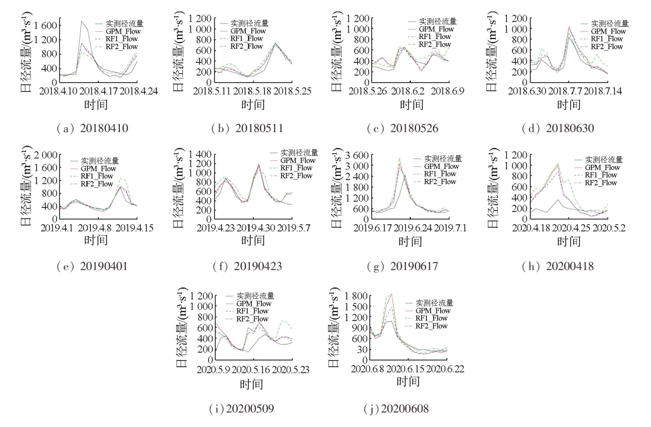
Precipitation products, including the Global Precipitation Measurement (GPM) mission, have been widely used in river basin studies due to their advantages like continuous distributions and broad spatial ranges. However, they are limited by insufficient accuracy and low spatial resolution. Based on the random forest (RF), this study integrated multisource influencing factors to generate two daily precipitation products with high spatial resolution: RF1 and RF2. The two daily precipitation products were input to the Hydrologic Engineering Center’s Hydrologic Modeling System (HEC-HMS) model to simulate daily runoff changes in the Xinjiang River basin. Finally, this study assessed the contributions of RF1 and RF2 to the improvement of GPM’s hydrologic applicability. The results show that both RF1 and RF2 improved the accuracy and distribution details of GPM data. RF2 exhibited a higher correlation and lower error, whereas RF1 manifested superior performance in detecting precipitation events. The RF1-simulated runoff curves resembled GPM-derived curves, showing significant improvements. RF2 corrected partial GPM’s overestimates and more accurately revealed the peak values of real flow curves in some periods. However, the uneven distribution of monitoring stations affected RF2’s prediction in complex terrain areas, limiting its simulation accuracy. Overall, both RF1 and RF2 can effectively reflect daily precipitation changes in the Xinjiang River basin, improving GPM’s hydrologic applicability to varying degrees.
陈多妍, 史岚. 基于随机森林的降水产品降尺度及其水文适用性评估[J]. 自然资源遥感, 2025, 37(2): 66-79.
CHEN Duoyan, SHI Lan. Downscaling of precipitation products based on the random forest and assessment of their hydrologic applicability. Remote Sensing for Natural Resources, 2025, 37(2): 66-79.
Li Y Y, Ning S W, Ding W, et al. The evaluation of latest GPM-Era precipitation data in Yellow River basin[J]. Remote Sensing for Land and Resources, 2019, 31(1):164-170.doi:10.6046/gtzyyg/2019.01.22.
[2]
Mohammed I N, Bolten J D, Srinivasan R, et al. Improved hydrological decision support system for the lower Mekong River Basin using satellite-based earth observations[J]. Remote Sensing, 2018, 10(6):885.
doi: 10.3390/rs10060885
pmid: 29938116
Liu J, Sun Z L, Zhang T, et al. Hydrological evaluations of runoff simulations based on multiple satellite precipitation products over the Huayuan catchment[J]. Resources and Environment in the Yangtze Basin, 2018, 27(11):2558-2567.
Wang S X, Zhang L P, Yu X Y, et al. Application of remote sensing precipitation products in runoff simulation over the Lancang River Basin[J]. Resources and Environment in the Yangtze Basin, 2019, 28(6):1365-1374.
Cai L J. Research on the applicability of satellite precipitation products based on VIC model in Ganjiang basin[D]. Nanning: Nanning Normal University, 2021.
[6]
Ji H Y, Peng D Z, Gu Y, et al. Evaluation of multiple satellite precipitation products and their potential utilities in the Yarlung Zangbo River Basin[J]. Scientific Reports, 2022, 12:13334.
doi: 10.1038/s41598-022-17551-y
pmid: 35922539
[7]
Lyu A F, Qi S S, Wang G S. Multi-model driven by diverse precipitation datasets increases confidence in identifying dominant factors for runoff change in a subbasin of the Qaidam Basin of China[J]. Science of the Total Environment, 2022, 802:149831.
Sun H, Su F G. Evaluation of multiple precipitation datasets and their potential utilities in hydrologic modeling over the Yarlung Zangbo River Basin[J]. Progress in Geography, 2020, 39(7):1126-1139.
doi: 10.18306/dlkxjz.2020.07.006
Fan H X, He H D, Xu L G, et al. Simulation and attribution analysis based on the long-short-term-memory network for detecting the dominant cause of runoff variation in the Lake Poyang Basin[J]. Journal of Lake Sciences, 2021, 33(3) :866-878.
Zhang F, Zhang Y Y, Chen J X, et al. Performance of multiple machine learning model simulation of process characteristic indicators of different flood types[J]. Progress in Geography, 2022, 41(7):1239-1250.
doi: 10.18306/dlkxjz.2022.07.008
Fan T Y, Zhang X, Huang B, et al. Downscaling of TRMM precipitation products and its application in Xiangjiang River Basin[J]. Remote Sensing for Natural Resources, 2021, 33(4):209-218.doi:10.6046/zrzyyg.2020395.
Du Y, Wang D Y, Wang D G. Spatial downscaling of GPM precipitation products:A case study of Guizhou Province[J]. Remote Sensing for Natural Resources, 2021, 33(4):111-120.doi:10.6046/zrzyyg.2021009.
[13]
Ma Z, Tan X, Yang Y, et al. The first comparisons of IMERG and the downscaled results based on IMERG in hydrological utility over the Ganjiang River Basin[J]. Water, 2018, 10(10):1392.
Min X Y, Yang C G, Li Y, et al. Accuracy analysis of flood forecasting based on the fusion data of satellite and guage rainfalls in humid region[J]. Water Resources and Power, 2020, 38(4):1-5.
Tian J, Guo S L, Liu D D, et al. Impacts of climate and land use/cover changes on runoff in the Hanjiang River basin[J]. Acta Geographica Sinica, 2020, 75(11):2307-2318.
doi: 10.11821/dlxb202011003
Sun G K, Wei Y X, Wang Y F, et al. Fusion Calibration of precipitation data by IMERG satellite and its hydrological applicability[J]. Water Resources and Power, 2021, 39(11):23-26.
[17]
Zhao Y M, Xu K, Dong N P, et al. Optimally integrating multi-source products for improving long series precipitation precision by using machine learning methods[J]. Journal of Hydrology, 2022, 609:127707.
[18]
Cheng X, Ma X X, Wang W S, et al. Application of HEC-HMS parameter regionalization in small watershed of hilly area[J]. Water Resources Management, 2021, 35(6):1961-1976.
[19]
Fanta S S, Sime C H. Performance assessment of SWAT and HEC-HMS model for runoff simulation of Toba watershed,Ethiopia[J]. Sustainable Water Resources Management, 2022, 8(1):1-16.
Liao R T, Hu S S, Du L G, et al. Hydrological simulation of Wenyu River Basin based on HEC-HMS model[J]. South-to-North Water Transfers and Water Science and Technology, 2018, 16(6):15-20.
[21]
Fang L, Huang J L, Cai J T, et al. Hybrid approach for flood susceptibility assessment in a flood-prone mountainous catchment in China[J]. Journal of Hydrology, 2022, 612:128091.
Li X H, Zhang Q, Shao M. Spatio-temporal distribution of precipitation in Poyang Lake basin based on TRMM data and precision evaluation[J]. Progress in Geography, 2012, 31(9):1164-1170.
doi: 10.11820/dlkxjz.2012.09.007
Zeng B R, Li Y L, Tan Z Q. Influential factors and environmental effects of hydrological connectivity in the Poyang Lake catchment[J]. Resources and Environment in the Yangtze Basin, 2022, 31(12):2718-2728.
Tian Z H, Yin C X, Wang X L. Dynamic monitoring and driving factors analysis of ecological environment quality in Poyang Lake basin[J]. Environmental Science, 2023, 44(2):816-827.
Xu X L. Monthly vegetation index spatial distribution dataset of China[EB/OL]. Geographic Remote Sensing Ecological Network Platform(www.gisrs.cn), 2018.
[26]
Didan K. MODIS/Terra Vegetation Indices Monthly L3 Global 1km SIN Grid V006[EB/OL]. NASA EOSDIS Land Processes DAAC, 2015.
Ou L J, Yu J H, Zhong X Y, et al. Impacts of the SST warming trend and natural variability on the summer extreme precipitation intensity of the middle and lower reaches of the Yangtze River[J]. Chinese Journal of Atmospheric Sciences, 2022, 46(6):1595-1606.
Chen Y, Wang A H, Zhi R, et al. Contributions of large-scale circulation and local land-atmosphere interaction to precipitation in eastern China:Investigation on influencing factors of the July 2021 heavy precipitation event in Henan Province[J]. Chinese Journal of Atmospheric Sciences, 2023, 47(2):551-566.
Pan F, He D M, Cao J, et al. Multiple branches of water vapor transport over the Nujiang River Basin in summer and its impact on precipitation[J]. Acta Geographica Sinica, 2023, 78(1):87-100.
doi: 10.11821/dlxb202301006
[30]
Arfanad A, Zhang W C, Zhang Z J, et al. Reconstructing high-resolution gridded precipitation data using an improved downscaling approach over the high altitude mountain regions of Upper Indus basin (UIB)[J]. Science of the Total Environment, 2021, 784:147140.
Li X T, Shi L, Chen D Y. Research on downscaling of GPM precipitation products based on deep learning in Fujian-Zhejiang-Jiangxi[J]. Remote Sensing for Natural Resources, 2023, 35(4):105-113.doi:10.6046/zrzyyg.2022270.
Xue Z X, Zhang L, Wang X J, et al. Downscaling analysis of SMAP soil moisture products in Gurbantunggut Desert[J]. Arid Zone Research, 2023, 40(4):583-593.
doi: 10.13866/j.azr.2023.04.07
Guo Y Z, Li X H. Spatiotemporal changes of urban construction land structure and driving mechanism in the Yellow River Basin based on random forest model[J]. Progress in Geography, 2023, 42(1):12-26.
doi: 10.18306/dlkxjz.2023.01.002
Li N N, Wu H, Luan Q Z. Land surface temperature downscaling in urban area:A case study of Beijing[J]. National Remote Sensing Bulletin, 2021, 25(8):1808-1820.
Zeng S K, Yong B. Evaluation of the GPM-based IMERG and GSMaP precipitation estimates over the Sichuan region[J]. Acta Geographica Sinica, 2019, 74(7):1305-1318.
doi: 10.11821/dlxb201907003
Peng Z H, Li Y Z, Yu W J, et al. Research on the applicability of remote sensing precipitation products in different climatic regions of China[J]. Journal of Geo-Information Science, 2021, 23(7):1296-1311.
[37]
曹旖丹. 气候变化下长白山二道松花江流域降雨径流模拟及预测[D]. 长春: 吉林大学, 2021.
Cao Y D. Simulation and prediction of rainfall and runoff in the Erdao Songhua River basin of Changbai Mountain under climate change[D]. Changchun: Jilin University, 2021.
Yuan W L, Fu L, Gao Q Y. Research on rainfall threshold of flash flood based on HEC-HMS model[J]. Yellow River, 2019, 41(8):22-27,31.
[39]
Belay Y Y, Gouday Y A, Alemnew H N. Comparison of HEC-HMS hydrologic model for estimation of runoff computation techniques as a design input:Case of Middle Awash multi-purpose dam,Ethiopia[J]. Applied Water Science, 2022, 12(10):237.
Zhang L P, Qin G H, Yang L L, et al. Evaluation of the IMERG and GSMaP precipitation products over Minjiang Watershed[J]. Journal of China Hydrology, 2022, 42(6):93-98.
 2025, Vol. 37
  ), 史岚(