GIS-based analysis of dynamic changes and driving forces for natural lakes in Anhui Province
HE Weirong1,2(), HUO Runbin1,2, LI Donghui1, ZHANG Fengshan1, WANG Xinfeng1,2()
1. Langfang Integrated Natural Resources Survey Center,China Geological Survey,Langfang 065000,China 2. Technical Innovation Base for Natural Resources Monitoring in the Lower Reaches of Yongding River Area,ChinaGeological Society,Langfang 065000,China
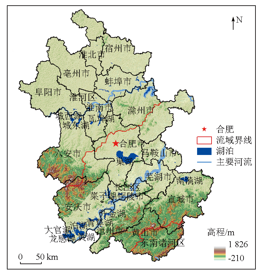
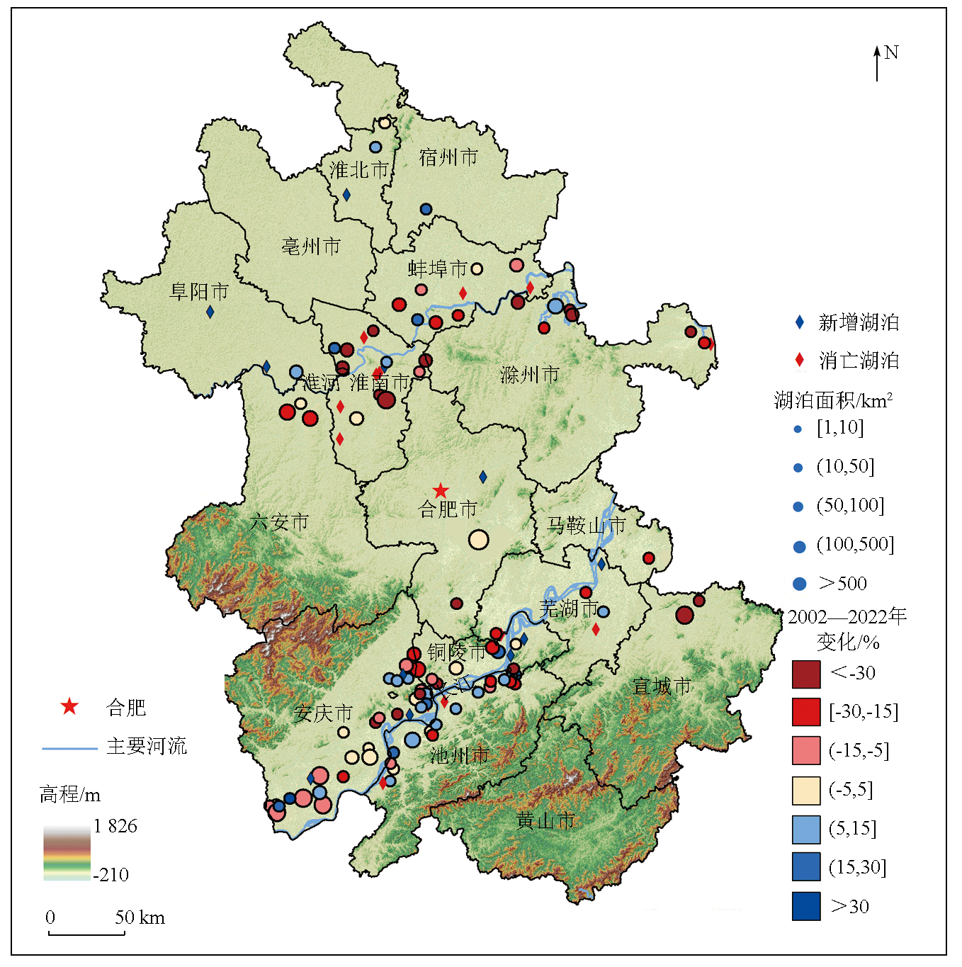
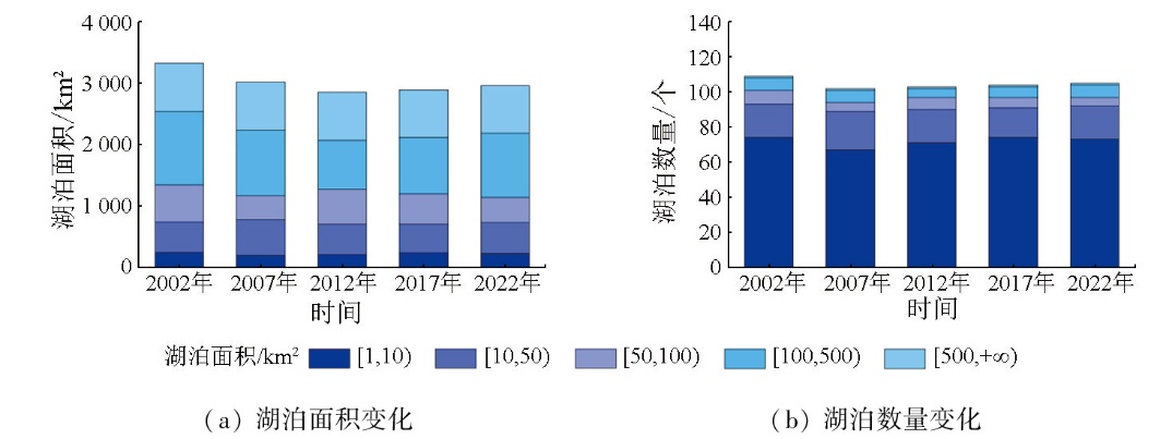
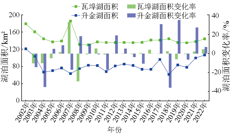
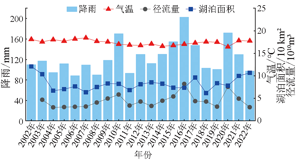
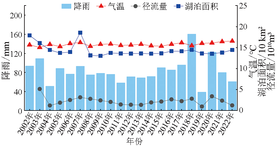
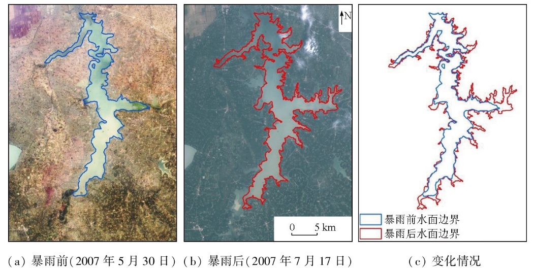
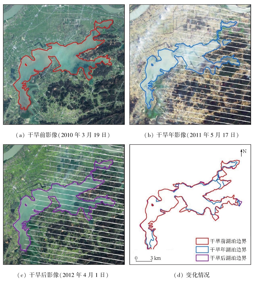
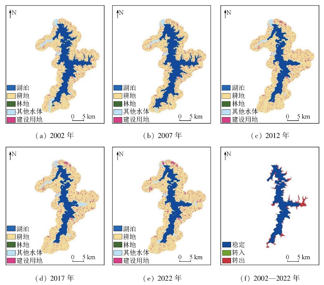
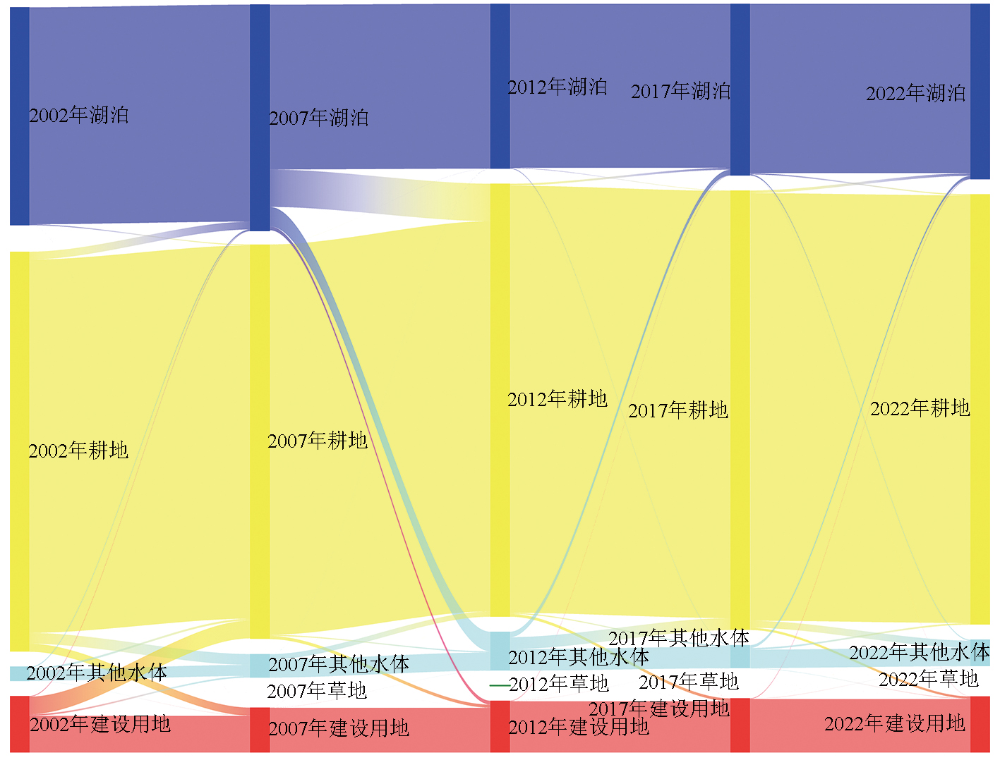
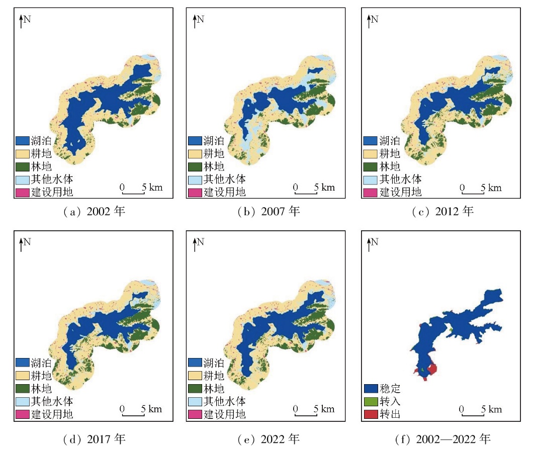
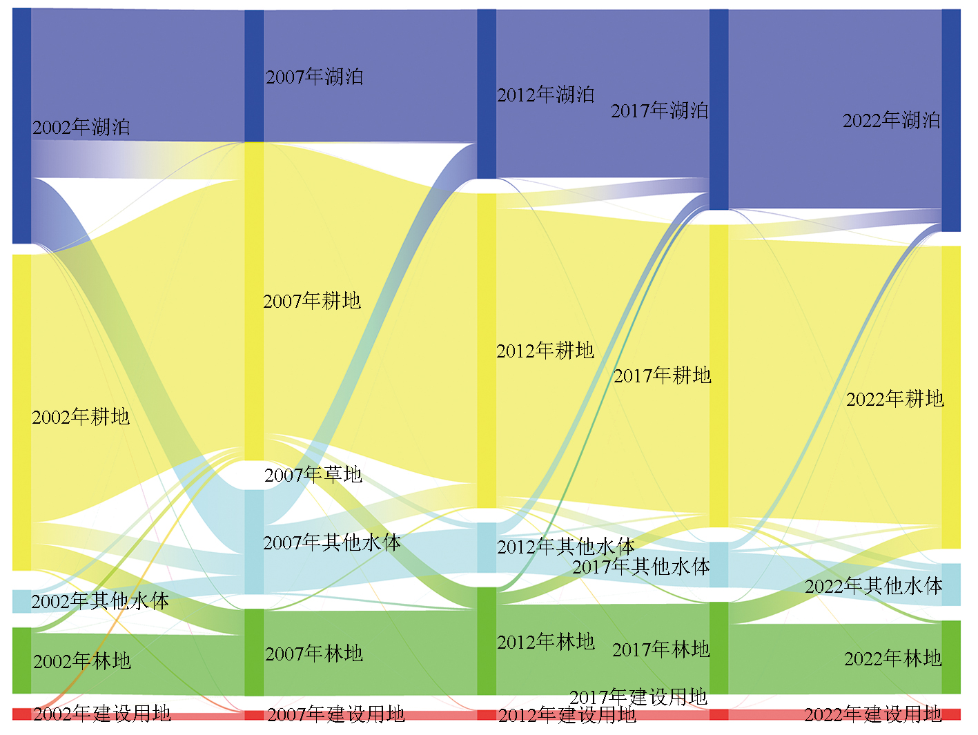
Natural lakes,as a precious natural resource in Anhui Province,are defined as large water bodies formed by natural water accumulation in surface depressions. Different from artificial water bodies such as reservoirs and ponds,they are formed and evolved under the control of geological,climatic,and hydrological conditions. Moreover,characterized by relatively stable forms and ecosystems,they play important roles in regional ecological balance,economic development,and socio-cultural activities. Therefore,investigating their spatiotemporal changes and driving forces is highly significant for the protection of natural lakes in Anhui Province. This study collected data from the Thematic Mapper (TM) onboard the Landsat-5 satellite and the Operational Land Imager onboard the Landsat-8 satellite. Then,the natural lakes in Anhui Province were extracted from these data using a human-computer interaction method. This study investigated spatiotemporal changes of the lakes using the dynamic degree and land use transfer matrix. The driving factors of the changes were examined from two aspects:natural factors and social factors. From 2002 to 2022,the natural lakes in Anhui Province showed a phased change in both area and number,characterized by an initial decrease followed by an increase. In terms of lake area,the total area of the lakes decreased by 366.5 km2. Specifically,from 2002 to 2012,the lake area decreased rapidly,reaching its lowest value of 2850.12 km2 in 2012. From 2012 to 2022,the area gradually recovered,rebounding to 2960.97 km2 in 2022. In terms of the lake number,there was a cumulative reduction of four lakes over the period. Specifically,the period from 2002 to 2007 saw a rapid decline,with an average annual decrease of 1.4 lakes. From 2007 to 2022,the number gradually rebounded,with an average annual increase of 0.2 lakes,reaching a total of 105 lakes in 2022. The changes in land use around typical lakes predominantly involved the conversion to arable land and other water bodies. In Anhui Province,the natural lake areas were influenced by both natural and social factors. The decreased runoff of the Huaihe River resulted in a decrease in inflow into the lakes,which serves as a key natural factor contributing to the reduction of the natural lake area in Anhui Province. Human activities and land use changes around the lakes are identified as important social factors for the reduction of the lake area.
何威荣, 霍润斌, 李东辉, 张峰山, 王新峰. 基于GIS的安徽省自然湖泊动态变化及驱动力分析[J]. 自然资源遥感, 2025, 37(5): 32-43.
HE Weirong, HUO Runbin, LI Donghui, ZHANG Fengshan, WANG Xinfeng. GIS-based analysis of dynamic changes and driving forces for natural lakes in Anhui Province. Remote Sensing for Natural Resources, 2025, 37(5): 32-43.
Zhang W S, Song C Q. Spatial distribution and dynamics of lakes in China:Progress in remote sensing monitoring at national scale and new inventory of the maximum lake extent and change trajectory[J]. National Remote Sensing Bulletin, 2022, 26(1):92-103.
Liu J F, Wu H H, Song W. Existing state and evolvement analysis of the Chinese Lake water resources[J]. Journal of Yellow River Conservancy Technical Institute, 2008, 20(1):1-4.
[6]
祁家禹. 安徽省水资源现状及保护利用对策[J]. 现代农业科技, 2011(21):273.
Qi J Y. Present situation of water resources in Anhui Province and its protection and utilization countermeasures[J]. Modern Agricultural Science and Technology, 2011(21):273.
Song H M, Wang Z N, Gu W. Discussion on the lake protection planning in Huaihe River basin of Anhui Province[J]. Water Resources Development and Management, 2021, 7(7):41-43,32.
[8]
Yao F, Livneh B, Rajagopalan B, et al. Satellites reveal widespread decline in global lake water storage[J]. Science, 2023, 380(6646):743-749.
doi: 10.1126/science.abo2812
pmid: 37200445
[9]
Xu N, Lu H, Li W, et al. Natural lakes dominate global water sto-rage variability[J]. Science Bulletin, 2024, 69(8):1016-1019.
[10]
Jane S F, Hansen G J A, Kraemer B M, et al. Widespread deoxygenation of temperate lakes[J]. Nature, 2021, 594(7861):66-70.
[11]
Wang X, Shi K, Qin B, et al. Disproportionate impact of atmosphe-ric heat events on lake surface water temperature increases[J]. Nature Climate Change, 2024, 14(11):1172-1177.
Bai J, Chen X, Li J L, et al. Changes of inland lake area in arid Central Asia during 1975—2007:A remote-sensing analysis[J]. Journal of Lake Sciences, 2011, 23(1):80-88.
Wang Y H. Study on the area change of major lakes in China based on satellite remote sensing images in recent 30 years[D]. Kunming: Yunnan Normal University, 2022.
[14]
Wu J, Ke C Q, Cai Y, et al. Monitoring multi-temporal changes of lakes on the Tibetan Plateau using multi-source remote sensing data from 1992 to 2019:A case study of lake zhari namco[J]. Journal of Earth Science, 2024, 35(5):1679-1691.
Duan J B, Peng P, Yang D K. Remote sensing image-based analysis on the change of wetland of Anqing city along the Yangtze River and the driving force over the past 50 years[J]. Geology of Anhui, 2021, 31(4):352-357.
[16]
王春霞. 基于遥感影像的云贵高原湖泊提取及动态变化分析[D]. 贵阳: 贵州大学, 2022.
Wang C X. Extraction and dynamic change analysis of lakes in Yunnan-Guizhou Plateau based on remote sensing images[D]. Guiyang: Guizhou University, 2022.
Li N, Liu J P, Wang Z M. Dynamics and driving force of lake changes in Northeast China during 2000—2010[J]. Journal of Lake Sciences, 2014, 26(4):545-551.
Wang D M, Chen L, Liang W G, et al. An analysis of the evolution characteristics and driving factors of typical lakes in the Taihu basin[J]. China Rural Water and Hydropower, 2023(6):107-114.
[19]
Fu M, Zheng Y, Qian C, et al. Spatiotemporal evolution and driving mechanism of Dongting Lake based on 2005—2020 multi-source remote sensing data[J]. Ecological Informatics, 2024, 83:102822.
[20]
周迎秋. 基于遥感的巢湖流域环境变化研究[D]. 芜湖: 安徽师范大学, 2005.
Zhou Y Q. Study on the environment change of Chaohu drainage area based on remote sensing[D]. Wuhu: Anhui Normal University, 2005.
Zhang Y, Kong X T, Deng H B, et al. Change characteristic of lakes in Hubei Province in the past 100 years[J]. Wetland Science, 2010, 8(1):15-20.
[22]
Bao N, Song W, Ma J, et al. Multi-source remote sensing analysis of Yilong Lake’s surface water dynamics (1965—2022):A temporal and spatial investigation[J]. Water, 2024, 16(14):2058.
Wang W, Sui B, Lin N, et al. Study on area changes of the Dongting Lake based on remote sensing data[J]. Advances in Meteorological Science and Technology, 2020, 10(3):128-132.
Xu N, Jia J H, Luo J H, et al. Monitoring distribution and analyzing decade dynamic change of lakes in Jiangsu Province using remote sensing[J]. Resources and Environment in the Yangtze Basin, 2014, 23(4):468-474.
[25]
McFeeters S K. The use of the normalized difference water index (NDWI) in the delineation of open water features[J]. Internatio-nal Journal of Remote Sensing, 1996, 17(7):1425-1432.
[26]
赵世雄. 淮河入洪泽湖段岸滩及湖区围垦演变影响研究[D]. 天津大学, 2020.
Zhao S X. Study on the influence of shoal and shoreline evolution of Huaihe River into Hongze Lake and the lake district reclamation evolution[D]. Tianjin University, 2020.
Zhu H Y, Li X B. Discussion on the index method of regional land use change[J]. Acta Geographica Sinica, 2003, 58(5):643-650.
doi: 10.11821/xb200305001
Li R H, Jiang Y, Lyu W, et al. Correlation coefficient between varia-bles and its calculation in SPSS[J]. Education Modernization, 2020, 7(21):107-108.
Jiang L G, Feng Z M, Yu X B, et al. Scenario analysis on the flood regulation service of the Poyang Lake region[J]. Resources Scie-nce, 2010, 32(5):817-823.
Liang Y T, Xia Z H, Wen X F, et al. Driving forces of changes to water surface area for Honghu Lake over 40 years based on satellite remote sensing data[J]. Advances in Meteorological Science and Technology, 2018, 8(5):85-90.
Jiang W G, Li J, Wang W J, et al. An analysis of changes and driving forces of wetland using RS and GIS in Liaohe river delta[J]. Remote Sensing for Land and Resources, 2005, 17(3):62-65,101.doi:10.6046/gtzyyg.2005.03.15.
He S C, Dong H, Zhang C F. Analysis on dynamic changes and driving force of lake area in Wuhan City circle from 1994 to 2015[J]. Journal of Ecology and Rural Environment, 2020, 36(10):1260-1267.
Wang G P, Zhang Y X. Impacts of reservoir project on hydrological and ecological environment of Xianghai wetlands[J]. Resources Science, 2002, 24(3):26-30.
 2025, Vol. 37
  ), 霍润斌1,2, 李东辉1, 张峰山1, 王新峰1,2(