Dynamic monitoring and driving factor analysis for eco-environmental quality in alpine gorges of northwest Yunnan based on a remote sensing ecological index model
ZHANG Ping1(), PANG Yong1(), CHEN Qingsong1,2, YANG Kun1, ZOU Zujian1, HOU Yunhua1, WANG Caiqiong1, FENG Siqi1
1. Kunming Natural Resources Comprehensive Survey Center of China Geological Survey,Kunming 650100,China 2. Southwest Mountain Ecological Geological Evolution,Conservation and Restoration Innovation Base,Geological Society of China,Kunming 650100,China
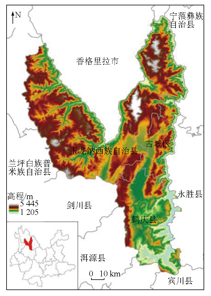
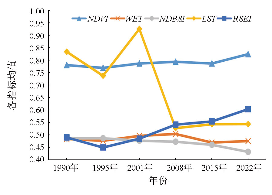
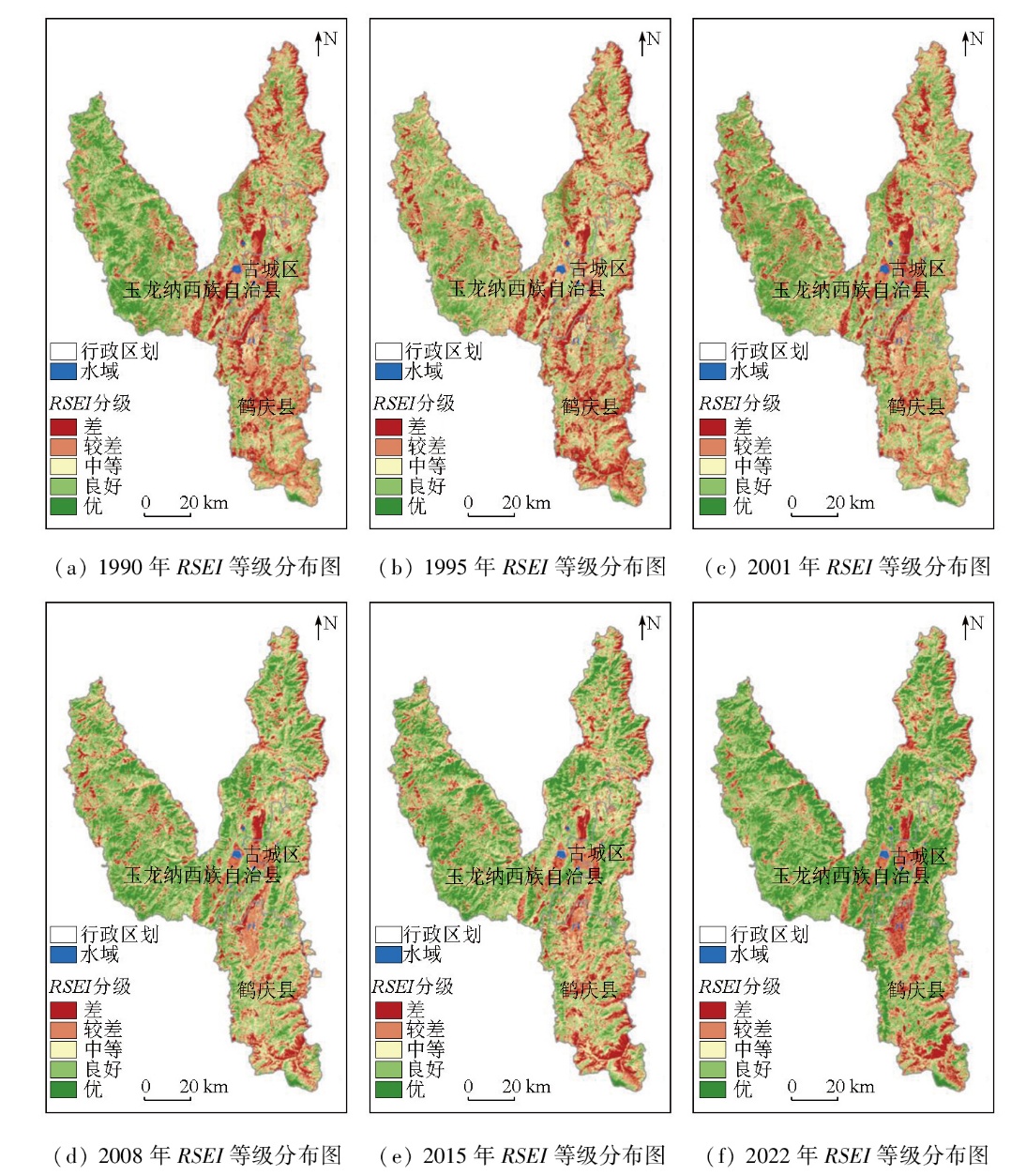
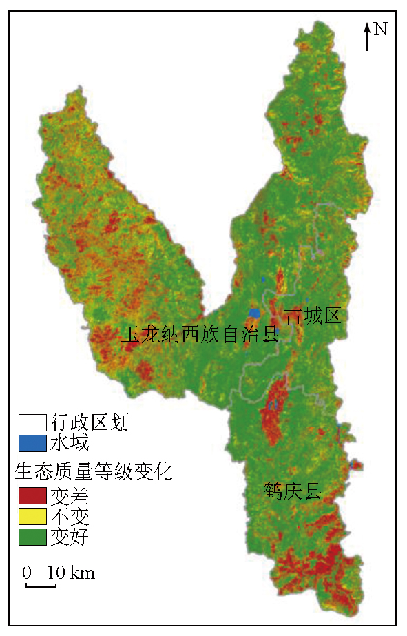
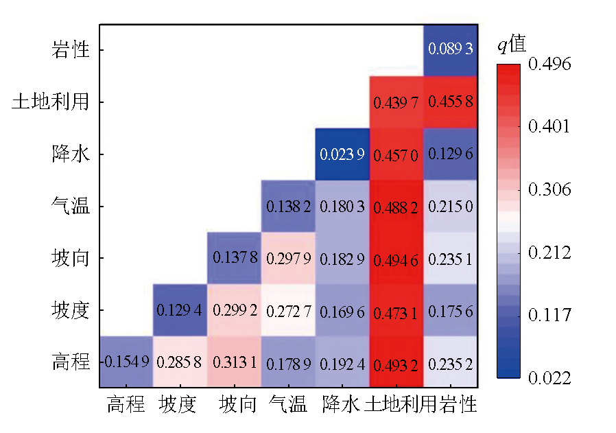
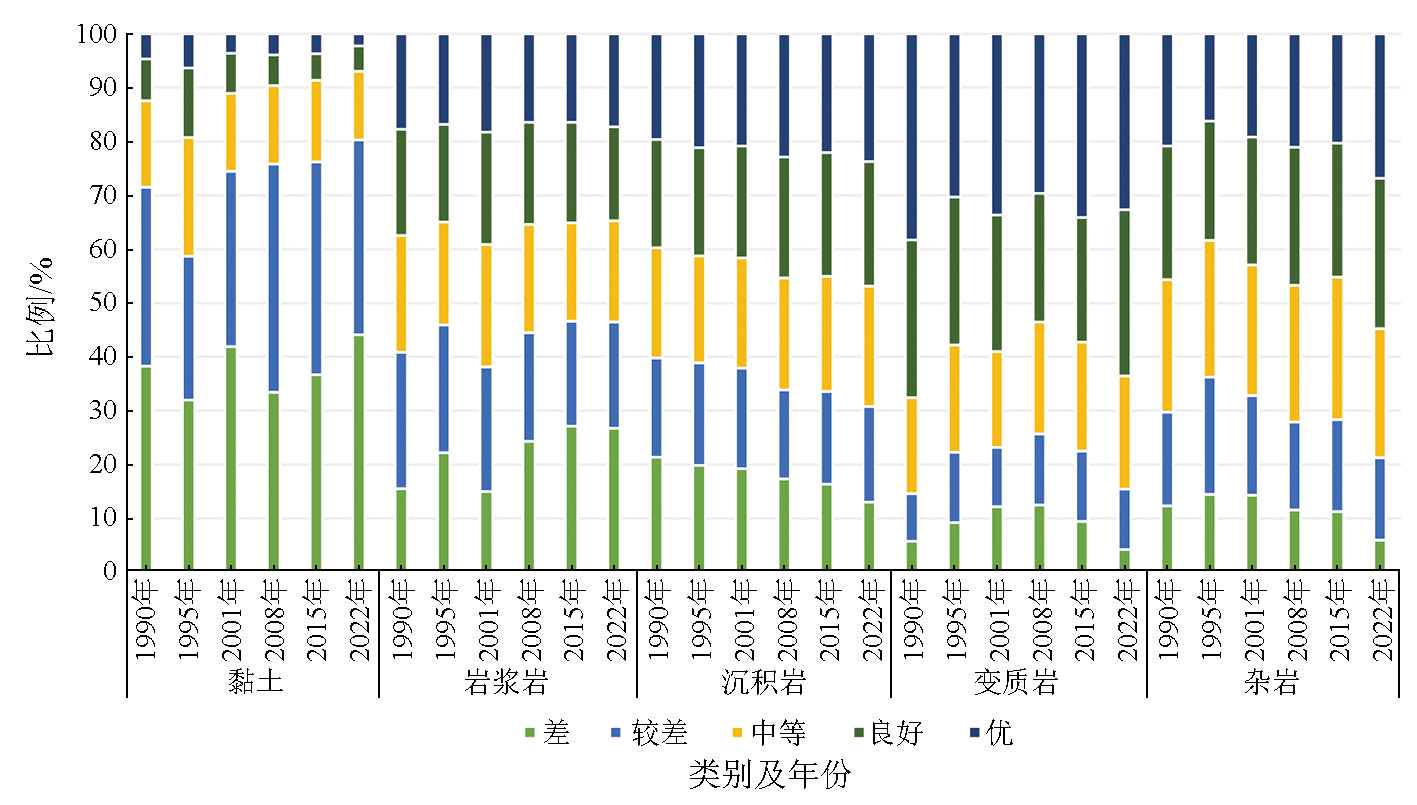
The alpine gorges in northwest Yunnan,important ecological reserves in China,are facing increasingly prominent environmental problems due to accelerated urbanization. Insights into the spatiotemporal changes in eco-environmental quality are of great significance for eco-environmental protection and construction in the alpine gorges of Northwest Yunnan. This study selected Landsat TM/OLI remote sensing images from 1990,1995,2001,2008,2015,and 2022 as the data source to extract four ecological indices:normalized difference vegetation Index (NDVI),wetness (WET),normalized difference bare soil index (NDBSI),and land surface temperature (LST). Consequently,a remote sensing ecological index (RSEI) was constructed to assess and monitor the eco-environmental quality of the alpine gorges in northwest Yunnan from 1990 to 2022. The results indicate that from 1990 to 2022,the average RSEI in the study area showed a trend of an initial decline followed by an increase. Specifically,the RSEI reached its lowest value of 0.450 in 1995 and then increased continuously from 0.450 in 1995 to 0.604 in 2022. Over this period,the proportion of areas with excellent and good eco-environmental quality increased by 22.03%,while those classified as poor and very poor eco-environmental quality decreased by 14.49%. These variations were predominantly composed of improvements,covering 62.42% of the study area. Spatially,areas with very poor quality were primarily concentrated in agricultural areas,urban construction land,along the Jinsha River,low-altitude areas with sparse vegetation,and the slopes of landform intermontane basins (Bazi) in Heqing County. In contrast,areas with excellent quality were mainly distributed in high-altitude mountainous regions characterized by lush vegetation and minimal human disturbance. Moreover,the land use type was identified as the main driving factor influencing the eco-environmental quality in the study area. The strongest interaction was observed between elevation (X1) and land use (X6),exerting the greatest impacts on eco-environmental quality in the study area. Besides,areas with clay soils were dominated by poor and very poor quality. The magmatic rock areas displayed a clear trend of ecological deterioration,while the sedimentary rock area presented significant improvements. Conversely,the metamorphic and complex rock areas maintained relative stability.
张萍, 庞咏, 陈庆松, 杨坤, 邹祖建, 侯云花, 王彩琼, 冯思齐. 基于RSEI模型的滇西北高山峡谷区生态环境质量动态监测及驱动因子分析[J]. 自然资源遥感, 2025, 37(5): 243-253.
ZHANG Ping, PANG Yong, CHEN Qingsong, YANG Kun, ZOU Zujian, HOU Yunhua, WANG Caiqiong, FENG Siqi. Dynamic monitoring and driving factor analysis for eco-environmental quality in alpine gorges of northwest Yunnan based on a remote sensing ecological index model. Remote Sensing for Natural Resources, 2025, 37(5): 243-253.
Xu Y, Zhou H R. Preliminary discussion on the research progress of ecological environment quality assessment in China[J]. Arid Land Geography, 2003, 26(2):166-172.
Tian J L. A review of research on regional ecological environment quality assessment[J]. Environmental Protection and Circular Economy, 2013, 33 (11):63-66.
[3]
Geng J W, Yu K Y, Xie Z, et al. Analysis of spatio-temporal variation and drivers of ecological quality in Fuzhou based on RSEI[J]. Remote Sensing, 2022, 14(19):4900.
Pan M H, Yuan Y N, Wang Y L, et al. Research on the changes in ecological environment quality of Qishan National Forest Park in Fuzhou based on RSEI[J]. Journal of Shandong Agricultural University(Natural Science Edition), 2020, 51 (1):57-63.
Fan Y H, Liu Y, Heng W J, et al. Analysis of the impact of coal mining on the ecological environment in Shendong mining area from 1990 to 2022 based on remote sensing ecological index[J]. Journal of Green Mine, 2024, 2 (1):41-53.
[6]
Jing Y, Zhang F, He Y, et al. Assessment of spatial and temporal variation of ecological environment quality in Ebinur Lake Wetland National Nature Reserve,Xinjiang,China[J]. Ecological Indicators, 2020, 110:105874.
Yang Z K, Tian J, Li W Y, et al. The spatiotemporal pattern and evolution trend of ecological environment quality in the Yellow River basin[J]. Acta Ecologica Sinica, 2021, 41 (19):7627-7636.
Li Y X, Li S H, Peng S Y. The spatiotemporal evolution of NDVI in the nine major plateau lake basins in Yunnan Province and its res-ponse to climate[J]. Research of Soil and Water Conservation, 2020, 27 (4):192-200.
Wen X D, Luo Z H, Fu L G. The impact of climate and land use change on the spatiotemporal changes of enhanced vegetation index in the Guangdong Hong Kong Macao Greater Bay Area[J]. Ecological Science, 2023, 42 (6):222-232.
Wu M F, Lin J. Research on surface temperature and heat island effect in the main urban area of Hangzhou City based on landsat images[J]. Science Technology and Engineering, 2022, 22 (24):10812-10817.
Xu S Z, Chen B, Zhou Y Y, et al. Research on remote sensing monitoring of spatiotemporal changes in vegetation coverage in mining areas:A case study of Dabaoshan mining area in Guangdong Province[J]. Journal of Anhui Agricultural Sciences, 2023, 51 (5):46-50.
Cheng L L, Wang Z W, Tian S F, et al. Ecological environment quality evaluation of Mentougou District,Beijing based on improved remote sensing ecological index[J]. Chinese Journal of Ecology, 2021, 40 (4):1177-1185.
[14]
Liu Q, Yu F H, Mu X M. Evaluation of the ecological environment quality of the Kuye River source basin using the remote sensing eco-logical index[J]. International Journal of Environmental Research and Public Health, 2022, 19(19):12500.
[15]
Baig M H A, Zhang L F, Shuai T, et al. Derivation of atasselled cap transformation based on Landsat-8 satellite reflectance[J]. Remote Sensing Letters, 2014, 5(5):423-431.
[16]
Crist E P. A TM tasseled cap equivalent transformationfor reflectance factor data[J]. Remote Sensing of Environment, 1985, 17(3):301-306.
Lin X, Ji J W, Sha J M. Research on remote sensing monitoring of environmental changes in Datian County over the past 22 years[J]. Journal of Fujian Normal University(Natural Science Edition), 2018, 34 (5):24-31.
Xu H Q. Remote sensing assessment of ecological changes in soil erosion areas[J]. Transactions of the Chinese Society of Agricultural Engineering, 2013, 29 (7):91-97,294.
[19]
Janet N. Remote sensing of urban heat island by day and night[J]. Photogrammetric Engineering and Remote Sensing, 2005, 71(5):613-621.
[20]
Chander G, Markham B L, Helder D L. Summary of current radiometric calibration coefficients for Landsat MSS,TM,ETM+,and EO-1 ALI sensors[J]. Remote Sensing of Environment, 2009, 113(5):893-903.
[21]
Yu X, Guo X, Wu Z. Land surface temperature retrieval from Landsat 8 TIRS-comparison between radiative transfer equation-based method,split window algorithm and single channel method[J]. Remote Sensing, 2014, 6(10):9829-9852.
[22]
Sobrino J A, Jimenez-munoz J C, Paolini L. Land surface retrieval from Landsat TM5[J]. Remote Sensing of Environment, 2004, 90(4):434-440.
Ministry of Environmental Protection of the People’s Republic of China. Technical specification for ecological environment assessment:HJ 192—2015[S]. Beijing: China Environmental Science Press, 2015.
 2025, Vol. 37
  ), 庞咏1(