Remote sensing-based assessment of ecological quality in open-pit coal mining areas based on the pressure-state-response and time series prediction models
LIU Jinyu1(), HU Jinshan1(), KANG Jianrong1, ZHU Yihu2, WANG Shengli2
1. School of Geography, Geomatics and Planning, Jiangsu Normal University, Xuzhou 221116, China 2. Jiangsu Geologic Surveying and Mapping Institute, Nanjing 211102, China
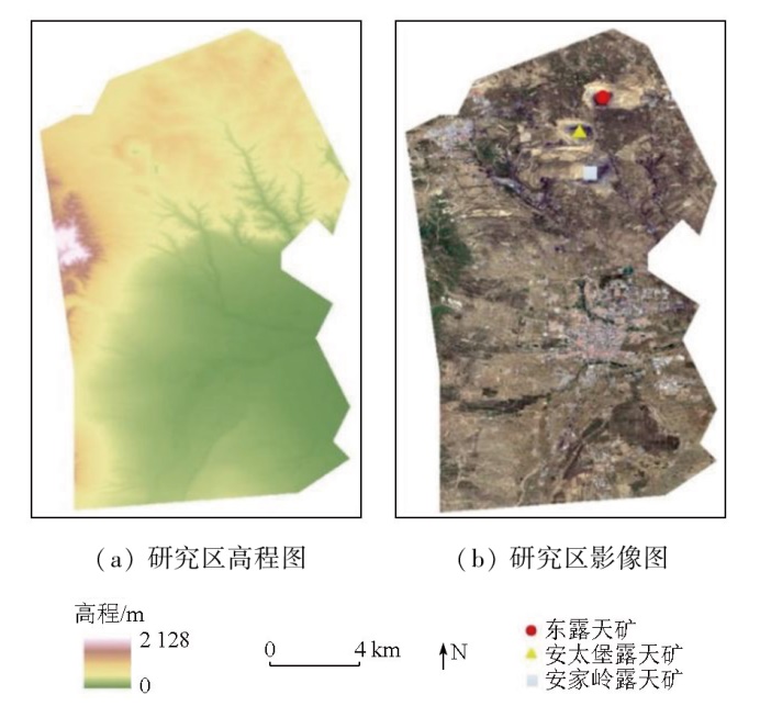
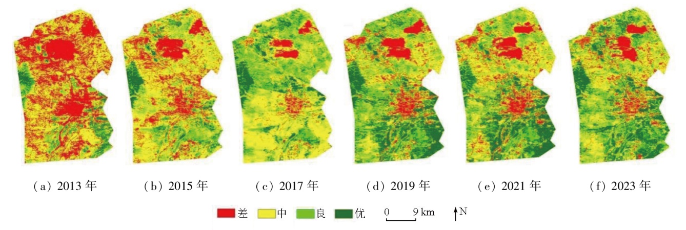
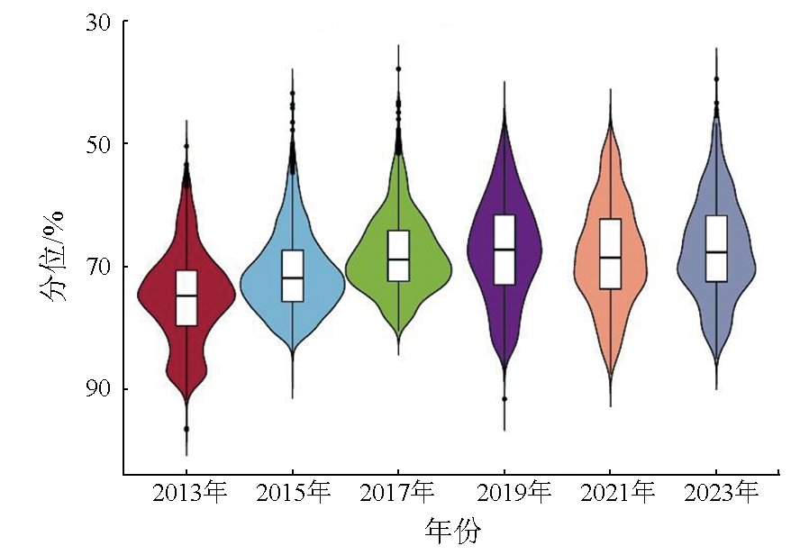
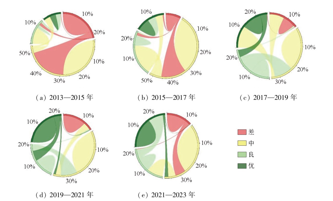
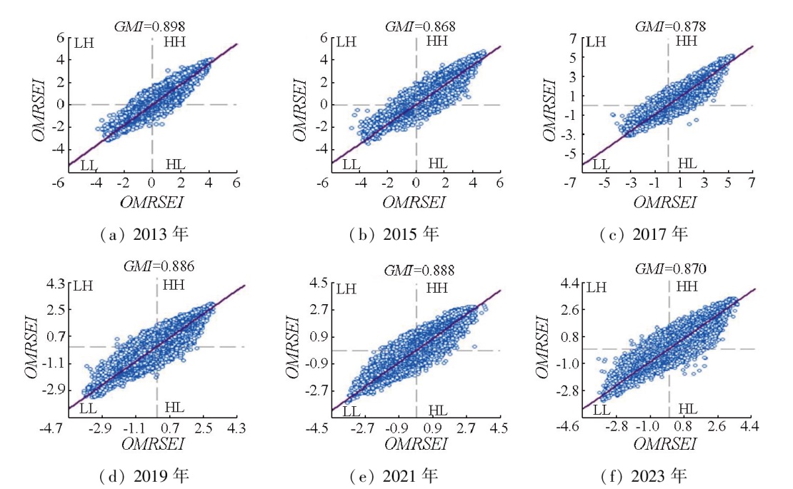
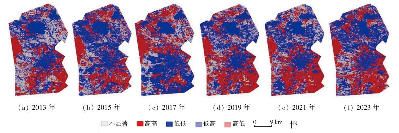
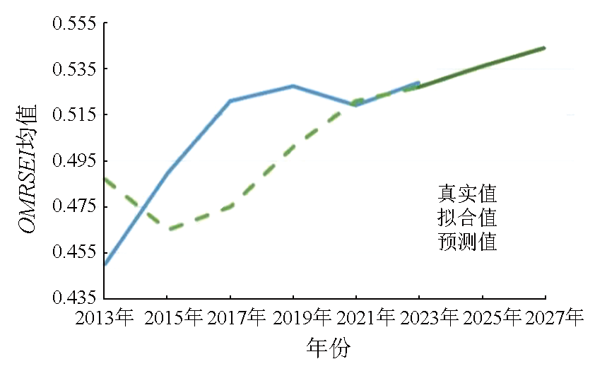
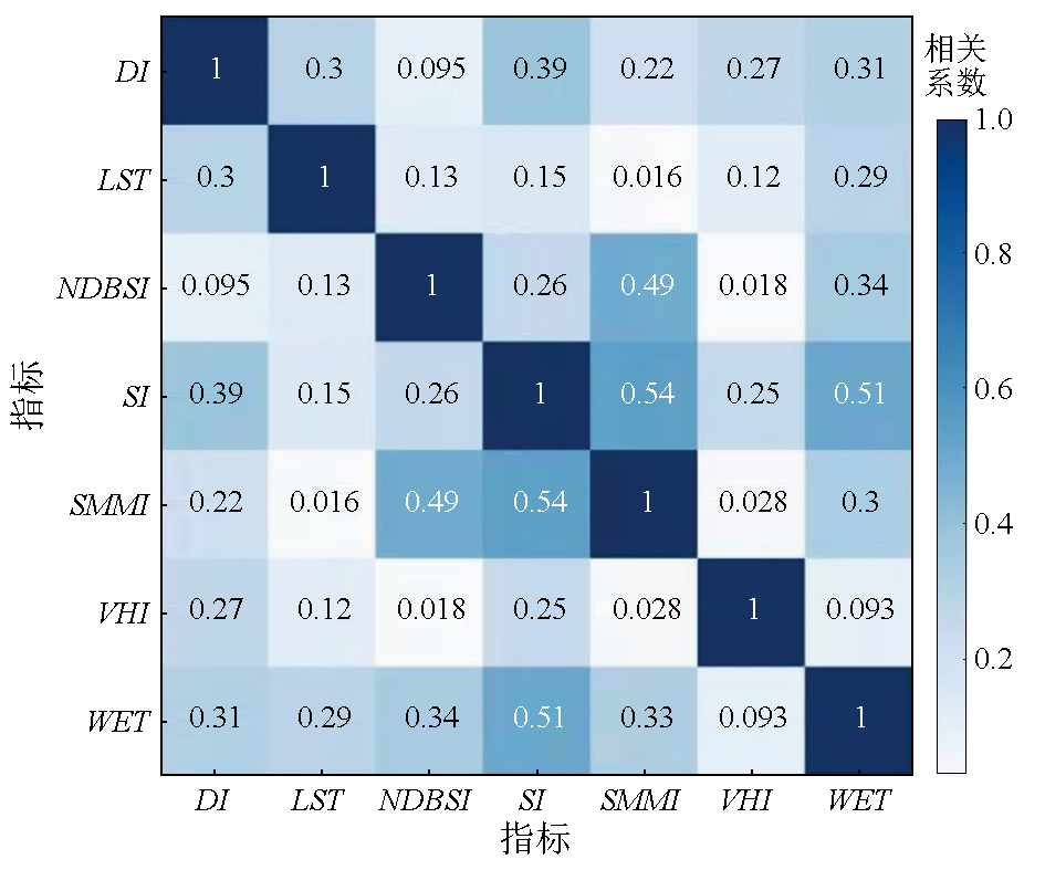
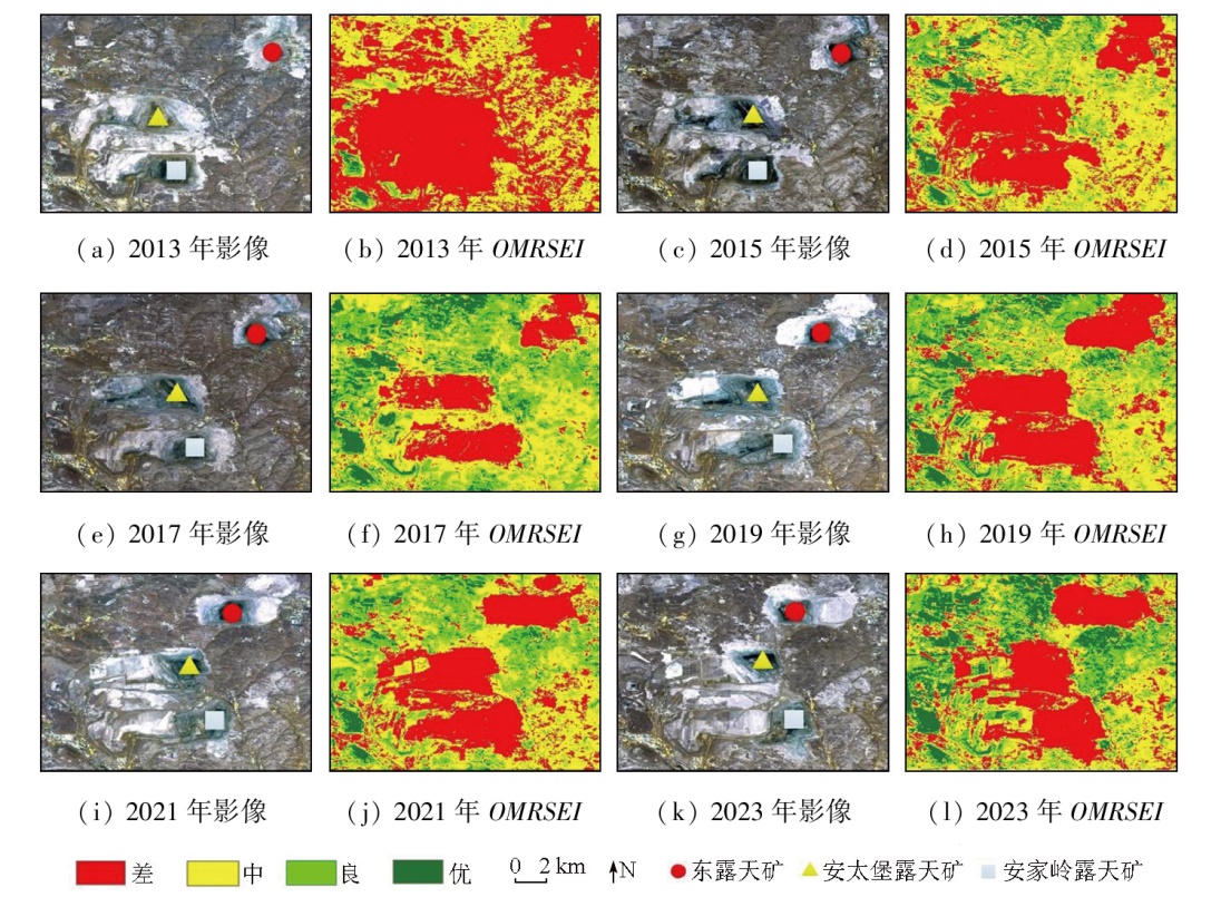
To quantify the mining disturbance of open-pit coal mines to surrounding ecosystems, this study investigated the Pingshuo mining area in Shanxi Province. Based on the pressure-state-response (PSR) model, seven types of assessment indicators were selected to construct the remote sensing ecological index of open-pit coal mining area (OMRSEI) through combination weighting. The validity of the OMRSEI was verified through correlation and comparative analyses. Moreover, the trend of ecological evolution in the study area for the next two years was predicted using the exponential smoothing method. The results indicate that the OMRSEI exhibited significant spatial correlation and validity, establishing it as an effective remote sensing indicator for ecological assessment in open-pit coal mining areas. The study area manifested an overall enhanced ecological quality from 2013 to 2023. Specifically, the Antaibao and Anjialing open-pit coal mines witnessed continuously improved ecological quality due to the progressive restoration of waste dumps. In contrast, the Dong open-pit coal mine displayed an ecological quality trend characterized by a first decline and then recovery. The average OMRSEI of the study area is predicted to continuously rise from 2025 to 2027, indicating sustained enhancement in ecological quality.
刘晋宇, 胡晋山, 康建荣, 朱益虎, 王胜利. 基于PSR和时序预测模型的露天煤矿区生态环境质量遥感评价[J]. 自然资源遥感, 2025, 37(6): 182-190.
LIU Jinyu, HU Jinshan, KANG Jianrong, ZHU Yihu, WANG Shengli. Remote sensing-based assessment of ecological quality in open-pit coal mining areas based on the pressure-state-response and time series prediction models. Remote Sensing for Natural Resources, 2025, 37(6): 182-190.
Xu D L, Li X F, Chen J, et al. Research progress of soil and vegetation restoration technology in open-pit coal mine:A review[J]. Agriculture, 2023, 13(2):226.
doi: 10.3390/agriculture13020226
Li S Z, Li X L, Yin D W. Several basic issues of ecological restoration of coal mines under background of carbon neutrality[J]. Coal Science and Technology, 2022, 50(1):286-292.
Zhang C Y, Li J, Lei S G, et al. Progress and prospect of the quantitative remote sensing for monitoring the eco-environment in mi-ning area[J]. Metal Mine, 2022(3):1-27.
Yu Y, Chen B Q, Hua F F, et al. Research status and prospect of mining-induced geo-environmental hazards and geological environment protection[J]. Metal Mine, 2024(3):1-18.
[5]
Zhang Z, Li G Q, Su X B, et al. Geochemical controls on the enrichment of fluoride in the mine water of the Shendong mining area,China[J]. Chemosphere, 2021,284:131388.
[6]
Lian M, Shang L H, Duan Z, et al. LiDAR mapping of atmospheric atomic mercury in the Wanshan area,China[J]. Environmental Pollution, 2018,240:353-358.
[7]
Han X Y, Cao T Y, Yan X L. Comprehensive evaluation of ecological environment quality of mining area based on sustainable deve-lopment indicators:A case study of Yanzhou Mining in China[J]. Environment,Development and Sustainability, 2021, 23(5):7581-7605.
doi: 10.1007/s10668-020-00935-3
Sun H F, Li Y H, Ji Y F, et al. Spatial distribution and ecological significance of heavy metals in soils from Chatian mercury mining deposit,western Hunan Province[J]. Environmental Science, 2009, 30(4):1159-1165.
[9]
Tian W X, Li Z Y, Liu W, et al. Grey clustering evaluation on regional eco-environmental quality based on normalized index value[J]. Meteorological and Environmental Research, 2011, 2(4):65-71.
[10]
Zhuang Q W, Wu S X, Yan Y Y, et al. Monitoring land surface thermal environments under the background of landscape patterns in arid regions:A case study in Aksu River basin[J]. Science of The Total Environment, 2020,710:136336.
Xu Z J, Hou H P, Zhang S L, et al. Effects of mining activity and climatic change on ecological losses in coal mining areas[J]. Transactions of the Chinese Society of Agricultural Engineering, 2012, 28(5):232-240.
Qin L, Chen B Q, Yu Y, et al. Study on the spatio-temporal variation regularity of ecological environment before and after mine closure based on remote sensing ecological index[J]. Metal Mine, 2023(3):242-249.
Chen X S, Chen Y, Lu H, et al. Temporal and spatial dynamic monitoring of landscape pattern and ecological environment in Yineng mining area[J]. Remote Sensing Technology and Application, 2024, 39(2):426-434.
Liu Y, Hu X, Yue H, et al. Ecological environmental assessment of Gobi desert open-pit mine based on time series model[J]. Coal Science and Technology, 2023, 51(12):125-139.
Zhong A Y, Sun J, Hu C M, et al. Evaluation and prediction of ecological environment restoration effect of Beijing Wangping Coal Mine based on RSEI[J]. Mining Safety and Environmental Protection, 2023, 50(4):89-96.
Wang J Y, Lu C W, Li F B, et al. Research on ecological security evaluation of open-pit mine area based on PSR and GA-Elman model[J]. China Mining Magazine, 2020, 29(2):65-71.
[19]
Nie X R, Hu Z Q, Ruan M Y, et al. Remote-sensing evaluation and temporal and spatial change detection of ecological environment quality in coal-mining areas[J]. Remote Sensing, 2022, 14(2):345.
doi: 10.3390/rs14020345
Wu S Y, Zhu Q L, Wu W. An evaluation research on ecological security evaluation of Dalian Bay coastal zone based on the Pressure-State-Response model[J/OL]. Transactions of Oceanology and Limnology, 2024:1-10.(2024-04-01).https://kns.cnki.net/kcms/detail/37.1141.P.20240401.1502.002.html.
Feng H Y, Feng Z K, Feng H X. One new method of PM2.5 concentration inversion based on difference index[J]. Spectroscopy and Spectral Analysis, 2018, 38(10):3012.
[22]
Yi Z Y, Liu M L, Liu X N, et al. Long-term Landsat monitoring of mining subsidence based on spatiotemporal variations in soil moisture:A case study of Shanxi Province,China[J]. International Journal of Applied Earth Observation and Geoinformation, 2021,102:102447.
[23]
Alexander C. Normalised difference spectral indices and urban land cover as indicators of land surface temperature (LST)[J]. International Journal of Applied Earth Observation and Geoinformation, 2020,86:102013.
[24]
Gorji T, Sertel E, Tanik A. Monitoring soil salinity via remote sen-sing technology under data scarce conditions:A case study from Turkey[J]. Ecological Indicators, 2017,74:384-391.
[25]
Wu R M X, Zhang Z W, Yan W J, et al. A comparative analysis of the principal component analysis and entropy weight methods to establish the indexing measurement[J]. PLoS One, 2022, 17(1):e0262261.
Fang S J, Xiao Q. Research on regional ecological well-being performance and spatial effect in China[J]. China Population,Resources and Environment, 2019, 29(3):1-10.
[27]
Billah B, King M L, Snyder R D, et al. Exponential smoothing model selection for forecasting[J]. International Journal of Forecasting, 2006, 22(2):239-247.
doi: 10.1016/j.ijforecast.2005.08.002
Shuozhou Municipal People’s Government. Notice on the issuance of the “14th Five-Year Plan” ecological and environmental protection plan of Shuozhou City:Shuo Zheng Fa [2022]No.36[A/OL].(2022-8-26)[2024-6-12].http://szxxgk.shuozhou.gov.cn/zfwj_1/202212/t20221216_420310.shtml.
Zhang J, Yang L P, Gong E J, et al. Dynamic monitoring of eco-environmental quality in Xi’an based on GEE and adjusted RSEI[J]. Acta Ecologica Sinica, 2023, 43(5):2114-2127.
 2025, Vol. 37
  ), 胡晋山1(