Please wait a minute...
 
国土资源遥感  2018, Vol. 30 Issue (1): 217-223    DOI: 10.6046/gtzyyg.2018.01.30
  本期目录 | 过刊浏览 | 高级检索 |
新疆玛纳斯湖近40年间时空变化图谱及其驱动机制
胡尔西别克·孜依纳力1(), 毋兆鹏1,2(), 哈孜亚·包浪提将1
1.新疆师范大学地理科学与旅游学院,乌鲁木齐 830054
2.新疆维吾尔自治区干旱区湖泊环境与资源重点实验室,乌鲁木齐 830054
Lake changes in spatial evolution and driving force for the water area change of the Manas Lake in Xinjiang in the past forty years
Hurixbek·Ziyinali1(), Zhaopeng WU1,2(), Kazya·Baolangtijiang1
1. College of Geography and Tourism Science, Xinjiang Normal University, Urumqi 830054, China
2. Key Laboratory of Arid Land Lake Environment and Resource Xinjiang Uyghur Autonomous Region, Urumqi 830054, China
全文: PDF(987 KB)   HTML  
输出: BibTeX | EndNote (RIS)      
摘要 

以新疆玛纳斯湖为研究区,利用1972—2014年间8期遥感影像数据,在提取了湖泊水域信息的基础上对近40 a间玛纳斯湖水域演化进行了研究。结果表明,1972—2014年间玛纳斯湖呈现明显“增加—减小—增加—减小”变化态势,水域重心不断往西南方向偏移。1972—1999年间玛纳斯湖长期处于干涸状态,2000年恢复至研究期间最大水域面积(248.69 km2),之后经历了2000—2008年和2011—2014年2次萎缩周期,面积变化幅度和动态度的计算结果显示,水域面积的退缩周期在缩短,退缩速度在加快。玛纳斯湖水域面积变化整体受气候变化的影响不大,但与极端高温和降水天气引起的超标准洪水关系密切,流域内人类活动是玛纳斯湖演化的主要原因。

服务
把本文推荐给朋友
加入引用管理器
E-mail Alert
RSS
作者相关文章
胡尔西别克·孜依纳力
毋兆鹏
哈孜亚·包浪提将
关键词 玛纳斯湖时空变化图谱驱动机制遥感    
Abstract

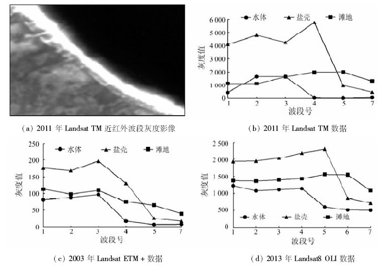
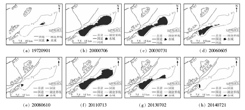
With the Manas Lake in Xinjiang as the study area,by using eight remote sensing images from 1972 to 2014, and on the basis of extracting the information of lake water, the authors analyzed the evolution of the Manas Lake area in the past forty years. The results are as follows: The Manas Lake showed a significant “increase-decrease-increase-decrease” trend of change from 1972 to 2014, and the barycenter of water area was migrating in southwest direction. Lake had dried up from 1972 to 1999, then it restored the largest water area (248.69 km2) in 2000,and after that it experienced two shrinking periods that happened in 2000—2008 and 2011—2014 respectively. Calculation result of area variation amplitude and dynamic degree shows that the shrinking period of the water area was shortened and the shrinking speed increased. In the past forty years or so, the change trend of lake water area was not consistent with the change trend of the Manas River. The authors point out that climate change has little effect on the change of the water area of the Manas Lake, but has an intimate relationship with extraordinary flood caused by extremely high temperature and extreme precipitation, and that human activities in the basin constitute the main reason for the evolution of the Manas Lake, which causes the declining of the function of supplying water resources to the lower reaches.

Key wordsManas Lake    spatial evolution    driving forces    remote sensing
收稿日期: 2016-09-09      出版日期: 2018-02-08
:  X144  
基金资助:新疆维吾尔自治区科技支撑项目“玛纳斯湖退化湿地生态恢复研究”(编号: 201533109)、国家自然科学基金项目“新疆艾比湖流域潜在土地利用冲突动态演变及建模研究”(编号: 41761113)、新疆师范大学地理学博士点开放课题“玛纳斯湖退化湿地景观格局变化研究”(编号: XJNU-DL-201604)和新疆师范大学“十三五”校级重点学科地理学项目共同资助
作者简介:

第一作者: 胡尔西别克·孜依纳力(1992-),男,硕士研究生,主要从事3S技术与绿洲资源开发研究。Email:614034202@qq.com

引用本文:   
胡尔西别克·孜依纳力, 毋兆鹏, 哈孜亚·包浪提将. 新疆玛纳斯湖近40年间时空变化图谱及其驱动机制[J]. 国土资源遥感, 2018, 30(1): 217-223.
Hurixbek·Ziyinali, Zhaopeng WU, Kazya·Baolangtijiang. Lake changes in spatial evolution and driving force for the water area change of the Manas Lake in Xinjiang in the past forty years. Remote Sensing for Land & Resources, 2018, 30(1): 217-223.
链接本文:  
https://www.gtzyyg.com/CN/10.6046/gtzyyg.2018.01.30      或      https://www.gtzyyg.com/CN/Y2018/V30/I1/217
Fig.1  研究区位置示意图
序号 数据类型 行列号 获取时间 空间分辨率/m
1 MSS 144/28 19720901 60
2 ETM+ 144/28 20000706 30
3 ETM+ 144/28 20030731 30
4 ETM+ 144/28 20060605 30
5 ETM+ 144/28 20080610 30
6 TM 144/28 20110713 30
7 OLI 144/28 20130702 30
8 OLI 144/28 20140721 30
Tab.1  遥感影像数据源
Fig.2  遥感数据的波段突变曲线
获取时间 数据类型 波段类型 阈值范围
19720901 MSS NDVI [-0.36,-0.10]
20000706 ETM+ NDVI [-1.14 ,-0.11]
20030731 ETM+ NDVI [-0.79,-0.43]
20060605 ETM+ NDVI [-0.66,-0.29]
20080610 ETM+ NDVI [-0.58,-0.31]
20110713 TM NDVI [-1.56,-0.27]
20130702 OLI B5 [574 ,1 335]
20140721 OLI B5 [582 ,1 391]
Tab.2  遥感影像波段阈值范围
Fig.3  玛纳斯湖水域面积时空变化
Fig.4  玛纳斯湖水域面积统计
Fig.5  玛纳斯湖重心位移
年份 变化面积/km2 变化幅度
(R)/%
动态度
(Rs)/%
1972—2000年 239.28 2 542.83 90.82
2000—2003年 -48.78 -19.61 -6.54
2003—2006年 -126.40 -63.23 -21.07
2006—2008年 -68.36 -92.99 -46.49
2008—2011年 238.33 4 627.77 1 542.59
2011—2013年 -135.36 -55.59 -27.79
2013—2014年 -102.64 -94.93 -94.93
1972—2014年 -3.93 -41.76 -99.44
Tab.3  玛纳斯湖水域面积变化、变化幅度和动态度
Fig.6  玛纳斯河肯斯瓦特水文站年径流量
Fig.7  玛纳斯河极值洪峰流量
Fig.8  玛纳斯河流域1970—2014年间人口数量和GDP变化
[1] 柯长青. 湖泊遥感研究进展[J]. 海洋湖沼通报, 2004(4):81-86.
Ke C Q.A review of monitoring lake environment change by means of remote sensing[J]. Transactions of Oceanology and Limnology, 2004(4):81-86.
[2] 阿布都米吉提·阿布力克木,阿里木江·卡斯木,艾里西尔·库尔班,等.近40年台特玛—康拉克湖泊群水域变化遥感监测[J].湖泊科学,2014,26(1):46-54.
Ablekim A,Kasimu A,Kurban A,et al.Monitoring the water area changes in Tetima—Kanglayka Lakes region over the past four decades by remotely sensed data[J].Journal of Lake Sciences,2014,26(1):46-54.
[3] 成晨,傅文学,胡召玲,等.基于遥感技术的近30年中亚地区主要湖泊变化[J].国土资源遥感,2015,27(1):146-152.doi:10.6046/gtzyyg.2015.01.23.
Cheng C,Fu W X,Hu Z L,et al.Changes of major lakes in Central Asia over the past 30 years revealed by remote sensing technology[J].Remote Sensing for Land and Resources,2015,27(1):146-152.10.6046/gtzyyg.2015.01.23.
[4] 张振瑜,王乃昂,吴月,等.1973—2010年巴丹吉林沙漠腹地湖泊面积空间变化的遥感分析[J].湖泊科学,2013,25(4):514-520.
Zhang Z Y,Wang N A,Wu Y,et al.Remote sensing on spatial changes of lake area in Badain Jaran Desert hinterland during 1973—2010[J].Journal of Lake Sciences,2013,25(4):514-520.
[5] 张飞,王娟,塔西甫拉提·特依拜,等.1998—2013年新疆艾比湖湖面时空动态变化及其驱动机制[J].生态学报,2015,35(9):2848-2859.
Zhang F,Wang J,Tashpolat T,et al.The spatial and temporal dynamic changes and driving forces in the surface area of Ebinur Lake from 1998—2013[J].Acta Ecologica Sinica,2015,35(9):2848-2859.
[6] 封玲,田晓明.玛纳斯河流域农业开发与水资源分配格局的改变及其生态效应[J].中国农史,2006,25(1):119-126,133.
Feng L,Tian X M.The change of water resource distribution and its ecological effects caused by the agriculture development in Manasi River Valley in modern time[J].Agricultural History of China,2006,25(1):119-126,133.
[7] 郭敬辉,汤奇成,郭知教,等.新疆水文地理[M].北京:科学出版社,1966:36-41.
Guo J H,Tang Q C,Guo Z J,et al.Hydrological Geography in Xinjiang[M].Beijing:Science Press,1966:36-41.
[8] 李晖,肖鹏峰,冯学智,等.近30年三江源地区湖泊变化图谱与面积变化[J].湖泊科学,2010,22(6):862-873.
Li H,Xiao P F,Feng X Z,et al.Lake changes in spatial evolution and area in source region of Three Rivers in recent 30 years[J].Journal of Lake Sciences,2010,22(6):862-873.
[9] 李磊,李艳红,陈成贺日,等.1972—2011年期间艾比湖面积变化研究[J].湿地科学,2014,12(2):263-267.
Li L,Li Y H,Chen C H R,et al.Change of Ebinur Lake area during 1972—2011[J].Wetland Science,2014,12(2):263-267.
[10] 许诗,刘志明,王宗明,等.1986—2008年吉林省湖泊变化及驱动力分析[J].湖泊科学,2010,22(6):901-909.
Xu S,Liu Z M,Wang Z M,et al.Dynamics of lake area changes and its driving force analysis in Jilin Province from 1986 to 2008[J].Journal of Lake Sciences,2010,22(6):901-909.
[11] 姚永慧,汪小钦,周成虎,等.新疆玛纳斯湖近50年来的变迁[J].水科学进展,2007,18(1):17-23.
Yao Y H,Wang X Q,Zhou C H,et al.Changes of Manas Lake in the past 50 years in Xinjiang Province[J].Advances in Water Science,2007,18(1):17-23.
[12] Estrella N,Menzel A.Recent and future climate extremes arising from changes to the bivariate distribution of temperature and precipitation in Bavaria,Germany[J].International Journal of Climatology,2013,33(7):1687-1695.
[13] 赵勇,黄丹青,朱坚,等.北疆极端降水事件的区域性和持续性特征分析[J].冰川冻土,2011,33(3):524-531.
Zhao Y,Huang D Q,Zhu J,et al.The feature analysis of regional and persistent extreme precipitation events in Northern Xinjiang Region[J].Journal of Glaciology and Geocryology,2011,33(3):524-531.
[14] 邹全,王国亚,贺斌,等.1957—2010年天山玛纳斯河流域夏季径流及洪水过程对极端气候事件的响应[J].冰川冻土,2013,35(3):733-740.
Zou Q,Wang G Y,He B,et al.Responding of summer runoff and flood processes to extreme climate events in Manas River basin,Tianshan Mountains during 1957—2010[J].Journal of Glaciology and Geocryology,2013,35(3):733-740.
[1] 刘文, 王猛, 宋班, 余天彬, 黄细超, 江煜, 孙渝江. 基于光学遥感技术的冰崩隐患遥感调查及链式结构研究——以西藏自治区藏东南地区为例[J]. 自然资源遥感, 2022, 34(1): 265-276.
[2] 王茜, 任广利. 高光谱遥感异常信息在阿尔金索拉克地区铜金矿找矿工作中的应用[J]. 自然资源遥感, 2022, 34(1): 277-285.
[3] 吕品, 熊丽媛, 徐争强, 周学铖. 基于FME的矿山遥感监测矢量数据图属一致性检查方法[J]. 自然资源遥感, 2022, 34(1): 293-298.
[4] 张大明, 张学勇, 李璐, 刘华勇. 一种超像素上Parzen窗密度估计的遥感图像分割方法[J]. 自然资源遥感, 2022, 34(1): 53-60.
[5] 薛白, 王懿哲, 刘书含, 岳明宇, 王艺颖, 赵世湖. 基于孪生注意力网络的高分辨率遥感影像变化检测[J]. 自然资源遥感, 2022, 34(1): 61-66.
[6] 宋仁波, 朱瑜馨, 郭仁杰, 赵鹏飞, 赵珂馨, 朱洁, 陈颖. 基于多源数据集成的城市建筑物三维建模方法[J]. 自然资源遥感, 2022, 34(1): 93-105.
[7] 李伟光, 侯美亭. 植被遥感时间序列数据重建方法简述及示例分析[J]. 自然资源遥感, 2022, 34(1): 1-9.
[8] 丁波, 李伟, 胡克. 基于同期光学与微波遥感的茅尾海及其入海口水体悬浮物反演[J]. 自然资源遥感, 2022, 34(1): 10-17.
[9] 高琪, 王玉珍, 冯春晖, 马自强, 柳维扬, 彭杰, 季彦桢. 基于改进型光谱指数的荒漠土壤水分遥感反演[J]. 自然资源遥感, 2022, 34(1): 142-150.
[10] 张秦瑞, 赵良军, 林国军, 万虹麟. 改进遥感生态指数的宜宾市三江汇合区生态环境评价[J]. 自然资源遥感, 2022, 34(1): 230-237.
[11] 贺鹏, 童立强, 郭兆成, 涂杰楠, 王根厚. 基于地形起伏度的冰湖溃决隐患研究——以希夏邦马峰东部为例[J]. 自然资源遥感, 2022, 34(1): 257-264.
[12] 艾璐, 孙淑怡, 李书光, 马红章. 光学与SAR遥感协同反演土壤水分研究进展[J]. 自然资源遥感, 2021, 33(4): 10-18.
[13] 李特雅, 宋妍, 于新莉, 周圆锈. 卫星热红外温度反演钢铁企业炼钢月产量估算模型[J]. 自然资源遥感, 2021, 33(4): 121-129.
[14] 刘白露, 管磊. 南海珊瑚礁白化遥感热应力检测改进方法研究[J]. 自然资源遥感, 2021, 33(4): 136-142.
[15] 吴芳, 金鼎坚, 张宗贵, 冀欣阳, 李天祺, 高宇. 基于CZMIL测深技术的海陆一体地形测量初探[J]. 自然资源遥感, 2021, 33(4): 173-180.
Viewed
Full text


Abstract

Cited

  Shared   
  Discussed   
京ICP备05055290号-2
版权所有 © 2015 《自然资源遥感》编辑部
地址:北京学院路31号中国国土资源航空物探遥感中心 邮编:100083
电话:010-62060291/62060292 E-mail:zrzyyg@163.com
本系统由北京玛格泰克科技发展有限公司设计开发