1.Tianjin Centre, China Geological Survey, Tianjin 300170, China 2.School of Environmental and Municipal Engineering, Tianjin Urban Construction College, Tianjin 300384, China
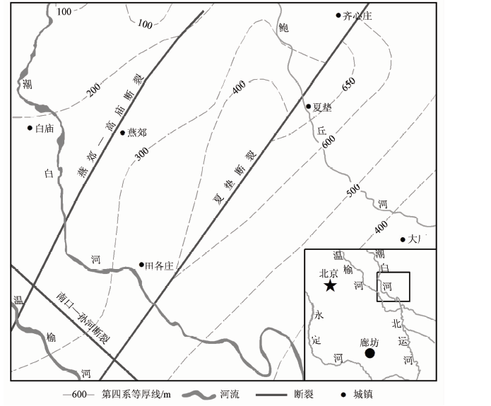
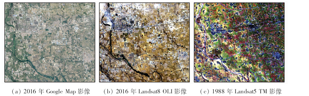
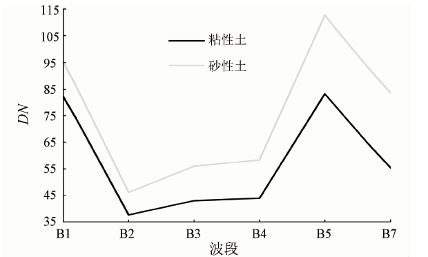
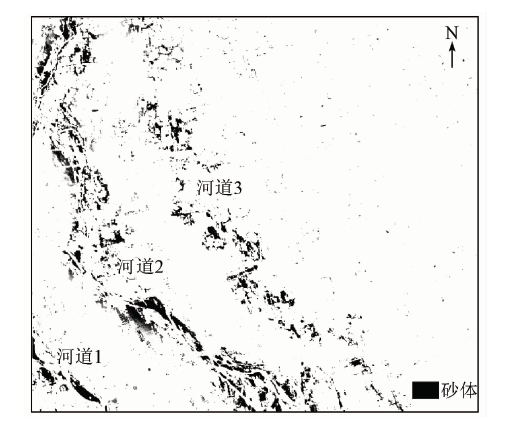
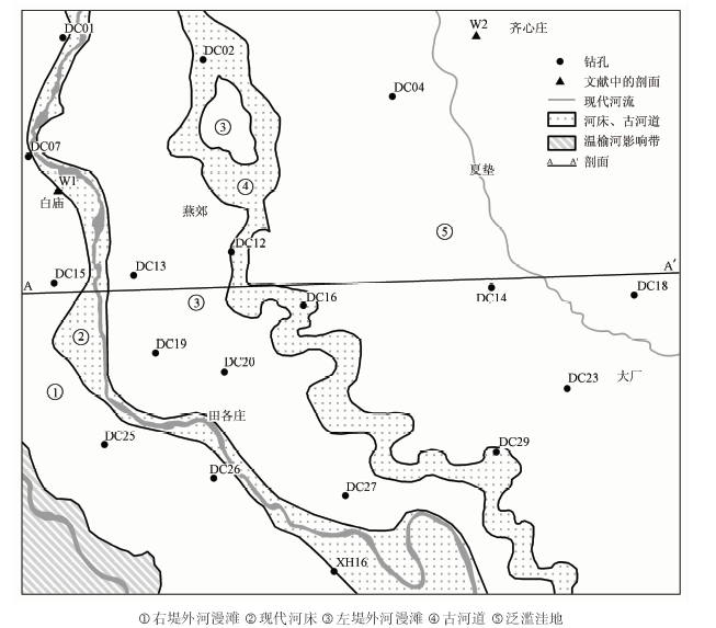
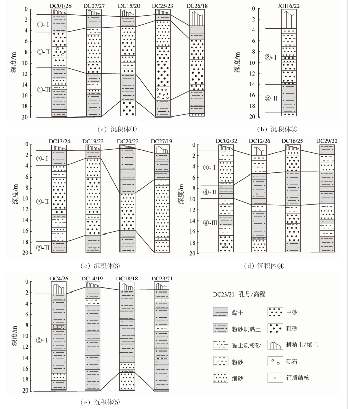
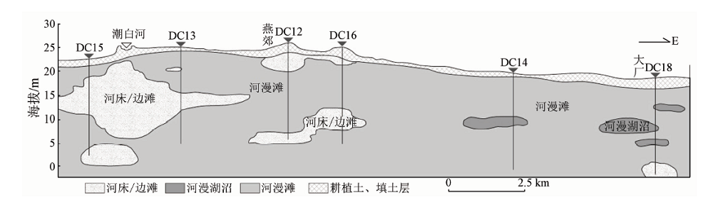
According to the reflectance spectroscopy of remote sensing (RS) data of field sandy soil and cohesive soil, the shallow sedimentary framework in the middle reach of Chaobai River (MRCR) was interpreted and proved by sediment cores. Considering regional and vertical variation, the authors investigated the macro-characteristics of the sedimentation in the MRCR. The results show that early mid-low spatial resolution Landsat TM data are effective in identifying sandy soil and cohesive soil, and the two kinds of soil have obviously different colors in B7(R), B4(G)and B1(B), and the change of grain size can be reflected by color saturation. The shallow sediment cores are in good agreement with RS interpretation. Finally, the shallow deposits can be divided into five parts: the left floodplain, the recent riverbed, the right floodplain, the paleo-river and the flood lowland. Among them, paleo-rivers are developed in shallow layer as lenses, while the other parts exhibit inherited development at the depth of 20 m and shift with the river swinging.
张竞, 纪冬丽, 白耀楠, 苗晋杰, 郭旭, 杜东, 裴艳东. 基于遥感的潮白河中游冲积平原宏观沉积特征[J]. 国土资源遥感, 2019, 31(1): 156-163.
Jing ZHANG, Dongli JI, Yaonan BAI, Jinjie MIAO, Xu GUO, Dong DU, Yandong PEI. Research on the macro-characteristics of the sedimentation in the middle reach of Chaobai River based on remote sensing. Remote Sensing for Land & Resources, 2019, 31(1): 156-163.
Liu J L, Pang Z H, Wang S F , et al. Impact of precipitation change and human activities on groundwater regime in the Chaobaihe alluvialand diluvial fan in Beijing in the last 30 years[J]. Quaternary Sciences, 2010,30(1):138-144.
Liu Z R, Shen J, Huang J Y , et al. Grain size analysis of the Late Pleistocene sediments in Sanhe County,Hebei Province[J]. Acta Geologica Sinica, 2016,90(5):997-1005.
Guo F, Guo L, Jiang Z X , et al. Sedimentary characteristics and depositional model of modern Chaobai River[J]. Journal of Daqing Petroleum Institute, 2010,34(2):7-10.
[8]
Legleiter C J, Stegman T K, Overstreet B T . Spectrally based mapping of riverbed composition[J]. Geomorphology, 2016,264:61-79.
doi: 10.1016/j.geomorph.2016.04.006
[9]
Rainey M P, Tyler A N, Gilvear D J , et al. Mapping intertidal estuarine sediment grain size distributions through airborne remote sensing[J]. Remote Sensing of Environment, 2003,86(4):480-490.
doi: 10.1016/S0034-4257(03)00126-3
[10]
Thunell R, Pride C, Tappa E, et al. Varve formation in the Gulf of California:Insights from time series sediment trap sampling and remote sensing[J]. Quaternary Science Reviews, 1993,12(6):451-464.
doi: 10.1016/S0277-3791(05)80009-5
Pu J J . An application of remote sensing imagery to the investigation of river channel changes[J]. Scientia Geographica Sinica, 1984,4(3):235-242,293.
[12]
孙仲明 . 历史时期水系变迁的遥感分析方法[J]. 地域研究与开发, 1984(1):1-12.
Sun Z M . Remote sensing analysis method of river system changes in historical period[J]. Areal Research and Development, 1984(1):1-12.
Wang Y F . Quantitative Remote Sensing Inversion of Characteristics of Surface Sediment on the Intertidal Flat of Dingzi Bay in the Last 40 Years[D]. Yantai:Ludong University, 2013.
Ma S Z, Zhang Y Q . Research on the channel pattern of present subaqueous distributary channel by remote sensing image[J]. Earth Science Frontiers, 2012,19(2):24-31.
Zhang F T . The display features of the alluvial fan and the ancient channel in the Yongding River on remote sensing images[J]. Hydrogeology and Engineering Geology, 1986(1):53-54.
[16]
濮静娟 . 遥感遥测资料在河床演变研究方面的应用[J]. 泥沙研究, 1982(3):25-32.
Pu J J . Application of remote sensing in the investigations of river channel changes[J]. Journal of Sediment Research, 1982(3):25-32.
An G Y . Application of satellite remote sensing in regional hydrogeological investigation:Taking Cenozoic Strata in wenquan sheet (1:250000) of Karakoram range as an example[J]. Geoscience, 2013,27(6):1445-1453.
Tian Y P, Yu D Y, Wan Y G , et al. Research on the geophysical characteristics of Sanhe-Pinggu earthquake region[J].Progress in Geophysics (in Chinese), 29(4):1563-1572
[19]
姜在兴 . 沉积学[M]. 北京: 石油工业出版社, 2003: 282-291.
Jiang Z X. Sedimentology[M]. Beijing: Petroleum Industry Press, 2003: 282-291.
Hu J R, Shi F Y . The environmental conditions of the development of paleoghannels in the Hua Bei(North China) Plain and their sedimental characteristics[J]. Geographical Research, 1983,2(4):48-59.
[21]
Sobrino J A , Jiménez-Muñoz J C,Paolini L.Land surface temperature retrieval from LANDSAT TM 5[J]. Remote Sensing of Environment, 2004,90(4):434-440.
doi: 10.1016/j.rse.2004.02.003
Northern Shaanxi team of Chengdu College of Geology. Grain Size Analysis of Sediment and Its Application[M]. Beijing: The Geological Publishing House, 1978: 44-53.
Zhang L H, Zhang Z K . Research progress of river overbank deposits and implications for environment[J]. Marine Geology and Quaternary Geology, 2015,35(5):153-163.
Huang C M, Zhou A C, Wang L Q . A discussion on the structural heredity of coal-bearing basin and sandbody’s control on coal ash composition[J]. Acta Sedimentologica Sinica, 1995,13(1):102-109.
Wu G Y, Liang X, Chen F H . Inheritance developing of neogenic structures in the Ordos Fault-block and its inspirations for oil-gas exploration[J]. Geoscience, 2009,23(4):595-606.
 2019, Vol. 31