An allometric model method for estimating forest aboveground biomass based on airborne LiDAR and satellite multispectral data
DING Xiangyuan1,2,3(), CHEN Erxue1,2,3(), ZHAO Lei1,2,3, FAN Yaxiong1,2,3, XU Kunpeng1,2,3, MA Yunmei1,2,3
1. State Key Laboratory of Efficient Production of Forest Resources, Beijing 100091, China 2. Institute of Forest Resource Information Techniques, Chinese Academy of Forestry, Beijing 100091, China 3. Key Laboratory of Forestry Remote Sensing and Information System, National Forestry and Grassland Administration, Beijing 100091, China
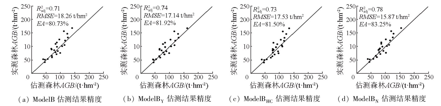
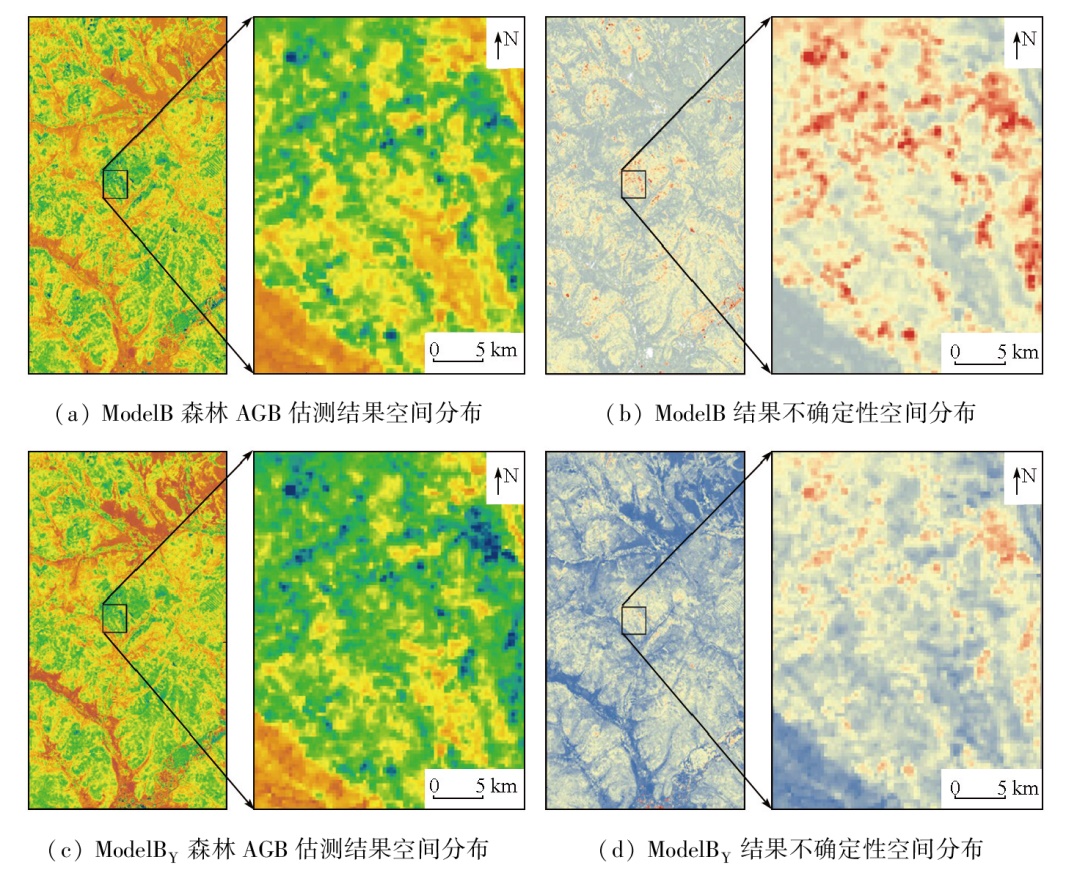
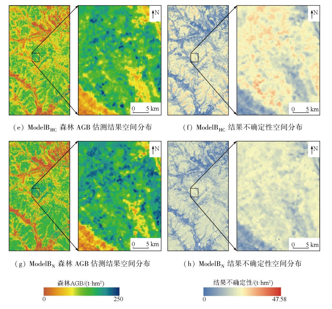
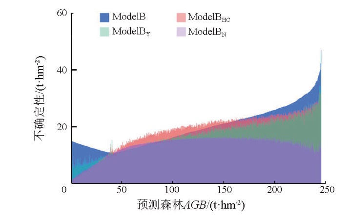
Forest aboveground biomass (AGB) serves as a significant indicator for monitoring forest resources and a crucial part of forest carbon stock. AGB estimation methods, characterized by simple models and physical significance, play a significant role in improving the monitoring efficiency of forest resources. Based on previous studies, this study proposed an allometric model method for AGB estimation by integrating the height features and forest canopy closure derived from the airborne light detection and ranging (LiDAR), and the vegetation indice derived from satellite multispectral data (also referred to as ModelBN). This study investigated Genhe City in Inner Mongolia using LiDAR data and Sentinel-2A multispectral data acquired in 2022, combined with sample plot data obtained around this period. By comparatively analyzing the correlations of LiDAR-derived height features and vegetation indices with AGB, this study applied optimal LiDAR-derived height features and vegetation indices to ModelBN. Finally, this model was compared with models using only height features (ModelB), integrating both height features and vegetation indices (ModelBY), and combining height features and canopy closure (ModelBHC). The results indicate that among the LiDAR-derived height features, the 90th height percentile (H90) exhibited the highest correlation with AGB in the study area. Among the vegetation indices, the kernel normalized difference vegetation index manifested the highest correlation with AGB. Among the four models, the ModelBN achieved the highest adjusted R-square value (, 0.78), the highest estimation accuracy (EA, 83.25 %), and the lowest root mean square error (RMSE, 15.87 t/m2). The ModelBN outperformed the ModelBHC, with improvements in value and EA by 0.05 and 1.75 %, respectively, and a reduction in RMSE by 1.66 t/hm2. The ModelBY outperformed the ModelB, with improvements in value and EA by 0.03 and 1.19 %, respectively, and a reduction in RMSE by 1.12 t/hm2. These results demonstrate the rationality of using vegetation indices as an exponential power. Despite the failure to possess the lowest uncertainty in all pixels, the ModelBN showed the optimal performance. Overall, the ModelBN demonstrates the highest accuracy, a simple and efficient process, and certain physical significance. Therefore, the ModelBN can function as a novel technique for AGB estimation to provide technical support for forest resource monitoring.
Le Toan T, Quegan S, Davidson M W J, et al. The BIOMASS mission:Mapping global forest biomass to better understand the terrestrial carbon cycle[J]. Remote Sensing of Environment, 2011, 115(11):2850-2860.
[2]
Chirici G, McRoberts R E, Fattorini L, et al. Comparing echo-based and canopy height model-based metrics for enhancing estimation of forest aboveground biomass in a model-assisted framework[J]. Remote Sensing of Environment, 2016,174:1-9.
Dong L H, Li F R. Stand-level biomass estimation models for the tree layer of main forest types in East Daxing’an Mountains,China[J]. Chinese Journal of Applied Ecology, 2018, 29(9):2825-2834.
doi: 10.13287/j.1001-9332.201809.014
Lou X T, Zeng Y, Wu B F. Advances in the estimation of above-ground biomass of forest using remote sensing[J]. Remote Sensing for Land and Resources, 2011, 23(1):1-8.doi:10.6046/gtzyyg.2011.01.01.
[5]
de Almeida C T, Galvão L S, de Oliveira Cruz e Aragão L E, et al. Combining LiDAR and hyperspectral data for aboveground biomass modeling in the Brazilian Amazon using different regression algorithms[J]. Remote Sensing of Environment, 2019,232:111323.
[6]
Gleason C J, Im J. Forest biomass estimation from airborne LiDAR data using machine learning approaches[J]. Remote Sensing of Environment, 2012,125:80-91.
Pan L, Sun Y J, Wang Y F, et al. Estimation of aboveground biomass in a Chinese fir(Cunninghamia lanceolata)forest combining data of Sentinel-1 and Sentinel-2[J].Journal of Nanjing Forestry University (Natural Sciences Edition), 2020, 44(3):149-156.
[8]
Puliti S, Hauglin M, Breidenbach J, et al. Modelling above-ground biomass stock over Norway using national forest inventory data with ArcticDEM and Sentinel-2 data[J]. Remote Sensing of Environment, 2020,236:111501.
[9]
Du L M, Pang Y, Wang Q, et al. A LiDAR biomass index-based approach for tree- and plot-level biomass mapping over forest farms using 3D point clouds[J]. Remote Sensing of Environment, 2023,290:113543.
[10]
West G B, Brown J H, Enquist B J. A general model for the structure and allometry of plant vascular systems[J]. Nature, 1999, 400(6745):664-667.
Wu F Y, Gao X L, Zhou R, et al. Research on forest biomass and stock volume model based on stand height and canopy density[J]. Forest Resources Management, 2021(2):61-67.
[12]
Alexander C, Korstjens A H, Hill R A. Influence of micro-topography and crown characteristics on tree height estimations in tropical forests based on LiDAR canopy height models[J]. International Journal of Applied Earth Observation and Geoinformation, 2018,65:105-113.
[13]
Chave J, Réjou-Méchain M, Búrquez A, et al. Improved allometric models to estimate the aboveground biomass of tropical trees[J]. Global Change Biology, 2014, 20(10):3177-3190.
doi: 10.1111/gcb.12629
pmid: 24817483
[14]
Tao S L, Labrière N, Calders K, et al. Mapping tropical forest trees across large areas with lightweight cost-effective terrestrial laser scanning[J]. Annals of Forest Science, 2021, 78(4):103.
[15]
Sarrus F, Rameaux J. Application des sciences accessoires et principalement des mathematiques a la physiologie generale[J]. Bull.Acad.R.Méd.Belg., 1839,3:1094-1110.
[16]
Ahmad Anjum S, Xie X Y, Wang L C, et al. Morphological,physiological and biochemical responses of plants to drought stress[J]. African Journal of Agricultural Research, 2011, 6(9):2026-2032.
[17]
Gamon J A, Field C B, Goulden M L, et al. Relationships between NDVI,canopy structure,and photosynthesis in three Californian vegetation types[J]. Ecological Applications, 1995, 5(1):28-41.
[18]
Rouse J, Haas R H, Deering D, et al. Monitoring the vernal advancement and retrogradation (green wave effect) of natural vegetation[R]. Greenbelt,MD,USA, 1974.
[19]
Green E P, Mumby P J, Edwards A J, et al. Estimating leaf area index of mangroves from satellite data[J]. Aquatic Botany, 1997, 58(1):11-19.
[20]
Yang Q L, Su Y J, Hu T Y, et al. Allometry-based estimation of forest aboveground biomass combining LiDAR canopy height attri-butes and optical spectral indexes[J]. Forest Ecosystems, 2022,9:100059.
[21]
Ni-Meister W, Lee S, Strahler A H, et al. Assessing general relationships between aboveground biomass and vegetation structure parameters for improved carbon estimate from lidar remote sensing[J]. Journal of Geophysical Research:Biogeosciences, 2010, 115(G2):G00E11.
[22]
Coomes D A, Dalponte M, Jucker T, et al. Area-based vs tree-centric approaches to mapping forest carbon in Southeast Asian forests from airborne laser scanning data[J]. Remote Sensing of Environment, 2017,194:77-88.
Li C M, Zhang W F, Li Z Y, et al. Retrieval of forest above-ground biomass using multi-source data in Genhe,Inner Mongolia[J]. Journal of Beijing Forestry University, 2016, 38(3):64-72.
Zhang H, Yang Y, Wang B J, et al. Emission characteristics of water-soluble ions in PM2.5 released by forest fuel combustion in Great Xing’an Mountains,Inner Mongolia,China[J]. Chinese Journal of Applied Ecology, 2021, 32(7):2316-2324.
Li X T, Qin X L, Liu Q, et al. An identification method on forest fuel types based on AISA eagle Ⅱ hyperspectral data[J]. Remote Sensing Technology and Application, 2021, 36(3):544-551,570.
Zhou G Y, Yin G C, Tang X L, et al. Carbon storage-biomass equation of forest ecosystem in China[M]. Beijing: Science Press, 2018:58-60.
[27]
Pang Y, Li Z Y, Ju H B, et al. LiCHy:The CAF’s LiDAR,CCD and hyperspectral integrated airborne observation system[J]. Remote Sensing, 2016, 8(5):398.
[28]
McGaughey R J. FUSION/LDV:Software for LiDAR data analysis and visualization,January 2021-FUSION Version 4.20[EB/OL]. United stated of Department of Agriculture,Washington D C,2021. http://forsys.cfr.washington.edu/software/fusion/FUSION_manual.pdf(accessed16.6.2021).
Cao L, Xu T, Shen X, et al. Mapping biomass by integrating Landsat OLI and airborne LiDAR transect data in subtropical forests[J]. Journal of Remote Sensing, 2016, 20(4):665-678.
[30]
Donoghue D N M, Watt P J, Cox N J, et al. Remote sensing of species mixtures in conifer plantations using LiDAR height and intensity data[J]. Remote Sensing of Environment, 2007, 110(4):509-522.
[31]
Shoko C, Mutanga O. Examining the strength of the newly-launched Sentinel 2 MSI sensor in detecting and discriminating subtle differences between C3 and C4 grass species[J]. ISPRS Journal of Photogrammetry and Remote Sensing, 2017,129:32-40.
[32]
Richardson A J, Wiegand C L. Distinguishing vegetation from soil background information[J]. Photogrammetric Engineering and Remote Sensing, 1977,43:1541-1552
[33]
Liu H Q, Huete A. A feedback based modification of the NDVI to minimize canopy background and atmospheric noise[J]. IEEE Transactions on Geoscience and Remote Sensing, 1995, 33(2):457-465.
[34]
Jordan C F. Derivation of leaf-area index from quality of light on the forest floor[J]. Ecology, 1969, 50(4):663-666.
[35]
Huete A R. A soil-adjusted vegetation index (SAVI)[J]. Remote Sensing of Environment, 1988, 25(3):295-309.
[36]
Camps-Valls G, Campos-Taberner M, Moreno-Martínez Á, et al. A unified vegetation index for quantifying the terrestrial biosphere[J]. Science Advances, 2021, 7(9):eabc7447.
[37]
Ma Q, Su Y J, Luo L P, et al. Evaluating the uncertainty of Landsat-derived vegetation indices in quantifying forest fuel treatments using bi-temporal LiDAR data[J]. Ecological Indicators, 2018,95:298-310.
[38]
Gram J P. Om Konstruktion af Normal-Tilvæxtoversigter,med særligt Hensyn til Iagttagelserne fra Odsherred.Tidsskr[J]. Skovbrug, 1879,3:207-270.
[39]
Hill A, Buddenbaum H, Mandallaz D. Combining canopy height and tree species map information for large-scale timber volume estimations under strong heterogeneity of auxiliary data and variable sample plot sizes[J]. European Journal of Forest Research, 2018, 137(4):489-505.
[40]
Eggleston L, Buendia K, Miwa T. et al. 2006 IPCC guidelines for national greenhouse gas inventories,volume 4:Agriculture,forestry and other land use[J/OL]. Institute for Global Environmental Strategies, 2006. http://www.ipcc-nggip.iges.or.jp/public/2006gl/index.html.
[41]
Saarela S, Wästlund A, Holmström E, et al. Mapping aboveground biomass and its prediction uncertainty using LiDAR and field data,accounting for tree-level allometric and LiDAR model errors[J]. Forest Ecosystems, 2020,7:43.
[42]
McRoberts R E, Næsset E, Hou Z Y, et al. How many bootstrap replications are necessary for estimating remote sensing-assisted,model-based standard errors?[J]. Remote Sensing of Environment, 2023,288:113455.
[43]
Saarela S, Schnell S, Grafström A, et al. Effects of sample size and model form on the accuracy of model-based estimators of growing stock volume[J]. Canadian Journal of Forest Research, 2015, 45(11):1524-1534.
[44]
Snowdon P. A ratio estimator for bias correction in logarithmic regressions[J]. Canadian Journal of Forest Research, 1991, 21(5):720-724.
[45]
Schober P, Boer C, Schwarte L A. Correlation coefficients:Appropriate use and interpretation[J]. Anesthesia and Analgesia, 2018, 126(5):1763-1768.
[46]
Guerini Filho M, Kuplich T M, De Quadros F L F. Estimating natural grassland biomass by vegetation indices using Sentinel 2 remote sensing data[J]. International Journal of Remote Sensing, 2020, 41(8):2861-2876.
[47]
Frazer G W, Magnussen S, Wulder M A, et al. Simulated impact of sample plot size and co-registration error on the accuracy and uncertainty of LiDAR-derived estimates of forest stand biomass[J]. Remote Sensing of Environment, 2011, 115(2):636-649.
[48]
Labrière N, Tao S L, Chave J, et al. In situ reference datasets from the TropiSAR and AfriSAR campaigns in support of upcoming spaceborne biomass missions[J]. IEEE Journal of Selected Topics in Applied Earth Observations and Remote Sensing, 2018, 11(10):3617-3627.
[49]
Duncanson L, Kellner J R, Armston J, et al. Aboveground biomass density models for NASA’s Global Ecosystem Dynamics Investigation (GEDI) lidar mission[J]. Remote Sensing of Environment, 2022,270:112845.
[50]
Cushman K C, Saatchi S, McRoberts R E, et al. Small field plots can cause substantial uncertainty in gridded aboveground biomass products from airborne lidar data[J]. Remote Sensing, 2023, 15(14):3509.
[51]
Puliti S, Saarela S, Gobakken T, et al. Combining UAV and Sentinel-2 auxiliary data for forest growing stock volume estimation through hierarchical model-based inference[J]. Remote Sensing of Environment, 2018,204:485-497.
[52]
Gong H D, Cheng Q P, Jin H Y, et al. Effects of temporal,spatial,and elevational variation in bioclimatic indices on the NDVI of different vegetation types in Southwest China[J]. Ecological Indicators, 2023,154:110499.
[53]
Maxwell S K, Sylvester K M. Identification of “ever-cropped” land (1984—2010) using Landsat annual maximum NDVI image composites:Southwestern Kansas case study[J]. Remote Sensing of Environment, 2012,121:186-195.
[54]
Korhonen L, Korpela I, Heiskanen J, et al. Airborne discrete-return LIDAR data in the estimation of vertical canopy cover,angular ca-nopy closure and leaf area index[J]. Remote Sensing of Environment, 2011, 115(4):1065-1080.
[55]
Ma Q, Su Y J, Guo Q H. Comparison of canopy cover estimations from airborne LiDAR,aerial imagery,and satellite imagery[J]. IEEE Journal of Selected Topics in Applied Earth Observations and Remote Sensing, 2017, 10(9):4225-4236.
 2025, Vol. 37
  ), 陈尔学1,2,3(