|
|
|
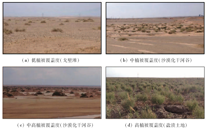
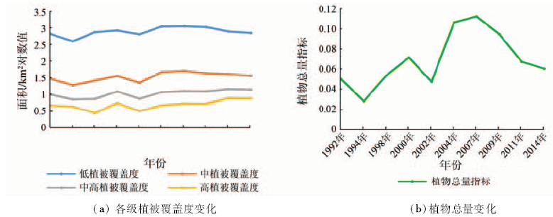
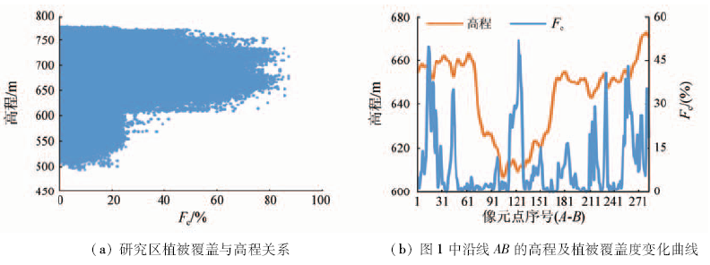
Abstract The Dananhu district in Hami of Xinjiang is a typical gobi desert in Northwest China. In this paper, the authors investigated the temporal-spatial variations of the natural vegetation coverage during 1992―2014 in this region, using correlation analyses and dimidiate pixel model based on the multi-spectral remote sensing data, the local meteorological data, and the digital elevation model. The results show that, from 1992 to 2014, vegetation coverage in the region showed a trend of increase. Generally the vegetation coverage is weakly positively correlated to elevation; locally, however, the plants (mainly juniper tamarisk, haloxylon ammodendron, and reed) are more developed in the relatively depressed localities (saline areas or sandy dry riverbeds) than those in Gobi desert areas. The vegetation coverage is positively correlated to the sunshine duration and evaporation, but unrelated to precipitation and humidity. It is suggested that the natural plants in this regions live on groundwater mainly. The global temperature increasing during 1992-2014 might to some extent promote, instead of retard, the natural vegetation, probably through enhancing the groundwater supply due to glacier melting at nearby mountains.
|
| Keywords
Dananhu in Hami
Xinjiang
remote sensing
vegetation coverage
Gobi desert
climate change
|
|
|
|
Issue Date: 08 February 2018
|
|
|
| [1] |
贾坤,姚云军,魏香琴,等.植被覆盖度遥感估算研究进展[J].地球科学进展,2013,28(7):774-782.
|
| [1] |
Jia K,Yao Y J,Wei X Q,et al.A review on fractional vegetation cover estimation using remote sensing[J].Advances in Earth Science,2013,28(7):774-782.
|
| [2] |
Jones C,Lowe J,Liddicoat S,et al.Committed terrestrial ecosystem changes due to climate change[J].Nature Geoscience,2009,2(7):484-487.
|
| [3] |
Steffen W,Sanderson A,Tyson P D,et al.Global Change and the Earth System:A planet under Pressure[M].Berlin Heidelberg:Springer,2004.
|
| [4] |
李向婷,白洁,李光录,等.新疆荒漠稀疏植被覆盖度信息遥感提取方法比较[J].干旱区地理,2013,36(3):502-511.
|
| [4] |
Li X T,Bai J,Li G L,et al.Comparison of methods based on MODIS for estimating sparse vegetation fraction across desert in Xinjiang[J].Arid Land Geography,2013,36(3):502-511.
|
| [5] |
罗新平,江泽平,张大华,等.论干旱区森林可持续经营中的林牧关系[J].世界林业研究,1999,12(3):29-33.
|
| [5] |
Luo X P,Jiang Z P,Zhang D H,et al.Forest grazing for sustainable forest management in arid zones[J].World Forestry Research,1999,12(3):29-33.
|
| [6] |
祝稳. 西北干旱区植被覆盖动态及其对极端气温和降水过程的响应[D].兰州:西北师范大学,2015.
|
| [6] |
Zhu W.Spatial-Temporal Dynamics of Vegetation Coverage and Its Response to Extreme Temperature and Precipitation Processes Over the Arid Region of Northwest China[D].Lanzhou:Northwest Normal University,2015.
|
| [7] |
Nemani R R,Keeling C D,Hashimoto H,et al.Climate-driven increases in global terrestrial net primary production from 1982 to 1999[J].Science,2003,300(5625):1560-1563.
|
| [8] |
徐浩杰. 亚洲中部干旱区植被变化及其影响因素(2000―2012)[D].兰州:兰州大学,2014.
|
| [8] |
Xu H J.Variations of Vegetation and Its Influence Factors in the Arid Region of the Central Asia from 2000 to 2012[D].Lanzhou:Lanzhou University,2014.
|
| [9] |
Purevdorj T S,Tateishi R,Ishiyama T,et al.Relationships between percent vegetation cover and vegetation indices[J].International Journal of Remote Sensing,1998,19(18):3519-3535.
|
| [10] |
Gitelson A A,Stark R,Grits U,et al.Vegetation and soil lines in visible spectral space:A concept and technique for remote estimation of vegetation fraction[J].International Journal of Remote Sensing,2002,23(13):2537-2562.
|
| [11] |
章文波,符素华,刘宝元.目估法测量植被覆盖度的精度分析[J].北京师范大学学报(自然科学版),2001,37(3):402-408.
|
| [11] |
Zhang W B,Fu S H,Liu B Y.Error assessment of visual estimation plant coverage[J].Journal of Beijing Normal University(Natural Science),2001,37(3):402-408.
|
| [12] |
武正丽,贾文雄,刘亚荣,等.近10a来祁连山植被覆盖变化研究[J].干旱区研究,2014,31(1):80-87.
|
| [12] |
Wu Z L,Jia W X,Liu Y R,et al.Change of vegetation coverage in the Qilian mountains in recent 10 years[J].Arid Zone Research,2014,31(1):80-87.
|
| [13] |
陈效逑,王恒.1982―2003年内蒙古植被带和植被覆盖度的时空变化[J].地理学报,2009,64(1):84-94.
|
| [13] |
Chen X Q,Wang H.Spatial and temporal variations of vegetation belts and vegetation cover degrees in Inner Mongolia from 1982 to 2003[J].Acta Geographica Sinica,2009,64(1):84-94.
|
| [14] |
李苗苗,吴炳方,颜长珍,等.密云水库上游植被覆盖度的遥感估算[J].资源科学,2004,26(4):153-159.
|
| [14] |
Li M M,Wu B F,Yan C Z,et al.Estimation of vegetation fraction in the upper basin of Miyun reservoir by remote sensing[J].Resources Science,2004,26(4):153-159.
|
| [15] |
Goward S N,Tucker C J,Dye D G.North American vegetation patterns observed with the NOAA-7 advanced very high resolution radiometer[J].Vegetatio,1985,64(1):3-14.
|
| [16] |
Qi J,Marsett R C,Moran M S,et al.Spatial and temporal dynamics of vegetation in the San Pedro River basin area[J].Agricultural and Forest Meteorology,2000,105(1/3):55-68.
|
| [17] |
刘广峰,吴波,范文义,等.基于像元二分模型的沙漠化地区植被覆盖度提取——以毛乌素沙地为例[J].水土保持研究,2007,14(2):268-271.
|
| [17] |
Liu G F,Wu B,Fan W Y,et al.Extraction of vegetation coverage in desertification regions based on the dimidiate pixel model:A case study in Maowusu sandland[J].Research of Soil and Water Conservation,2007,14(2):268-271.
|
| [18] |
李晓松. 干旱地区稀疏植被覆盖度高光谱遥感定量反演研究[D].北京:中国林业科学研究院,2008.
|
| [18] |
Li X S.Quantitative Retrieval of Sparse Vegetation Cover in Arid Regions Using Hyperspectral Data[D].Beijing:Chinese Academy of Forestry,2008.
|
| [19] |
师庆东,王智,贺龙梅,等.基于气候、地貌、生态系统的景观分类体系——以新疆地区为例[J].生态学报,2014,34(12):3359-3367.
|
| [19] |
Shi Q D,Wang Z,He L M,et al.Landscape classification system based on climate, landform,ecosystem:A case study of Xinjiang area[J].Acta Ecologica Sinica,2014,34(12):3359-3367.
|
| [20] |
孙洪波,王让会,张慧芝,等.新疆山地—绿洲—荒漠系统及其气候特征[J].干旱区地理,2005,28(2):199-204.
|
| [20] |
Sun H B,Wang R H,Zhang H Z,et al.Mountain-oasis-desert system and characteristics of climate in Xinjiang[J].Arid Land Geography,2005,28(2):199-204.
|
| [21] |
沈霞. 新疆哈密南湖流域环境变化分析[D].西安:陕西师范大学,2008.
|
| [21] |
Shen X.The Analysis of Nanhu River Basin Environmental Change in Hami,Xinjiang[D].Xi’an:Shaanxi Normal University,2008.
|
| [22] |
穆少杰,李建龙,陈奕兆,等.2001―2010年内蒙古植被覆盖度时空变化特征[J].地理学报,2012,67(9):1255-1268.
|
| [22] |
Mu S J,Li J L,Chen Y Z,et al.Spatial differences of variations of vegetation coverage in Inner Mongolia during 2001―2010[J].Acta Geographica Sinica,2012,67(9):1255-1268.
|
| [23] |
李玉霞. 岷江上游毛儿盖地区生态水信息指标参数遥感量化研究[D].成都:成都理工大学,2007.
|
| [23] |
Li Y X.Quantitative Study of Eco-Water Information Indices Based on Remote Sensing Images in Maoergai District of Upper Minjiang River[D].Chengdu:Chengdu University of Technology,2007.
|
| [24] |
黎良财,邓利,曹颖,等.基于NDVI像元二分模型的矿区植被覆盖动态监测[J].中南林业科技大学学报,2012,32(6):18-23.
|
| [24] |
Li L C,Deng L,Cao Y,et al.Vegetation dynamic monitoring in mining area based on NDVI serial images and dimidiate pixel model[J].Journal of Central South University of Forestry & Technology,2012,32(6):18-23.
|
| [25] |
马宗义. 基于TM影像的沙漠化信息定量提取方法[D].兰州:兰州大学,2013.
|
| [25] |
Ma Z Y.Quantitative Method for Extracting of Desertification Information Based on TM Image[D].Lanzhou:Lanzhou University,2013.
|
| [26] |
田庆久,闵祥军.植被指数研究进展[J].地球科学进展,1998,13(4):327-333.
|
| [26] |
Tian Q J,Min X J.Advances in study on vegetation indices[J].Advance in Earth Sciences,1998,13(4):327-333.
|
| [27] |
龙晓闽,周忠发,张会,等.基于NDVI像元二分模型植被覆盖度反演喀斯特石漠化研究——以贵州毕节鸭池示范区为例[J].安徽农业科学,2010,38(8):4184-4186.
|
| [27] |
Long X M,Zhou Z F,Zhang H,et al.Study on Karst rock-desertification of extracting vegetation coverage inversion based on NDVI serial images and dimidiate pixel model:A case study of Yachi demonstration area of Guizhou[J].Journal of Anhui Agricultural Sciences,2010,38(8):4184-4186.
|
| [28] |
叶娇珑,何政伟,翁中银,等.NDVI像元二分模型在喀斯特地区提取石漠化中的应用[J].地理空间信息,2012,10(4):134-136.
|
| [28] |
Ye J L,He Z W,Weng Z Y,et al.Application of NDVI pixel binary model in extraction of rocky desertification in Karst areas[J].Geospatial Information,2012,10(4):134-136.
|
| [29] |
中国气象局.生态质量气象评价规范(试行)[S].北京:气象出版社,2005.
|
| [29] |
China Meteorological Administration.Standard for meteorological evaluation of ecological quality[S].Beijing:China Meteorological Press,2005.
|
| [30] |
徐建华. 现代地理学中的数学方法[M].北京:高等教育出版社,2002.
|
| [30] |
Xu J H.Mathematical Methods in Contemporary Geography[M].Beijing:Higher Education Press,2002.
|
| [31] |
严丽坤. 相关系数与偏相关系数在相关分析中的应用[J].云南财贸学院学报,2003,19(3):78-80.
|
| [31] |
Yan L K.Application of correlation coefficient and biased correlation coefficient in related analysis[J].Journal of Yunnan University of Finance and Economics,2003,19(3):78-80.
|
| [32] |
吴越. 吐鲁番盆地地表蒸散量估算与植被演化特征研究[D].北京:中国地质大学(北京),2013.
|
| [32] |
Wu Y.The Evapotranspiration Estimation and Evolution Characteristics of Vegetation in Turpan Basin[D].Beijing:China University of Geosciences(Beijing),2013.
|
| [33] |
高建芳,骆光晓.气候变化对新疆哈密地区河川径流的影响分析[J].冰川冻土,2009,31(4):748-758.
|
| [33] |
Gao J F,Luo G X.Analysis of the impact of climate changes on river’s runoff in Hami prefecture, Xinjiang[J].Journal of Glaciology and Geocryology,2009,31(4):748-758.
|
| [34] |
Zhao M S,Running S W.Drought-induced reduction in global terrestrial net primary production from 2000 through 2009[J].Science,2010,329(5994):940-943.
|
|
Viewed |
|
|
|
Full text
|
|
|
|
|
Abstract
|
|
|
|
|
Cited |
|
|
|
|
| |
Shared |
|
|
|
|
| |
Discussed |
|
|
|
|
 2018,
Vol. 30
2018,
Vol. 30
 ), Zhenfei ZHANG1(