|
|
 |
|

|
|
|
Road extraction by incremental Markov random field segmentation from high spatial resolution remote sensing images |
| Ye LYU, Xiangyun HU |
| School of Remote Sensing and Engineering, Wuhan University, Wuhan 430072, China |
|
|
|
|
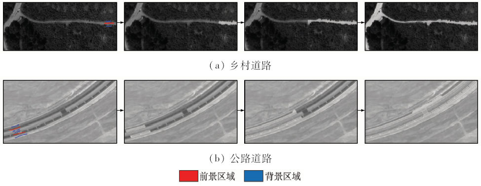
Abstract Remote sensing technology has been the most effective and efficient method for extracting information from the earth surface. Roads in the high spatial resolution remote sensing images are areas with very complex road features. None road objects, such as cars, lanes and pedestrians, will change road appearance greatly, which makes road extraction difficult. The authors take advantage of Gaussian mixture model and Markov random field, which adapts to interference, to evaluate foreground and background models and label their pixels. As roads go through the remote sensing images, the areas far from the roads are useless for road extraction, and hence local incremental segmentation method takes effect. The experiments show that methods used in this paper are fairly effective.
|
| Keywords
Markov random field
incremental segmentation
road extraction
remote sensing images
high spatial resolution
|
|
|
|
Issue Date: 10 September 2018
|
|
|
| [1] |
Lyu Y, Wang G F, Hu X Y.Machine learning based road detection from high resolution imagery[J].ISPRS-International Archives of the Photogrammetry, Remote Sensing and Spatial Information Sciences, 2016, XLI-B3:891-898.
doi: 10.5194/isprs-archives-XLI-B3-891-2016
url: http://adsabs.harvard.edu/abs/2016ISPAr41B3..891L
|
| [2] |
Vosselman G, Knecht J D . Road Tracing by Profile Matching and Kaiman Filtering[M] //Gruen A,Kuebler O,Agouris P.Automatic Extraction of Man-Made Objects from Aerial and Space Images.Monte Verità:Birkhäuser Basel, 1995: 265-274.
|
| [3] |
Singh P P, Garg R D . Automatic road extraction from high resolution satellite image using adaptive global thresholding and morphological operations[J]. Journal of the Indian Society of Remote Sensing, 2013,41(3):631-640.
doi: 10.1007/s12524-012-0241-4
url: http://link.springer.com/10.1007/s12524-012-0241-4
|
| [4] |
Cheng J H, Guan Y F, Ku X S, et al. Semi-automatic road centerline extraction in high-resolution SAR images based on circular template matching [C]//Proceedings of 2011 International Conference on Electric Information and Control Engineering.Wuhan,China:IEEE, 2011: 1688-1691.
|
| [5] |
Hu Y, Zu K J. Road extraction from remote sensing imagery based on road tracking and ribbon snake [C]//Proceedings of 2009 Pacific-Asia Conference on Knowledge Engineering and Software Engineering.Shenzhen,China:IEEE, 2009: 201-204.
|
| [6] |
Sujatha C, Selvathi D . Connected component-based technique for automatic extraction of road centerline in high resolution satellite images[J]. EURASIP Journal on Image and Video Processing, 2015,2015(1):8.
doi: 10.1186/s13640-015-0062-9
url: https://jivp-eurasipjournals.springeropen.com/articles/10.1186/s13640-015-0062-9
|
| [7] |
Song M J, Civco D . Road extraction using SVM and image segmentation[J]. Photogrammetric Engineering and Remote Sensing, 2004,70(12):1365-1371.
doi: 10.14358/PERS.70.12.1365
url: http://openurl.ingenta.com/content/xref?genre=article&issn=0099-1112&volume=70&issue=12&spage=1365
|
| [8] |
Sirmacek B, Unsalan C. Road network extraction using edge detection and spatial voting [C]//Proceedings of the 20th International Conference on Pattern Recognition.Istanbul,Turkey:IEEE, 2010: 3113-3116.
|
| [9] |
Bicego M, Dalfini S, Vernazza G , et al.Automatic road extraction from aerial images by probabilistic contour tracking[C]//Proceedings of 2003 International Conference on Image Processing. Barcelona,Spain:IEEE,2003:III-585-8.
|
| [10] |
Gamba P, Dell’Acqua F,Lisini G.Improving urban road extraction in high-resolution images exploiting directional filtering,perceptual grouping,and simple topological concepts[J]. IEEE Geoscience and Remote Sensing Letters, 2006,3(3):387-391.
doi: 10.1109/LGRS.2006.873875
url: http://ieeexplore.ieee.org/document/1658011/
|
| [11] |
Wang Y Q, Tian Y, Tai X Q, et al. Extraction of main urban roads from high resolution satellite images by machine learning [C]//Proceedings of the 7th Asian Conference on Computer Vision.Hyderabad,India:Springer, 2006: 236-245.
|
| [12] |
Chen Y H, Su W, Li J , et al. Hierarchical object oriented classification using very high resolution imagery and LiDAR data over urban areas[J]. Advances in Space Research, 2009,43(7):1101-1110.
doi: 10.1016/j.asr.2008.11.008
url: http://linkinghub.elsevier.com/retrieve/pii/S0273117708005735
|
| [13] |
Hinz S, Baumgartner A, Steger C , et al. Road extraction in rural and urban areas[J]. Semantic Modeling for the Acquisition of Topographic Information from Images and Maps, 1999,4:133-153.
url: http://ci.nii.ac.jp/naid/10015229207
|
| [14] |
Boykov Y Y, Jolly M P. Interactive graph cuts for optimal boundary & region segmentation of objects in N-D images [C]//Proceedings of the 8th IEEE International Conference on Computer Vision.Vancouver,BC,Canada:IEEE, 2001,1:105-112.
|
| [15] |
Ruzon M A, Tomasi C. Alpha estimation in natural images [C]//Proceedings of 2000 IEEE Conference on Computer Vision and Pattern Recognition.Hilton Head Island,SC,USA:IEEE, 2000,1:18-25.
|
| [16] |
Kernighan B W, Lin S . An efficient heuristic procedure for partitioning graphs[J]. The Bell System Technical Journal, 1970,49(2):291-307.
doi: 10.1002/bltj.1970.49.issue-2
url: http://doi.wiley.com/10.1002/bltj.1970.49.issue-2
|
| [17] |
Achanta R, Hemami S, Estrada F, et al. Frequency-tuned salient region detection [C]//Proceedings of 2009 IEEE Conference on Computer Vision and Pattern Recognition.Miami,FL,USA:IEEE, 2009: 1597-1604.
|
| [18] |
Cheng M M, Mitra N J, Huang X L , et al. Global contrast based salient region detection[J]. IEEE Transactions on Pattern Analysis and Machine Intelligence, 2015,37(3):569-582.
doi: 10.1109/TPAMI.2014.2345401
pmid: 26353262
url: http://ieeexplore.ieee.org/document/6871397/
|
| [19] |
Tang M, Gorelick L, Veksler O, et al. GrabCut in one cut [C]//Proceedings of 2003 IEEE International Conference on Computer Vision.Sydney,NSW,Australia:IEEE, 2013: 1769-1776.
|
| [20] |
Cheng M M, Prisacariu V A, Zheng S , et al. DenseCut:densely connected CRFs for realtime grabCut[J]. Computer Graphics Forum, 2015,34(7):193-201.
doi: 10.1111/cgf.12758
url: http://dl.acm.org/citation.cfm?id=2851399
|
|
Viewed |
|
|
|
Full text
|
|
|
|
|
Abstract
|
|
|
|
|
Cited |
|
|
|
|
| |
Shared |
|
|
|
|
| |
Discussed |
|
|
|
|
 2018,
Vol. 30
2018,
Vol. 30