|
|
 |
|

|
|
|
Application of intensity analysis theory in the land use change in Yijin Holo Banner under the background of coal mining |
SANG Xiao1( ), ZHANG Chengye1,2, LI Jun1,2(), ZHU Shoujie1, XING Jianghe1, WANG Jinyang1, WANG Xingjuan1, LI Jiayao1, YANG Ying1 ), ZHANG Chengye1,2, LI Jun1,2(), ZHU Shoujie1, XING Jianghe1, WANG Jinyang1, WANG Xingjuan1, LI Jiayao1, YANG Ying1 |
1. College of Geoscience and Surveying Engineering, China University of Mining and Technology-Beijing, Beijing 100083,China
2. State Key Laboratory of Coal Resources and Safe Mining, China University of Mining and Technology-Beijing, Beijing 100083,China |
|
|
|
|
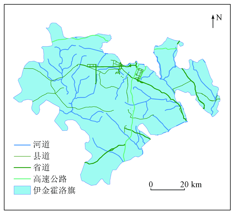
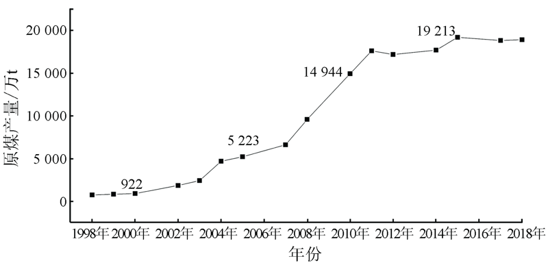
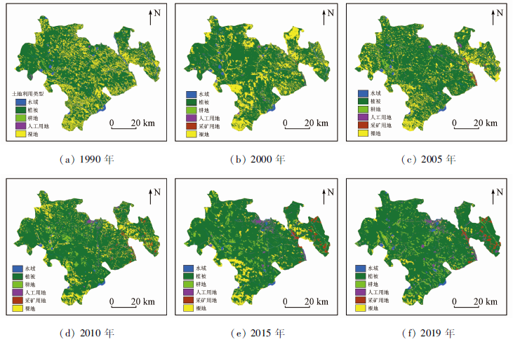
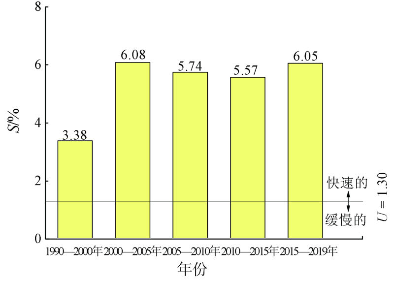
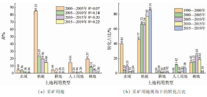
Abstract This study aims to explore the differences and characteristics of the impacts of coal mining activities at different stages on various land use types in mining areas. Taking Yijin Huoluo Banner-a major coal-producing area in China-as the study area and multi-stage Landsat remote sensing images of nearly 30 years during 1990-2019 as the main data source, this study extracted land use distribution information using the random forest classification method on the Google Earth Engine platform. Based on this as well as coal mining statistical data, this paper analyzed the characteristics of land use changes at three stages of coal mining using the intensity analysis theory. The results are as follows. ① The intensity change theory can be used to comprehensively analyze the land use change from the aspects of intervals, categories, and transformation and to more systematically exhibit the characteristics of land use changes and the impacts of human activities in the study area. These are greatly significant for the in-depth understanding of the land use change process. ② Coal mining produces different impacts on different types of land, and it primarily affects the vegetation, water areas, and bare land. ③ Coal mining imposes different impacts on various types of land at different stages. It produces slight impacts on various types of land at the initial stage. It produces increasing impacts on various types of land at the high-speed development stage, during which it mainly affects vegetation, bare land, and water areas in and around the mining area. Then the impacts decrease at the steady development stage of coal mining. The results of this study can serve the implementation of precise protection plans for different types of land at different coal mining stages and provide a scientific basis for the protection of the ecological environment in the mining area.
|
| Keywords
coal mining
Landsat remote sensing images
land use change
intensity analysis theory
|
|
|
|
Corresponding Authors:
LI Jun
E-mail: sangxiao@student.cumtb.edu.cn;junli@cumtb.edu.cn
|
|
Issue Date: 24 September 2021
|
|
|
| [1] |
Liu J, Yang T, Wang L, et al. Research progress in coal and gas co-mining modes in China[J]. Energy Science and Engineering, 2020, 8:3365-3376.
doi: 10.1002/ese3.v8.9
url: https://onlinelibrary.wiley.com/toc/20500505/8/9
|
| [2] |
Wang G F, Xu Y X, Ren H W. Intelligent and ecological coal mining as well as clean utilization technology in China:Review and prospects[J]. International Journal of Mining Science and Technology, 2019, 29:161-169.
doi: 10.1016/j.ijmst.2018.06.005
url: https://linkinghub.elsevier.com/retrieve/pii/S2095268617307334
|
| [3] |
Zhang M, Wang J M, Li S J, et al. Dynamic changes in landscape pattern in a large-scale opencast coal mine area from 1986 to 2015:A complex network approach[J]. Catena, 2020(194):104738.
|
| [4] |
Gorokhovich Y, Reid M, Mignone E, et al. Prioritizing abandoned coal mine reclamation projects within the contiguous United States using geographic information system extrapolation[J]. Environmental Management, 2003, 32(4):527-534.
pmid: 14986901
|
| [5] |
Qian D, Yan C, Xing Z, et al. Monitoring coal mine changes and their impact on landscape patterns in an alpine region:A case study of the Muli coal mine in the Qinghai-Tibet Plateau[J]. Environmental Monitoring and Assessment, 2017, 189(11),559-570.
doi: 10.1007/s10661-017-6284-9
url: http://link.springer.com/10.1007/s10661-017-6284-9
|
| [6] |
战甜. 霍林河南露天矿土地利用与景观格局变化研究[D]. 呼和浩特:内蒙古农业大学, 2017.
|
| [6] |
Zhan T. Study on land use and landscape pattern change in Huolinhenan open-pit coal mine[D]. Hohhot:Inner Mongolia Agricultural University, 2017.
|
| [7] |
Feng Y, Wang J, Bai Z, et al. Effects of surface coal mining and land reclamation on soil properties:A review[J]. Earth-Science Reviews, 2019(191):12-25.
|
| [8] |
Li J, Pei Y Q, Zhao S H, et al. A review of remote sensing for environmental monitoring in China[J]. Remote Sensing, 2020, 12(7):1130.
doi: 10.3390/rs12071130
url: https://www.mdpi.com/2072-4292/12/7/1130
|
| [9] |
Zhang M, Wang J M, Feng Y. Temporal and spatial change of land use in a large-scale opencast coal mine area:A complex network approach[J]. Land Use Policy, 2019, 86:375-386.
doi: 10.1016/j.landusepol.2019.05.020
|
| [10] |
Rendenieks Z, Nita M D, Nikodemus O, et al. Half a century of forest cover change along the Latvian-Russian border captured by object-based image analysis of Corona and Landsat TM/OLI data[J]. Remote Sensing of Environment, 2020, 249:112010.
doi: 10.1016/j.rse.2020.112010
url: https://linkinghub.elsevier.com/retrieve/pii/S0034425720303801
|
| [11] |
Negri R G, da Silva E A, Casaca W. Inducing contextual classifications with kernel functions into support vector machines[J]. IEEE Geoscience and Remote Sensing Letters, 2018, 15(6):962-966.
doi: 10.1109/LGRS.2018.2816460
url: https://ieeexplore.ieee.org/document/8329996/
|
| [12] |
Berhane T M, Lane C R, Wu Q S, et al. Decision-tree,rule-based,and random forest classification of high-resolution multispectral imagery for wetland mapping and inventory[J]. Remote Sensing, 2018, 10(4):580.
doi: 10.3390/rs10040580
pmid: 30147945
|
| [13] |
Garosi Y, Sheklabadi M, Pourghasemi H R, et al. Comparison of differences in resolution and sources of controlling factors for gully erosion susceptibility mapping[J]. Geoderma, 2018, 330:65-78.
doi: 10.1016/j.geoderma.2018.05.027
url: https://linkinghub.elsevier.com/retrieve/pii/S0016706117322231
|
| [14] |
Alimjan G, Sun T L, Liang Y, et al. A new technique for remote sensing image classification based on combinatorial algorithm of SVM and KNN[J]. International Journal of Pattern Recognition and Artificial Intelligence, 2018, 32(7):1859012.
doi: 10.1142/S0218001418590127
url: https://www.worldscientific.com/doi/abs/10.1142/S0218001418590127
|
| [15] |
Bazi Y, Melgani F. Convolutional SVM networks for object detection in UAV imagery[J]. IEEE Transactions on Geoscience and Remote Sensing, 2018, 56(6):3107-3118.
doi: 10.1109/TGRS.2018.2790926
url: https://ieeexplore.ieee.org/document/8288824/
|
| [16] |
桑潇, 国巧真, 潘应阳, 等. 基于TM和OLI数据山西省潞城市土地利用动态变化分析与预测[J]. 国土资源遥感, 2018, 30(2):125-131.doi: 10.6046/gtzyyg.2018.02.17.
doi: 10.6046/gtzyyg.2018.02.17
|
| [16] |
Sang X, Guo Q Z, Pan Y Y, et al. Research on land use dynamic change and prediction in Lucheng City of Shanxi Province based on TM and OLI[J]. Remote Sensing for Land and Resources, 2018, 30(2):125-131.doi: 10.6046/gtzyyg.2018.02.17.
doi: 10.6046/gtzyyg.2018.02.17
|
| [17] |
Aldwaik S Z Pontius R G J. Intensity analysis to unify measurements of size and stationarity of land changes by interval,category,and transition[J]. Landscape Urban Planning, 2012(106):103-114.
|
| [18] |
孙云华, 郭涛, 崔希民. 昆明市土地利用变化的强度分析与稳定性研究[J]. 地理科学进展, 2016, 35(2):245-254.
doi: 10.18306/dlkxjz.2016.02.011
|
| [18] |
Sun Y H, Guo T, Cui X M. Intensity analysis and stationarity of land use change in Kunming City[J]. Progress in Geography, 2016, 35(2):245-254.
|
| [19] |
Sang X, Guo Q Z, Wu X X, et al. Intensity and stationarity analysis of land use change based on CART algorithm[J]. Scientific Reports, 2019(9):12279.
|
| [20] |
邵亚奎, 王蕾, 朱长明, 等. GEE云平台支持下的西天山森林遥感监测与时空变化分析[J]. 测绘通报, 2020(8):13-17.
|
| [20] |
Shao Y K, Wang L, Zhu C M, et al. Forest survey and spatio-temporal analysis in West Tianshan mountains supported by Google Earth Engine[J]. Bulletin of Surveying and Mapping, 2020(8):13-17.
|
| [21] |
Gong P, Li X C, Wang J, et al. Annual maps of global artificial impervious area (GAIA) between 1985 and 2018[J]. Remote Sensing of Environment, 2020, 236:111510.
doi: 10.1016/j.rse.2019.111510
url: https://linkinghub.elsevier.com/retrieve/pii/S0034425719305292
|
| [22] |
Parente L, Mesquita V, Miziara F, et al. Assessing the pasturelands and livestock dynamics in Brazil,from 1985 to 2017:A novel approach based on high spatial resolution imagery and Google Earth Engine cloud computing[J]. Remote Sensing of Environment, 2019(232):111301.
|
| [23] |
Phan T N, Kuch V, Lehnert L W. Land cover classification using Google Earth Engine and random forest classifier:The role of image composition[J]. Remote Sensing, 2020, 12(15):2411.
doi: 10.3390/rs12152411
url: https://www.mdpi.com/2072-4292/12/15/2411
|
| [24] |
Tassi A, Vizzari M. Object-oriented LULC classification in Google Earth Engine combining SNIC,GLCM,and machine learning algorithms[J]. Remote Sensing, 2020, 12(22):3776.
doi: 10.3390/rs12223776
url: https://www.mdpi.com/2072-4292/12/22/3776
|
| [25] |
Lin L L, Hao Z B, Post C J, et al. Monitoring land cover change on a rapidly urbanizing island using Google Earth Engine[J]. Applied Sciences-Basel, 2020, 10(25):7336.
|
| [26] |
Fashae O A, Adagbasa E G, Olusola A O, et al. Land use/land cover change and land surface temperature of Ibadan and environs,Nigeria[J]. Environmental Monitoring and Assessment, 2020, 192(2):109.
doi: 10.1007/s10661-019-8054-3
url: https://doi.org/10.1007/s10661-019-8054-3
|
| [27] |
董欣, 刘鹏程. 基于GEE的土地利用变化对生态系统服务价值的影响研究——以京津冀地区为例[J]. 华中师范大学学报(自然科学版), 2020, 54(4):670-678.
|
| [27] |
Dong X, Liu P C. Impacts study of GEE-based land use changes on ecosystem service value(ESV):Take the Beijing-Tianjin-Hebei Region as an example[J]. Journal of Central China Normal University (Natural Sciences), 2020, 54(4):670-678.
|
| [28] |
杨可明. 遥感原理与应用[M]. 北京: 中国矿业大学出版社, 2016:231-234.
|
| [28] |
Yang K M. Remote sensing principle and applications[M]. Beijing: China University of Mining and Technology Press, 2016:231-234.
|
| [29] |
Cerrillo R M N, Rodriguez G P, Rumbao I C, et al. Modeling major rural land-use changes using the GIS-based cellular automata metronamica model:The case of andalusia (Southern Spain)[J]. ISPRS International Journal of Geo-Information, 2020, 9(7):458.
doi: 10.3390/ijgi9070458
url: https://www.mdpi.com/2220-9964/9/7/458
|
|
Viewed |
|
|
|
Full text
|
|
|
|
|
Abstract
|
|
|
|
|
Cited |
|
|
|
|
| |
Shared |
|
|
|
|
| |
Discussed |
|
|
|
|
 2021,
Vol. 33
2021,
Vol. 33