|
|
 |
|

|
|
|
Automatic expansion extraction algorithm of remote sensing images |
Li XUE1,2, Shuwen YANG1,2( ), Jijing MA1,2, Xin JIA1,2, Ruliu YAN1,2 ), Jijing MA1,2, Xin JIA1,2, Ruliu YAN1,2 |
1.Faculty of Geomatics, Lanzhou Jiaotong University, Lanzhou 730070, China
2.Gansu Provincial Engineering Laboratory for National Geographic State Monitoring, Lanzhou 730070, China |
|
|
|
|
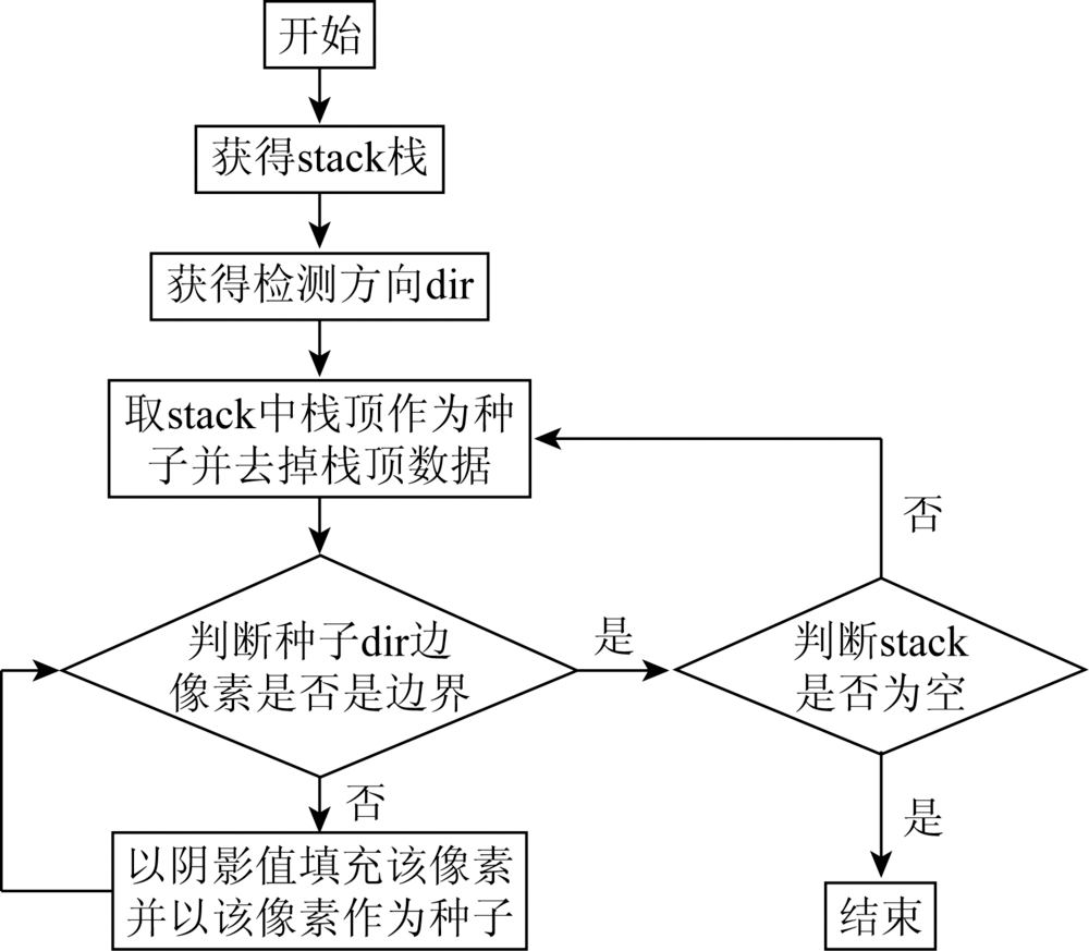
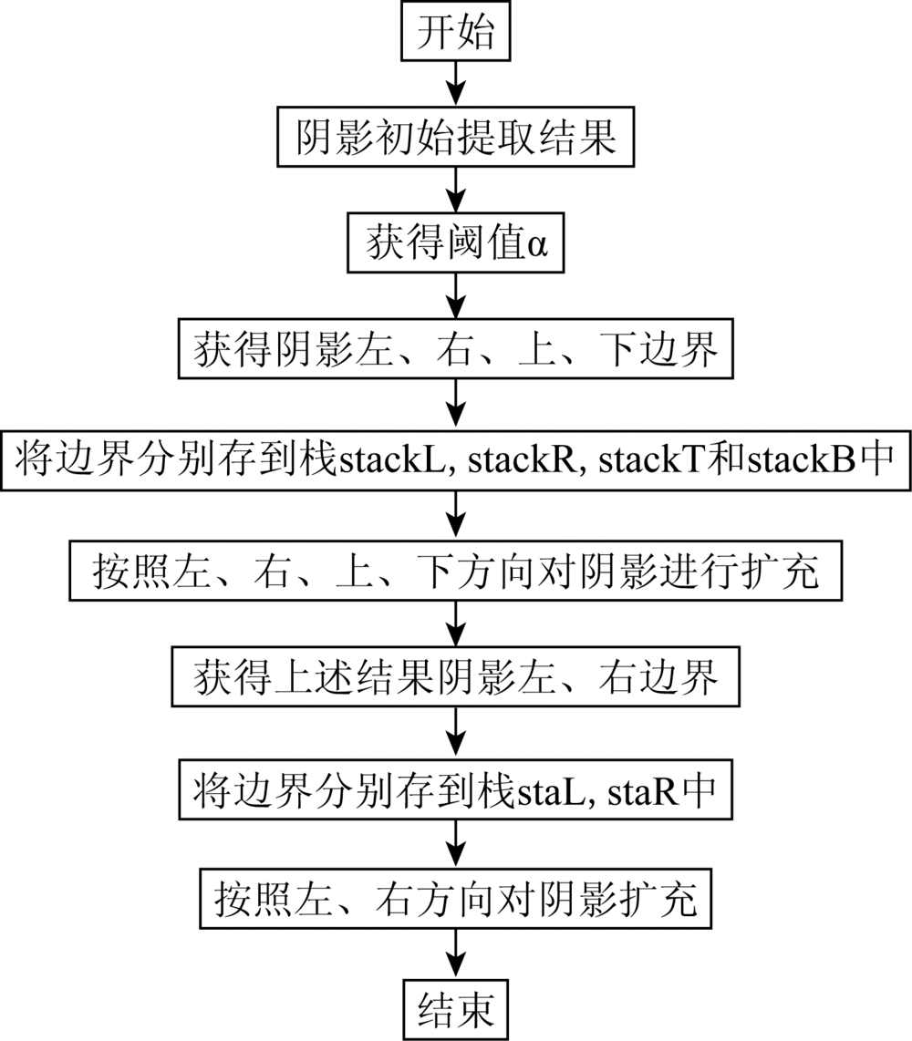
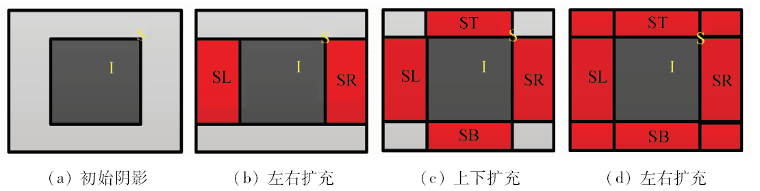
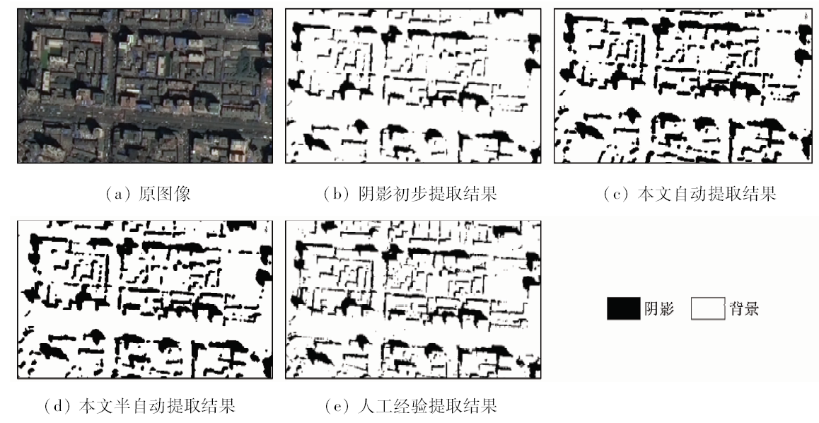
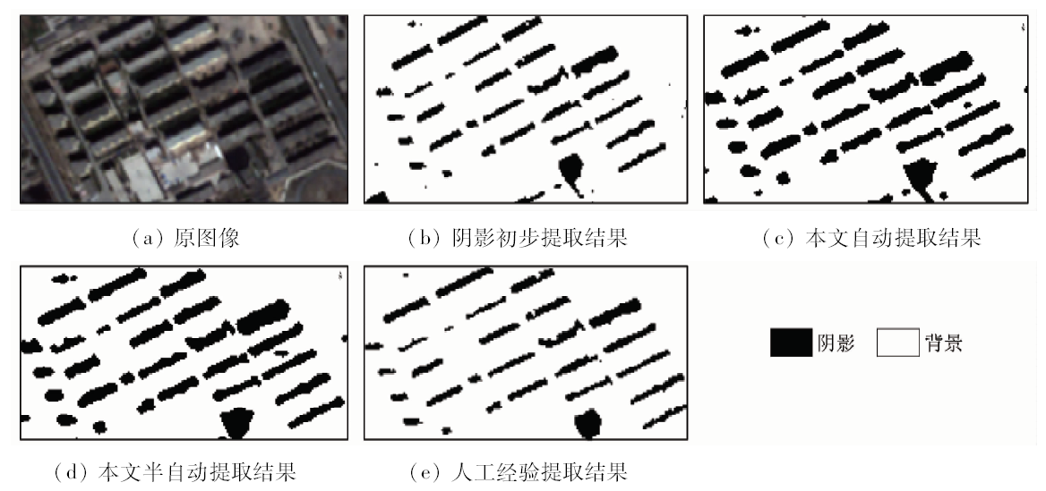
Abstract To tackle the incomplete extraction problem faced by most remote sensing images shadow extraction algorithms for extracting shadow,this paper purposes an automatic expansion extraction algorithm of remote sensing images shadow. Firstly, based on the characteristics that there is a peak of the rate of change of pixel values at the shadow boundary of the near infrared band and the rate of change of pixel values is stable inside the shadow, the authors established the criteria of shadow boundary judgment to determine whether the pixel is located in the shadow boundary. Second, on the basis of initial shadow extraction, each shadow is expanded by the criterion from the inside outward, which not only can take into account a single shadow area, but also is no longer confined to the global image features or local features of remote sensing images, so that shadow is extracted more completely. Experimental results show that the algorithm can effectively improve the accuracy and efficiency of shadow extraction.
|
| Keywords
remote sensing images
shadow boundary
extraction
rate of change
|
|
|
|
Corresponding Authors:
Shuwen YANG
E-mail: ysw040966@163.com
|
|
Issue Date: 15 March 2019
|
|
|
| [1] |
Finlayson G D, Hordley S D, Drew M S. Removing shadows from images using retinex [C]//Proceeding of the 10th Color Image Conference.Scottsclale:CIC, 2002: 823-836.
|
| [2] |
Irvir R B, Mckeown D M . Methods for exploiting the relationship between buildings and their shadows in aerial imagery[J]. IEEE Transaction on Systems:Man and Cybernetics, 1989,19(16):1564-1575.
doi: 10.1117/12.952691
url: http://ieeexplore.ieee.org/document/44071/
|
| [3] |
Mamassian P, Knill D C, Kersten D . The perception of cast shadows[J]. Trends in Cognitive Sciences, 1998,2(8):288-295.
doi: 10.1016/S1364-6613(98)01204-2
pmid: 21227211
url: http://linkinghub.elsevier.com/retrieve/pii/S1364661398012042
|
| [4] |
Etemadnia H, Alsha RIF M R.Automatic image shadow identification using LPF in homomorphic processing system [C]//Proceedings of VII Digital Image Computing: Techniques and Applications.Sydney:Committee of DICTA, 2003.
|
| [5] |
姚花琴, 杨树文, 刘正军 , 等. 基于QuickBird影像的城市高大地物阴影检测方法[J]. 国土资源遥感, 2015,27(2):51-55.doi: 10.6046/gtyyg.2015.02.08.
doi: 10.6046/gtzyyg.2015.02.08
url: http://d.wanfangdata.com.cn/Periodical/gtzyyg201502009
|
| [5] |
Yao H Q, Yang S W, Liu Z J , et al. A method of shadow detection for city tall ground objects based on QuickBird images[J]. Remote Sensing for Land and Resources, 2015,27(2):51-55.doi: 10.6046/gtyyg.2015.02.08.
|
| [6] |
张云飞, 张晔 . 利用二维熵自动确定图像分割的阈值[J].哈尔滨工程大学学报, 2006(3):353-356.
doi: 10.3969/j.issn.1006-7043.2006.03.008
url: http://www.cqvip.com/qk/95261x/200603/22185767.html
|
| [6] |
Zhang Y F, Zhang Y . Automatic threshold of image segmentation using 2-D entropy[J].Journal of Harbin Engineering University, 2006(3):353-356.
|
| [7] |
虢建宏, 田庆久, 吴昀昭 . 遥感影像阴影多波段检测与去除理论模型研究[J]. 遥感学报, 2006,10(2):151-159.
doi: 10.3321/j.issn:1007-4619.2006.02.002
url: http://www.cnki.com.cn/Article/CJFDTotal-YGXB200602001.htm
|
| [7] |
Guo J H, Tian Q J, Wu Y Z . Study on multispectral detecting shadow areas and a theoretical model of removing shadows from remote sensing images[J]. Journal of Remote Sensing, 2006,10(2):151-159.
|
| [8] |
于东方, 殷建平, 张国敏 . 一种基于灰度直方图的遥感影像阴影自动检测方法[J]. 计算机工程与科学, 2008,30(12):43-44,93.
doi: 10.3969/j.issn.1007-130X.2008.12.011
url: http://www.cnki.com.cn/Article/CJFDTotal-JSJK200812013.htm
|
| [8] |
Yu D F, Yin J P, Zhang G M . An automatic shadow detection method for remote sensing images based on gray histogram[J]. Computer Engineering and Science, 2008,30(12):43-44,93.
|
| [9] |
韩青松 . 基于Otsu算法的遥感图像阈值分割[D]. 新疆:新疆大学, 2011.
|
| [9] |
Han Q S . Remote Sensing Image Thresholding Segmentation Based on the Otsu Algorithm[D]. Xinjiong:Xinjiang University, 2011.
|
| [10] |
高贤君, 万幼川, 郑顺义 , 等. 航空遥感影像阴影的自动检测与补偿[J]. 武汉大学学报(信息科学版), 2012,37(11):1299-1302.
url: http://www.cnki.com.cn/Article/CJFDTotal-WHCH201211010.htm
|
| [10] |
Gao X J, Wan Y C, Zheng S Y , et al. Automatic shadow detection and compensation of aerial remote sensing images[J]. Geomatics and Information Science of Wuhan University, 2012,37(11):1299-1302.
|
| [11] |
李轶鲲, 杨树文, 刘涛 . 基于多峰直方图的遥感图像阈值自动选取算法[J]. 兰州交通大学学报, 2013,32(6):199-204.
doi: 10.3969/j.issn.1001-4373.2013.06.043
url: http://d.wanfangdata.com.cn/Periodical/lztdxyxb201306043
|
| [11] |
Li Y K, Yang S W, Liu T . An automatic threshold selection approach for remote sensing imagery of multimodal histograms[J]. Journal of Lanzhou Jiaotong University, 2013,32(6):199-204.
|
| [12] |
赵显富, 胡晓雯, 赵轩 . 一种基于彩色模型的遥感影像阴影检测方法[J].测绘通报, 2014(5):20-22,59.
doi: 10.13474/j.cnki.11-2246.2014.0149
url: http://d.wanfangdata.com.cn/Periodical/chtb201405006
|
| [12] |
Zhao X F, Hu X W, Zhao X . A method of remote sensing images shadow detection based on color models[J].Bulletin of Surveying and Mapping, 2014(5):20-22,59.
|
| [13] |
位明露, 詹总谦 . 一种改进的航空遥感影像阴影自动检测方法[J].测绘通报, 2016(6):14-17.
doi: 10.13474/j.cnki.11-2246.2016.0180
url: http://d.wanfangdata.com.cn/Periodical/chtb201606004
|
| [13] |
Wei M L, Zhan Z Q . An improved method of automatic shadow detection for aerial remote sensing images[J].Bulletin of Surveying and Mapping, 2016(6):14-17.
|
| [14] |
杨猛, 杨树文, 雍万铃 , 等. 集成特征分量的阴影多尺度分割方法[J]. 遥感信息, 2017,32(1):109-114.
doi: 10.3969/j.issn.1000-3177.2017.01.019
url: http://www.cqvip.com/QK/92871X/201701/671396283.html
|
| [14] |
Yang M, Yang S W, Yong W L , et al. Multi-scale shadow segmentation method based on characteristic component[J]. Remote Sensing Information, 2017,32(1):109-114.
|
| [15] |
池毓锋, 赖日文, 闫琦 , 等. 基于Landsat8 OLI数据的山区阴影信息检测与提取[J]. 山地学报, 2017,35(4):580-589.
doi: 10.16089/j.cnki.1008-2786.000256
url: http://www.cnki.com.cn/Article/CJFDTotal-SDYA201704018.htm
|
| [15] |
Chi Y F, Lai R W, Yan Q , et al. Detection and extraction of mountain shadow information from Landsat8 OLI data[J]. Mountain Research, 2017,35(4):580-589.
|
|
Viewed |
|
|
|
Full text
|
|
|
|
|
Abstract
|
|
|
|
|
Cited |
|
|
|
|
| |
Shared |
|
|
|
|
| |
Discussed |
|
|
|
|
 2019,
Vol. 31
2019,
Vol. 31