|
|
 |
|

|
|
|
High-resolution remote sensing image segmentation based on improved superpixel and marker watershed |
ZHANG Rui1( ), YOU Shucheng1(), DU Lei1, LU Jing1, HE Yun1, HU Yong2 ), YOU Shucheng1(), DU Lei1, LU Jing1, HE Yun1, HU Yong2 |
1. Land Satellite Remote Sensing Application Center, Ministry of Natural Resources, Beijing 100048, China
2. Chongqing Institute of Surveying and Monitoring for Planning and Natural Resources, Chongqing 400120, China |
|
|
|
|
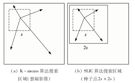
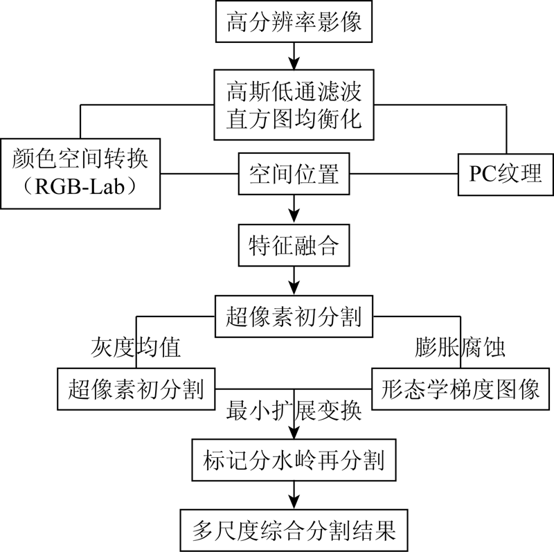
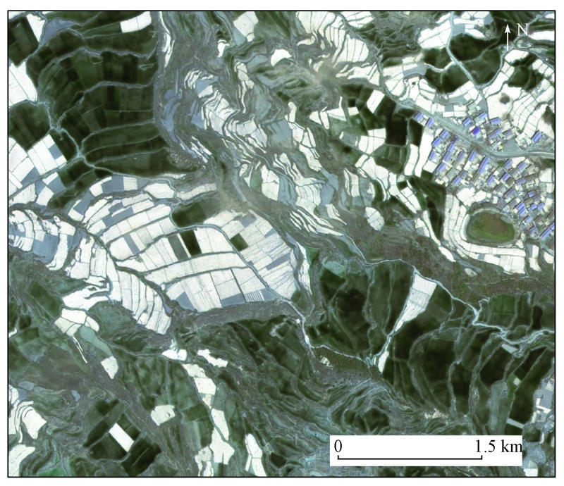
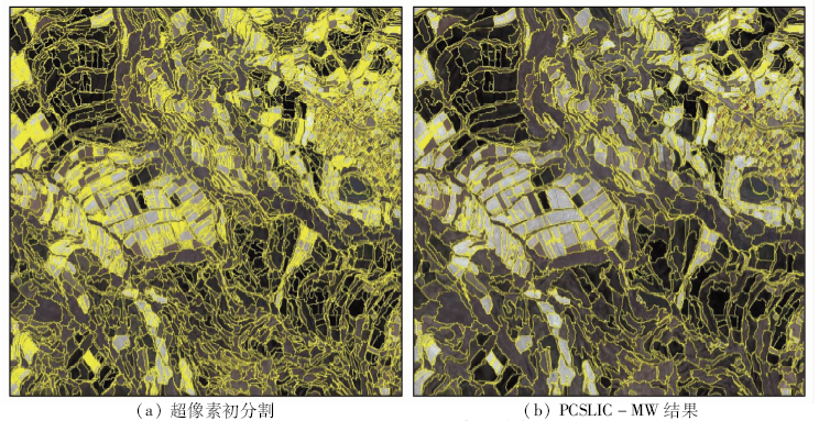
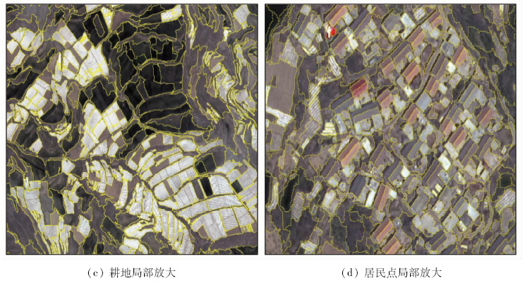
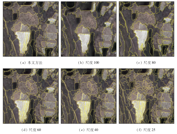
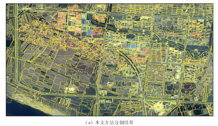
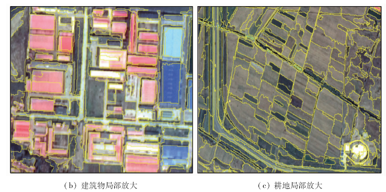
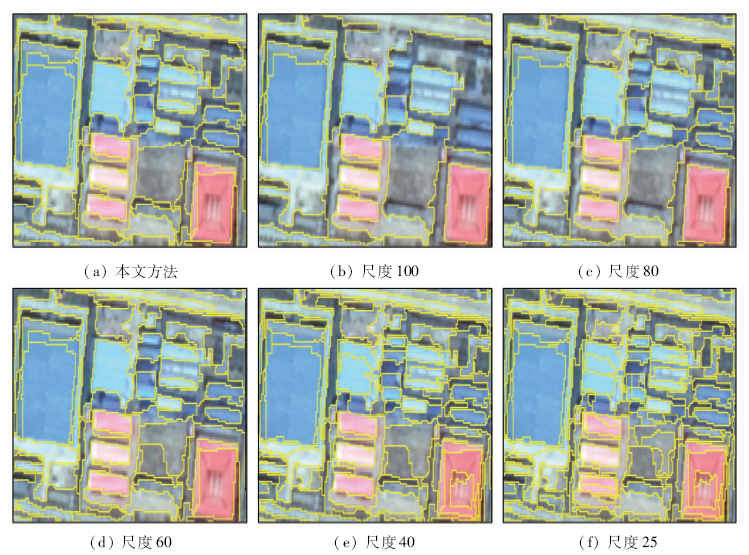
Abstract Image segmentation is a key step in object-oriented analysis of high resolution images and plays an important role in information extraction accuracy. In order to improve the segmentation performance of object-oriented algorithms for high-resolution remote sensing images, this paper proposes a segmentation method (PCSLIC-MW) to improve the superpixel and marker watershed, including feature fusion, superpixel initial segmentation, and control marker watershed segmentation. In the phase of superpixel segmentation, a new distance measure calculation rule is proposed, which combines color space, spatial position information and phase consistency texture feature. And then the gray value of each patch is calculated after superpixel segmentation, image reconstruction after segmentation, and morphological extension technology is used to extract local minimum (H-minima) so as to control the number of segmentation regions. The over-cutting produced by the traditional mathematical morphologic watershed segmentation algorithm is optimized and improved. The reconstructed image is conducted by Gaussian filter, and then the control marker watershed algorithm is used to re-segment the reconstructed image. For experiment, ZY3-02 satellite image and airborne aerial image are adopted to verify the proposed method, the precision and recall rate are used to evaluate the segmentation accuracy, and the results are compared with those of other segmentation methods to prove the segmentation effectiveness of the proposed method.
|
| Keywords
high-resolution image
watershed
superpixel
ZY3-02
|
|
|
|
Corresponding Authors:
YOU Shucheng
E-mail: ruizh581@163.com;youusc@126.com
|
|
Issue Date: 18 March 2021
|
|
|
| [1] |
刘扬, 付征叶, 郑逢斌. 高分辨率遥感影像目标分类与识别研究进展[J]. 地球信息科学学报, 2015,17(9):1080-1091.
|
| [1] |
Liu Y, Fu Z Y, Zheng F B. Review on high resolution remote sensing image classification and recognition[J]. Journal of Geo-Information Science, 2015,17(9):1080-1091.
|
| [2] |
姚丙秀, 黄亮, 许艳松. 一种结合超像素和图论的高空间分辨率遥感影像分割方法[J]. 国土资源遥感, 2019,31(3):72-79.doi: 10.6046/gtzyyg.2019.03.10.
|
| [2] |
Yao B X, Huang L, Xu Y S. A high resolution remote sensing image segmentation method based on superpixel and graph theory[J]. Remote Sensing for Land and Resources, 2019,31(3):72-79.doi: 10.6046/gtzyyg.2019.03.10.
|
| [3] |
明冬萍, 邱玉芳, 周文. 遥感模式分类中的空间统计学应用——以面向对象的遥感影像农田提取为例[J]. 测绘学报, 2016,45(7):825-833.
|
| [3] |
Ming D P, Qiu Y F, Zhou W. Applying spatial statistics into remote sensing pattern recognition:With case study of cropland extraction based on GeOBIA[J]. Acta Geodaetica et Cartographica Sinica, 2016,45(7):825-833.
|
| [4] |
陈春雷, 武刚. 面向对象的遥感影像最优分割尺度评价[J]. 遥感技术与应用, 2011,26(1):96-102.
|
| [4] |
Chen C L, Wu G. Evaluation of optimal segmentation scale with object-oriented method in remote sensing[J]. Remote Sensing Technology and Application, 2011,26(1):96-102.
|
| [5] |
郭琳, 裴志远, 吴全, 等. 面向对象的土地利用/覆盖遥感分类方法与流程应用[J]. 农业工程学报, 2010,26(7):194-198.
|
| [5] |
Guo L, Pei Z Y, Wu Q, et al. Application of method and process of object-oriented land use-cover classification using remote sensing images[J]. Transactions of the CSAE, 2010,26(7):194-198.
|
| [6] |
闫鹏飞, 明冬萍. 尺度自适应的高分辨率遥感影像分水岭分割方法[J]. 遥感技术与应用, 2018,32(2):321-330.
|
| [6] |
Yan P F, Ming D P. Segmentation of high spatial resolution remotely sensed data using watershed with self-adaptive parameterization[J]. Remote Sensing Technology and Application, 2018,32(2):321-330.
|
| [7] |
谢勰, 王辉, 张雪锋. 图像阈值分割技术中的部分和算法综述[J]. 西安邮电学院学报, 2011,16(3):1-5,13.
|
| [7] |
Xie X, Wang H, Zhang X F. A survey of partial sums algorithms in image thresholding techniques[J]. Journal of Xi’an University of Posts and Telecommunications, 2011,16(3):1-5,13.
|
| [8] |
朱俊杰, 杜小平, 范湘涛, 等. 图像多尺度边缘检测及图像多尺度分割研究[J]. 地理与地理信息科学, 2013,29(2):45-48,127.
|
| [8] |
Zhu J J, Du X P, Fan X T, et al. Multi-scale edge detection and multi-scale segmentation of imagery[J]. Geography and Geo-Information Science, 2013,29(2):45-48,127.
|
| [9] |
刘永学, 李满春, 毛亮. 基于边缘的多光谱遥感图像分割方法[J]. 遥感学报, 2006,10(3):350-356.
|
| [9] |
Liu Y X, Li M C, Mao L. An algorithm of multi-spectral remote sensing image segmentation based on edge information[J]. Journal of Remote Sensing, 2006,10(3):350-356.
|
| [10] |
宋熙煜, 周利莉, 李中国, 等. 图像分割中的超像素方法研究综述[J]. 中国图象图形学报, 2015,20(5):599-608.
|
| [10] |
Song X Y, Zhou L L, Li Z G, et al. Review on superpixel methods in image segmentation[J]. Journal of Image and Graphics, 2015,20(5):599-608.
|
| [11] |
陈敏, 朱庆, 朱军, 等. 多光谱遥感影像亮度空间相位一致性特征点检测[J]. 测绘学报, 2016,45(2):178-185.
|
| [11] |
Chen M, Zhu Q, Zhu J, et al. Interest point detection for multispectral remote sensing image using phase congruency in illumination space[J]. Acta Geodaetica et Cartographica Sinica, 2016,45(2):178-185.
|
| [12] |
韦春桃, 李彩露, 杨先武, 等. 基于相位一致性的遥感影像道路特征检测方法[J]. 地理与地理信息科学, 2011,27(4):62-66.
|
| [12] |
Wei C T, Li C L, Yang X W, et al. Road feature detection based on phase congruency using remote sensing image[J]. Geography and Geo-Information Science, 2011,27(4):62-66.
|
| [13] |
赵鹏飞, 周绍光, 裔阳, 等. 基于SLIC和主动学习的高光谱遥感图像分类方法[J]. 计算机工程与应用, 2017,53(3):183-187.
|
| [13] |
Zhao P F, Zhou S G, Yi Y, et al. Classification method of hyperspectral remote sensing image based on SLIC and active learning[J]. Computer Engineering and Applications, 2017,53(3):183-187.
|
| [14] |
Tarabalka Y, Chanussot J, Benediktsson J A. Segmentation and classification of hyperspectral images using watershed transformation[J]. Pattern Recognition, 2010,43(7):2367-2379.
|
| [15] |
Wang M, Yuan S G, Pan J, et al. Seamline determination for high resolution orthoimage mosaicking using watershed segmentation[J]. Photogrammetric Engineering and Remote Sensing, 2016,82(2):121-133.
|
| [16] |
Umesh Adiga P S, Chaudhuri B B. An efficient method based on watershed and rule-based merging for segmentation of 3-D histo-pathological images[J]. Pattern Recognition, 2001,34(7):1449-1458.
|
| [17] |
Soille P. Morphological image analysis principle and application[M]. Berlin,Germany:Springer Verlag, 1999: 123-140.
|
| [18] |
Achanta R, Shaji A, Simth K, et al. SLIC superpixels compared to state of the art superpixel methods[J]. IEEE Transactions on Software Engineering, 2012,34(11):2274-2282.
|
| [19] |
袁永华, 李玉, 赵雪梅. 基于谱聚类的高分辨率全色遥感影像分割[J]. 仪器仪表学报, 2016,37(7):1656-1664.
|
| [19] |
Yuan Y H, Li Y, Zhao X M. High-resolution panchromatic remote sensing image segmentation based on spectral clustering[J]. Chinese Journal of Scientific Instrument, 2016,37(7):1656-1664.
|
| [20] |
肖鹏峰, 冯学智, 赵书河, 等. 基于相位一致的高分辨率遥感图像分割方法[J]. 测绘学报, 2007,36(2):146-151.
|
| [20] |
Xiao P F, Feng X Z, Zhao S H, et al. Segmentation of high-resolution remotely sensed imagery based on phase congruency[J]. Acta Geodaetica et Cartographica Sinica, 2007,36(2):146-151.
|
| [21] |
贾春阳, 李卫华, 李小春. 基于自适应权值FNEA算法的高分辨率遥感图像分割[J]. 国土资源遥感, 2013,25(4):22-25.doi: 10.6046/gtzyyg.2013.04.04.
|
| [21] |
Jia C Y, Li W H, Li X C. High resolution remote sensing image segmentation based on weight adaptive fractal net evolution approach[J]. Remote Sensing for Land and Resources, 2013,25(4):22-25.doi: 10.6046/gtzyyg.2013.04.04.
|
| [22] |
于博, 牛铮, 王力, 等. 一种基于中性集和均值漂移的彩色遥感图像非监督建筑物提取方法[J]. 光谱学与光谱分析, 2013,33(4):1071-1075.
pmid: 23841431
|
| [22] |
Yu B, Niu Z, Wang L, et al. An unsupervised method of extracting constructions from color remote sensed image based on mean shift and neutrosophic set[J]. Spectroscopy and Spectral Analysis, 2013,33(4):1071-1075.
pmid: 23841431
url: https://www.ncbi.nlm.nih.gov/pubmed/23841431
|
|
Viewed |
|
|
|
Full text
|
|
|
|
|
Abstract
|
|
|
|
|
Cited |
|
|
|
|
| |
Shared |
|
|
|
|
| |
Discussed |
|
|
|
|
 2021,
Vol. 33
2021,
Vol. 33