|
|
 |
|

|
|
|
Hyperspectral image classification based on multiscale superpixels |
WANG Hua1,2( ), LI Weiwei2(), LI Zhigang2, CHEN Xueye1, SUN Le3 ), LI Weiwei2(), LI Zhigang2, CHEN Xueye1, SUN Le3 |
1. Key Laboratory of Urban Land Resources Monitoring and Simulation, Ministry of Natural Resources, Shenzhen 518034, China
2. Henan Key Laboratory of Food Safety Data Intelligence, Zhengzhou University of Light Industry, Zhengzhou 450002, China
3. Nanjing University of Information Science and Technology, School of Computer and Software, Nanjing 210044, China |
|
|
|
|
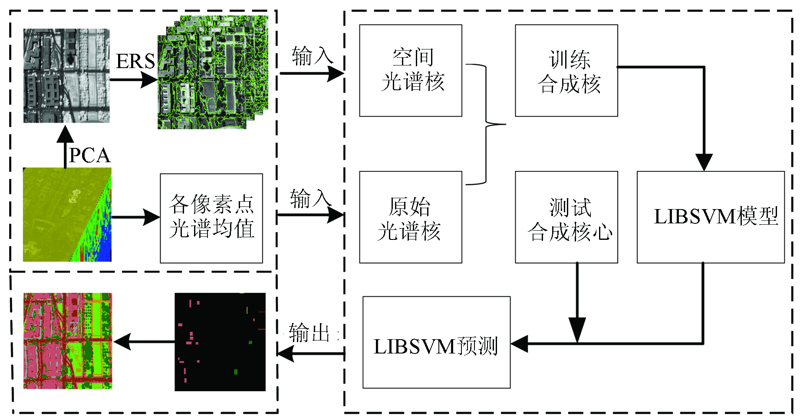
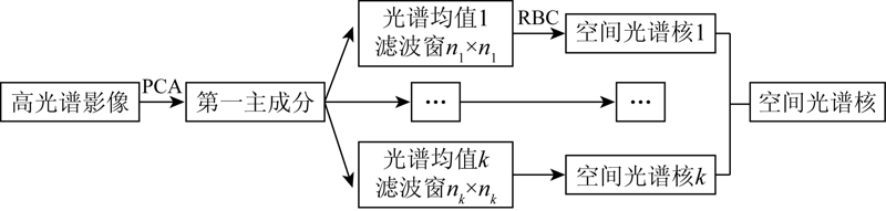
Abstract With the rapid development of remote sensing technology, the research on the classification methods of hyperspectral remote sensing images has received widespread attention. However, existing studies on the classification of hyperspectral remote sensing images conduct image segmentation using a single-scale superpixel method. As a result, the optimal superpixel number cannot be determined, image details are liable to be omitted, and a single kernel matrix cannot characterize multiple feature information, thus leading to a decrease in the classification precision. Therefore, this study proposes to perform multiscale superpixel segmentation of the first principal component of hyperspectral images. Then it conducts hyperspectral image classification using the composite kernel obtained by coupling the multiscale spatial-spectral kernel with the original spatial-spectral kernel according to weights. Finally, it tests and analyzes the proposed method using the hyperspectral images of the National Mall in Washington, D.C. as experimental data. The test results show that the effective classification precision of this method is 6.93% higher than that of the compared methods. As proved by the results, this method can be used to effectively solve the problems such as the lack of self-adaption of image spectra and incomplete spectrum information acquired, thus significantly improving the classification accuracy of hyperspectral images.
|
| Keywords
RBF kernel function
multiscale
superpixel
composite kernel SVM
hyperspectral image
|
|
|
|
Corresponding Authors:
LI Weiwei
E-mail: whuwanghua@163.com;1195203650@qq.com
|
|
Issue Date: 24 September 2021
|
|
|
| [1] |
Goetz A F H. Three decades of hyperspectral remote sensing of the Earth:A personal view[J]. Remote Sensing of Environment, 2009, 113(s1):5-16.
|
| [2] |
Uwe K, Andreas B, Udo S. Fusion trees for fast and accurate classification of hyperspectral data with ensembles of γ -divergence-based RBF networks[J]. Neural Computing and Applications, 2015, 26(2):253-262.
doi: 10.1007/s00521-014-1634-9
url: http://link.springer.com/10.1007/s00521-014-1634-9
|
| [3] |
胥海威, 杨敏华, 韩瑞梅, 等. 用随机决策树群算法进行高光谱遥感影像分类[J]. 应用科学学报, 2011, 29(6):598-604.
|
| [3] |
Xu H W, Yang M H, Han R M, et al. Classification of hyperspectral remote sensing images using stochastic decision tree group algorithm[J]. Journal of Applied Sciences, 2011, 29(6):598-604.
|
| [4] |
Guo Y H, Yin X J, Zhao X C, et al. Hyperspectral image classification with SVM and guided filter[J]. Eurasip Journal on Wireless Communications and Networking, 2019(1):1-9.
|
| [5] |
廖建尚, 王立国. 面向空间自相关信息的高光谱图像分类方法[J]. 农业机械学报, 2018, 49(6):215-224.
|
| [5] |
Liao J S, Wang L G. Hyperspectral image classification method for spatial autocorrelation information[J]. Transactions of the Chinese Society for Agricultural Machinery, 2018, 49(6):215-224.
|
| [6] |
Kavita B, Vijaya M. Evaluation of deep learning CNN model for land use land cover classification and crop identification using hyperspectral remote sensing images[J]. Journal of the Indian Society of Remote Sensing, 2019, 47(11):1949-1958.
doi: 10.1007/s12524-019-01041-2
|
| [7] |
朱瑞飞, 马经宇, 李竺强, 等. 多层感知卷积神经网络的国产多光谱影像分类[J]. 光学学报, 2020, 40(15):1-21.
|
| [7] |
Zhu R F, Ma J Y, Li Z Q, et al. Classification of domestic multispectral images based on multilayer perceptual convolutional neural network[J]. Acta Optica Sinica, 2020, 40(15):1-21.
|
| [8] |
Bera, Shrivastava. Analysis of various optimizers on deep convolutional neural network model in the application of hyperspectral remote sensing image classification[J]. International Journal of Remote Sensing, 2020, 41(7):2664-2683.
doi: 10.1080/01431161.2019.1694725
url: https://www.tandfonline.com/doi/full/10.1080/01431161.2019.1694725
|
| [9] |
Mohamad J, Mauro D M, Pierre C. Hyperspectral image classification based on mathematical morphology and tensor decomposit-ion[J]. Mathematical Morphology-Theory and Applications, 2020, 4(1):1-30.
doi: 10.1515/mathm-2020-0001
url: https://www.degruyter.com/document/doi/10.1515/mathm-2020-0001/html
|
| [10] |
Paulina, Koziol, Magda, et al. Comparison of spectral and spatial denoising techniques in the context of High Definition FT-IR imaging hyperspectral data[J]. Scientific Reports, 2018, 8(11):1444-1463.
doi: 10.1038/s41598-018-19829-6
url: https://doi.org/10.1038/s41598-018-19829-6
|
| [11] |
杜培军, 夏俊士, 薛朝辉, 等. 高光谱遥感影像分类研究进展[J]. 遥感学报, 2020, 20(2):236-256.
|
| [11] |
Du P J, Xia J S, Xue Z H, et al. Review of hyperspectral remote sensing image classification[J]. Journal of Remote Sensing, 2020, 20(2):236-256.
|
| [12] |
Wang P Y, Zhu H Q, Chen N. Umms:Efficient superpixel segmentation driven by a mixture of spatially constrained uniform distribution[J]. Ieice Transactions on Information and Systems, 2020, 103(1):181-185.
|
| [13] |
Sanghyun P. Crab region extraction method from tidal flat images using superpixels[J]. Journal of Advanced Information Technology and Convergence, 2019, 9(2):29-39.
doi: 10.14801/JAITC.2019.9.2.29
url: http://www.dbpia.co.kr/Journal/ArticleDetail/NODE09286089
|
| [14] |
Vitaliy K, Grzegorz M. Persistence-based resolution-independent meshes of superpixels[J]. Pattern Recognition Letters, 2020, 131(3):300-306.
doi: 10.1016/j.patrec.2020.01.014
url: https://linkinghub.elsevier.com/retrieve/pii/S0167865520300131
|
| [15] |
Tang K W, Su Z X, Jiang W, et al. Superpixels for large dataset subspace clustering[J]. Neural Computing and Applications, 2019, 31(12):8727-8736.
doi: 10.1007/s00521-018-3914-2
url: https://doi.org/10.1007/s00521-018-3914-2
|
| [16] |
Song D M, Tan X, Wang B, et al. Integration of super-pixel segmentation and deep-learning methods for evaluating earthquake-damaged buildings using single-phase remote sensing imagery[J]. International Journal of Remote Sensing, 2020, 41(3):1040-1066.
doi: 10.1080/01431161.2019.1655175
url: https://www.tandfonline.com/doi/full/10.1080/01431161.2019.1655175
|
| [17] |
Amin B, Riaz M M, Ghafoor A. Automatic image matting of synthetic aperture radar target chips[J]. Radio Engineering, 2020, 29(1):228-234.
|
| [18] |
Yuan X H, Guo S J, Li C W, et al. Near infrared star centroid detection by area analysis of multi-scale super pixel saliency fusion map[J]. Tsinghua Science and Technology, 2019, 24(3):291-300.
doi: 10.1109/TST.5971803
url: https://ieeexplore.ieee.org/xpl/RecentIssue.jsp?punumber=5971803
|
| [19] |
陈允杰, 马辰阳, 孙乐, 等. 基于边缘修正的高光谱图像超像素空谱核分类方法[J]. 电子学报, 2019, 47(1):73-81.
|
| [19] |
Chen Y J, Ma C Y, Sun L. Edge-modified superpixel based spectral-spatial kernel method for hyperspectral image classification[J]. Acta Electronica Sinica, 2019, 47(1):73-81.
|
| [20] |
刘忠林, 吴一全, 邹宇. 多尺度红外超像素图像模型的小目标检测[J]. 中国图象图形学报, 2019, 24(12):2159-2173.
|
| [20] |
Liu Z L, Wu Y Q, Zou Y. Multiscale infrared superpixel-image model for small-target detection[J]. Journal of Image and Graphics, 2019, 24(12):2159-2173.
|
| [21] |
Kang X D, Duan P H, Li S T. Hyperspectral image visualization with edge-preserving filtering and principal component analysis[J]. Information Fusion, 2020, 57(5):130-143.
doi: 10.1016/j.inffus.2019.12.003
url: https://linkinghub.elsevier.com/retrieve/pii/S1566253518303051
|
| [22] |
Shi C, Pun C M. Multiscale superpixel-based hyperspectral image classification using recurrent neural networks with stacked autoencoders[J]. IEEE Transactions on Multimedia, 2020, 22(2):487-501.
doi: 10.1109/TMM.6046
url: https://ieeexplore.ieee.org/xpl/RecentIssue.jsp?punumber=6046
|
| [23] |
Sun L, Ma C, Chen Y, et al. Adjacent superpixel-based multiscale spatial-spectral kernel for hyperspectral classification[J]. IEEE Journal of Selected Topics in Applied Earth Observations and Remote Sensing 2019, 12(6):1909-1919.
|
| [24] |
刘纯, 洪亮, 陈杰, 等. 融合像素—多尺度区域特征的高分辨率遥感影像分类算法[J]. 遥感学报, 2015, 19(2):228-239.
|
| [24] |
Liu C, Hong L, Chen J, et al. Fusion of pixel-based and multi-scale region-based features for the classification of high-resolution remote sensing image[J]. Journal of Remote Sensing, 2015, 19(2):228-239.
|
| [25] |
Ramzan M, Abid A, Khan H, et al. A review on state-of-the-art violence detection techniques[J]. IEEE Access, 2019, 7(9):107560-107575.
doi: 10.1109/Access.6287639
url: https://ieeexplore.ieee.org/xpl/RecentIssue.jsp?punumber=6287639
|
| [26] |
Chang C C, Huang H T. Automatic tuning of the RBF kernel parameter for batch-mode active learning algorithms:A scalable framework[J]. IEEE Transactions on Cybernetics, 2019, 49(12):4460-4472.
doi: 10.1109/TCYB.6221036
url: https://ieeexplore.ieee.org/xpl/RecentIssue.jsp?punumber=6221036
|
| [27] |
尚坤, 李培军, 程涛. 基于合成核支持向量机的高光谱土地覆盖分类[J]. 北京大学学报:自然科学版, 2011, 47(1):109-114.
|
| [27] |
Shang K, Li P J, Cheng T. Land cover classification of hyperspectral data using composite kernel support vector machines[J]. Acta Scientiarum Naturalium Universitatis Pekinensis, 2011, 47(1):109-114.
|
| [28] |
He J, Xu J L. Ultra-short-term wind speed forecasting based on support vector machine with combined kernel function and similar data[J]. Eurasip Journal on Wireless Communications and Networking, 2019(1):1-7.
|
| [29] |
Akbari D, Moradizadeh M, Akbari M. Spectral-spatial classification of hyperspectral imagery using neural network algorithm and hierarchical segmentation[J]. The International Archives of the Photogrammetry,Remote Sensing and Spatial Information Sciences, 2019, XLII-2(W12):1-5.
doi: 10.5194/isprs-archives-XLII-2-1-2018
url: https://www.int-arch-photogramm-remote-sens-spatial-inf-sci.net/XLII-2/1/2018/
|
|
Viewed |
|
|
|
Full text
|
|
|
|
|
Abstract
|
|
|
|
|
Cited |
|
|
|
|
| |
Shared |
|
|
|
|
| |
Discussed |
|
|
|
|
 2021,
Vol. 33
2021,
Vol. 33