|
|
 |
|

|
|
|
An analysis of landscape pattern spatial grain size effects in Qinghai Lake watershed |
Jun ZHAI1, Peng HOU1, Zhiping ZHAO2, Rulin XIAO1( ), Changzhen YAN3, Xuemin NIE4 ), Changzhen YAN3, Xuemin NIE4 |
1. Satellite Environment Center, Ministry of Environmental Protection, Beijing 100094, China
2. Chinese Research Academy of Environmental Sciences, Beijing 100012, China
3. Cold and Arid Regions Environmental and Engineering Research Institute, Chinese Academy of Sciences, Lanzhou 730000, China
4. Ecological and Environmental Monitoring Center of Remote Sensing of Qinghai Province, Xining 810007, China |
|
|
|
|
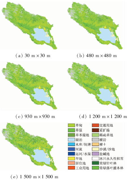
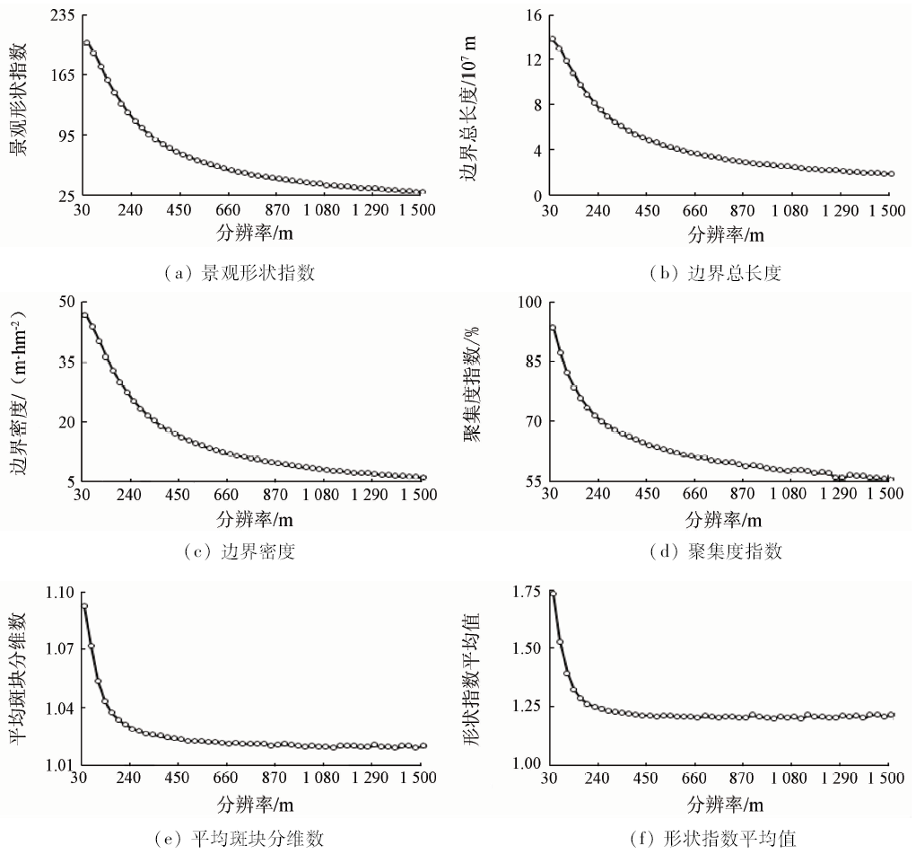
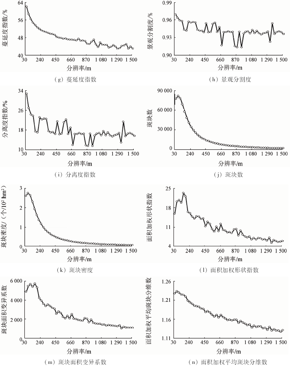
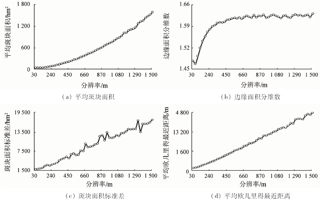
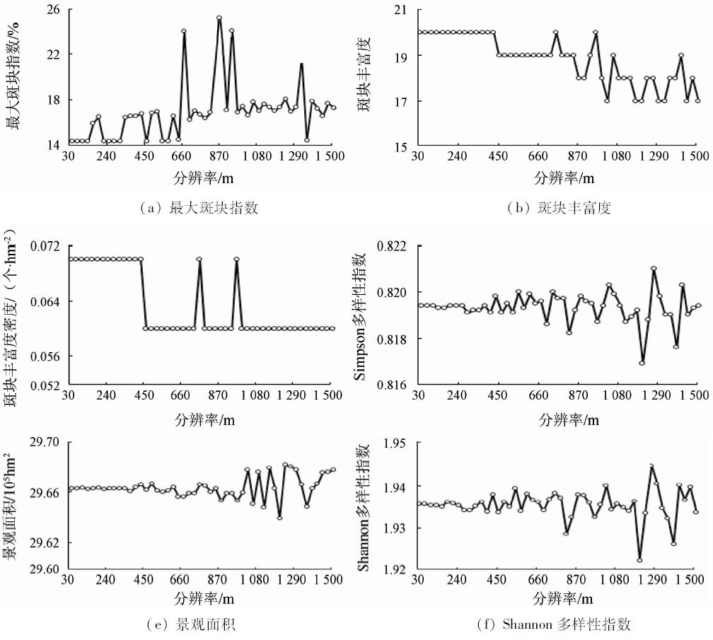
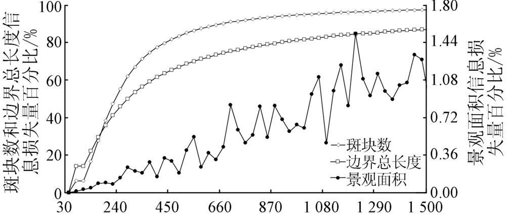
Abstract Watershed is the basic and important spatial scale unit of ecosystem. The scientific analysis of watershed scale landscape pattern depends heavily on the accuracy of the selection of the optimal grain size. In this paper, Qinghai Lake watershed was selected as the study area. Based on the object-oriented classification method, the authors interpreted satellite remote sensing data to generate watershed landscape data. Resampling method was used to obtain different spatial grain size watershed landscape data. Then the landscape pattern indexes were calculated and statistical relation curve was drawn between each landscape pattern index and grain size. Thus the scale effect of landscape pattern index could be identified. Finally, landscape pattern index information loss caused by increasing grain size was used to determine the optimum spatial grain size of watershed scale landscape pattern analysis. The result showed watershed landscape pattern index changed significantly with the increase of spatial grain size, but laws of change were different. Taking into account the landscape pattern spatial grain size effect and the change characteristics of information loss, the authors hold that the best spatial grain size choice of watershed landscape pattern analysis was 90 m.
|
| Keywords
watershed
scale
landscape pattern
optimal grain size
|
|
|
|
Corresponding Authors:
Rulin XIAO
E-mail: alexandershaw_84@163.com
|
|
Issue Date: 10 September 2018
|
|
|
| [1] |
侯鹏, 王桥, 王昌佐 , 等. 流域土地利用/土地覆被变化的生态效应[J] 地理研究, 2011,30(11):2092-2098.
|
| [1] |
Hou P, Wang Q, Wang C Z , et al. Ecological effect of land-use and land-cover change in a watershed scope[J] Geographical Research, 2012,30(11):2092-2098.
|
| [2] |
邬建国 . 景观生态学中的十大研究论题[J]. 生态学报, 2002,24(9):2074-2076.
doi: 10.3321/j.issn:1000-0933.2004.09.033
url: http://d.wanfangdata.com.cn/Periodical_stxb200409033.aspx
|
| [2] |
Wu J G . The key research topics in landscape ecology[J]. Acta Ecologica Sinica, 2002,24(9):2074-2076.
|
| [3] |
Gustafson E J . Quantifying landscape spatial pattern:What is the state of the art?[J]. Ecosystems, 1998,1(2):143-156.
doi: 10.1007/s100219900011
url: http://link.springer.com/10.1007/s100219900011
|
| [4] |
张娜 . 生态学中的尺度问题:内涵与分析方法[J]. 生态学报, 2006,26(7):2340-2355.
|
| [4] |
Zhang N . Scale issues in ecology:Concepts of scale and scale analysis[J]. Acta Ecologica Sinica, 2006,26(7):2340-2355.
|
| [5] |
邬建国 . 景观生态学——格局、过程、尺度与等级[M]. 2版.北京: 高等教育出版社, 2007: 95-152.
|
| [5] |
Wu J G .Landscape Ecology Pattern, Process,Scale and Hierarchy[M].2nd ed. Beijing: Higher Education Press, 2007: 95-152.
|
| [6] |
宗秀影, 刘高焕, 乔玉良 , 等. 黄河三角洲湿地景观格局动态变化分析[J]. 地球信息科学学报, 2009,11(1):91-97.
doi: 10.3969/j.issn.1560-8999.2009.01.014
url: http://d.wanfangdata.com.cn/Periodical/dqxxkx200901014
|
| [6] |
Zong X Y, Liu G H, Qiao Y L , et al. Study on dynamic changes of wetland landscape pattern in Yellow River delta[J]. Journal of Geo-Information Science, 2009,11(1):91-97.
|
| [7] |
张帅, 邵全琴, 刘纪远 , 等. 黄河源区玛多县土地利用/覆被及景观格局变化的遥感分析[J]. 地球信息科学, 2007,9(4):109-115,128.
|
| [7] |
Zhang S, Shao Q Q, Liu J Y , et al. Land use and landscape pattern change in Madoi County,the source region of Yellow River[J]. Geo-Information Science, 2007,9(4):109-115,128.
|
| [8] |
毕如田, 高艳 . 典型地貌景观指数的多尺度效应分析——以山西省运城市为例[J]. 地球信息科学学报, 2012,14(3):338-343.
doi: 10.3724/SP.J.1047.2012.00338
url: http://d.wanfangdata.com.cn/Periodical/dqxxkx201203009
|
| [8] |
Bi R T, Gao Y . Analysis of multi-scale effect of landscape indices of classical landforms in Yuncheng City,Shanxi Province[J]. Journal of Geo-Information Science, 2012,14(3):338-343.
|
| [9] |
郭冠华, 陈颖彪, 魏建兵 , 等. 粒度变化对城市热岛空间格局分析的影响[J]. 生态学报, 2012,32(12):3764-3772.
doi: 10.5846/stxb201107181068
url: http://doi.med.wanfangdata.com.cn/10.5846/stxb201107181068
|
| [9] |
Guo G H, Chen Y B, Wei J B , et al. Impacts of grid sizes on urban heat island pattern analysis[J]. Acta Ecologica Sinica, 2012,32(12):3764-3772.
|
| [10] |
孙晓宇, 苏奋振, 吕婷婷 , 等. 珠江口西岸土地利用景观格局变化及驱动力分析[J]. 地球信息科学学报, 2009,11(4):436-441.
doi: 10.3969/j.issn.1560-8999.2009.04.005
url: http://d.wanfangdata.com.cn/Periodical/dqxxkx200904005
|
| [10] |
Sun X Y, Su F Z, Lyu T T , et al. Analysis on landscape spatial pattern changes of land use and its driving forces in coastal zone of western Pearl River estuary[J]. Journal of Geo-Information Science, 2009,11(4):436-441.
|
| [11] |
王思远, 刘纪远, 张增祥 , 等. 近10年中国土地利用格局及其演变[J]. 地理学报, 2002,57(5):523-530.
doi: 10.3321/j.issn:0375-5444.2002.05.003
url: http://d.wanfangdata.com.cn/Periodical_dlxb200205003.aspx
|
| [11] |
Wang S Y, Liu J Y, Zhang Z X , et al. Spatial pattern change of land use in China in recent 10 years[J]. Acta Geographica Sinica, 2002,57(5):523-530.
|
| [12] |
申卫军, 邬建国, 林永标 , 等. 空间粒度变化对景观格局分析的影响[J]. 生态学报, 2003,23(12):2506-2519.
doi: 10.3321/j.issn:1000-0933.2003.11.003
url: http://d.wanfangdata.com.cn/Periodical/stxb200312002
|
| [12] |
Shen W J, Wu J G, Lin Y B , et al. Effects of changing grain size on landscape pattern analysis[J]. Acta Ecologica Sinica, 2003,23(12):2506-2519.
|
| [13] |
Turner M G, O’Neill R V,Gardner R H ,et al.Effects of changing spatial scale on the analysis of landscape pattern[J]. Landscape Ecology, 1989,3(3/4):153-162.
doi: 10.1007/BF00131534
url: http://link.springer.com/10.1007/BF00131534
|
| [14] |
Wu J G, Shen W J, Sun W Z , et al. Empirical patterns of the effects of changing scale on landscape metrics[J]. Landscape Ecology, 2002,17(8):761-782.
doi: 10.1023/A:1022995922992
url: http://link.springer.com/10.1023/A:1022995922992
|
| [15] |
Wu J G . Effects of changing scale on landscape pattern analysis:Scaling relations[J]. Landscape Ecology, 2004,19(2):125-138.
doi: 10.1023/B:LAND.0000021711.40074.ae
url: http://link.springer.com/10.1023/B:LAND.0000021711.40074.ae
|
| [16] |
于磊, 赵彦伟, 张远 , 等. 基于最佳分析粒度的大辽河流域湿地景观格局分析[J]. 环境科学学报, 2011,31(4):873-879.
url: http://d.wanfangdata.com.cn/Periodical_hjkxxb201104029.aspx
|
| [16] |
Yu L, Zhao Y W, Zhang Y , et al. Landscape pattern analysis of wetlands in the Daliaohe Watershed,based on optimal grain size[J]. Acta Scientiae Circumstantiae, 2011,31(4):873-879.
|
| [17] |
郭琳, 宋戈, 张远景 , 等. 基于最佳分析粒度的巴彦县土地利用景观空间格局分析[J]. 资源科学, 2013,35(10):2052-2060.
url: http://d.wanfangdata.com.cn/Periodical_zykx201310016.aspx
|
| [17] |
Guo L, Song G, Zhang Y J , et al. Land-use spatial analysis for Bayan County based on optimal grain size[J]. Resources Science, 2013,35(10):2052-2060.
|
| [18] |
王艳芳, 沈永明, 陈寿军 , 等. 景观格局指数相关性的幅度效应[J], 生态学杂志, 2012,31(8):2091-2097.
|
| [18] |
Wang Y F, Shen Y M, Chen S J , et al. Range effect of the correlations among landscape metrics[J], Chinese Journal of Ecology, 2012,31(8):2091-2097.
|
| [19] |
游丽平, 林广发, 杨陈照 , 等. 景观指数的空间尺度效应分析——以厦门岛土地利用格局为例[J]. 地球信息科学, 2008,10(1):74-79.
|
| [19] |
You L P, Lin G F, Yang C Z , et al. The effects of spatial scales on landscape indices——A case study of the landuse pattern of Xiamen Island[J]. Geo-Information Science, 2008,10(1):74-79.
|
| [20] |
陈利顶, 傅伯杰, 徐建英 , 等. 基于"源-汇"生态过程的景观格局识别方法——景观空间负荷对比指数[J]. 生态学报, 2003,23(11):2406-2413.
doi: 10.3321/j.issn:1000-0933.2003.11.025
url: http://d.wanfangdata.com.cn/Periodical/stxb200311025
|
| [20] |
Chen L D, Fu B J, Xu J Y , et al. Location-weighted landscape contrast index:A scale independent approach for landscape pattern evaluation based on "Source-Sink" ecological processes[J]. Acta Ecologica Sinic, 2003,23(11):2406-2413.
|
| [21] |
崔步礼, 常学礼, 左登华 , 等. 沙地景观中矢量数据栅格化方法及尺度效应[J]. 生态学报, 2009,29(5):2463-2472.
url: 年度引用
|
| [21] |
Cui B L, Chang X L, Zuo D H , et al. Rasterizing vector data and its scaling effect for a sand landscape[J]. Acta Ecologica Sinic, 2009,29(5):2463-2472.
|
| [22] |
吕志强, 吴志峰, 张景华 . 基于最佳分析尺度的广州市景观格局分析[J]. 地理与地理信息科学, 2007,23(4):89-92.
|
| [22] |
Lyu Z Q, Wu Z F, Zhang J H . Landscape pattern analysis of Guangzhou based on optimization-scale[J]. Geography and Geo-Information Science, 2007,23(4):89-92.
|
| [23] |
郑建蕊, 蒋卫国, 周廷刚 , 等. 洞庭湖区湿地景观指数选取与格局分析[J]. 长江流域资源与环境, 2010,19(3):305-310.
|
| [23] |
Zheng J R, Jiang W G, Zhou T G , et al. Selection of wetland landscape indices and analysis of landscape pattern in Dongting Lake area[J]. Resources and Environment in the Yangtze Basin, 2010,19(3):305-310.
|
| [24] |
邢宇 . 青藏高原32年湿地对气候变化的空间响应[J]. 国土资源遥感, 2015,27(3):99-107.doi: 10.6046/gtzyyg.2015.03.17.
doi: 10.6046/gtzyyg.2015.03.17
|
| [24] |
Xing Y . Spatial responses of wetland change to climate in 32 years in Qinghai-Tibet Plateau[J]. Remote Sensing for Land and Resources, 2015,27(3):99-107.doi: 10.6046/gtzyyg.2015.03.17.
|
| [25] |
江波, 张路, 欧阳志云 . 青海湖湿地生态系统服务价值评估[J]. 应用生态学报, 2015,26(10):3137-3144.
url: http://d.wanfangdata.com.cn/Periodical/yystxb201510027
|
| [25] |
Jiang B, Zhang L, Ouyang Z Y . Ecosystem services valuation of Qinghai Lake[J]. Chinese Journal of Applied Ecology, 2015,26(10):3137-3144.
|
| [26] |
姜翠红, 李广泳, 程滔 , 等. 青海湖流域生态服务价值时空格局变化及其影响因子研究[J]. 资源科学, 2016,38(8):1572-1584.
doi: 10.18402/resci.2016.08.15
url: http://d.wanfangdata.com.cn/Periodical/zykx201608015
|
| [26] |
Jiang C H, Li G Y, Cheng T , et al. Spatial-temporal pattern variation and impact factors of ecosystem service values in the Qinghai Lake Watershed[J]. Resources Science, 2016,38(8):1572-1584.
|
| [27] |
杨娅楠, 王金亮, 陈光杰 , 等. 抚仙湖流域土地利用格局与水质变化关系[J]. 国土资源遥感, 2016,28(1):159-165.doi: 10.6046/gtzyyg.2016.01.23.
doi: 10.6046/gtzyyg.2016.01.23
url: http://d.wanfangdata.com.cn/Periodical/gtzyyg201601023
|
| [27] |
Yang Y N, Wang J L, Chen G J , et al. Relationship between land use pattern and water quality change in Fuxian Lake basin[J]. Remote Sensing for Land and Resources, 2016,28(1):159-165.doi: 10.6046/gtzyyg.2016.01.23.
|
|
Viewed |
|
|
|
Full text
|
|
|
|
|
Abstract
|
|
|
|
|
Cited |
|
|
|
|
| |
Shared |
|
|
|
|
| |
Discussed |
|
|
|
|
 2018,
Vol. 30
2018,
Vol. 30