|
|
 |
|

|
|
|
Study of crown information extraction of Picea schrenkiana var. tianschanicabased on high-resolution satellite remote sensing data |
| Yufeng LIU1,2, Ying PAN3, Hu LI1,2 |
1. College of Computer and Information Engineering, Chuzhou University, Chuzhou 239000, China
2. R&D Center of Data Products and Application Software on Anhui High Resolution Earth Observation System, Chuzhou 239000, China
3. Students Affairs Department, Chuzhou University, Chuzhou 239000, China |
|
|
|
|
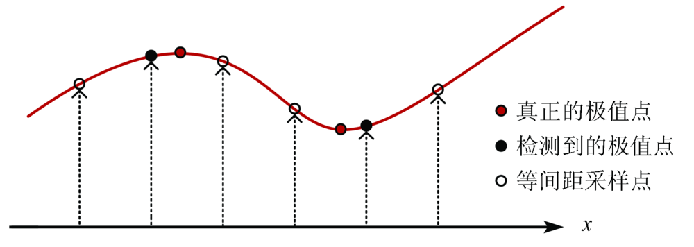
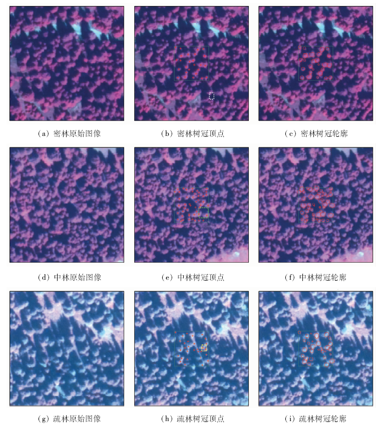
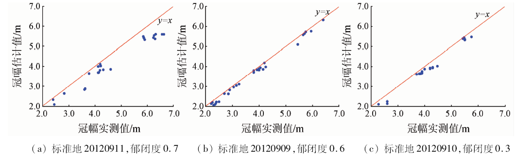
Abstract For the reasons that images of Picea schrenkiana var. tianschanica in the western tianshan forest were round or suborbicular, crown information extraction was conducted with the space geometric features. According to the workflow of “investigating the features of Picea schrenkiana var. tianschanica in satellite images - extracting tree crown information-estimating tree crown width with remote sensing images”, a method for estimating tree crown width in Central Asia mountain forests based on remote sensing images was proposed and evaluated, with the purpose of challenging the problems that it is difficult to set the marks for marking watershed transform target ground objects and the active contour model evolution results are limited by the original positions of contour lines. Multi-scale blob detection, marking watershed transform and GVF Snake active contour model were orderly combined for tree crown information extraction. This technical process integrated and optimized the process of tree crown information extraction, and gained the tree crown contour distribution map of Picea schrenkiana var. tianschanica from images. A comparison with the measured tree crown width of each tree in the investigated sample ground shows that this method well estimates the tree crown width of Picea schrenkiana var. Tianschanica with high, medium or low canopy density, with the mean error being 10.8%, 4.5% and 6.4%, respectively. The research results provide a better solution for the key technical problem of tree crown interpretation for high-resolution remote sensing data in forest resource monitoring.
|
| Keywords
high resolution remote sensing
Picea schrenkiana var. tianschanica’s crown
multi-scale blob detection
marking watershed transform
GVF Snake model
|
|
|
|
Issue Date: 03 December 2019
|
|
|
| [1] |
Song C, Band L E . MVP:A model to simulate the spatial patterns of photosynthetically ac[J]. Revue Canadienne De Recherche Forestière, 2004,34(34):1192-1203.
|
| [2] |
Pouliot D A, King D J, Bell F W , et al. Automated tree crown detection and delineation in high-resolution digital camera imagery of coniferous forest regeneration[J]. Remote Sensing of Environment, 2002,82(2-3):322-334.
|
| [3] |
Hay G J, Blaschke T, Marceau D J . A comparison of three image-object methods for the multiscale analysis of landscape structure[J]. ISPRS Journal of Photogrammetry and Remote Sensing, 2003,57(5-6):327-345.
|
| [4] |
Johansen K, Coops N C, Gergel S E , et al. Application of high spatial resolution satellite imagery for riparian and forest ecosystem classification[J]. Remote Sensing of Environment, 2007,110(1):29-44.
|
| [5] |
Leckie D G, Gougeon F A, Tinis S , et al. Automated tree recognition in old growth conifer stands with high resolution digital imagery[J]. Remote Sensing of Environment, 2005,94(3):311-326.
|
| [6] |
Erikson M, Olofsson K . Comparison of Three Individual Tree Crown Detection Methods[M]. New York:Springer-Verlag, 2005.
|
| [7] |
Kalapala M, Rao V S, Srinivas K. Robust tree crown delineation using novel marker controlled watershed segmentation algorithm [C]//International Journal of Engineering Research and Technology.ESRSA Publications, 2012.
|
| [8] |
熊轶群, 吴健平 . 基于高分辨率遥感图像的树冠面积提取方法[J]. 地理与地理信息科学, 2007,23(6):30-33.
|
| [8] |
Xiong Y Q, Wu J P . Tree-crown area detection algorithm for high spatial resolution remote-sensing image[J]. Geography and Geo-Information Science, 2007,23(6):30-33.
|
| [9] |
李德仁, 童庆禧, 李荣兴 , 等. 高分辨率对地观测的若干前沿科学问题[J]. 中国科学(地球科学), 2012,42(6):805-813.
|
| [9] |
Li D R, Tong Q X, Li R X , et al. Current issues in high-resolution earth observation technology[J]. Science China(Earth Science), 2012,42(6):805-813.
|
| [10] |
Zhao J, Huang L, Yang H, et al. Fusion and assessment of high-resolution WorldView-3 satellite imagery using NNDiffuse and Brovey algotirhms [C]//Geoscience and Remote Sensing Symposium.IEEE, 2016: 2606-2609.
|
| [11] |
Moon W K, Shen Y W, Min S B , et al. Computer-aided tumor detection based on multi-scale blob detection algorithm in automated breast ultrasound images[J]. IEEE Transactions on Medical Imaging, 2013,32(7):1191-1200.
|
| [12] |
Quine B M, Tarasyuk V, Mebrahtu H , et al. Determining star-image location:A new sub-pixel interpolation technique to process image centroids[J]. Computer Physics Communications, 2007,177(9):700-706.
|
| [13] |
陈杰, 邓敏, 肖鹏峰 , 等. 结合支持向量机与粒度计算的高分辨率遥感影像面向对象分类[J]. 测绘学报, 2011,40(2):135-141.
|
| [13] |
Chen J, Deng M, Xiao P F , et al. Object-oriented classification of high resolution imagery combining support vector machine with granular computing[J]. Acta Geodaetica et Cartographica Sinica, 2011,40(2):135-141.
|
| [14] |
Vincent L, Soille P . Watersheds in digital spaces:An efficient algorithm based on immersion simulations[J]. Transactions on Pattern Analysis and Machine Intelligence, 1991,13(6):583-598.
|
| [15] |
Song X, Tang G, Li F , et al. Extraction of loess shoulder-line based on the parallel GVF Snake model in the loess hilly area of China[J]. Computers and Geosciences, 2013,52(1):11-20.
|
|
Viewed |
|
|
|
Full text
|
|
|
|
|
Abstract
|
|
|
|
|
Cited |
|
|
|
|
| |
Shared |
|
|
|
|
| |
Discussed |
|
|
|
|
 2019,
Vol. 31
2019,
Vol. 31