|
|
 |
|

|
|
|
SBAS-InSAR-based monitoring and inversion of surface subsidence of the Shadunzi Coal Mine in Hami City, Xinjiang |
SHA Yonglian1,2( ), WANG Xiaowen1,3(), LIU Guoxiang1,3, ZHANG Rui1,3, ZHANG Bo1 ), WANG Xiaowen1,3(), LIU Guoxiang1,3, ZHANG Rui1,3, ZHANG Bo1 |
1. Faculty of Geosciences and Environmental Engineering, Southwest Jiaotong University, Chengdu 611756, China
2. Beijing Institute of Technology Chongqing Innovation Center, Chongqing 401120, China
3. State-province Joint Engineering Laboratory of Spatial Information Technology of High-speed Railway Safety, Chengdu 611756, China |
|
|
|
|
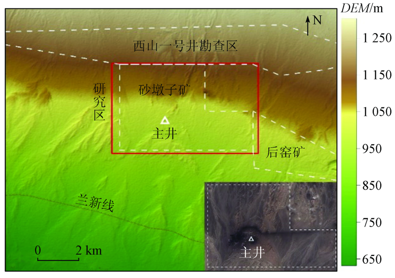
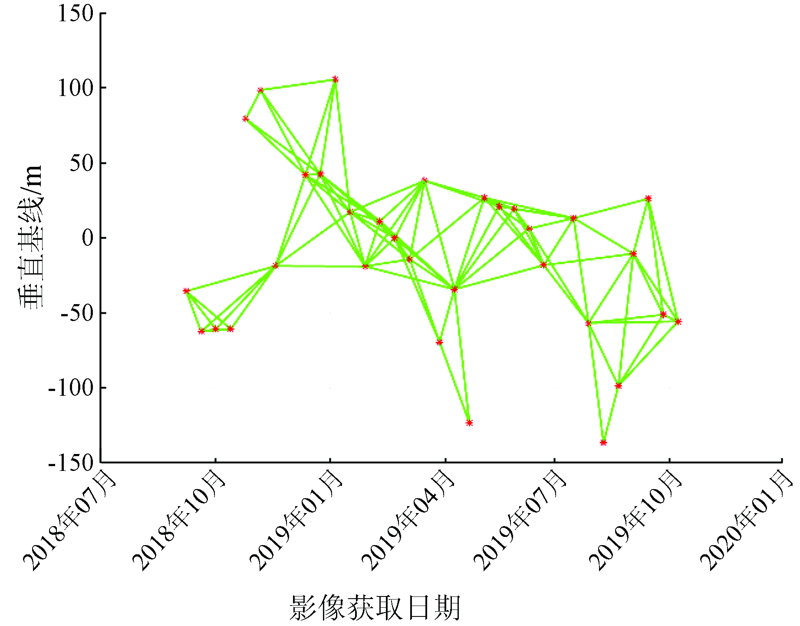
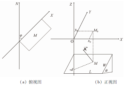
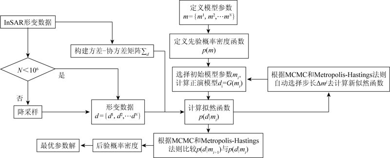
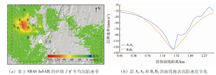
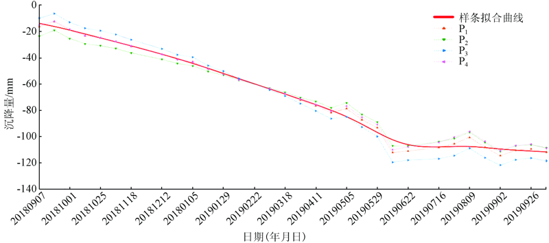
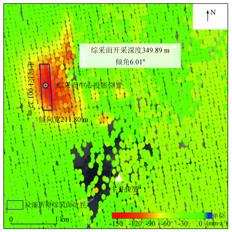
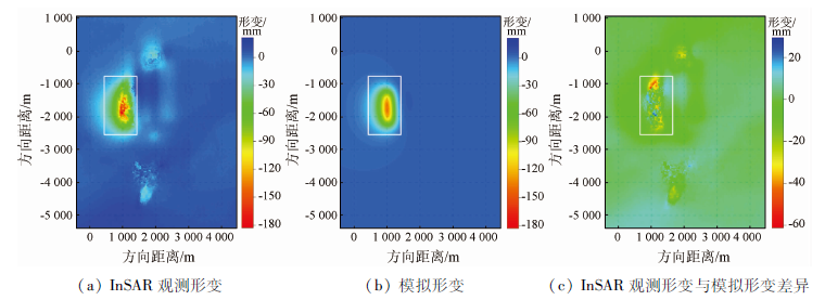
Abstract The monitoring of surface subsidence in mining areas can provide key information for local production safety protection and mining planning and management. Based on the Sentinel-1A images from September 2018 to October 2019, this study characterized the surface subsidence in the mining area of the Shadunzi Coal Mine in Hami City, Xinjiang, China using the combined small baseline subset (SBAS) and interferometric synthetic aperture radar (InSAR) analysis. The InSAR measurement results revealed a subsidence funnel with a maximum subsidence rate of about -150 mm/a to the northwest of the main shaft of the coal mine. As indicated by the displacement time series, the subsidence funnel showed a significant linear subsidence pattern from September 2018 to June 2019 and gradually stabilized thereafter. Then the surface deformation inversion was conducted using the Okada rectangular dislocation model to obtain the parameters of the working face of the coal mine. The modeling results showed that the working face had a depth of about 349.89 m, a length of about 1 001.27 m, and a width of about 211.80 m. Based on the inversion results as well as the apparent density of the coal seams, the annual mining capacity of the coal mine was estimated to be about 3.18 Mt during 2018—2019, which is consistent with the reported annual production capacity of the coal mine. This paper provides a feasible way to conduct the parameter inversion of coal mine working face under the constraints of InSAR measurements and to infer the relationship between the working face parameters and the mining capacity according to the apparent density of coal seams.
|
| Keywords
mining-induced surface subsidence
Shadunzi Coal Mine
SBAS-InSAR
parameter inversion
|
|
|
|
Corresponding Authors:
WANG Xiaowen
E-mail: syl973281310@163.com;insarwxw@swjtu.edu.cn
|
|
Issue Date: 24 September 2021
|
|
|
| [1] |
张方哲. 中国煤矿资源评估与开发可行性研究[D]. 北京:中国地质大学(北京),2010.
|
| [1] |
Zhang F Z. Coal resource assesment and development feasibility study of China[D]. Beijing:China University of Geosciences(Beijing),2010.
|
| [2] |
何国清, 杨伦, 凌赓娣, 等. 矿山开采沉陷学[M]. 徐州: 中国矿业大学出版社, 1991.
|
| [2] |
He G Q, Yang L, Ling G D, et al. Mining subsidence theory[M]. Xuzhou: China University of Mining & Technology Publisher,
|
| [3] |
朱建军, 李志伟, 胡俊. InSAR变形监测方法与研究进展[J]. 测绘学报, 2017, 46(10):1717-1733.
|
| [3] |
Zhu J J, Li Z W, Hu J. Research progress and methods of InSAR for deformation monitoring[J]. Acta Geodaetica et Cartographica Sinica, 2017, 46(10):1717-1733.
|
| [4] |
王志勇, 张继贤, 黄国满. 基于InSAR的济宁矿区沉降精细化监测与分析[J]. 中国矿业大学学报, 2014, 43(1):169-174.
|
| [4] |
Wang Z Y, Zhang J X, Huang G M. Precise monitoring and analysis of the land subsidence in Jining coal mining area based on InSAR technique[J]. Journal of China University of Mining & Technology, 2014, 43(1):169-174.
|
| [5] |
马飞虎, 姜珊珊, 孙翠羽. PSInSAR在铅山县矿区地表沉降监测中的应用[J]. 应用科学学报, 2018, 36(6):95-103.
|
| [5] |
Ma F H, Jiang S S, Sun C Y. Application of PSInSAR in monitoring land subsidence in Yanshan mining area[J]. Journal of Applied Sciences-Eletronics and Information Engineering, 2018, 36(6):95-103.
|
| [6] |
李德仁. InSAR技术进步与地面沉降监测应用[J]. 上海国土资源, 2013, 34(4):1-6.
|
| [6] |
Li D R. InSAR Technological progress and its application to land subsidence monitoring[J]. Shanghai Land & Resources, 2013, 34(4):1-6.
|
| [7] |
Zebker H A, Rosen P A, Hensley S. Atmospheric effects in interferometric synthetic aperture radar surface deformation and topographic maps[J]. Journal of Geophysical Research, 1997, 102(B4):7547-7563.
doi: 10.1029/96JB03804
url: http://doi.wiley.com/10.1029/96JB03804
|
| [8] |
Ferretti A, Prati C, Rocca F. Non-linear subsidence rate estimation using permanent scatterers in differential SAR interferometry[J]. IEEE Transactions on Geoscience and Remote Sensing, 2000, 38(5):2202-2212.
doi: 10.1109/36.868878
url: http://ieeexplore.ieee.org/document/868878/
|
| [9] |
葛大庆, 王艳, 范景辉, 等. 地表形变D-InSAR监测方法及关键问题分析[J]. 国土资源遥感, 2007, 19(4):14-22.doi: 10.6046/gtzyyg.2007.04.03.
doi: 10.6046/gtzyyg.2007.04.03
|
| [9] |
Ge D Q, Wang Y, Fan J H, et al. A study of surface deformation monitoring using differential SAR interferometry technique and an analysis of its key problems[J]. Remote Sensing for Land and Resources, 2007, 19(4):14-22.doi: 10.6046/gtzyyg.2007.04.03.
doi: 10.6046/gtzyyg.2007.04.03
|
| [10] |
Casu F, Manzo M, Lanari R. A quantitative assessment of the SBAS algorithm performance for surface deformation retrieval from DInSAR data[J]. Remote Sensing of Environment, 2006, 102(3-4):195-210.
doi: 10.1016/j.rse.2006.01.023
url: https://linkinghub.elsevier.com/retrieve/pii/S0034425706000526
|
| [11] |
Williams S, Bock Y, Fang P. Integrated satellite interferometry:Tropospheric noise,GPS estimates and implications for interferometric synthetic aperture radar products[J]. Journal of Geophysical Research:Solid Earth, 1998, 103(B11).
|
| [12] |
尹宏杰, 朱建军, 李志伟. 基于SBAS的矿区形变监测研究[J]. 测绘学报, 2011, 40(1):52-58.
|
| [12] |
Yin H J, Zhu J J, Li Z W. Ground subsidence monitoring in mining area using DInSAR SBAS algorithm[J]. Acta Geodaetica et Cartographica Sinica, 2011, 40(1):52-58.
|
| [13] |
赵伟颖, 邓喀中, 杨俊凯, 等. 基于SBAS技术的采动区形变对建筑物的影响监测[J]. 煤矿安全, 2015, 485(2):205-208.
|
| [13] |
Zhao W Y, Deng K Z, Yang J K, et al. Monitoring on influence of mining area deformation based on SBAS technology on buildings[J]. Safety in Coal Mines, 2015, 485(2):205-208.
|
| [14] |
李达. 时序SAR技术在矿区形变监测中的应用[D]. 徐州:中国矿业大学, 2017.
|
| [14] |
Li D. Application of timing series SAR technology in deformation monitoring of mining area[D]. Xuzhou:China University of Mining, 2017.
|
| [15] |
阎跃观, 代文晨, 赵传武, 等. 基于SBAS-InSAR技术的矿区地表移动规律研究[J]. 中国矿业, 2019, 28(s2):177-180.
|
| [15] |
Yan Y G, Dai W C, Zhao C W, et al. Surface movement law of mining area based on SBAS-InSAR technology[J]. China Mining Magazine, 2019, 28(s2):177-180.
|
| [16] |
王亚男. InSAR技术用于矿区大量级塌陷监测研究[D]. 西安:长安大学, 2011.
|
| [16] |
Wang Y N. Research on large-scale mining collapse monintoring with InSAR technology[D]. Xi’an:Chang’an University, 2011.
|
| [17] |
朱煜峰. 矿区地面沉降的InSAR监测及参数反演[D]. 湖南:中南大学, 2013.
|
| [17] |
Zhu Y F. Analysis of ground subsidence monitoring in mining area using InSAR with parameter inversion[D]. Hunan:Central South University, 2013.
|
| [18] |
赵鑫. 基于RS,GIS的哈密三道岭矿区生态环境调查与评价[D]. 西安:西安科技大学, 2013.
|
| [18] |
Zhao X. Environmental investigation and assessment based on RS &GIS in Hami Sandaolin mining area[D]. Xi’an:Xi’an University of Science and Technology, 2013.
|
| [19] |
李凡. 潞安新疆煤化工(集团)有限公司砂墩子矿井3.00 Mt/年(一期)矿井建设项目环境影响评价公众参与第二次公示[R]. 新疆:新疆生态环保产业协会, 2017.
|
| [19] |
Li F. Lu’an Xinjiang Coal Chemical Industry (Group) Co.,Ltd.Shadunzi Mine 3.00 Mt/year(Phase 1)mine construction project environmental impact assessment public participation second public notice[R]. Xinjiang:Xinjiang Ecological Environmental Protection Industry Association, 2017.
|
| [20] |
Paolo B, Gianfranco F, Riccardo L, et al. A new algorithm for surface deformation monitoring based on small baseline differential SAR interferograms[J]. IEEE Transactions on Geoscience & Remote Sensing, 2002, 40(11):2375-2383.
|
| [21] |
Hooper A, Zebker H, Segall P, et al. A new method for measuring deformation on volcanoes and other natural terrains using InSAR persistent scatterers[J]. Geophysical Research Letters, 2004, 31(23):L23611.
|
| [22] |
Hooper A. A multi-temporal InSAR method incorporating both persistent scatterer and small baseline approaches[J]. Geophysical Research Letters, 2008, 35(16):L16302.
doi: 10.1029/2008GL034654
url: http://doi.wiley.com/10.1029/2008GL034654
|
| [23] |
王琪. 利用永久散射体雷达干涉技术进行太原市地面沉降监测[J]. 测绘通报, 2014(5):71-75.
|
| [23] |
Wang Q. A study of ground deformation over Taiyuan City using PS-InSAR technique[J]. Bulletin of Surveying and Mapping, 2014(5):71-75.
|
| [24] |
Mostafa E, Mahdi M, Andy H. Application of dual-polarimetry SAR images in multitemporal InSAR processing[J]. IEEE Geoscience & Remote Sensing Letters, 2017, PP(99):1-5.
|
| [25] |
Okada Y. Surface deformation due to shear and tensile faults in a half-space[J]. Bull.Seismol.Soe.Am., 1985, 75(4):1135-1154.
|
| [26] |
Okada Y. Internal deformation due to shear and tensile faults in a half-space[J]. Bull.Seismol.Soe.Am., 1992, 82(2):1018-1040.
|
| [27] |
Yang X M, Davis P M, Dieterich J H. Deformation from inflation of a dipping finite prolate spheroid in an elastic half-space as a model for volcanic stressing[J]. Journal of Geophysical Research:Solid Earth, 1988, 93(B5):4249-4257.
|
| [28] |
Carnec C, Fabriol H. Monitoring and modeling land subsidence at the Cerro Prieto Geothermal Field,Baja California,Mexico,using SAR interferometry[J]. Geophysical Research Letters, 1999, 26(9):1211-1214.
doi: 10.1029/1999GL900062
url: http://doi.wiley.com/10.1029/1999GL900062
|
| [29] |
杨崇. 辽河油田地表沉降InSAR监测及储层参数反演[D]. 成都:西南交通大学, 2019.
|
| [29] |
Yang C. Surface subsidence InSAR monitoring and reservoir parameter inversion in liaohe oilfield[D]. Chengdu:Southwest Jiaotong University, 2019.
|
| [30] |
国家安全监管总局. 监总煤行(2014)61号—2014煤矿生产能力核定标准[S]. 北京:煤矿安监局行业安全基础管理指导司,2014.
|
| [30] |
State Administration of Work Safety State Council. No.61—2014 Verification standard of coal mine production capacity[S]. Beijing:Safety Supervision General Coal Bank, 2014.
|
|
Viewed |
|
|
|
Full text
|
|
|
|
|
Abstract
|
|
|
|
|
Cited |
|
|
|
|
| |
Shared |
|
|
|
|
| |
Discussed |
|
|
|
|
 2021,
Vol. 33
2021,
Vol. 33