|
|
|
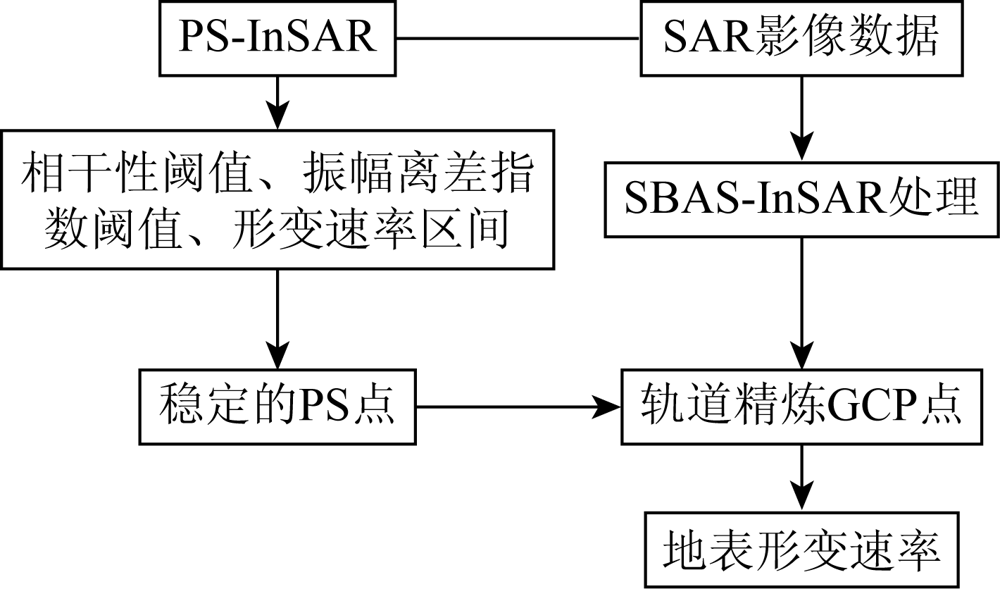
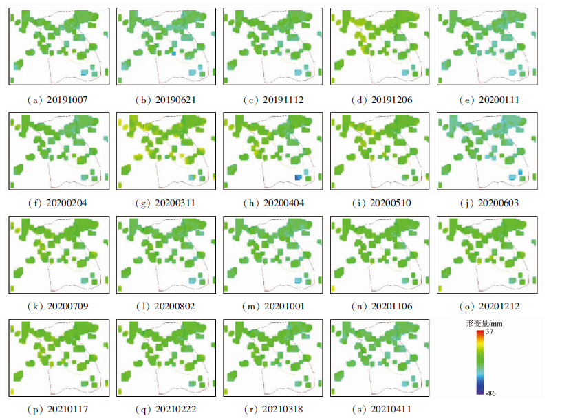
Abstract The signals of permanent scatterers can maintain high interferometric coherence for a long time. To solve the problem that manually selecting ground control points may affect the monitoring results during the orbit refinement of the SBAS-InSAR, this study combined permanent scatterers with SBAS-InSAR. Firstly, by setting the thresholds of the coherence coefficient, the amplitude dispersion index, and the surface deformation rate, this study selected robust permanent scatterers as the ground control points in the orbit refinement of the SBAS-InSAR in order to correct the accuracy of the monitoring results. Then, this study selected 20 scenes of Sentinel-1A dual-polarization images that covered Xima Town, Longli County, Guizhou Province from September 1, 2019 to April 11, 2021 as the main data source for surface deformation monitoring. Finally, this study compared the results obtained using the proposed method and those obtained through manually selecting ground control points with the displacement monitoring data of the Beidou satellite, concluding that the data obtained using the method proposed in this study were more accurate.
|
| Keywords
permanent scatterer
multi-threshold
SBAS-InSAR
ground control points
|
|
|
|
Corresponding Authors:
XIANG Xiqiong
E-mail: lxwei0608@163.com;tujia@126.com
|
|
Issue Date: 21 September 2022
|
|
|
| [1] |
曹翠华. InSAR技术监测西南喀斯特地表形变应用研究[D]. 西安: 西安科技大学, 2020.
|
| [1] |
Cao C H. Application of InSAR technology in monitoring southwest surface deformation[D]. Xi’an: Xi’an University of Science and Technology, 2020.
|
| [2] |
Colombo D, Farina P, Moretti S, et al. Land subsidence in the Firenze-Prato-Pistoia basin measured by means of spaceborne SAR interferometry[C]// IEEE International Symposium on Geoscience and Remote Sensing (IGARSS), 2003, 4(3):2927-2929.
|
| [3] |
Wu Q, Jia C T, Chen S B, et al. SBAS-InSAR based deformation detection of urban land,created from mega-scale mountain excavating and valley filling in the loess plateau:The case study of Yan’an City[J]. Remote Sensing, 2019, 11(14):1673.
doi: 10.3390/rs11141673
url: https://www.mdpi.com/2072-4292/11/14/1673
|
| [4] |
刘一霖, 张勤, 黄海军, 等. 矿区地表大量级沉陷形变短基线集InSAR监测分析[J]. 国土资源遥感, 2017, 29(2):144-151.doi: 10.6046/gtzyyg.2017.02.21.
doi: 10.6046/gtzyyg.2017.02.21
|
| [4] |
Liu Y L, Zhang Q, Huang H J, et al. Monitoring and analyzing large scale land subsidence over the mining area using small baseline subset InSAR[J]. Remote Sensing for Land and Resources, 2017, 29 (2) :144-151.doi: 10.6046/gtzyyg.2017.02.21.
doi: 10.6046/gtzyyg.2017.02.21
|
| [5] |
葛大庆, 殷跃平, 王艳, 等. 地面沉降-回弹及地下水位波动的InSAR长时序监测——以德州市为例[J]. 国土资源遥感, 2014, 26(1):103-109.doi: 10.6046/gtzyyg.2014.01.18.
doi: 10.6046/gtzyyg.2014.01.18
|
| [5] |
Ge D Q, Yin Y P, Wang Y, et al. Seasonal subsidence-rebound and ground water level changes monitoring by using coherent target InSAR technique:A case study of Dezhou,Shandong[J]. Remote Sensing for Land and Resources, 2014, 26(1):103-109.doi: 10.6046/gtzyyg.2014.01.18.
doi: 10.6046/gtzyyg.2014.01.18
|
| [6] |
李金超, 高飞, 鲁加国, 等. 基于SBAS-InSAR和GM-SVR的居民区形变监测与预测[J]. 大地测量与地球动力学, 2019, 39(8):837-842.
|
| [6] |
Li J C, Gao F, Lu J G, et al. Deformation monitoring and prediction of residential area based on SBAS-InSAR and GM-SVR[J]. Journal of Geodesy and Geodynamics, 2019, 39(8):837-842.
|
| [7] |
王道飘. 基于PS点大气延迟校正的时序InSAR在城市地面沉降监测中的研究及应用[D]. 武汉: 武汉理工大学, 2019.
|
| [7] |
Wang D P. Research and application of time series InSAR based on atmospheric delay correction by PS points in urban land settlement monitoring[D]. Wuhan: Wuhan University of Technology, 2019.
|
| [8] |
Li N, Wu J. Research on methods of high coherent target extraction in urban area based on PSINSAR technology[J]. ISPRS - International Archives of the Photogrammetry,Remote Sensing and Spatial Information Sciences, 2018, XLII-3 :901-908.
|
| [9] |
Ferretti A, Prati C, Rocca F. Analysis of permanent scatterers in SAR interferometry[C]// Proceedings of IEEE International Geoscience and Remote Sensing Symposium,Honolulu,HI, 2000.
|
| [10] |
李婉秋. 基于Sentinel-1数据的SBAS-InSAR技术在地表形变监测中的研究[D]. 成都: 成都理工大学, 2018.
|
| [10] |
Li W Q. A research of SBAS-InSAR technology based on sentinel-1 data in surface deformation monitoring[D]. Chengdu: Chengdu University of Technology, 2018.
|
| [11] |
周吕, 郭际明, 李昕, 等. 基于SBAS-InSAR的北京地区地表沉降监测与分析[J]. 大地测量与地球动力学, 2016, 36(9):793-797.
|
| [11] |
Zhou L, Guo J M, Li X, et al. Monitoring and analyzing on ground settlement in Beijing area based on SBAS-InSAR[J]. Journal of Geodesy and Geodynamics, 2016, 36(9):793-797.
|
| [12] |
Esri中国信息技术有限公司. SARscape培训教程[Z]. 北京: [s.n.], 2018.
|
| [12] |
Esri China Information Technology Co.,LTD. SARscape training tutorial[Z]. Beijing: [s.n.], 2018.
|
| [13] |
何平. 时序InSAR的误差分析及应用研究[D]. 武汉: 武汉大学, 2014.
|
| [13] |
He P. Error analysis and surface deformation application of time series InSAR[D]. Wuhan: Wuhan University, 2014.
|
|
Viewed |
|
|
|
Full text
|
|
|
|
|
Abstract
|
|
|
|
|
Cited |
|
|
|
|
| |
Shared |
|
|
|
|
| |
Discussed |
|
|
|
|
 2022,
Vol. 34
2022,
Vol. 34
 ), XIANG Xiqiong1(