|
|
 |
|

|
|
|
Time-series InSAR-based monitoring and analysis of surface deformation in the Axi mining area, Xinjiang |
HU Xiaoqiang1( ), YANG Shuwen1,2,3(), YAN Heng1, XUE Qing1, ZHANG Naixin1 ), YANG Shuwen1,2,3(), YAN Heng1, XUE Qing1, ZHANG Naixin1 |
1. Faculty of Geomatics, Lanzhou Jiaotong University, Lanzhou 730070, China
2. National-Local Joint Engineering Research Center of Technologies and Applications for National Geographic State Monitoring, Lanzhou 730070, China
3. Gansu Provincial Engineering Laboratory for National Geographic State Monitoring, Lanzhou 730070, China |
|
|
|
|
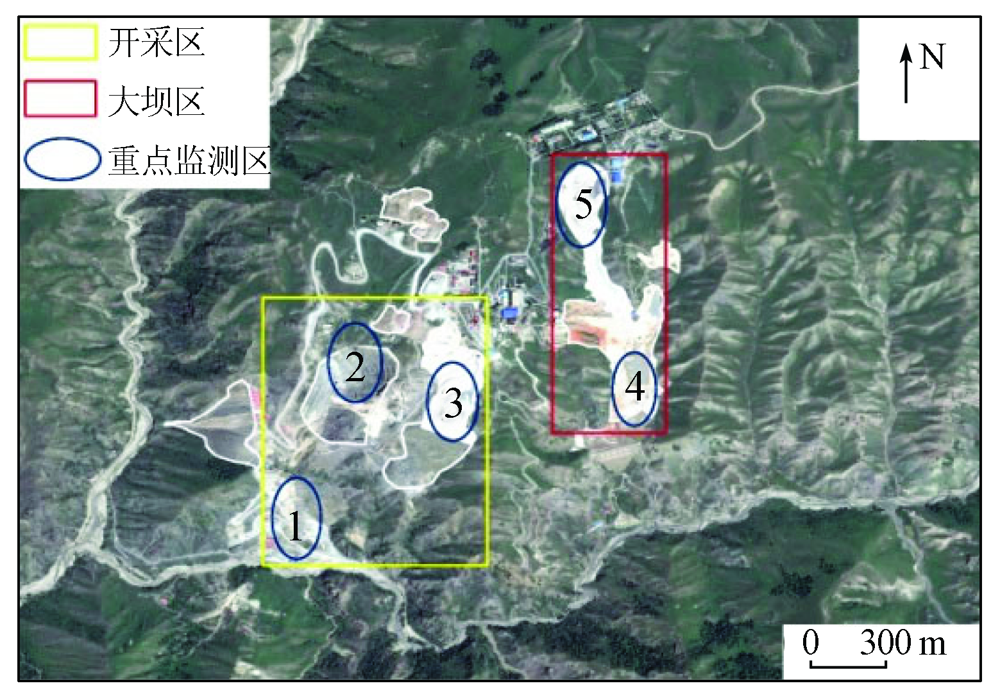
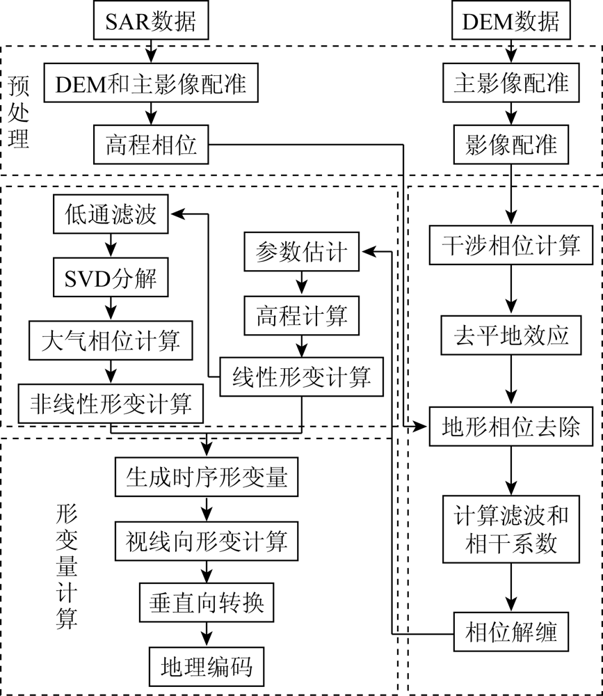
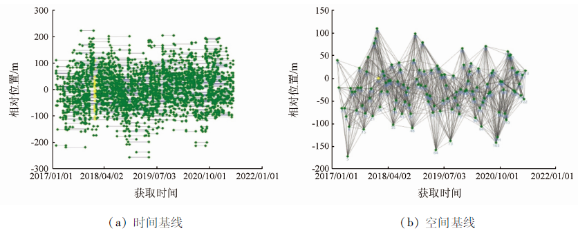
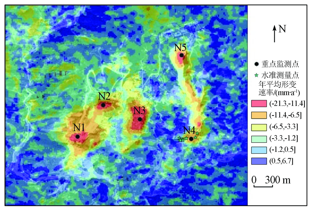
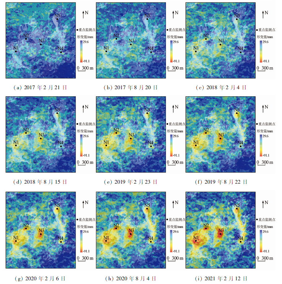
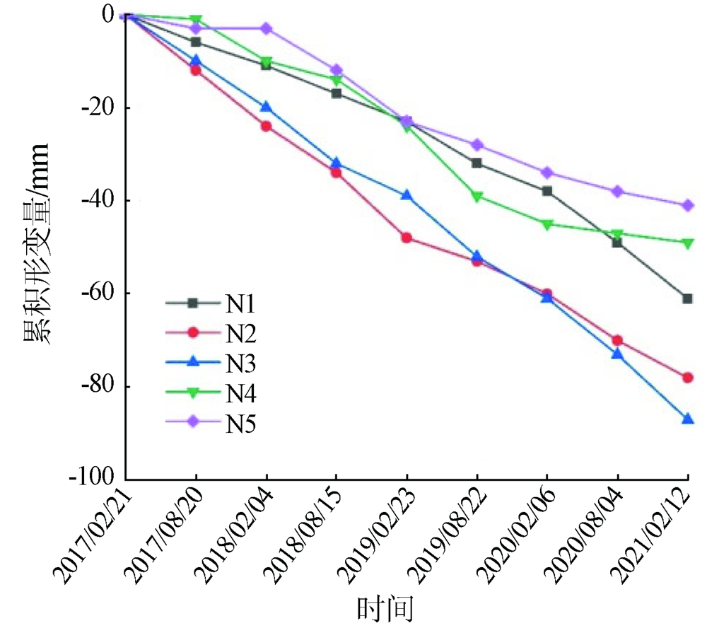
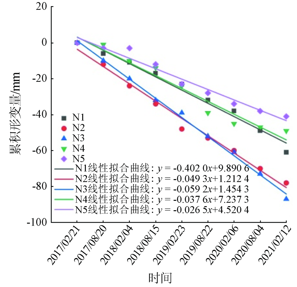
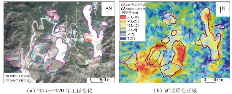
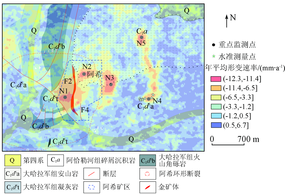
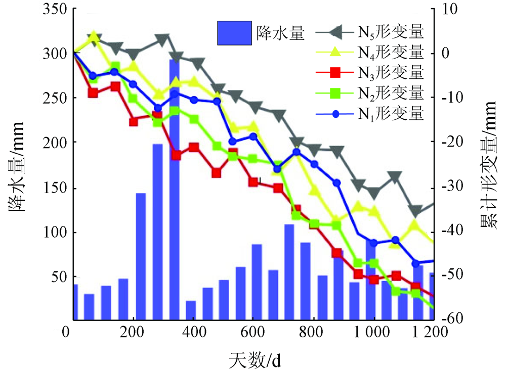
Abstract The Axi mining area in Xinjiang has a complex geographical environment. The long-term exploitation of mineral resources has caused severe ground subsidence and deformation in the mining area, as well as safety hazards of mining and production and the destruction of the surrounding ecological environment. This study aims to further investigate and analyze the spatial-temporal variation characteristics of the ground subsidence and the patterns of surface deformation in the Axi mining area. To this end, this study first calculated the land subsidence using the small baseline subset-interferometric synthetic aperture Radar (SBAS-InSAR) technique based on the 127 scenes descending Sentinel-1A images acquired from February 9, 2017 to April 25, 2021. Then, it compared the subsidence monitoring results obtained using the InSAR technique with the leveling results for verification. Finally, this study analyzed the spatial-temporal variation characteristics of land subsidence in the Axi mining area in recent five years and investigated the driving factors for the land subsidence. The results show that the surface deformation of the Axi mining area showed a roughly stable trend and significant local subsidence throughout the monitoring period. The main factors affecting the ground subsidence included mineral exploitation, geological structure, precipitation, and the impoundment of open-pit mines. This study will provide a scientific basis for ground subsidence monitoring and the future proper exploitation of underground minerals in the Axi mining area.
|
| Keywords
Axi mining area
SBAS-InSAR
land subsidence
spatial-temporal change monitoring
driving factor
|
|
|
|
Issue Date: 20 March 2023
|
|
|
| [1] |
李毅, 蒋金雄, 杜玉玲, 等. 融合分布式目标的矿区采动地表时序InSAR监测[J]. 中国矿业大学学报, 2020, 49(6):1199-1206,1232.
|
| [1] |
Li Y, Jiang J X, Du Y L, et al. Mining surface time series InSAR monitoring of mining area integrating distributed targets[J]. Journal of China University of Mining and Technology, 2020, 49(6):1199-1206,1232.
|
| [2] |
徐郡, 胡晋山, 康建荣, 等. 基于SBAS-InSAR的矿区村庄地面沉降监测与分析[J]. 金属矿山, 2019(10):74-80.
|
| [2] |
Xu J, Hu J S, Kang J R, et al. Monitoring and analysis of land subsidence of mining villages based on SBAS-InSAR[J]. Metal Mines, 2019(10):74-80.
|
| [3] |
许强, 蒲川豪, 赵宽耀, 等. 延安新区地面沉降时空演化特征时序InSAR监测与分析[J]. 武汉大学学报(信息科学版), 2021, 46(7):957-969.
|
| [3] |
Xu Q, Pu C H, Zhao K Y, et al. Temporal InSAR monitoring and analysis of temporal and spatial evolution characteristics of land subsidence in Yan’an new area[J]. Journal of Wuhan University (Information Science Edition), 2021, 46(7):957-969.
|
| [4] |
Shi M, Gong H L, Gao M L, et al. Recent ground subsidence in the North China Plain,China,revealed by Sentinel-1A datasets[J]. Remote Sensing, 2020, 12(21):2579.
doi: 10.3390/rs12162579
url: https://www.mdpi.com/2072-4292/12/16/2579
|
| [5] |
夏元平, 陈志轩, 张毅. 南昌市地面沉降InSAR监测及影响因子分析[J]. 测绘科学, 2020, 45(11):115-122,129.
|
| [5] |
Xia Y P, Chen Z X, Zhang Y. InSAR monitoring and impact factor analysis of land subsidence in Nanchang[J]. Surveying and Mapping Science, 2020, 45(11):115-122,129.
|
| [6] |
袁悦, 贾丽云, 张绪教, 等. 基于SBAS-InSAR技术的海口地区地面沉降监测及机理分析[J]. 地理与地理信息科学, 2020, 36(5):56-64.
|
| [6] |
Yuan Y, Jia L Y, Zhang X J, et al. Monitoring and mechanism analysis of land subsidence in Haikou area based on SBAS-InSAR technology[J]. Geography and Geographic Information Science, 2020, 36(5):56-64.
|
| [7] |
Dong L K, Wang C, Tang Y X, et al. Time series InSAR three-dimensional displacement inversion model of coal mining areas based on symmetrical features of mining subsidence[J]. Remote Sensing, 2021, 13(11):2143.
doi: 10.3390/rs13112143
url: https://www.mdpi.com/2072-4292/13/11/2143
|
| [8] |
Yang Q, Chang Z Q, Wang Y Q, et al. Ground deformation of Dongsheng mining area revealed by multi-temporal InSAR[C]// IOP Conference Series: Earth and Environmental Science.IOP Publishing, 2021, 675(1):012029.
|
| [9] |
Vassileva M, AlHalbouni D, Motagh M, et al. A decade-long silent ground subsidence hazard culminating in a metropolitan disaster in Maceió,Brazil[J]. Scientific Reports, 2021, 11(1):1-13.
doi: 10.1038/s41598-020-79139-8
|
| [10] |
王辉, 曾琪明, 焦健, 等. 结合序贯平差方法监测地表形变的InSAR时序分析技术[J]. 北京大学学报(自然科学版), 2021, 57(2):241-249.
|
| [10] |
Wang H, Zeng Q M, Jiao J, et al. InSAR time series analysis technology for monitoring surface deformation combined with sequential adjustment method[J]. Journal of Peking University (Natural Science Edition), 2021, 57(2):241-249.
|
| [11] |
魏聪敏, 葛伟鹏, 邵延秀, 等. 利用Sentinel-1A合成孔径雷达干涉时间序列监测陇东地区地面沉降变形[J]. 遥感技术与应用, 2020, 35(4):864-872.
|
| [11] |
Wei C M, Ge W P, Shao Y X, et al. Monitoring land subsidence and deformation in Longdong area using Sentinel-1A synthetic aperture Radar interferometric time series[J]. Remote Sensing Technology and Application, 2020, 35(4):864-872.
|
| [12] |
王海艳, 冯光财, 苗露, 等. InSAR视角下准噶尔盆地农业灌溉区地表形变特征和演化规律[J]. 遥感学报, 2020, 24(10):1233-1242.
|
| [12] |
Wang H Y, Feng G C, Miao L, et al. Surface deformation characteristics and evolution law of agricultural irrigation area in Junggar Basin from the perspective of InSAR[J]. Journal of Remote Sensing, 2020, 24(10):1233-1242.
|
| [13] |
Xu J M, Zhu W B, Xu J L, et al. High-intensity longwall mining-induced ground subsidence in Shendong coalfield,China[J]. International Journal of Rock Mechanics and Mining Sciences, 2021, 141:104730.
doi: 10.1016/j.ijrmms.2021.104730
url: https://linkinghub.elsevier.com/retrieve/pii/S1365160921001167
|
| [14] |
丁朋朋, 贾超, 韩瑶, 等. 时序InSAR技术的潍北平原地面沉降分析[J]. 测绘科学, 2021, 46(8):135-140.
|
| [14] |
Ding P P, Jia C, Han Y, et al. Land subsidence analysis of Weibei plain using time series InSAR technology[J]. Surveying and Mapping Science, 2021, 46(8):135-140.
|
| [15] |
施显健, 任超, 周吕, 等. InSAR填海区地铁沿线地表沉降反演分析[J]. 测绘科学, 2021, 46(2):146-151,164.
|
| [15] |
Shi X J, Ren C, Zhou L, et al. Inversion analysis of surface subsidence along subway in InSAR reclamation area[J]. Surveying and Mapping Science, 2021, 46(2):146-151,164.
|
| [16] |
任欣, 易加强. 新疆伊宁县地质灾害特征及其防治[J]. 西部探矿工程, 2014, 26(7):101-103.
|
| [16] |
Ren X, Yi J Q. Characteristics and prevention of geological disasters in Yining County,Xinjiang[J]. Western Exploration Engineering, 2014, 26(7):101-103.
|
| [17] |
王宝刚, 张晓斌, 张铭. 新疆阿希勒金矿床地质特征及找矿标志[J]. 陕西地质, 2018, 36(1):20-25.
|
| [17] |
Wang B G, Zhang X B, Zhang M. Geological characteristics and prospecting criteria of Axile gold deposit in Xinjiang[J]. Shanxi Geology, 2018, 36(1):20-25.
|
| [18] |
胡乐银, 张景发, 商晓青. SBAS-InSAR技术原理及其在地壳形变监测中的应用[J]. 地壳构造与地壳应力文集, 2010(1):82-89.
|
| [18] |
Hu L Y, Zhang J F, Shang X Q. Principle of SBAS-InSAR technology and its application in crustal deformation monitoring[J]. Collected Works of Crustal Structure and Crustal Stress, 2010(1):82-89.
|
| [19] |
李珊珊, 李志伟, 胡俊, 等. SBAS-InSAR技术监测青藏高原季节性冻土形变[J]. 地球物理学报, 2013, 56(5):1476-1486.
|
| [19] |
Li S S, Li Z W, Hu J, et al. Monitoring seasonal frozen soil deformation in Qinghai-Tibet Plateau by SBAS-InSAR technology[J]. Chinese Journal of Geophysics, 2013, 56(5):1476-1486.
|
| [20] |
董少春, 种亚辉, 胡欢, 等. 基于时序InSAR的常州市2015-2018年地面沉降监测[J]. 南京大学学报(自然科学), 2019, 55(3):370-380.
|
| [20] |
Dong S C, Zhong Y H, Hu H, et al. Land subsidence monitoring in Changzhou from 2015 to 2018 based on time series InSAR[J]. Journal of Nanjing University (Natural Science), 2019, 55(3):370-380.
|
| [21] |
曹发伟, 廖维谷. SBAS技术在矿区地面沉降监测中的应用[J]. 测绘通报, 2021(3):156-158,163.
|
| [21] |
Cao F W, Liao W G. Application of SBAS technology in land subsidence monitoring in mining area[J]. Surveying and Mapping Bulletin, 2021(3):156-158,163.
|
| [22] |
Amani M, Poncos V, Brisco B, et al. InSAR coherence analysis for wetlands in Alberta,Canada using time-series Sentinel-1 data[J]. Remote Sensing, 2021, 13(16):3315.
doi: 10.3390/rs13163315
url: https://www.mdpi.com/2072-4292/13/16/3315
|
| [23] |
Gong C G, Lei S G, Bian Z F, et al. Using time series InSAR to assess the deformation activity of open-pit mine dump site in severe cold area[J]. Journal of Soils and Sediments, 2021, 21(11):3717-3732.
doi: 10.1007/s11368-021-03040-8
|
| [24] |
Liu J H, Hu J, Bürgmann R, et al. A strain-model based InSAR time series method and its application to the Geysers Geothermal field,California[J]. Journal of Geophysical Research:Solid Earth, 2021, 126(8): e2021JB021939.
|
| [25] |
沙永莲, 王晓文, 刘国祥, 等. 基于SBAS InSAR的新疆哈密砂墩子煤田开采沉陷监测与反演[J]. 自然资源遥感, 2021, 33(3):194-201.doi:10.6046/zrzyyg.2020026.
doi: 10.6046/zrzyyg.2020026
|
| [25] |
Sha Y L, Wang X W, Liu G X, et al. SBAS-InSAR based monitoring and inversion of surface subsidence of the Shadunzi coal mine in Hami City,Xinjiang[J]. Remote Sensing for Natural Resources, 2021, 33(3):194-201.doi:10.6046/zrzyyg.2020026.
doi: 10.6046/zrzyyg.2020026
|
| [26] |
张扬. 武汉市地面沉降时空格局、驱动因子及水文效应研究[D]. 武汉: 武汉大学, 2019.
|
| [26] |
Zhang Y. Study on temporal and spatial pattern,driving factors and hydrological effects of land subsidence in Wuhan[D]. Wuhan: Wuhan University, 2019.
|
| [27] |
贺小平. 阿希金矿床地质特征及成因探讨[J]. 新疆有色金属, 2001(4):1-4.
|
| [27] |
He X P. Geological characteristics and genesis of Axi gold deposit[J]. Xinjiang Nonferrous Metals, 2001(4):1-4.
|
| [28] |
魏佳林, 曹新志, 王庆峰, 等. 新疆阿希金矿床黄铁矿标型特征及其地质意义[J]. 地质科技情报, 2011, 30(5):89-96.
|
| [28] |
Wei J L, Cao X Z, Wang Q F, et al. Typomorphic characteristics and geological significance of pyrite in Axi gold deposit,Xinjiang[J]. Geoscience and Technology Information, 2011, 30(5):89-96.
|
| [29] |
彭义伟, 顾雪祥, 章永梅, 等. 新疆阿希与塔吾尔别克金矿床的成因联系:来自流体包裹体、S-Pb同位素和黄铁矿热电性的证据[J]. 地质学报, 2020, 94(10):2919-2945.
|
| [29] |
Peng Y W, Gu X X, Zhang Y M, et al. Geochemical characteristics and prospecting potential of Xilaokou gold deposit,Shandong Province[J]. Acta Geological Sinica, 2020, 94(10):2919-2945.
|
| [30] |
李志忠. 浅谈新疆阿希金矿床地质特征及成矿机理[J]. 新疆有色金属, 2006(3):6-7.
|
| [30] |
Li Z Z. Geological characteristics and metallogenic mechanism of Axi gold deposit in Xinjiang[J]. Xinjiang Nonferrous Metals, 2006(3):6-7.
|
|
Viewed |
|
|
|
Full text
|
|
|
|
|
Abstract
|
|
|
|
|
Cited |
|
|
|
|
| |
Shared |
|
|
|
|
| |
Discussed |
|
|
|
|
 2023,
Vol. 35
2023,
Vol. 35