|
|
|
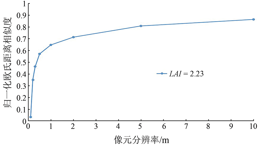
Abstract High spatial resolution remote sensing data serve as a new data source for quantitative remote sensing of vegetation, bringing in both new challenges and opportunities. The traditional leaf area index (LAI) inversion method based on the radiative transfer theory takes Beer-Lambert Law as the primary theoretical basis. The prerequisite for its application is that the leaf distribution in pixels follows a Poisson distribution. This study explored the appropriate scale in the case that the spatial distribution of continuous vegetation leaves in pixels follows a Poisson distribution. Focusing on the wheat canopy, this study used the LESS (LargE-Scale remote sensing data and image Simulation framework) software to simulate the remote sensing images of continuous wheat canopy. Based on this, this study analyzed the appropriate scale on which continuous wheat canopy leaves follow a Poisson distribution through the three-dimensional simulation of leaf canopy. Moreover, this study constructed a method for calculating the appropriate scale of the LAI inversion of continuous vegetation. The results show that the appropriate scale is influenced by the LAI value and the aggregation effect. The UAV hyperspectral data and the LAI inversion results from Luohe City, Henan Province validated the feasibility of this method.
|
| Keywords
high spatial resolution
LESS
appropriate scale
|
|
Corresponding Authors:
FAN Wenjie
E-mail: wuhb@pku.edu.cn;fanwj@pku.edu.cn
|
|
Issue Date: 20 June 2022
|
|
|
| [1] |
Ganopolski A, Kubatzki C, Claussen M, et al. The influence of Vegetation-Atmosphere-Ocean interaction on climate during the Mid-Holocene[J]. Science, 1998, 280(5371):1916-1919.
pmid: 9632385
|
| [2] |
Bonan G B, Pollard D, Thompson S L. Influence of subgrid-scale heterogeneity in leaf area index,stomatal resistance,and soil moisture on grid-scale land-atmosphere interactions[J]. Journal of Climate, 1993, 6(10):1882-1897.
doi: 10.1175/1520-0442(1993)006<1882:IOSSHI>2.0.CO;2
url: http://journals.ametsoc.org/doi/10.1175/1520-0442(1993)006<1882:IOSSHI>2.0.CO;2
|
| [3] |
Baret F, Guyot G. Potentials and limits of vegetation indices for LAI and APAR assessment[J]. Remote Sensing of Environment, 1991, 35(2-3): 161-173
doi: 10.1016/0034-4257(91)90009-U
url: https://linkinghub.elsevier.com/retrieve/pii/003442579190009U
|
| [4] |
Bonan G B. Land-Atmosphere interactions for climate system Models: Coupling biophysical,biogeochemical,and ecosystem dynamical processes[J]. Remote Sensing of Environment, 1995, 51(1):57-73
doi: 10.1016/0034-4257(94)00065-U
url: https://linkinghub.elsevier.com/retrieve/pii/003442579400065U
|
| [5] |
Tang H, Brolly M, Zhao F, et al. Deriving and validating leaf area index (LAI) at multiple spatial scales through lidar remote sensing:A case study in Sierra National Forest,CA[J]. Remote Sensing of Environment, 2014, 143:131-141.
doi: 10.1016/j.rse.2013.12.007
url: https://linkinghub.elsevier.com/retrieve/pii/S0034425713004471
|
| [6] |
Shi Y, Wang J, Qin J, et al. An upscaling algorithm to obtain the representative ground truth of LAI time series in heterogeneous land surface[J]. Remote Sensing, 2015, 7(10):12887-12908.
doi: 10.3390/rs71012887
url: http://www.mdpi.com/2072-4292/7/10/12887
|
| [7] |
José G D, Philip L, Mathias D. Efficient emulation of radiative transfer codes using gaussian processes and application to land surface parameter inferences[J]. Remote Sensing, 2016, 8(2):1-32.
doi: 10.3390/rs8010001
url: http://www.mdpi.com/2072-4292/8/1/1
|
| [8] |
Lisein J, Bonnet S, Lejeune P, et al. Modélisation de la canopée forestière par photogrammétrie depuis des images acquises par drone[J]. Revue Francaise De Photogrammetrie Et De Teledetection, 2014, 206(206):45-54.
|
| [9] |
陶雪涛. 线性模型下多通道遥感图像混合像元分解方法研究[J]. 上海: 复旦大学, 2008, 14:31-41.
|
| [9] |
Tao X T. Research on the decomposition method of multi-channel remote sensing image mixed pixels under linear model[J]. Shanghai:Fudan University, 2008, 14:31-41.
|
| [10] |
胡潭高, 张锦水, 贾斌, 等. 不同分辨率遥感图像混合像元线性分解方法研究[J]. 地理与地理信息科学, 2008, 24(3):20-23.
|
| [10] |
Hu T G, Zhang J S, Jia B, et al. Research on the linear decomposition method of mixed pixels of remote sensing images with different resolutions[J]. Geography and Geo-Information Science, 2008, 24(3):20-23.
|
| [11] |
Tian J, Le W, Li X, et al. Comparison of UAV and WorldView-2 imagery for mapping leaf area index of mangrove forest[J]. International Journal of Applied Earth Observation & Geoinformation, 2017, 61:22-31.
|
| [12] |
Kimura K, Yamasaki S. Accurate root length and diameter measurement using NIH Image:Use of Pythagorean distance for diameter estimation[J]. Plant & Soil, 2003, 254(2):305-315.
|
| [13] |
Li W, Niu Z, Chen H, et al. Characterizing canopy structural complexity for the estimation of maize LAI based on ALS data and UAV stereo images[J]. International Journal of Remote Sensing, 2017, 38(8-10):1-11.
|
| [14] |
李小文, 王锦地. 植被光学遥感模型和植被结构参数化[M]. 北京: 科学出版社, 1995,118.
|
| [14] |
Li X W, Wang J D. Vegetation optical remote sensing model and vegetation structure parameterization[M]. Beijing: Science Press, 1995,118.
|
| [15] |
唐凤莉, 刘良云. 冠层特征尺度的定量计算模型与方法[J]. 遥感学报, 2014, 18(6):1182-1188.
|
| [15] |
Tang F L, Liu L Y. Canopy characteristic scale model and quantitative calculation[J]. Journal of Remote Sensing, 2014, 18(6):1182-1188.
|
| [16] |
Qi J, Xie D, Yin T, et al. LESS:LargE-Scale remote sensing data and image simulation framework over heterogeneous 3D scenes[J]. Remote Sensing of Environment, 2019, 221:695-706.
doi: 10.1016/j.rse.2018.11.036
url: https://linkinghub.elsevier.com/retrieve/pii/S0034425718305443
|
| [17] |
徐玉华, 曾明. 泊松分布性质及应用研究[J]. 长江大学学报, 2006(4):132-133.
|
| [17] |
Xu Y H, Zeng M. Poisson distribution properties and application research[J]. Journal of Yangtze University, 2006(4):132-133.
|
| [18] |
Cheung G W, Rensvold R B. Evaluating Goodness-of-Fit indexes for testing measurement invariance[J]. Structural Equation Modeling, 2002, 9(2):233-255.
doi: 10.1207/S15328007SEM0902_5
url: http://www.tandfonline.com/doi/abs/10.1207/S15328007SEM0902_5
|
| [19] |
罗忠良. 基于案例推理系统中案例检索算法的探索[J]. 计算机工程与应用, 2005, 41(25):230-232.
|
| [19] |
Luo Z L. Exploration of case retrieval algorithms in case-based reasoning systems[J]. Computer Engineering and Applications, 2005, 41(25):230-232.
|
| [20] |
Bicheron P. A method of biophysical parameter retrieval at global scale by inversion of a vegetation reflectance model[J]. Remote Sensing of Environment, 1999, 67(3):251-266.
doi: 10.1016/S0034-4257(98)00083-2
url: https://linkinghub.elsevier.com/retrieve/pii/S0034425798000832
|
| [21] |
Ejegwa P A, Akubo A J, Joshua O M. Intuitionistic fuzzy set and its application in career determination via normalized euclidean distance method[J]. European Scientific Journal, 2014:69-77.
|
| [22] |
方杰, 张敏强, 李晓鹏. 中介效应的三类区间估计方法[J]. 心理科学进展, 2011, 19(5):765-774.
|
| [22] |
Fang J, Zhang M Q, Li X P. Three types of interval estimation methods for mediating effects[J]. Advances in Psychological Science, 2011, 19(5):765-774.
|
| [23] |
Fan W J, Xu X R. A method for blind separation of components information from mixed pixel[J]. Progress in Natural Science, 2006(16):760-765.
|
| [24] |
Fan W J, Xu X R, Liu X, et al. Accurate LAI retrieval method based on PROBA/CHRIS data[J]. Hydrology and Earth System Sciences Discussions, 2009, 6(6):7001-7024.
|
|
Viewed |
|
|
|
Full text
|
|
|
|
|
Abstract
|
|
|
|
|
Cited |
|
|
|
|
| |
Shared |
|
|
|
|
| |
Discussed |
|
|
|
|
 2022,
Vol. 34
2022,
Vol. 34
 ), WU Mengtong, YANG Siqi, FAN Wenjie(