|
|
|
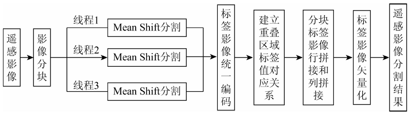
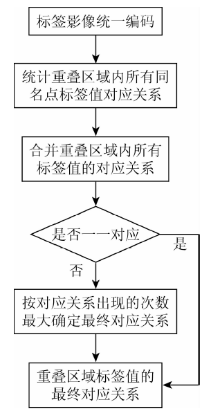
Abstract Mean Shift algorithm has been widely used in image segmentation because of its fast convergence speed and good segmentation accuracy. However, when large scale remote sensing images are processed, Mean Shift algorithm has some problems, such as slow speed and low efficiency. In this paper, a parallel seamless segmentation algorithm based on Mean Shift is proposed. The algorithm is based on block parallel Mean Shift segmentation. The elimination criterion of block lines is determined by uniform coding of label images and establishing corresponding relations between label values of overlapping regions. Then, the row and column directions of the label image are stitched together. Finally, the segmented label image is vectorized to generate the final segmentation result. Compared with the original Mean Shift algorithm, the algorithm put forward in this paper can not only ensure the reliability of segmentation results but also greatly improve the efficiency of image segmentation, and can also solve the problem of large scale remote sensing image segmentation.
|
| Keywords
Mean Shift algorithm
image segmentation
parallel computing
overlapping area
seamless stitch
|
|
|
|
Corresponding Authors:
Zongwei WANG
E-mail: wangzongwei328@163.com
|
|
Issue Date: 14 March 2020
|
|
|
| [1] |
刘大伟 . 高分辨率遥感影像分割方法及应用研究[D]. 西安:长安大学, 2016.
|
| [1] |
Liu D W . Study on Segmentation Algorithms and Its Applications of High Spatial Resolution Remote Sensing Images[D]. Xi’an:Chang’an University, 2016.
|
| [2] |
苏腾飞, 张圣微, 李洪玉 . 基于超像素MRF的农田地区高分遥感影像分割[J]. 国土资源遥感, 2018,30(1):37-44.doi: 10.6046/gtzyyg.2018.01.06.
|
| [2] |
Su T F, Zhang S W, Li H Y . High resolution remote sensing image segmentation using super-pixel MRF for agricultural area[J]. Remote Sensing for Land and Resources, 2018,30(1):37-44.doi: 10.6046/gtzyyg.2018.01.06.
|
| [3] |
Fang H, Chen Y, Li L , et al. Implementation of the parallel mean shift-based image segmentation algorithm on a GPU cluster[J]. International Journal of Digital Earth, 2018(5):1-26.
|
| [4] |
Achanta R, Shaji A, Smith K , et al. SLIC superpixels[R]. Lausanne:Swissfederal Institute of Technology, 2010.
|
| [5] |
沈夏炯, 吴晓洋, 韩道军 . 分水岭分割算法研究综述[J]. 计算机工程, 2015,41(10):26-30.
|
| [5] |
Shen X J, Wu X Y, Han D J . Survey of research on watershed segmentation algorithms[J]. Compute Engineering, 2015,41(10):26-30.
|
| [6] |
王露, 刘庆元 . 高分辨率遥感影像多尺度分割中最优尺度选取方法综述[J]. 测绘与空间地理信息, 2015,38(3):166-169.
|
| [6] |
Wang L, Liu Q Y . The methods summary of optimal segmentation scale selection in high-resolution remote sensing images multi-scale segmentation[J]. Geomatics and Spatial Information Technology, 2015,38(3):166-169.
|
| [7] |
沈占锋, 骆剑承, 吴炜 , 等. 遥感影像均值漂移分割算法的并行化实现[J]. 哈尔滨工业大学学报, 2010,42(5):811-815.
|
| [7] |
Shen Z F, Luo J C, Wu W , et al. Implementation of parallelization of mean-shift algorithm formulti-scale segmentation of remote sensing images[J]. Journal of Harbin Institute of Technology, 2010,42(5):811-815.
|
| [8] |
Zhuge Y, Cao Y, Udupa J K , et al. Parallel fuzzy connected image segmentation on GPU[J]. Medical Physics, 2011,38(7):4365-4371.
|
| [9] |
胡晓东, 骆剑承, 沈占锋 , 等. 高分辨率遥感影像并行分割结果缝合算法[J]. 遥感学报, 2010,14(5):917-927.
|
| [9] |
Hu X D, Luo J C, Shen Z F , et al. Data sewing algorithm for parallel segmentation of high-resolution remotely sensed image[J]. Journal of Remote Sensing, 2010,14(5):917-927.
|
| [10] |
丁翠, 杨云涛, 张建 . 遥感影像并行分割的无缝拼接算法[J]. 测绘科学, 2017,42(4):34-38.
|
| [10] |
Ding C, Yang Y T, Zhang J . A seamless mosaic algorithm for remote sensing image parallel segmentation[J]. Science of Surveying and Mapping, 2017,42(4):34-38.
|
| [11] |
Fukunaga K, Hostetler L . The estimation of the gradient of a density function,with applications in pattern recognition[J]. IEEE Transactions on Information Theory, 1975,21(1):32-40.
|
| [12] |
Cheng Y Z . Mean shift,mode seeking,and clustering[J]. IEEE Transactions on Pattern Analysis and Machine Intelligence, 1995,17(8):790-799.
|
| [13] |
王卫红, 徐文涛, 夏列钢 , 等. 大规模遥感影像Mean Shift并行分割优化算法研究[J]. 小型微型计算机系统, 2015,36(5):1085-1090.
|
| [13] |
Wang W H, Xu W T, Xia L G , et al. Study for parallel segmentation optimization algorithm of Mean Shift in large-scale remote sensing image[J]. Journal of Chinese Compute Systems, 2015,36(5):1085-1090.
|
| [14] |
王更 . 高分辨率遥感影像多尺度分割算法研究与应用[D]. 徐州:中国矿业大学, 2016.
|
| [14] |
Wang G . Research and Application of Multi-Scale Segmentation for High-Resolution Remote Sensing Image[D]. Xuzhou:China University Mining Technology, 2016.
|
| [15] |
陆冬华, 赵英俊, 张东辉 , 等. 单机多核计算机环境下的遥感图像并行处理技术[J]. 地理空间信息, 2018,16(11):55-59.
|
| [15] |
Lu D H, Zhao Y J, Zhang D H , et al. Parallel processing technology of remote sensing images in single machine multi-core computer environment[J]. Geospatial Information, 2018,16(11):55-59.
|
| [16] |
金良益 . 遥感影像矢量化中多边形数据优化处理技术研究[D]. 郑州:解放军信息工程大学, 2017.
|
| [16] |
Jin L Y . Research on Optimization of Polygon Data in Remote Sensing Image[D]. Zhengzhou:Information Engineering University, 2017.
|
|
Viewed |
|
|
|
Full text
|
|
|
|
|
Abstract
|
|
|
|
|
Cited |
|
|
|
|
| |
Shared |
|
|
|
|
| |
Discussed |
|
|
|
|
 2020,
Vol. 32
2020,
Vol. 32
 )
)