|
|
 |
|

|
|
|
High spatial resolution automatic detection of bridges with high spatial resolution remote sensing images based on random erasure and YOLOv4 |
SUN Yu1( ), HUANG Liang1,2(), ZHAO Junsan1,3,4, CHANG Jun5, CHEN Pengdi1, CHENG Feifei1 ), HUANG Liang1,2(), ZHAO Junsan1,3,4, CHANG Jun5, CHEN Pengdi1, CHENG Feifei1 |
1. Faculty of Land Resource Engineering, Kunming University of Science and Technology, Kunming 650093, China
2. Surveying and Mapping Geo-Informatics Technology Research Center on Plateau Mountains of Yunnan Higher Education, Kunming 650093, China
3. Key Laboratory of Geospatial Information Integration Innovation for Smart Mines, Kunming 650093, China
4. Spatial Information Integration Technology of Natural Resources in Universities of Yunnan Province, Kunming 650211, China
5. The First Geodetic Surveying Brigade of Ministry of Natural Resources, Xi’an 710054, China |
|
|
|
|
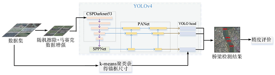
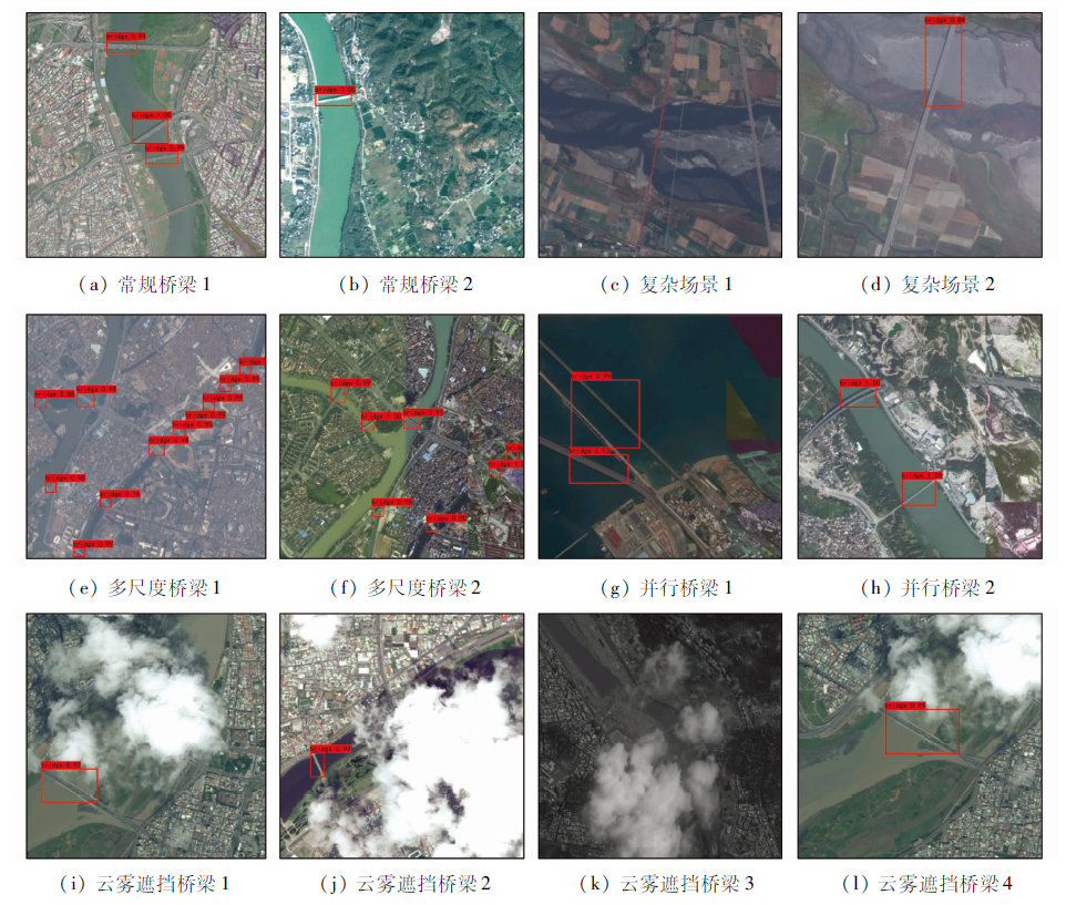
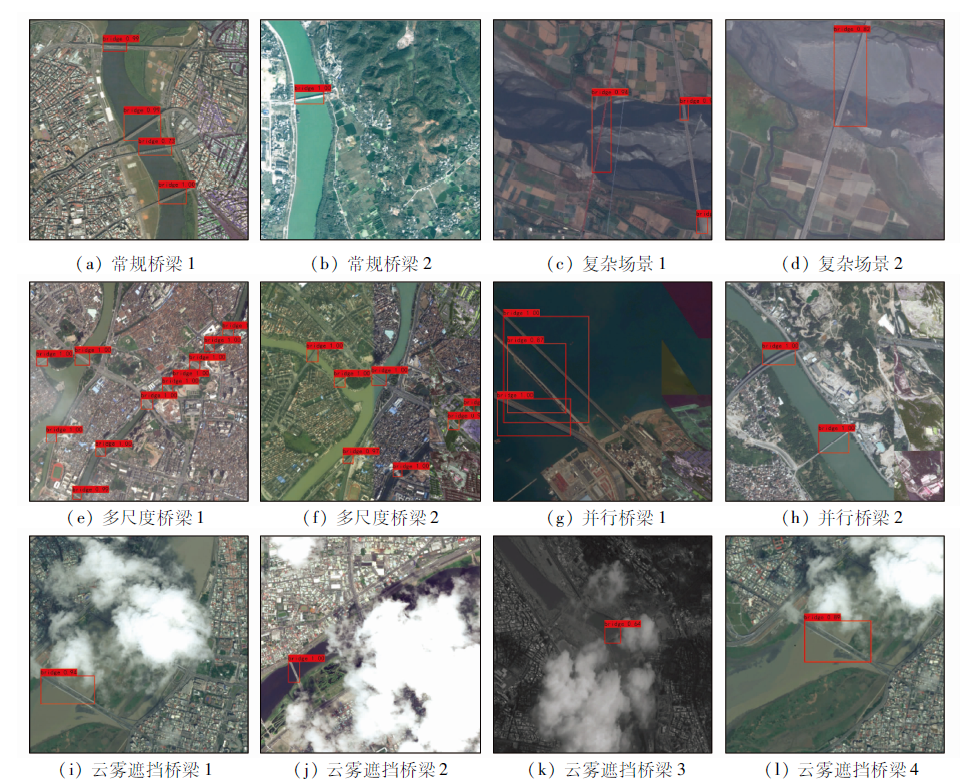
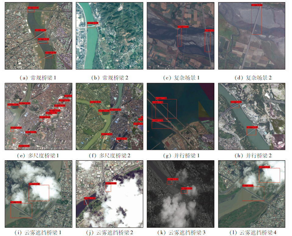
Abstract As a typical and important ground target, the bridge is the vital passage between transportation lines, so automatic detection of a bridge is of great social and economic significance. Deep learning has become a new way of bridge detection, but the detection accuracy for bridges obscured by cloud and mist is low. In order to solve this problem, an automatic bridge target detection method combining Random erase (RE) data enhancement and the YOLOv4 model is proposed: firstly, the scale range of the target in the data set is determined, and the candidate frame size is obtained by K-means clustering; secondly, the cloud obscuration is simulated by a combination of RE and mosaic data enhancement; thirdly, the enhanced data set is trained by YOLOv4 network; and finally, the mean Average Precision (mAP) is used to evaluate the experimental results. The experimental results show that the detection accuracy obtained by mAP is 97.06%, which is 2.99% higher than that of traditional YOLOv4, and the average detection accuracy of bridges obscured by a cloud is improved by 12%, which verifies the effectiveness and practicability of the proposed method.
|
| Keywords
deep learning
object detection
high spatial resolution remote sensing image
bridge detection
YOLOv4 network
|
|
|
|
Corresponding Authors:
HUANG Liang
E-mail: sunyu_kust@163.com;kmhuangliang@163.com
|
|
Issue Date: 20 June 2022
|
|
|
| [1] |
崔东顺. 可见光航拍图像水上桥梁检测算法研究[D]. 北京: 北京理工大学, 2015.
|
| [1] |
Cui D S. Research on visible light aerial image bridge detection algorithm master of science[D]. Beijing: Beijing Institute of Technology, 2015.
|
| [2] |
Baker D C, Hwang S S, Aggarwal J K. Detection and segmentation of man-made objects in outdoor scenes:Concrete bridges[J]. Journal of the Optical Society of America, 1989, 6(6):938-950.
|
| [3] |
谭向程, 安道祥, 陈乐平, 等. 一种基于极化圆周SAR图像的陆上桥梁提取方法[J]. 雷达学报, 2021, 10(3):402-415.
|
| [3] |
Tan X C, An D X, Chen L P, et al. A method of land bridge extraction based on polarized circumferential SAR image[J]. Chinese Journal of Radar, 2021, 10(3):402-415.
|
| [4] |
赵江洪, 张晓光, 杨璐, 等. 深度学习的遥感影像舰船目标检测[J]. 测绘科学, 2020, 45(3):110-116,134.
|
| [4] |
Zhao J H, Zhang X G, Yang L, et al. Deep learning for ship target detection in remote sensing images[J]. Science of Surveying and Mapping, 2020, 45(3):110-116,134.
|
| [5] |
李淑敏, 冯权泷, 梁其椿, 等. 基于深度学习的国产高分遥感影像飞机目标自动检测[J]. 遥感技术与应用, 2018, 33(6):1095-1102.
|
| [5] |
Li S M, Feng Q L, Liang Q C, et al. Automatic detection of aircraft targets in domestic high-resolution remote sensing images based on deep learning[J]. Remote Sensing Technology and Application, 2018, 33(6):1095-1102.
|
| [6] |
陈朋弟, 黄亮, 夏炎, 等. 基于Mask R-CNN的无人机影像路面交通标志检测与识别[J]. 国土资源遥感, 2020, 32(4):61-67.doi: 10.6046/gtzyyg.2020.04.09.
doi: 10.6046/gtzyyg.2020.04.09
|
| [6] |
Chen P D, Huang L, Xia Y, et al. Detection and recognition of traffic signing based on Mask R-CNN image using UAV[J]. Remote Sensing of Land and Resources, 2020, 32(4):61-67.doi: 10.6046/gtzyyg.2020.04.09.
doi: 10.6046/gtzyyg.2020.04.09
|
| [7] |
Chen L, Weng T, Xing J, et al. A new deep learning network for automatic bridge detection from SAR images based on balanced and attention mechanism[J]. Remote Sensing, 2020, 12 (3):441.
doi: 10.3390/rs12030441
url: https://www.mdpi.com/2072-4292/12/3/441
|
| [8] |
Lomenie N, Barbeau J. Integrating textural and geometric information for an automatic bridge detection system[C]// IGARSS 2003,2003 IEEE International Geoscience and Remote Sensing Symposium.Toulouse:IEEE, 2003:3952-3954.
|
| [9] |
杨浩, 尹东, 洪日昌. 高分辨率遥感图像中桥梁自动识别方法研究[J]. 计算机仿真, 2006, 22(9):119-122.
|
| [9] |
Yang H, Yin D, Hong R C. Research on automatic bridge identification method in high resolution remote sensing images[J]. Computer Simulation, 2006, 22(9):119-122.
|
| [10] |
陈爱军. 大幅面卫星遥感图像中桥梁识别算法[J]. 计算机仿真, 2014, 31(6):362-366.
|
| [10] |
Chen A J. Bridge recognition algorithm in large-scale satellite remote sensing images[J]. Computer Simulation, 2014, 31(6):362-366.
|
| [11] |
Hao X, Zhang G, Ma S. Deep learning[J]. International Journal of Semantic Computing, 2016, 10(3):417-439.
doi: 10.1142/S1793351X16500045
url: https://www.worldscientific.com/doi/abs/10.1142/S1793351X16500045
|
| [12] |
Girshick R, Donahue J, Darrell T, et al. Rich feature hierarchies for accurate object detection and semantic segmentation[C]// 2014 IEEE Conference on Computer Vision and Pattern Recognition.Columbus:IEEE, 2014:580-587.
|
| [13] |
Girshick R. Fast R-CNN[C]// 2015 IEEE International Conference on Computer Vision (ICCV).Santiago:IEEE, 2015:1440-1448.
|
| [14] |
Ren S, He K, Girshick R, et al. Faster R-CNN:Towards real-time object detection with region proposal networks[J]. IEEE Transactions on Pattern Analysis and Machine Intelligence, 2015, 39(6):1137-1149.
doi: 10.1109/TPAMI.2016.2577031
url: http://ieeexplore.ieee.org/document/7485869/
|
| [15] |
Liu W, Anguelov D, Erhan D, et al. Ssd:Single shot multibox detector[J]. European Conference on Computer Vision, 2016, 9905:21-37.
|
| [16] |
Redmon J, Divvala S, Girshick R, et al. You only look once:Unified,real-time object detection[C]// 2016 IEEE Conference on Computer Vision and Pattern Recognition (CVPR). Las Vegas: IEEE, 2016:779-788.
|
| [17] |
Redmon J, Farhadi A. YOLO9000:Better,faster,stronger[C]// 2017 IEEE Conference on Computer Vision and Pattern Recognition (CVPR).Honolulu:IEEE, 2017:6517-6525.
|
| [18] |
Redmon J, Farhadi A. YOLOv3:An incremental improvement[EB/OL].(2018-04-08).[2021-03-30]. https://pjreddie.com/media/files/papers/YOLOv3.pdf.
url: https://pjreddie.com/media/files/papers/YOLOv3.pdf
|
| [19] |
Bochkovskiy A, Wang C Y, Liao H Y M. Yolov4:Optimal speed and accuracy of object detection[J]. arXiv Preprint arXiv: 2020, 2004:10934.
|
| [20] |
2020 Gaofen challenge on automated high-resolution earth observation image interpretation[EB/OL]. Online: http://en.sw.chreos.org.
url: http://en.sw.chreos.org
|
| [21] |
Zhong Z, Zheng L, Kang G, et al. Random erasing data augmentation[J]. Proceedings of the AAAI Conference on Artificial Intelligence, 2017, 34 (7):13001-13008.
doi: 10.1609/aaai.v34i07.7000
url: https://aaai.org/ojs/index.php/AAAI/article/view/7000
|
| [22] |
Wang C Y, Liao H Y M, Wu Y H, et al. CSPNet:A new backbone that can enhance learning capability of CNN[C]// 2020 IEEE/CVF Conference on Computer Vision and Pattern Recognition Workshops (CVPRW).Seattle:IEEE, 2020:1571-1580.
|
|
Viewed |
|
|
|
Full text
|
|
|
|
|
Abstract
|
|
|
|
|
Cited |
|
|
|
|
| |
Shared |
|
|
|
|
| |
Discussed |
|
|
|
|
 2022,
Vol. 34
2022,
Vol. 34