|
|
 |
|

|
|
|
Assessment of the comprehensive disaster risk in rural areas based on multi-model comparison: A case study of Huayuan County, Hunan Province |
ZOU Fang1,2( ), MA Yunfei1, HU Yingling1 ), MA Yunfei1, HU Yingling1 |
1. Department of Urban and Rural Planning, Changsha University of Science and Technology, Changsha 410001, China
2. Rural Security Institute, Changsha University of Science and Technology, Changsha 410001, China |
|
|
|
|
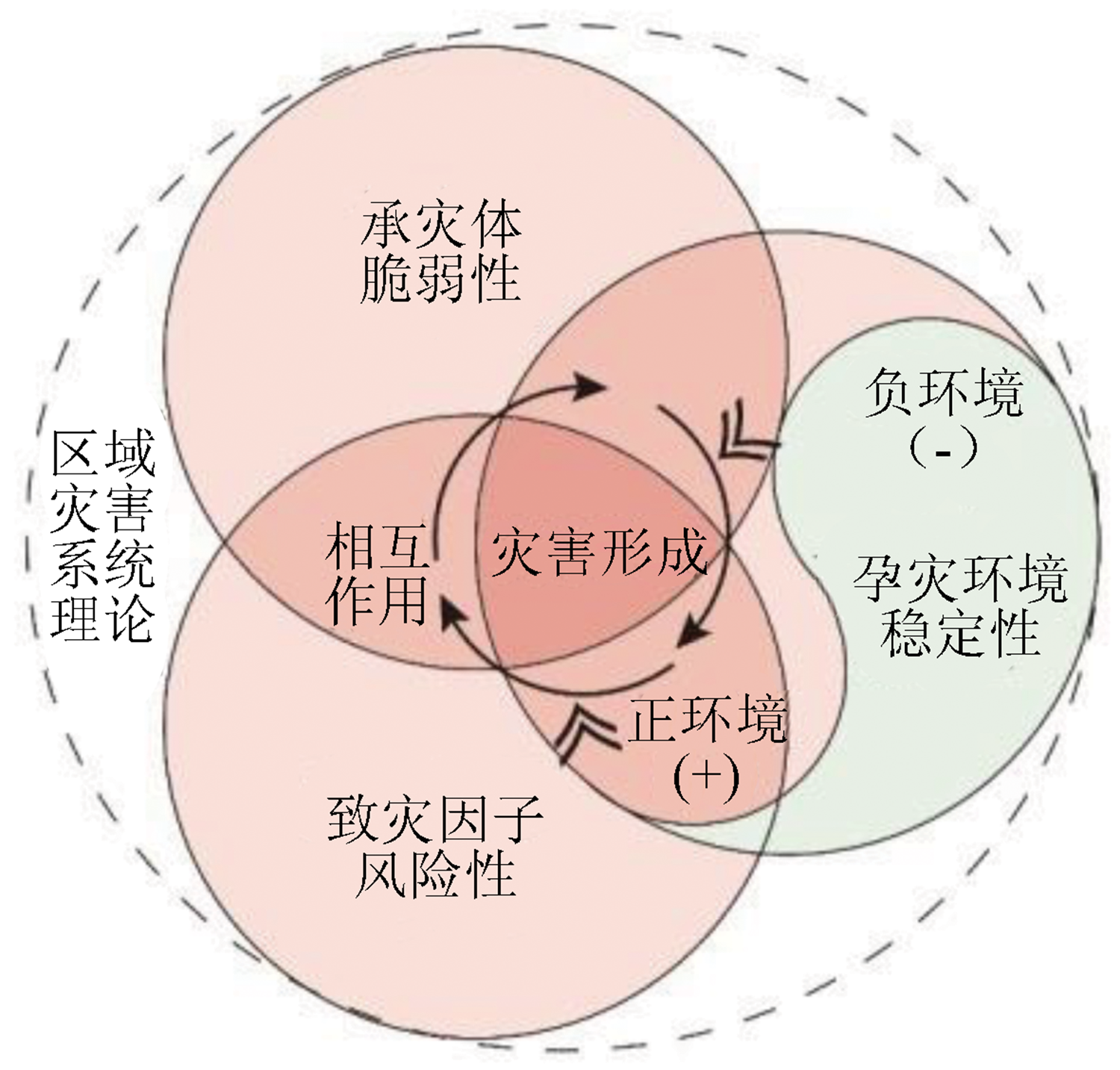
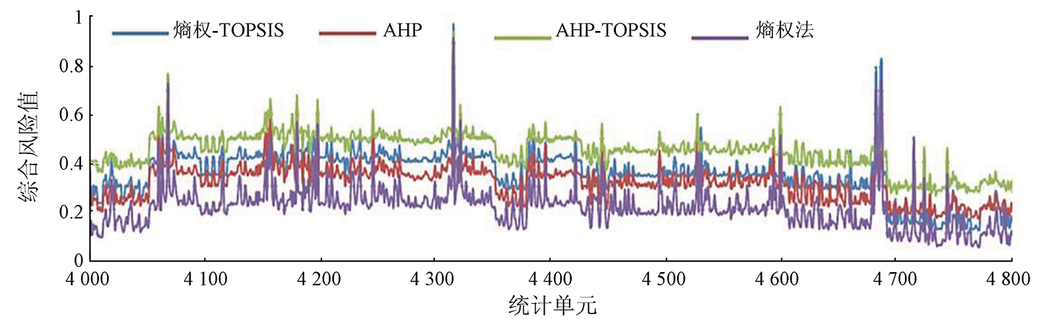
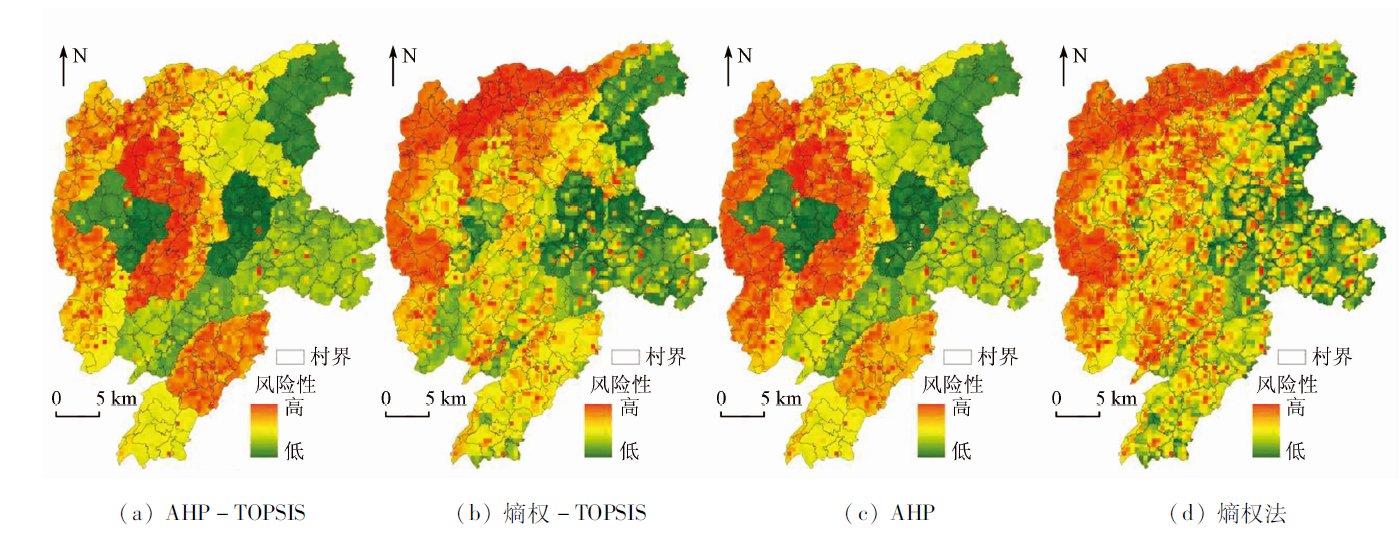
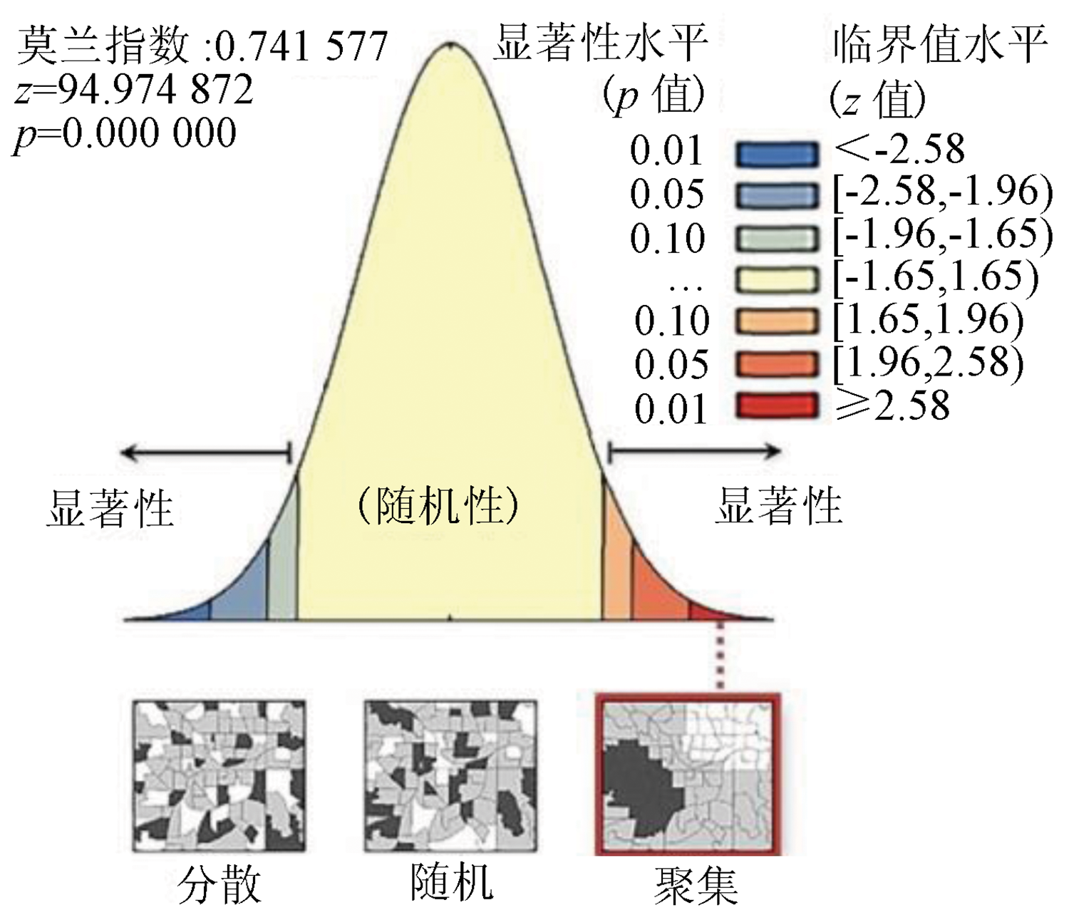
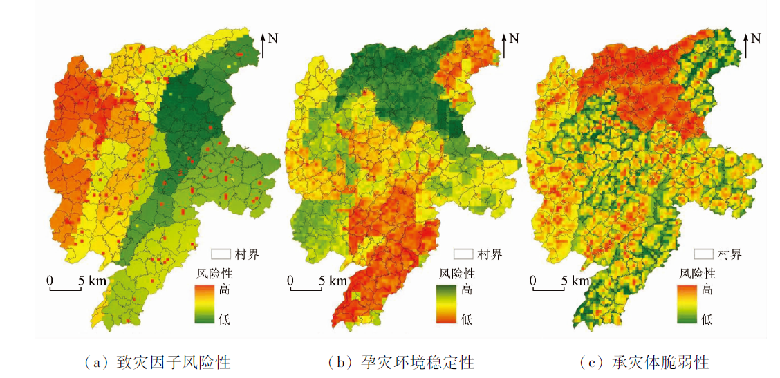
Abstract Frequent disasters continue to plague many rural areas, and the precise identification of the comprehensive disaster risk in rural areas is critical to disaster prevention and mitigation. With 232 villages in Huayuan County, Hunan Province as a case study, this study defined the comprehensive disaster risk index (CDSI) and constructed an assessment system reflecting the dynamics of disaster-inducing environment based on the three elements of risk formation stated in the regional disaster system theory. Then, this study investigated the comprehensive disaster risk in rural areas by comparing four models, namely the analytic hierarchy process - technique for order preference by similarity to ideal solution (AHP-TOPSIS), the entropy- TOPSIS, AHP, and the entropy weight method. The conclusions are as follows. The multi-model evaluation results show a positive correlation, with a CDSI ratio of 1:0.877:0.740:0.539. The entropy-TOPSIS model is the optimal model for the assessment of comprehensive disaster risk in the study area. The CDSI of the study area has a Moran’s I value of 0.74, a strong spatial autocorrelation, and spatial distribution characteristics of being high in the west, low in the east, and significant locally. This study deepens the assessment of comprehensive disaster risk in rural areas. It will provide practical experience and a theoretical basis for scientifically guiding rural disaster prevention and mitigation and ensuring the safe implementation of the rural revitalization strategy.
|
| Keywords
comprehensive disaster risk
rural area safty
entropy-TOPSIS
disaster prevention and reduction
|
|
|
|
Issue Date: 27 December 2022
|
|
|
| [1] |
Zhan Q M, Zou F, Zhang W S, et al. Research and practice on disaster prevention planning in villages based on planning support system[J]. International Review for Spatial Planning and Sustainable Development, 2018, 6(4):110-127.
|
| [2] |
Zou F, Zhan Q M, Zhang W S. Quantifying the impact of human activities on geological hazards in mountainous areas:Evidence from Shennongjia,China[J]. Natural Hazards, 2018, 90(1):137-155.
doi: 10.1007/s11069-017-3039-4
url: http://link.springer.com/10.1007/s11069-017-3039-4
|
| [3] |
铁永波, 唐川. 城市灾害应急能力评价指标体系建构[J]. 城市问题, 2005, 128(6):76-79.
|
| [3] |
Tie Y B, Tang C. Establish the evaluation system of urban disaster emergency response capability[J]. Urban Problems, 2005, 128(6):76-79.
|
| [4] |
吴越, 吴纯. 基于城乡统筹的公共安全规划研究——以长株潭城市群为例[J]. 中国安全科学学报, 2009, 19(3):62-66.
|
| [4] |
Wu Y, Wu C. Study on the public safaty planning based on the overall planning of town and country:With the urban agglomeration of Changsha,Zhuzhou and Xiangtan City as an expample[J]. China Safety Science Journal, 2009, 19(3):62-66.
|
| [5] |
马云飞, 邹芳, 徐海燕. 基于地质灾害风险评价的衡东县国土空间管制研究[J]. 地理信息世界, 2020, 27(6):14-20.
|
| [5] |
Ma Y F, Zou F, Xu H Y. Land space control of Hengdong County based on geological hazard risk assessment[J]. Geomatics World, 2020, 27(6):14-20.
|
| [6] |
詹庆明, 张维思, 邹芳, 等. 基于GIS的神农架林区崩滑流灾害风险评价研究[J]. 地理信息世界, 2016, 23(5):1-9.
|
| [6] |
Zang Q M, Zhang W S, Zou F, et al. Risk assessment of collapses,landslides and debris flows in Shennongjia forest area based on GIS[J]. Geomatics World, 2016, 23(5):1-9.
|
| [7] |
孙绍骋. 灾害评估研究内容与方法探讨[J]. 地理科学进展, 2001, 20(2):122-130.
|
| [7] |
Sun S C. A study on the contents and methods of disaster assessment[J]. Progress of Geographical Sciences, 2001, 20(2):122-130.
|
| [8] |
张强, 李文举, 姚玉璧, 等. 中国南方干旱灾害风险特征及其防控对策[J]. 生态学报, 2017, 37(21):7206-7218.
|
| [8] |
Zhang Q, Li W J, Yao Y B, et al. Risk characteristics and control technology measures of drought disaster in southern China[J]. Acta Ecologica Sinica, 2017, 37(21):7206-7218.
|
| [9] |
陈亚宁, 杨思全. 自然灾害的灰色关联灾情评估模型及应用研究[J]. 地理科学进展, 1999, 18(2):64-68.
|
| [9] |
Chen Y N, Yang S Q. The application and model of grey assocation for evaluation of natural disaster[J]. Progress of Geographical Sciences, 1999, 18(2):64-68.
|
| [10] |
Alberti M. Urban form and ecosystem dynamics:Empirical evidence and practical implications[M] // WilliamsE, BurtonM. Achieving Sustainable Urban Form. London: E and FN Spon, 2000:84-96.
|
| [11] |
Resilience Alliance. Urban resilience research prospectus[M]. Australia:CSIRO, 2008.
|
| [12] |
史培军. 灾害研究的理论与实践[J]. 南京大学学报(自然科学版), 1991(11): 37-42.
|
| [12] |
Shi P J. Theory on disaster science and disaster dynamics[J]. Journal of Nanjing University(Natural Sciences), 1991(11): 37-42.
|
| [13] |
黄崇福, 史培军. 城市自然灾害风险评价的二级模型[J]. 自然灾害学报, 1994, 3(2):22-27.
|
| [13] |
Huang C F, Shi P J. Two level medel of risk evaluation on city natural[J]. Journal of Natural Disasters, 1994, 3(2):22-27.
|
| [14] |
黄崇福, 史培军, 张远明. 城市自然灾害风险评价的一级模型[J]. 自然灾害学报, 1994, 3(1):3-8.
|
| [14] |
Huang C F, Shi P J, Zhang Y M. One level medel of risk evaluation on city natural disaster[J]. Journal of Natural Disasters, 1994, 3(1):3-8.
|
| [15] |
谢全敏. 滑坡灾害风险评价及其治理决策方法研究[J]. 岩石力学与工程学报, 2004, 23(24):4260.
|
| [15] |
Xie Q M. Study on the rise evaluation and treatment decision:Making methods of landslide hazard[J]. Journal of Rock Mechanics and Engineering, 2004, 23(24):4260.
|
| [16] |
杜鹃, 何飞, 史培军. 湘江流域洪水灾害综合风险评价[J]. 自然灾害学报, 2006, 15(6):38-44.
|
| [16] |
Du J, He F, Shi P J. Integrated flood risk assessment of Xiangjiang River basin in China[J]. Journal of Natural Disasters, 2006, 15(6):38-44.
|
| [17] |
王春乙, 蔡菁菁, 张继权. 基于自然灾害风险理论的东北地区玉米干旱、冷害风险评价[J]. 农业工程学报, 2015, 31(6):238-245.
|
| [17] |
Wang C Y, Cai J J, Zhang J Q. Risk assessment of drought and chilling injury of maize in northeast China[J]. Transactions of the Chinese Society of Agricultural Engineering, 2015, 31(6):238-245.
|
| [18] |
王成, 樊荣荣, 龙卓奇. 重庆市乡村生产空间系统风险评价及其空间分异格局[J]. 自然资源学报, 2020, 35(5):1119-1131.
|
| [18] |
Wang C, Fan R R, Long Z Q. Risk assessment and spatial differentiation pattern of rural production space system in Chongqing Municipality[J]. Journal of Natural Resources, 2020, 35(5):1119-1131.
doi: 10.31497/zrzyxb.20200509
url: http://www.jnr.ac.cn/EN/10.31497/zrzyxb.20200509
|
| [19] |
史培军. 三论灾害研究的理论与实践[J]. 自然灾害学报, 2002, 11(3):1-9.
|
| [19] |
Shi P J. Theory and practice of disaster[J]. Journal of Natural Disasters, 2002, 11(3):1-9.
|
| [20] |
于文金, 黄亦露, 邵明阳. 澜沧江流域极端天气灾害特征及波动趋势[J]. 生态学报, 2015, 35(5):1378-1387.
|
| [20] |
Yu W J, Huang Y L, Shao M Y. Research on characteristics of extreme weather disasters and fluctuations trend on Lancang River basin[J]. Acta Ecologica Sinica, 2015, 35(5):1378-1387.
|
| [21] |
方佳毅, 史培军. 全球气候变化背景下海岸洪水灾害风险评估研究进展与展望[J]. 地理科学进展, 2019, 38(5):3-14.
|
| [21] |
Fang J Y, Shi P J. A review of coastal flood risk research under global climate change[J]. Progress of Geographical Sciences, 2019, 38(5):3-14.
|
| [22] |
杨娟, 王龙, 徐刚. 重庆市综合灾害风险模糊综合评价[J]. 地球与环境, 2014, 42(2):252-259.
|
| [22] |
Yang J, Wang L, Xu G. Fuzzy comprehensive evaluation of integrated disaster risk in Chongqing[J]. Earth and Environment, 2014, 42(2):252-259.
|
| [23] |
王龙, 徐刚, 杨娟. 山地城市灾害系统模糊风险评价[J]. 地球与环境, 2015, 43(3):57-65.
|
| [23] |
Wang L, Xu G, Yang J. Fuzzy risk assessment of mountainous urban disaster system[J]. Earth and Environment, 2015, 43(3):57-65.
|
| [24] |
王树声. 基于专家打分法和GIS相结合的城市灾害综合风险评价——以南方某县城为例[C]// 城乡治理与规划改革——2014中国城市规划年会论文集,海口, 2014:10.
|
| [24] |
Wang S S. Comprehensive risk assessment of urban disasters based on expert scoring method and GIS:Take a county in the south as an example[C]// China Urban Planning Annual Conference 2014,Hai Kou, 2014:10.
|
| [25] |
王望珍, 张可欣, 陈瑶. 基于GIS的神农架林区多灾种耦合综合风险评估[J]. 湖北农业科学, 2018, 57(5):49-54,110.
|
| [25] |
Wang W Z, Zhang K X, Chen Y. Comprehensive risk assessment of multi-hazard coupling in Shennongjia forest region based on GIS[J]. Hubei Agricultural Sciences, 2018, 57(5):49-54,110.
|
| [26] |
陈报章, 仲崇庆. 自然灾害风险损失等级评估的初步研究[J]. 灾害学, 2010, 25(3):1-5.
|
| [26] |
Chen B Z, Zhong C Q. A preliminary study on risk loss degree assessment of natural hazards[J]. Journal of Catastrophology, 2010, 25(3):1-5.
|
| [27] |
雷永登, 史秦青, 王静爱, 等. 基于综合定权法的中国玉米综合灾害风险评价[J]. 北京师范大学学报(自然科学版), 2011, 47(5):522-527.
|
| [27] |
Lei Y D, Shi Q Q, Wang J A, et al. Integrated risk assessment of Chinese core based on intergrated indices-weighing method[J]. Journal of Beijing Normal University(Natural Sciences), 2011, 47(5):522-527.
|
| [28] |
代文倩, 初建宇, 马丹祥. 基于云模型的城市灾害综合风险评价方法[J]. 华北理工大学学报(自然科学版), 2019, 41(1):73-80.
|
| [28] |
Dai W Q, Chu J Y, Ma D X. Urban disaster comprehensive risk assessment method based on cloud model[J]. Journal of North China University of Science and Technology(Natural Science Edition), 2019, 41(1):73-80.
|
| [29] |
史培军. 再论灾害研究的理论与实践[J]. 自然灾害学报, 1996, 5(4):8-19.
|
| [29] |
Shi P J. Theory and practice of disaster[J]. Journal of Natural Disasters, 1996, 5(4):8-19.
|
| [30] |
程启月. 评测指标权重确定的结构熵权法[J]. 系统工程理论与实践, 2010, 30(7): 1225-1228.
doi: 10.12011/1000-6788(2010)7-1225
|
| [30] |
Cheng Q Y. Structure entropy weight method to confirm the weight of evaluating index[J]. Systems Engineering:Theory and Practice, 2010, 30(7): 1225-1228.
|
| [31] |
邓雪, 李家铭, 曾浩健, 等. 层次分析法权重计算方法分析及其应用研究[J]. 数学的实践与认识, 2012, 42(7):24-27.
|
| [31] |
Deng X, Li J M, Zeng H J, et al. Research on computation methods of AHP wight vector and its applications[J]. Mathematics in Practice and Theory, 2012, 42(7):24-27.
|
| [32] |
李灿, 张凤荣, 朱泰峰, 等. 基于熵权TOPSIS模型的土地利用绩效评价及关联分析[J]. 农业工程学报, 2013, 29(5):217-227.
|
| [32] |
Li C, Zhang F R, Zhu T F, et al. Evaluation and correlation analysis of land use performance based on entropy-weight TOPSIS method[J]. Transactions of the Chinese Society of Agricultural Engineering, 2013, 29(5):217-227.
|
|
Viewed |
|
|
|
Full text
|
|
|
|
|
Abstract
|
|
|
|
|
Cited |
|
|
|
|
| |
Shared |
|
|
|
|
| |
Discussed |
|
|
|
|
 2022,
Vol. 34
2022,
Vol. 34