|
|
|
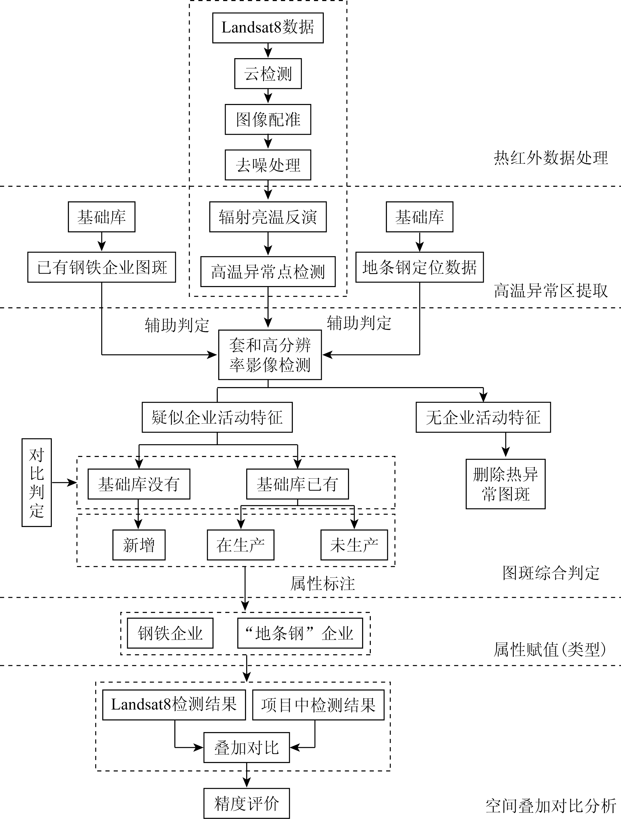
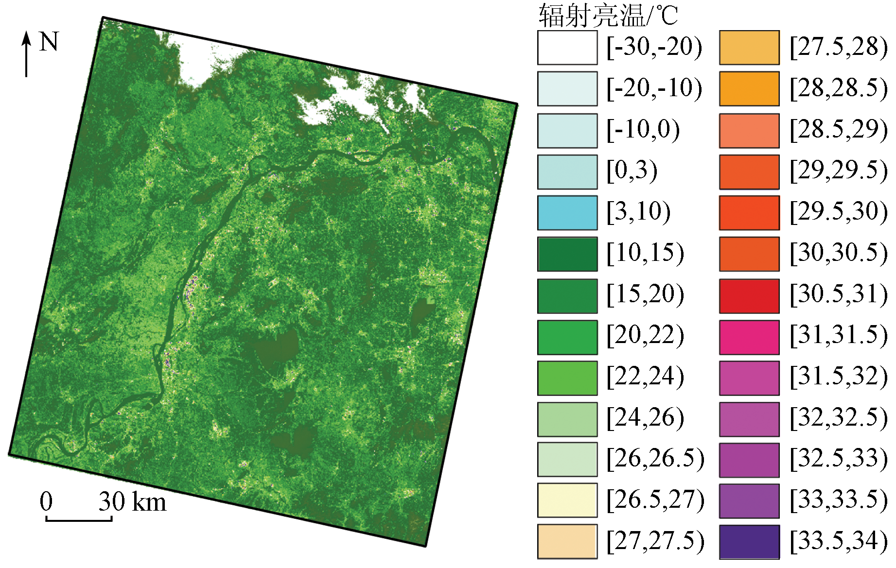
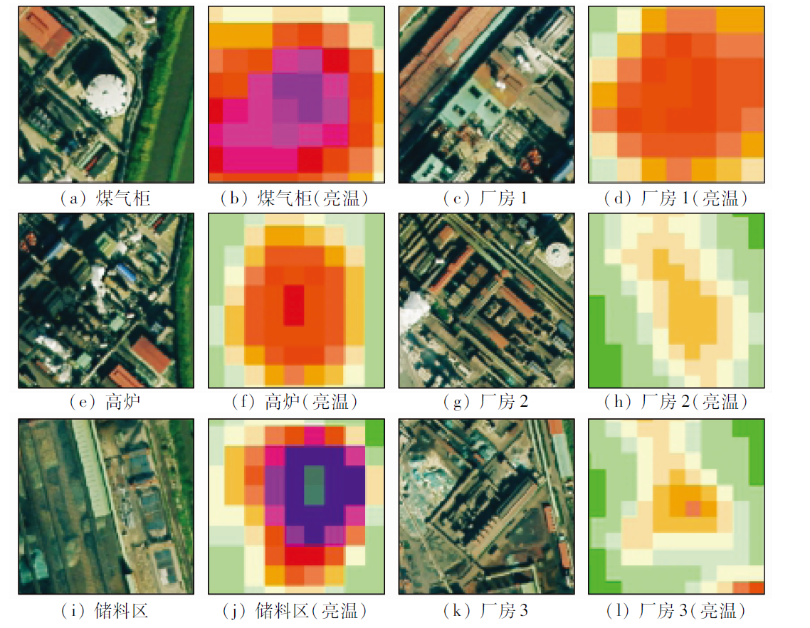
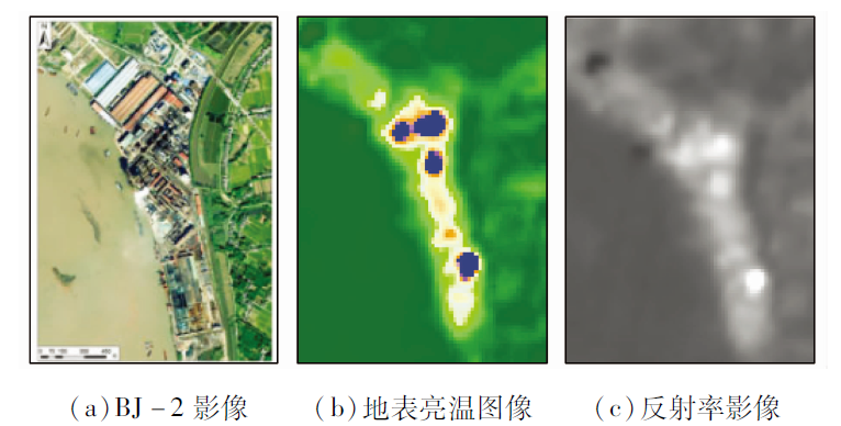
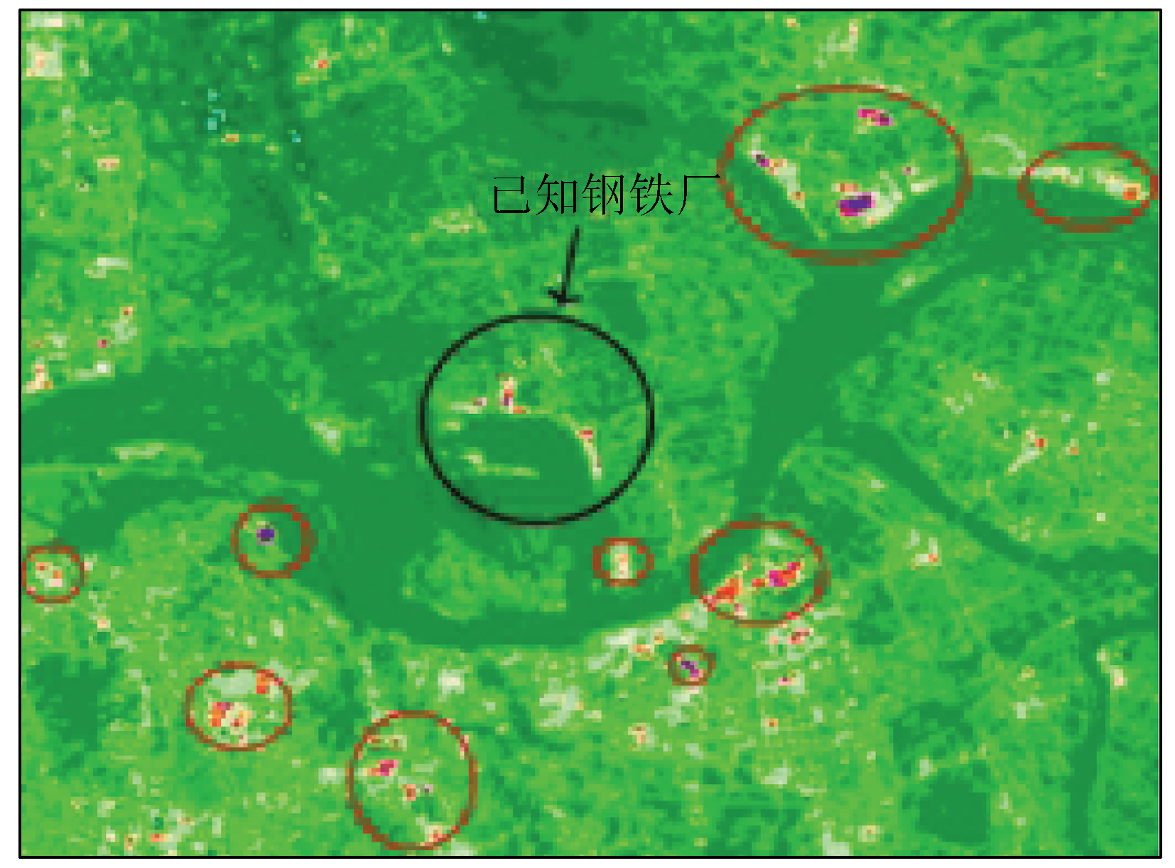
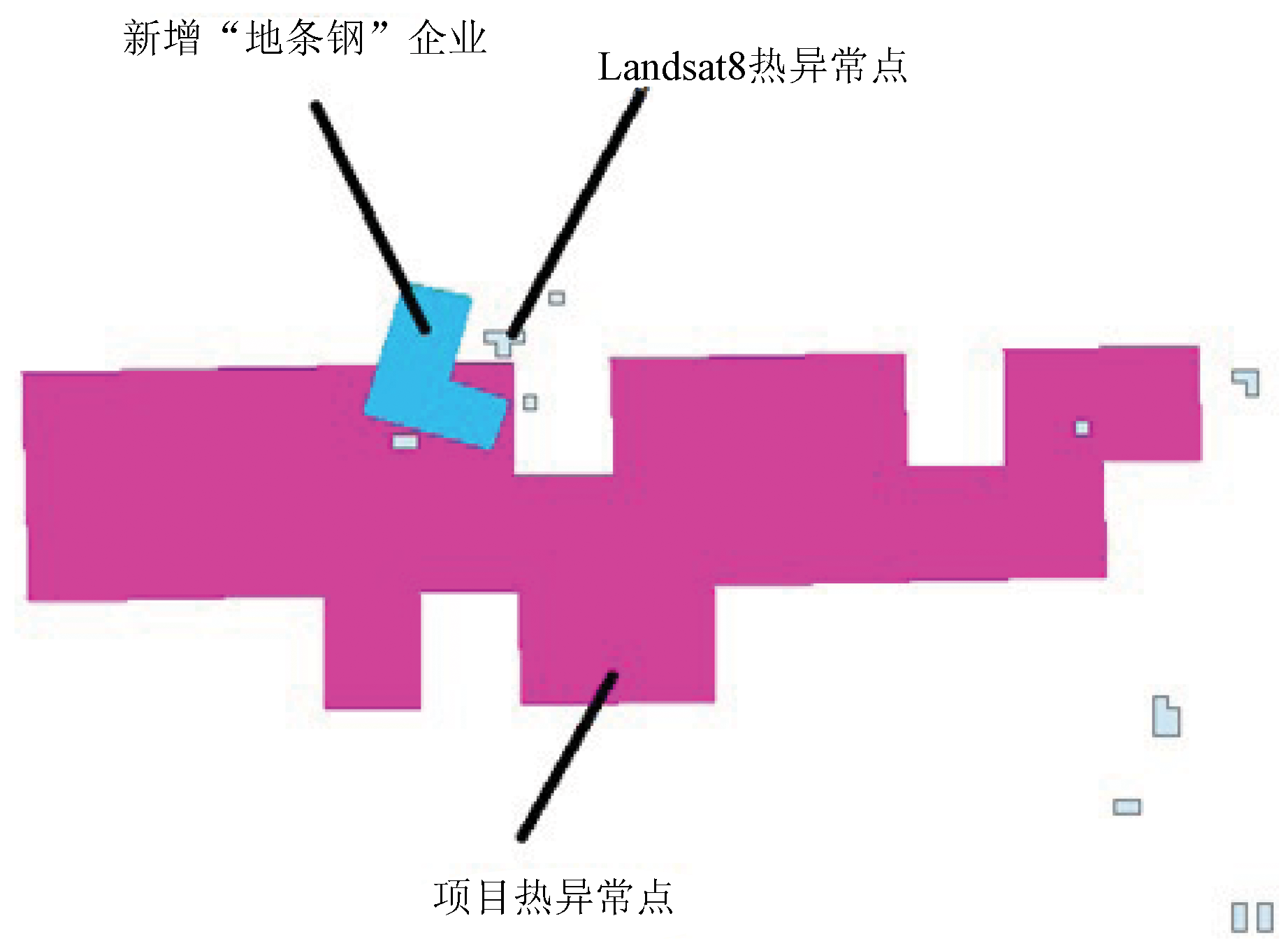
Abstract The monitoring of iron and steel enterprises through manual field supervision is time-consuming and labor-intensive. To address this problem, this study proposed identifying the high-temperature anomalous areas based on satellite-carried thermal infrared sensors. Then, based on conventional remote sensing interpretation combined with thermal infrared anomaly monitoring and the quasi-synchronous data of March to May in the first quarter, as well as the scope of existing iron and steel enterprises and high-resolution images of the same period, this study extracted information on suspected iron and steel enterprises/low-quality steel enterprises according to the thermal infrared threshold and the thermal anomaly distribution. Subsequently, interpretation symbols were constructed according to the medium- to high-resolution digital orthophoto maps (DOMs), and anomaly areas were identified by overlapping the map spots of existing iron and steel enterprises/low-quality steel enterprises. Finally, the monitoring results of the new method were tested using existing project results, forming the monitoring comparison results of steel overcapacity cutting. As a result, the comprehensive detection accuracy was 88.15%. The results of this study show that the Landsat8 data with a thermal infrared band of 10.6~11.19 μm can effectively monitor the high-temperature anomalies of iron and steel enterprises. Therefore, this band can be selected for future thermal anomaly monitoring based on thermal infrared remote sensing. This study is designed to explore more extensive data sources for monitoring steel overcapacity cutting and to provide approaches to solve the possible data bottlenecks and emergency monitoring problems. It can be used as a reference for guiding both project production and remote sensing monitoring of steel overcapacity cutting.
|
| Keywords
thermal infrared sensor
thermal infrared remote sensing
steel overcapacity cutting
thermal anomaly detection
|
|
|
|
Issue Date: 07 July 2023
|
|
|
| [1] |
张爱因, 张晓丽. Landsat8地表温度反演及其与MODIS温度产品的对比分析[J]. 北京林业大学学报, 2019, 41(3):1-13.
|
| [1] |
Zhang A Y, Zhang X L. Land surface temperature retrieved from Landsat8 and comparison with MODIS temperature product[J]. Journal of Beijing Forestry University, 2019, 41(3):1-13.
|
| [2] |
Synder W C, Wan Z, Zhang Y. Classification-based emissivity for land surface temperature measurement fromspace[J]. International Journal of Remote Sensing, 1998, 19(14):2753-2774.
doi: 10.1080/014311698214497
url: https://www.tandfonline.com/doi/full/10.1080/014311698214497
|
| [3] |
Li Z L, Tang B H, Wu H, et al. Satellite-derived land surface temperature:Current status and perspectives[J]. Remote Sensing of Environment, 2013, 131:14-37.
doi: 10.1016/j.rse.2012.12.008
url: https://linkinghub.elsevier.com/retrieve/pii/S0034425712004749
|
| [4] |
徐涵秋. 新型Landsat8卫星影像的反射率和地表温度反演[J]. 地球物理学报, 2015, 58(3):741-747.
|
| [4] |
Xu H Q. Retrieval of the reflectance and land surface temperature of the newly-launched Landsat8 satellite[J]. Chinese Journal of Geophysics, 2015, 58(3):741-747.
|
| [5] |
Qin Z, Karnieli A, Berliner P. A mono-window algorithmfor retrieving land surface temperature from Landsat TM data and its application to the Israel-Egypt border region[J]. International Journal of Remote Sensing, 2001, 22(18):3719-3746.
doi: 10.1080/01431160010006971
url: https://www.tandfonline.com/doi/full/10.1080/01431160010006971
|
| [6] |
张玉君. Landsat8简介[J]. 国土资源遥感, 2013, 25(1):176-177.
|
| [6] |
Zhang Y J. Landsat8 introduction[J]. Remote Sensing for Land and Resources, 2013, 25(1):176-177.
|
| [7] |
Schmugge T, Hook S J, Coll C. Recovering surface temperature and emissivity from thermal infrared multispectral data[J]. Remote Sensing of Environment, 1998, 65(2):121-131.
doi: 10.1016/S0034-4257(98)00023-6
url: https://linkinghub.elsevier.com/retrieve/pii/S0034425798000236
|
| [8] |
杨佩国, 胡俊锋, 刘睿. HJ-1B卫星热红外遥感影像农田地表温度反演[J]. 测绘科学, 2013, 181(1):60-62.
|
| [8] |
Yang P G, Hu J F, Liu R. Land surface temperature retrieval method in farmland area for HJ-1B IRS4[J]. Science of Surveying and Mapping, 2013, 181(1):60-62.
|
| [9] |
陈峰, 殷守敬, 朱利, 等. HJ-1B热红外辐射定标对地表温度反演的影响[J]. 遥感学报, 2016, 20(4):601-609.
|
| [9] |
Chen F, Yin S J, Zhu L, et al. Radiometric calibration of the HJ-1B thermal channel and its effects on land surface temperature retrieval[J]. National Remote Sensing Bulletin, 2016, 20(4):601-609.
|
| [10] |
朱亚静, 邢立新, 潘军, 等. 短波红外遥感高温地物目标识别方法研究[J]. 遥感信息, 2011(6):33-36.
|
| [10] |
Zhu Y J, Xing L X, Pan J, et al. Method of identifying high-temperature target using shortwave infrared remote sensing data[J]. Remote Sensing Information, 2011(6):33-36.
|
| [11] |
Van de Griend A A, Owe M. On the relationship between thermal emissivity and the normalized difference vegetation index for natural surfaces[J]. International Journal of Remote Sensing, 1993, 14(6):1119-1131.
doi: 10.1080/01431169308904400
url: https://www.tandfonline.com/doi/full/10.1080/01431169308904400
|
| [12] |
陈良富, 徐希孺. 热红外遥感中大气下行辐射效应的一种近似计算与误差估计[J]. 遥感学报, 1999, 3(3):165-l70.
|
| [12] |
Chen L F, Xu X R. An approximate numeration and error estimation on atmospheric downward radiance effectin thermal infrared remote sensing[J]. Journal of Remote Sensing, 1999, 3(3):165-l70.
|
| [13] |
陈鹏飞, 卢力, 朱华忠, 等. 不同分辨率遥感影像的钢铁厂识别适宜性研究[J]. 地球信息科学, 2015, 17(9):1119-1127.
|
| [13] |
Chen P F, Lu L, Zhu H Z, et al. Research on the suitability of image at different resolutions for the identification of steel enterprise using remote sensing[J]. Journal of Geo-Information Science, 2015, 17(9):1119-1127.
|
| [14] |
田国良, 柳钦火, 陈良富. 热红外遥感[M]. 北京: 电子工业出版社, 2014:5-13.
|
| [14] |
Tian G L, Liu Q H, Chen L F. Thermal remote sensing[M]. Beijing: Publishing House of Electronics Industry, 2014:5-13.
|
| [15] |
Andersen H S. Land surface temperature estimation based on NOAA-AVHRR data during the HAPEX-Sahel experiment[J]. Journal of Hydrology, 1997,188-189:788-814.
|
| [16] |
Prata A J, Caselles V, Coll C, et al. Thermal remote sensing of land surface temperature from satellites:Current status and future prospects[J]. Remote Sensing Reviews, 1995, 12(3):175-224.
doi: 10.1080/02757259509532285
url: http://www.tandfonline.com/doi/abs/10.1080/02757259509532285
|
| [17] |
李特雅, 宋妍, 于新莉, 等. 卫星热红外温度反演钢铁企业炼钢月产量估算模型[J]. 自然资源遥感, 2021, 33(4):121-129.doi:10.6046/zrzyyg.2020399.
doi: 10.6046/zrzyyg.2020399
|
| [17] |
Li T Y, Song Y, Yu X L, et al. Monthly production estimation model for steel companies based on inversion of satellite thermal infrared temperature[J]. Remote Sensing for Natural Resources, 2021, 33(4):121-129.doi:10.6046/zrzyyg.2020399.
doi: 10.6046/zrzyyg.2020399
|
|
Viewed |
|
|
|
Full text
|
|
|
|
|
Abstract
|
|
|
|
|
Cited |
|
|
|
|
| |
Shared |
|
|
|
|
| |
Discussed |
|
|
|
|
 2023,
Vol. 35
2023,
Vol. 35
 )
)