|
|
 |
|

|
|
|
A study of auxiliary monitoring in iron and steel plant based on multi-temporal thermal infrared remote sensing |
Jing LI1, Qiangqiang SUN1, Ping ZHANG1, Danfeng SUN1( ), Li WEN2, Xianwen LI2 ), Li WEN2, Xianwen LI2 |
1.College of Land Science and Technology, China Agricultural University, Beijing 100193, China
2.China Institute of Land Survey and Planning, Beijing 100035, China |
|
|
|
|
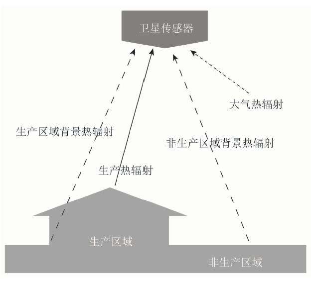
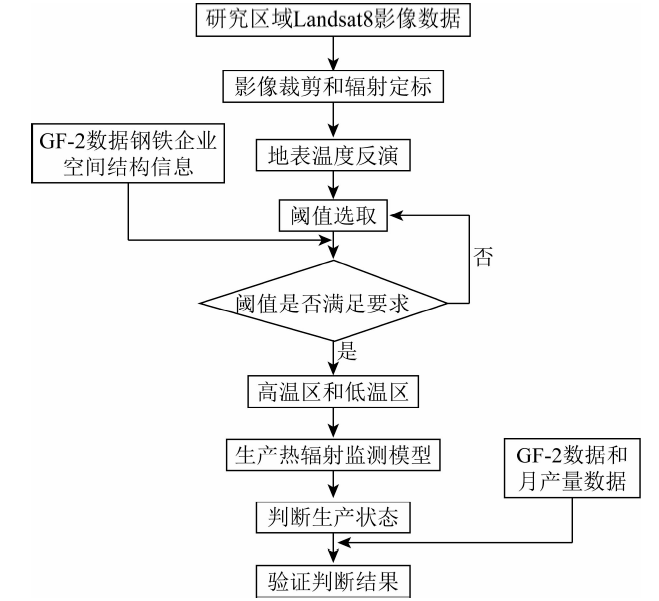
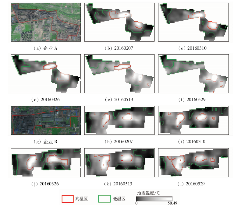
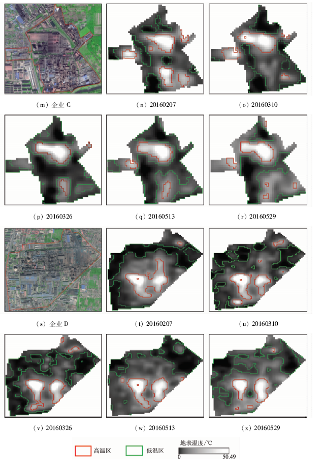
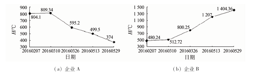
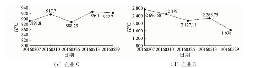
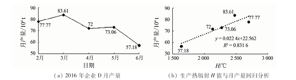
Abstract In order to monitor production state of iron and steel enterprises with auxiliary, the authors took Tangshan iron and steel enterprises as study cases to obtain the land surface temperature in tenth band of TIRS inversion derived from Landsat8 data on February 7, March 10, March 26, May 13 and May 29, 2016,in combination with the spatial structure of iron and steel enterprise information provided by GF-2 data from September 26, 2015 and September 10, 2016. The land surface temperature was finally divided into low temperature region (mainly non-production area) and high temperature region (mainly production area) by using threshold. On such a basis, the authors established production thermal radiation model to determine the production status of iron and steel enterprises in this period. Finally, the results obtained by the authors were preliminarily validated by the spatial structure change information provided by GF-2 satellite data and monthly output data of iron and steel enterprises. The results show that it is feasible to evaluate the production status of iron and steel enterprises by using thermal radiation model of production based on thermal infrared remote sensing.
|
| Keywords
thermal infrared remote sensing
Landsat8 TIRS
GF-2
iron and steel enterprises
monitoring
|
|
|
|
Corresponding Authors:
Danfeng SUN
E-mail: 1599799679@qq.com
|
|
Issue Date: 14 March 2019
|
|
|
| [1] |
黄导, 陈丽云, 张临峰 . 2015 年中国钢铁工业节能环保进展情况分析[J]. 中国钢铁业, 2016(7):14-18.
url: http://www.cqvip.com/QK/87072X/201707/672717195.html
|
| [1] |
Huang D, Chen L Y, Zhang L F . 2015 China steel industry energy saving and environmental protection progress analysis[J]. China steel industry, 2016(7):14-18.
|
| [2] |
勾艳辉 . 产能过剩所致失业人员再就业路径分析[D]. 大连:东北财经大学, 2016.
|
| [2] |
Gou Y H . Path Analysis of Reemployment of Unemployed People Caused by Excess Capacity[D]. Dalian:Dongbei University of Finance and Economics, 2016.
|
| [3] |
国务院发展研究中心"化解产能过剩长效机制"课题组, 周健奇 . 改革与发展:钢铁供给侧结构调整的两个关键[J]. 国家治理, 2016(20):41-48.
url: http://www.cnki.com.cn/Article/CJFDTotal-ZLGJ201620004.htm
|
| [3] |
The development research center of the State Council,"the long term mechanism for resolving excess production capacity", Zhou J Q . Reform and development:Two key aspects of structural adjustment of iron and steel supply side[J]. State Administration, 2016(20):41-48.
|
| [4] |
王金友 . 钢铁企业环境自动监测系统的设计与研究[D]. 上海:复旦大学, 2008.
|
| [4] |
Wang J Y . Design and Research of Automatic Environmental Monitoring System for Iron and Steel Enterprises[D]. Shanghai:Fudan University, 2008.
|
| [5] |
本刊 . 国家淘汰落后产能考核组来八钢检查落后产能淘汰情况[J]. 新疆钢铁, 2015(2):33-33.
url: http://www.cnki.com.cn/Article/CJFDTotal-XJGT201502011.htm
|
| [5] |
Benkan. Backward production capacity assessment team to check on the elimination of backward production capacity[J]. Xinjiang Iron and Steel Out of State, 2015(2):33-33.
|
| [6] |
张勇, 余涛, 顾行发 , 等. CBERS-02 IRMSS热红外数据地表温度反演及其在城市热岛效应定量化分析中的应用[J]. 遥感学报, 2006,10(5):789-797.
doi: 10.3321/j.issn:1007-4619.2006.05.028
url: http://d.wanfangdata.com.cn/Periodical/ygxb200605028
|
| [6] |
Zhang Y, Yu T, Gu X F , et al. Application of CBERS-02 IRMSS thermal infrared data to land surface temperature retrieval and its application in quantitative analysis of urban heat island effect[J]. Journal of Remote Sensing, 2006,10(5):789-797.
|
| [7] |
阚增辉, 刘朝顺, 李志军 . 基于Landsat-8热红外数据的太湖地区地表温度反演与热岛效应分析[J]. 华东师范大学学报(自然科学版), 2016(4):129-138.
doi: 10.3969/j.issn.1000-5641.2016.04.015
url: http://www.cnki.com.cn/Article/CJFDTotal-HDSZ201604015.htm
|
| [7] |
Kan Z H, Liu Z S, Li Z J . Retrieval of land surface temperature and analysis of heat island effect in Taihu based on Landsat-8 thermal infrared data[J]. Journal of East China Normal University (Natural Science Edttion), 2016(4):129-138.
|
| [8] |
Lo C P, Quattrochi D A, Luvall J C . Application of high-resolution thermal infrared remote sensing and GIS to assess the urban heat island effect[J]. International Journal of Remote Sensing, 1997,18(2):287-304.
doi: 10.1080/014311697219079
url: https://www.tandfonline.com/doi/full/10.1080/014311697219079
|
| [9] |
Han Q . Study on urban heat island effect with HJ-1B thermal infrared remote sensing image[J]. Spacecraft Recovery and Remote Sensing, 2012.
url: http://en.cnki.com.cn/Article_en/CJFDTOTAL-HFYG201201014.htm
|
| [10] |
蒲静娟, 董卫东, 关燕宁 , 等. 热红外遥感用于陡河水库生态环境研究[J]. 遥感学报, 1997,1(4):290-297.
doi: 10.1007/BF02951625
url: http://www.cnki.com.cn/Article/CJFDTotal-YGXB199704009.htm
|
| [10] |
Pu J J, Dong W D, Guan Y N , et al. Study on the ecological environment of Douhe Reservoir[J]. Journal of Remote Sensing, 1997,1(4):290-297.
|
| [11] |
吕月琳, 毛玉平, 史正涛 . 热红外遥感在地震监测预测中的应用[J]. 科技导报, 2009,27(6):91-96.
doi: 10.3321/j.issn:1000-7857.2009.06.018
url: http://www.cnki.com.cn/Article/CJFDTotal-KJDB200906036.htm
|
| [11] |
Lyu Y L, Mao Y P, Shi Z T . Thermal infrared remote sensing applied to earthquake monitoring and prediction.[J]. Science and Technology Review, 2009,27(6):91-96.
|
| [12] |
张戈, 詹方, 马惠 . 热红外遥感在森林消防工作中的应用简述[J]. 河南科技, 2014(13):182-182.
doi: 10.3969/j.issn.1003-5168.2014.13.134
url: http://www.cnki.com.cn/Article/CJFDTotal-HNKJ201413135.htm
|
| [12] |
Zhang G, Zhan F, Ma H . Application of thermal infrared remote sensing in forest fire prevention work[J]. Henan Science and Technology, 2014(13):182-182.
|
| [13] |
Kuenzer C, Dech S . Thermal infrared remote sensing:Sensors,methods,applications[J]. Photogrammetric Engineering and Remote Sensing, 2015,81(5):359-360.
doi: 10.1016/S0099-1112(15)30104-X
url: http://www.sciencedirect.com/science/article/pii/S009911121530104X
|
| [14] |
庞文正 . 红外热成像技术的最新发展以及在安防应用分析[J]. A&s:安全&自动化, 2010(12):144-146.
url: http://www.cqvip.com/QK/71135X/201107/36077444.html
|
| [14] |
Pang W Z . The latest development of infrared thermal imaging technology and security application analysis[J]. A&s:Security & Automation, 2010(12):144-146.
|
| [15] |
温少妍 . 地震构造区红外亮温背景场建立及异常提取方法研究[D]. 山东:中国石油大学, 2011.
|
| [15] |
Wen S Y . A study on the brightness temperature background field foundation and the method for extracting anomalies of thermal infrared in the seismotectonic area[D]. Shandong:China University of Petroleum, 2011.
|
| [16] |
徐涵秋, 黄绍霖 . Landsat 8 TIRS热红外光谱数据定标准确性的分析[J]. 光谱学与光谱分析, 2016,36(6):1941-1948.
url: http://www.opticsjournal.net/Articles/Abstract?aid=OJ161220000242x4A7D0
|
| [16] |
Xu H Q, Huang S L . Determination of the accuracy of Landsat 8 TIRS thermal infrared spectroscopy data[J]. Spectroscopy and Spectral Analysis, 2016,36(6):1941-1948.
|
| [17] |
杨学森 . 基于单通道算法的Landsat8卫星数据地表温度反演研究[D]. 北京:中国地质大学(北京), 2015.
|
| [17] |
Yang X S . Retrieval of Land Surface Temperature from Landsat8 Satellite Data Based on Single Channel Algorithm[D]. Beijing:China University of Geosciences(Beijing), 2015.
|
| [18] |
杨振胤, 张谷生, 王鑫 . 基于Landsat8遥感影像的土地利用分类研究——以陕西省西安市辖区为例[J]. 自然科学(文摘版), 2016(2):147-148.
url: http://www.cqvip.com/QK/71998x/201606/epub1000000214855.html
|
| [18] |
Yang Z Y, Zhang G S, Wang X . Land use classification based on Landsat8 remote sensing images:A case study of Xi’an City,Shaanxi Province[J]. Natural Science(Abstract), 2016(2):147-148.
|
| [19] |
Rozenstein O, Qin Z, Derimian Y , et al. Derivation of land surface temperature for Landsat-8 TIRS using a split window algorithm.[J]. Sensors, 2014,14(4):5768.
doi: 10.3390/s140405768
pmid: 4029672
url: http://www.mdpi.com/1424-8220/14/4/5768
|
| [20] |
Wang F, Qin Z, Song C , et al. An improved mono-window algorithm for land surface temperature retrieval from Landsat 8 thermal infrared sensor data[J]. Remote Sensing, 2015,7(4):4268-4289.
doi: 10.3390/rs70404268
url: http://www.mdpi.com/2072-4292/7/4/4268
|
| [21] |
李旭文, 牛志春, 姜晟 , 等. Landsat 8卫星OLI遥感影像在生态环境监测中的应用研究[J]. 环境监控与预警, 2013,5(6):1-5.
doi: 10.3969/j.issn.1674-6732.2013.06.001
url: http://www.cnki.com.cn/Article/CJFDTotal-HTJK201306002.htm
|
| [21] |
Li X W, Niu Z C, Jiang S , et al. Application of Landsat 8 satellite OLI remote sensing images in ecological environment monitoring[J]. Environmental Monitoring and Warning, 2013,5(6):1-5.
|
| [22] |
崔恩慧, 吴佳栋, 高剑 . 高分二号开启我国高分辨率遥感卫星应用时代[J]. 太空探索, 2014(10):6-9.
doi: 10.3969/j.issn.1009-6205.2014.10.004
url: http://www.cnki.com.cn/Article/CJFDTotal-TKTS201410014.htm
|
| [22] |
Cui E H, Wu J D, Gao J . High score two opens the era of high resolution remote sensing satellite applications in China[J]. Space Exploration, 2014(10):6-9.
|
| [23] |
梁树能, 魏红艳, 甘甫平 , 等. "高分二号"卫星数据在遥感地质调查中的初步应用评价[J]. 航天返回与遥感, 2015,36(4):63-72.
doi: 10.3969/j.issn.1009-8518.2015.04.009
url: http://www.cqvip.com/QK/91734X/201504/665902287.html
|
| [23] |
Liang S N, Wei H Y, Gan F P , et al. Preliminary application evaluation of high resolution two satellite data in remote sensing geological survey[J]. Space Flight Back and Remote Sensing, 2015,36(4):63-72.
|
| [24] |
刘肖姬, 梁树能, 吴小娟 , 等. "高分二号"卫星数据遥感滑坡灾害识别研究——以云南东川为例[J]. 航天返回与遥感, 2015,36(4):93-100.
doi: 10.3969/j.issn.1009-8518.2015.04.012
url: http://d.wanfangdata.com.cn/Periodical/htfhyyg201504012
|
| [24] |
Liu X J, Liang S N, Wu X J , et al. Identification of landslide hazard by remote sensing data of high resolution two satellite data:A case study of Yunnan,Dongchuan[J]. Space Flight Back and Remote Sensing, 2015,36(4):93-100.
|
| [25] |
吴小娟, 肖晨超, 崔振营 , 等. "高分二号"卫星数据面向对象的海岸线提取法[J]. 航天返回与遥感, 2015,36(4):84-92.
doi: 10.3969/j.issn.1009-8518.2015.04.011
url: http://www.cqvip.com/QK/91734X/201504/665902290.html
|
| [25] |
Wu X J, Xiao C C, Cui Z Y , et al. "High vibration camp,No.two"coast satellite data object extraction method returns[J]. Space and Remote Sensing, 2015,36(4):84-92.
|
| [26] |
Li Z L, Tang B H, Wu H , et al. Satellite-derived land surface temperature:Current status and perspectives[J]. Remote Sensing of Environment, 2013,131(131):14-37.
doi: 10.1016/j.rse.2012.12.008
url: https://linkinghub.elsevier.com/retrieve/pii/S0034425712004749
|
| [27] |
覃志豪 . 用陆地卫星TM6数据演算地表温度的单窗算法[J]. 地理学报, 2001,56(4):456-466.
doi: 10.1142/S0252959901000401
url: http://d.wanfangdata.com.cn/Periodical/dlxb200104009
|
| [27] |
Qin Z H . Single window algorithm for using terrestrial satellite TM6 data to calculate surface temperature[J]. Geographica Sinica, 2001,56(4):456-466
|
| [28] |
宋挺, 段峥, 刘军志 , 等. Landsat 8数据地表温度反演算法对比[J]. 遥感学报, 2015,19(3):451-464.
doi: 10.11834/jrs.20154180
url: http://d.wanfangdata.com.cn/Periodical/ygxb201503009
|
| [28] |
Song T, Duan Z, Liu J Z , et al. Landsat 8 surface temperature inversion algorithm comparison data[J]. Journal of Remote Sensing, 2015,19(3):451-464.
|
| [29] |
Krofcheck D, Eitel J, Lippitt C , et al. Remote sensing based simple models of GPP in both disturbed and undisturbed piñon-juniper woodlands in the southwestern U.S.[J]. Remote Sensing, 2015,8(1):20.
doi: 10.3390/rs8010020
url: http://www.mdpi.com/2072-4292/8/1/20
|
| [30] |
闫丽莉, 屈春燕, 温少妍 , 等. 卫星热红外亮温、气温及地温观测的年变变化对比研究[J]. 地震学报, 2012,34(2):257-266.
doi: 10.3969/j.issn.0253-3782.2012.02.012
url: http://d.wanfangdata.com.cn/Periodical_dizhen201202012.aspx
|
| [30] |
Yan L L, Qu C Y, Wen S Y , et al. A comparison study on annual variation of thermal infrared brigtness temperature from meteorological stations[J]. Acta Seismologica Sinica, 2012,34(2):257-266.
|
| [31] |
Barsi J, Schott J, Hook S , et al. Landsat-8 thermal infrared sensor (TIRS) vicarious radiometric calibration[J]. Remote Sensing, 2014,6(11):11607-11626.
doi: 10.3390/rs61111607
url: http://www.mdpi.com/2072-4292/6/11/11607
|
| [32] |
高文升, 张雨泽, 房世峰 , 等. 基于Landsat-8 TIRS的大气参数快速估算方法[J]. 地球信息科学学报, 2017,19(1):110-116.
doi: 10.3724/SP.J.1047.2017.00110
url: http://d.wanfangdata.com.cn/Periodical/dqxxkx201701013
|
| [32] |
Gao W S, Zhang Y Z, Fang S F , et al. A fast estimation method of atmospheric parameters for Landsat-8 TIRS data[J]. Journal of Geo-information Science, 2017,19(1):110-116.
|
| [33] |
Nikam B R, Ibragimov F, Chouksey A , et al. Retrieval of land surface temperature from Landsat 8 TIRS for the command area of Mula irrigation project[J]. Environmental Earth Sciences, 2016,75(16):1169.
doi: 10.1007/s12665-016-5952-3
url: http://link.springer.com/10.1007/s12665-016-5952-3
|
| [34] |
徐涵秋 . 新型Landsat8卫星影像的反射率和地表温度反演[J]. 地球物理学报, 2015,58(3):741-747.
doi: 10.6038/cjg20150304
|
| [34] |
Xu H Q . Retrieval of reflectance and land surface temperature of the newly-launched Landsat8 satellite[J]. Journal of Geophysics, 2015,58(3):741-747.
|
| [35] |
Nichol G, Thomas E, Callaway C W , et al. Regional variation in out-of-hospital cardiac arrest incidence and outcome[J]. JAMA. 2008,300(12):1423-1431.
doi: 10.1001/jama.300.12.1423
url: http://jama.jamanetwork.com/article.aspx?doi=10.1001/jama.300.12.1423
|
| [36] |
许冰, 牛燕雄, 邓春雨 , 等. 基于图像频谱全局均值标准差分割的点扩散函数估计[J]. 光学技术, 2015,41(4):341-345.
url: http://www.opticsjournal.net/Articles/Abstract?aid=OJ160119000509dJgMjP
|
| [36] |
Xu B, Niu Y X, Deng C Y , et al. Algorithm of global mean and standard deviation for motion blur parameters identification[J]. Optical Technique, 2015,41(4):341-345.
|
| [37] |
王国定 . 平均数指数和平均指标指数的比较[J]. 中国统计, 1998(8):29-30.
url: http://www.cnki.com.cn/Article/CJFDTotal-ZGTJ808.014.htm
|
| [37] |
Wang G D . Comparison of mean index and average index index[J]. China Statistics, 1998(8):29-30.
|
|
Viewed |
|
|
|
Full text
|
|
|
|
|
Abstract
|
|
|
|
|
Cited |
|
|
|
|
| |
Shared |
|
|
|
|
| |
Discussed |
|
|
|
|
 2019,
Vol. 31
2019,
Vol. 31