|
|
|
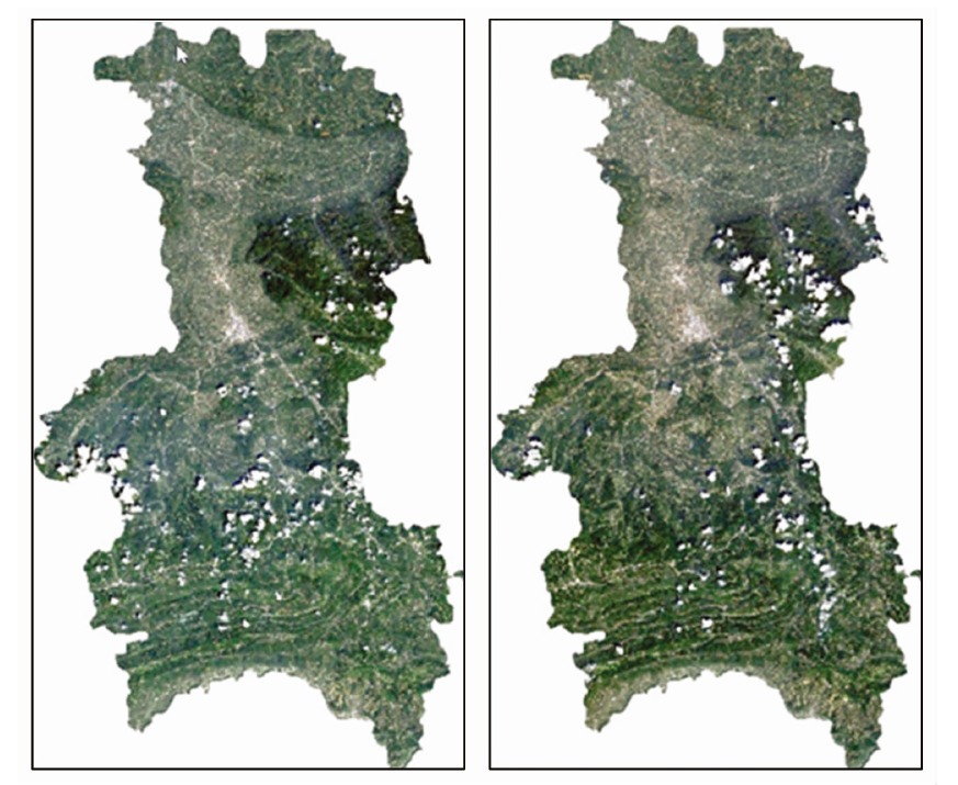
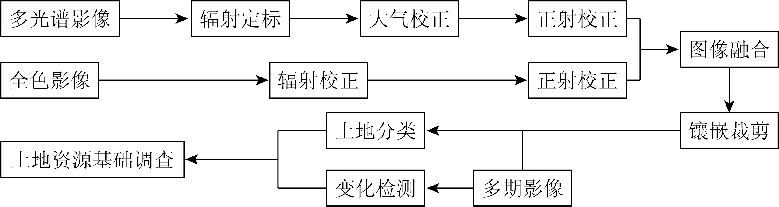
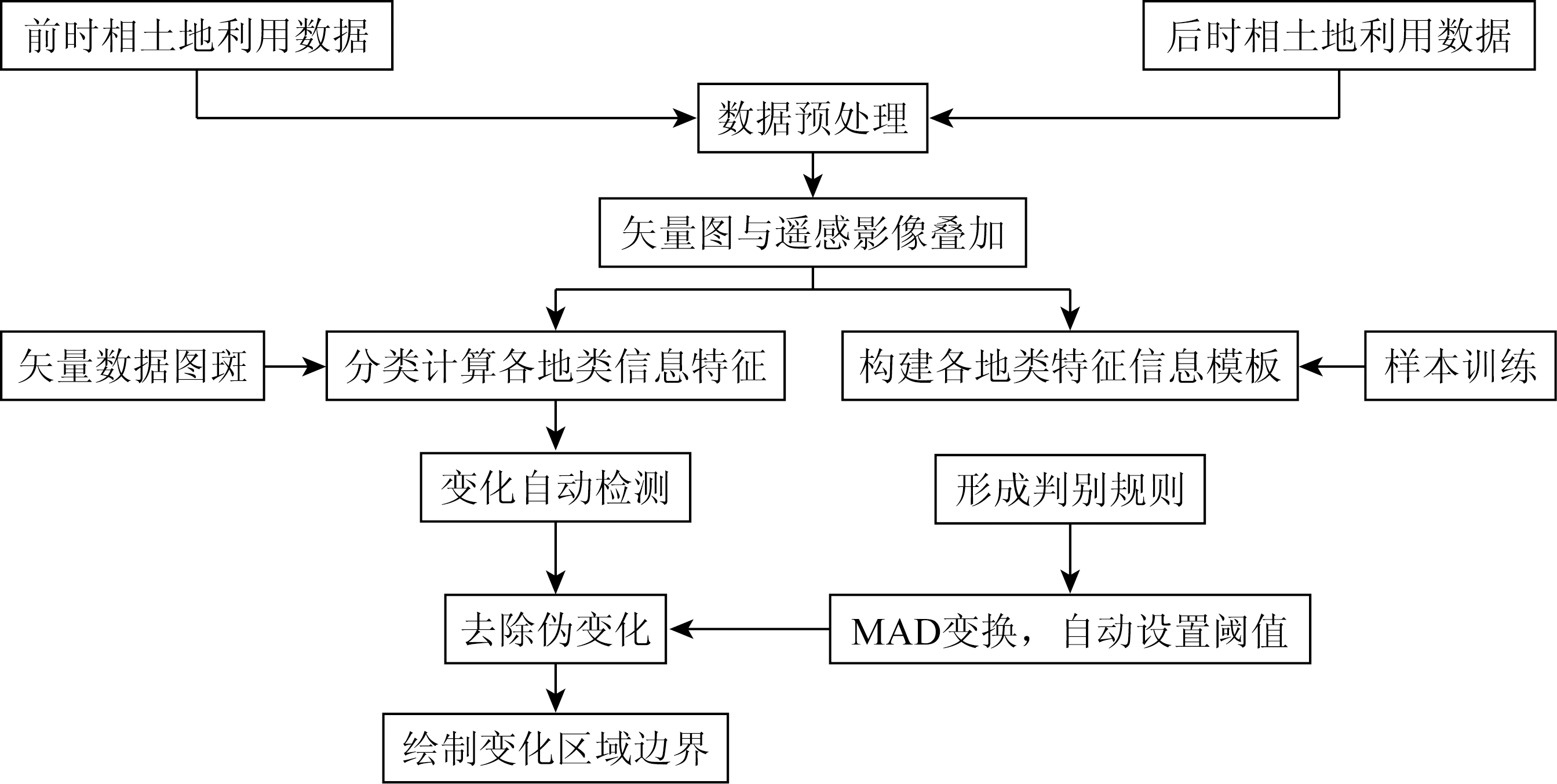
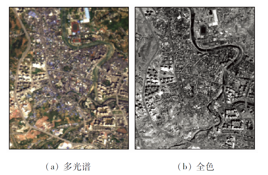
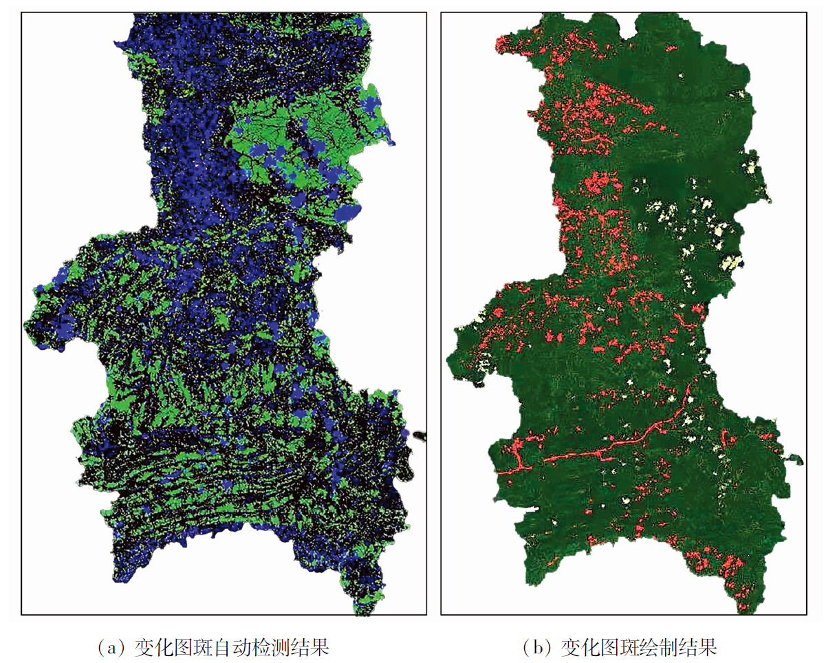
Abstract The survey and change monitoring of natural resources can provide an important guarantee for the implementation of systematic policies, protection, and rational utilization of resources and are of great significance for the building of the national land space planning system, the reform of the resource management system, the modernization of space governance capacity, and the construction of national ecological civilization. Western China is characterized by a vast area, insufficient basic land data, and unreliable land change monitoring. Therefore, there is an urgent need to provide efficient and accurate survey results at a low cost for such a large area. Based on the domestic high-resolution satellite (GF-6) images and the results of the third national land survey, this study carried out a demonstration of the application of the intelligent rural land survey to the areas subject to rapid development in western China in Xuyong County. To this end, remote sensing images with high spatial resolution and hyperspectral resolution were obtained through panchromatic and multispectral image fusion. Then, the fused data were used for the basic survey of land resources in Xuyong County. Subsequently, based on the object-oriented image classification and the results of the third national land survey, supervised classification of the remote sensing images was conducted, and areas with changes in land were automatically extracted, thus forming a new efficient land survey model for the areas subject to rapid development in western China. The survey results can provide strong support in terms of basic land information for the rapid development of specialty industries in western China and have a certain value in popularization and applications.
|
| Keywords
GF-6
natural resource survey
supervised classification
change monitoring
|
|
|
|
Issue Date: 07 July 2023
|
|
|
| [1] |
张颢骞. 高分遥感影像在第三次全国国土调查中的应用价值分析[J]. 建材与装饰, 2019(32):241-242.
|
| [1] |
Zhang H Q. Application value analysis of high resolution remote sensing images in the third national land survey[J]. Construction Materials & Decoration, 2019(32):241-242.
|
| [2] |
首颗农业高分观测卫星成功发射[J]. 农业科技与信息, 2018(18):72.
|
| [2] |
The first agricultural high resolution observation satellite was successfully launched[J]. Agricultural Science-Technology and Information, 2018(18):72.
|
| [3] |
袁新悦, 甘淑, 袁希平. 基于高分2号遥感影像的监督分类方法探讨——以东川区小江的河谷地带为例[J]. 地质灾害与环境保护, 2021, 32(2):78-81.
|
| [3] |
Yuan X Y, Gan S, Yuan X P. Discussion on supervised classification method ased on GF-2 satellite data:The valley of Xiaojiang River in Chuandong District[J]. Journal of Geological Hazards and Environment Preservation, 2021, 32(2):78-81.
|
| [4] |
王译著, 黄亮, 陈朋弟, 等. 联合显著性和多方法差异影像融合的遥感影像变化检测[J]. 自然资源遥感, 2021, 33(3):89-96.doi:10.6046/zrzyyg.2020312.
doi: 10.6046/zrzyyg.2020312
|
| [4] |
Wang Y Z, Huang L, Chen P D, et al. Change detection of remote sensing images based on the fusion of co-saliency difference images[J]. Remote Sensing for Natural Resources, 2021, 33(3):89-96.doi:10.6046/zrzyyg.2020312.
doi: 10.6046/zrzyyg.2020312
|
| [5] |
王跃峰, 武慧智, 何姝珺, 等. 河南省信阳市浉河区自然资源智能化信息提取技术方法研究[J]. 国土资源遥感, 2020, 32(4):244-250.doi:10.6046/gtzyyg.2020.04.30.
doi: 10.6046/gtzyyg.2020.04.30
|
| [5] |
Wang Y F, Wu H Z, He S J, et al. Method research of intelligentized extraction of natural resources information from Shihe District,Xinyang City,Henan Province[J]. Remote Sensing for Land and Resources, 2020, 32(4):244-250.doi:10.6046/gtzyyg.2020.04.30
doi: 10.6046/gtzyyg.2020.04.30
|
| [6] |
方梦阳, 刘晓煌, 孔凡全, 等. 一种基于GEE平台制作逐年土地覆盖数据的方法——以黄河流域为例[J]. 自然资源遥感, 2022, 34(1):135-141.doi:10.6046/zrzyyg.2021088.
doi: 10.6046/zrzyyg.2021088
|
| [6] |
Fang M Y, Liu X H, Kong F Q, et al. A method for creating annual land cover data based on Google Earth Engine:A case study of the Yellow River basin[J]. Remote Sensing for Natural Resources, 2022, 34(1):135-141.doi:10.6046/zrzyyg.2021088.
doi: 10.6046/zrzyyg.2021088
|
| [7] |
唐大珍, 于礼. 泸州市土地利用动态变化研究[J]. 农村经济与科技, 2011, 22(1):19-22.
|
| [7] |
Tang D Z, Yu L. Study on dynamic change of land use in Luzhou City[J]. Rural Economy and Science-Technology, 2011, 22(1):19-22.
|
| [8] |
唐侨, 陈涛, 刘思源, 等. 基于3S 技术的土地利用信息动态变更调查新机制研究——以成都市为例[J]. 测绘与空间地理信息, 2015(1):77-80.
|
| [8] |
Tang Q, Chen T, Liu S Y, et al. The research on new mechanism about dynamically changing of land use information based on 3S technology: Take Chengdu for example[J]. Geomatics & Spatial Information Technology, 2015(1):77-80.
|
| [9] |
Matthew M W, Adler-Golden S M, Berk A, et al. Atmosphere-ic correction of spectral imagery:Evaluation of the FLAASH algorithm with AVIRIS data[J]. Applied Imagery Patten Recognition Workshop, 2002(31):157-163.
|
| [10] |
王志伟, 杨国东, 张旭晴, 等. 高分六号卫星遥感影像不同几何校正方法精度对比研究[J]. 世界地质, 2021, 40(1):125-130,139.
|
| [10] |
Wang Z W, Yang G D, Zhang X Q, et al. A comparative research on the accuracty of different geometric correction methods of Gaofen-6 satellite remote sensing image[J]. Global Geology, 2021, 40(1):125-130,139.
|
| [11] |
Sun W, Chen B, Messinger D W. Nearest-neighbor diffusion-based pan-sharpening algorithm for spectral images[J]. Optical Engineering, 2014, 53(1):013107.
doi: 10.1117/1.OE.53.1.013107
url: http://opticalengineering.spiedigitallibrary.org/article.aspx?doi=10.1117/1.OE.53.1.013107
|
| [12] |
尤淑撑, 张锐, 董丽娜, 等. 自然资源卫星遥感常态化监测框架设计及关键技术[J]. 地理信息世界, 2020, 27(5):115-120,128.
|
| [12] |
You S C, Zhang R, Dong L N, et al. Framework and key technologies for natural resources satellites remote sensing monitoring[J]. Geomatics World, 2020, 27(5):115-120,128.
|
| [13] |
窦世卿, 宋莹莹, 徐勇, 等. 基于随机森林的高分影像分类及土地利用变化检测[J]. 无线电工程, 2021, 51(9):901-908.
|
| [13] |
Dou S Q, Song Y Y, Xu Y, et al. High resolution image classification and land use change detection based on random forest[J]. Radio Engineering, 2021, 51(9):901-908.
|
| [14] |
滕玲玲, 吴武, 廖玉斌. 基于分类变化检测方法的地表覆盖影像特征数据更新处理研究[J]. 测绘与空间地理信息, 2020, 43(11):159-161,165.
|
| [14] |
Teng L L, Wu W, Liao Y B. Research on updating process of land cover image feature data based on classification change detection method[J]. Geomatics & Spatial Information Technology, 2020, 43(11):159-161,165.
|
| [15] |
Castellana L, D’Addabbo A, Pasquariello G. A composed super-vised / unsupervised approach to improve change detection from remote sensing[J]. Pattern Recognition Letters, 2007, 28(4) :405-413.
doi: 10.1016/j.patrec.2006.08.010
url: https://linkinghub.elsevier.com/retrieve/pii/S0167865506002200
|
| [16] |
Csaba B A, Maha S, Zoltan K, et al. Multilayer Markov random field models for change detection in optical remote sensing images[J]. ISPRS Journal of Photogrammetry and Remote Sensing, 2015, 107(9):22-37.
doi: 10.1016/j.isprsjprs.2015.02.006
url: https://linkinghub.elsevier.com/retrieve/pii/S0924271615000416
|
| [17] |
Qian Z, Xin H, Zhang L. An energy-driven total variation model for segmentation and classification of high spatial resolution remote-sensing imagery[J]. IEEE Geoscience & Remote Sensing Letters, 2013, 10(1):125-129.
|
| [18] |
Felzenszwalb P F, Huttenlocher D P. Efficient belief propagation for early vision[J]. International Journal of Computer Vision, 2006, 70(1):41-54.
doi: 10.1007/s11263-006-7899-4
url: http://link.springer.com/10.1007/s11263-006-7899-4
|
| [19] |
Kropatsch W G, Haxhimusa Y. Grouping and segmentation in a hierarchy of graphs[C]// Computational Imaging Ⅱ Proceeding of SPIE, 2004.
|
| [20] |
Nielsen A A. The regularized iteratively reweighted MAD method for change detection in multi -and hyperspectral data[J]. IEEE Transactions on Image Processing:A Publication of the IEEE Signal Processing Society, 2007, 16(2) :463-478.
doi: 10.1109/TIP.2006.888195
url: http://ieeexplore.ieee.org/document/4060945/
|
| [21] |
赵展, 夏旺, 闫利. 基于多源数据的土地利用变化检测[J]. 国土资源遥感, 2018, 30(4):148-155.doi:10.6046/gtzyyg.2018.04.22.
doi: 10.6046/gtzyyg.2018.04.22
|
| [21] |
Zhao Z, Xia W, Yan L. Land use change detection based on multi-source data[J]. Remote Sensing for Land and Resources, 2018, 30(4):148-155.doi:10.6046/gtzyyg.2018.04.22.
doi: 10.6046/gtzyyg.2018.04.22
|
|
Viewed |
|
|
|
Full text
|
|
|
|
|
Abstract
|
|
|
|
|
Cited |
|
|
|
|
| |
Shared |
|
|
|
|
| |
Discussed |
|
|
|
|
 2023,
Vol. 35
2023,
Vol. 35
 ), ZHANG Yi(