|
|
 |
|

|
|
|
Estimating latent heat flux over farmland from Landsat images using the improved METRIC model |
Jian YU1, Yunjun YAO1( ), Shaohua ZHAO2, Kun JIA1, Xiaotong ZHANG1, Xiang ZHAO1, Liang SUN3 ), Shaohua ZHAO2, Kun JIA1, Xiaotong ZHANG1, Xiang ZHAO1, Liang SUN3 |
1. State Key Laboratory of Remote Sensing Science, College of Remote Sensing Science and Engineering, Beijing Normal University, Beijing 100875, China
2. Satellite Environment Center, Ministry of Environmental Protection, Beijing 100094, China
3. USDA-ARS Hydrology and Remote Sensing Laboratory, Beltsville MD20705, USA |
|
|
|
|
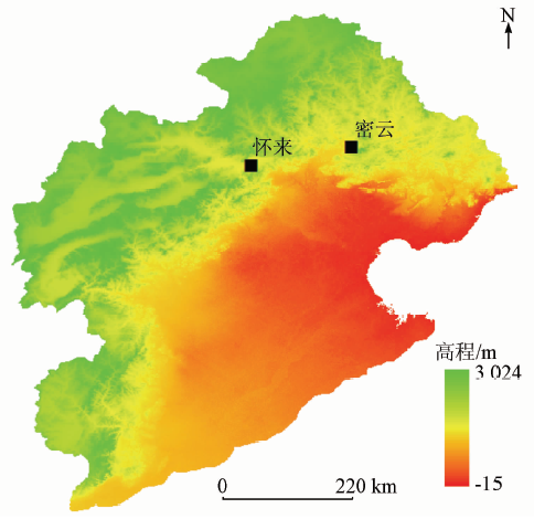
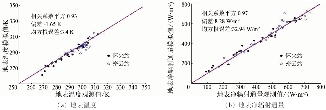
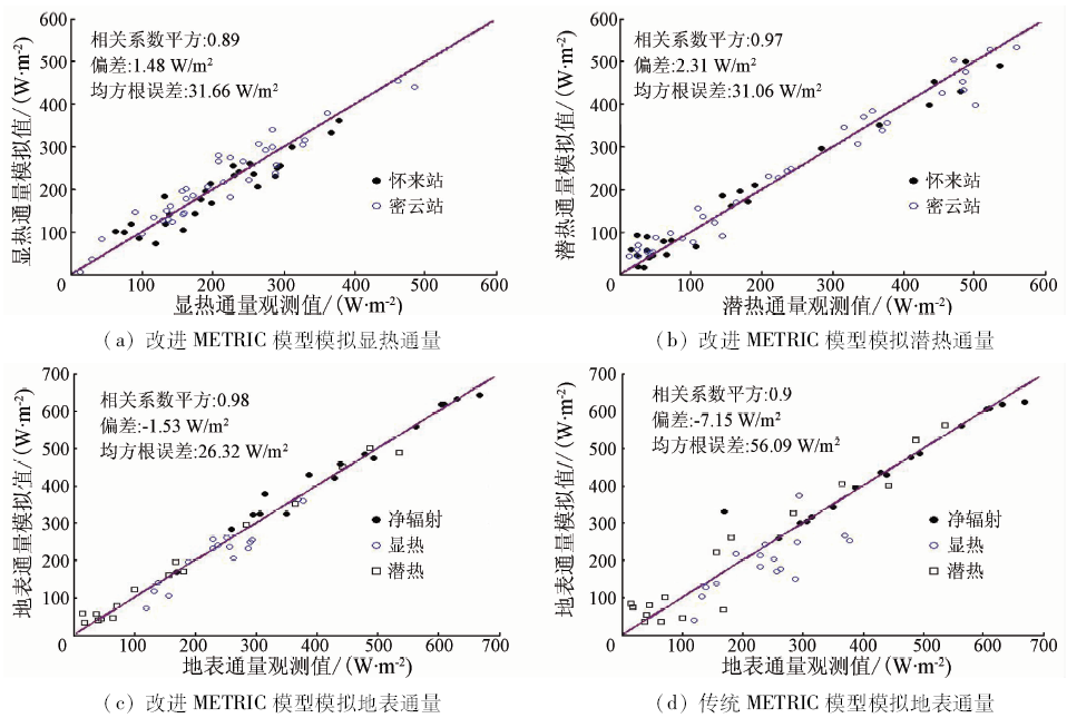
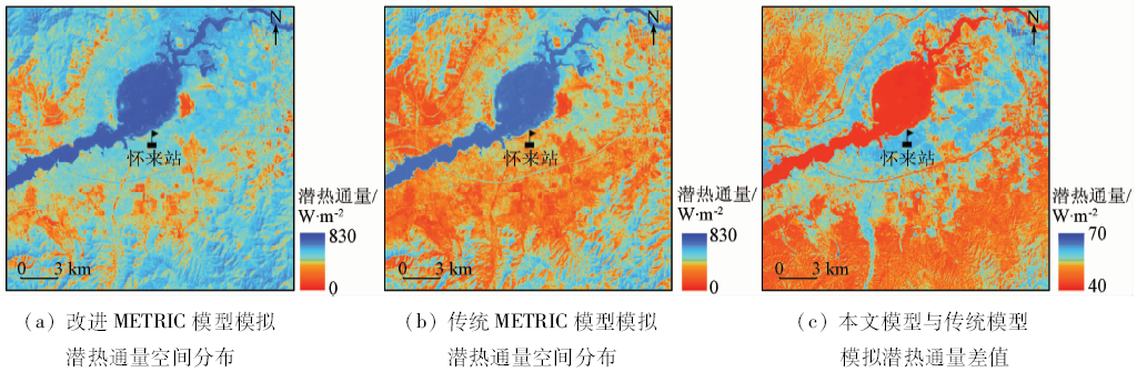
Abstract Estimation of latent heat flux based on thermal infrared remote sensing is of great significance in agricultural drought and water resources management. This paper examined the applicability of using METRIC model to estimate latent heat flux over farmland from Landsat images. Land surface temperature (Ts) required for estimation of the flux was computed from Landsat thermal infrared data by the mono-window algorithm. Meanwhile, an improved METRIC algorithm based on surface roughness was proposed to estimate the latent heat flux of farmland by improving the surface roughness parameters. The result of the algorithm was verified by the flux observation data from two observation stations of Huailai and Miyun in the Haihe River basin. The results show that the square of correlation coefficient (R 2) between simulated and observed values is 0.97, which is better than the conventional METRIC model (R 2 = 0.89). The improved algorithm has higher estimation accuracy of latent heat flux. In addition, the spatial distribution of latent heat flux also shows that the spatial pattern of the improved model is more reasonable. However, due to the limitation of data acquisition, only two stations in Beijing have been used to validate the algorithm, and hence further verification in other areas is needed.
|
| Keywords
farmland latent heat flux
thermal infrared remote sensing
METRIC
land surface temperature
|
|
|
|
Corresponding Authors:
Yunjun YAO
E-mail: boyyunjun@163.com
|
|
Issue Date: 10 September 2018
|
|
|
| [1] |
姚云军, 程洁, 赵少华 , 等. 基于热红外遥感的农田蒸散估算方法研究综述[J]. 地球科学进展, 2012,27(12):1308-1318.
doi: 10.11867/j.issn.1001-8166.2012.12.1308
url: http://d.wanfangdata.com.cn/Periodical/dqkxjz201212002
|
| [1] |
Yao Y J, Cheng J, Zhao S H , et al. Estimation of farmland evapotranspiration:A review of methods using thermal infrared remote sensing data[J]. Advances in Earth Science, 2012,27(12):1308-1318.
|
| [2] |
周倜, 彭志晴, 辛晓洲 , 等. 非均匀地表蒸散遥感研究综述[J]. 遥感学报, 2016,20(2):257-277.
doi: 10.11834/jrs.20165030
url: http://d.wanfangdata.com.cn/Periodical_ygxb201602009.aspx
|
| [2] |
Zhou T, Peng Z Q, Xin X Z , et al. Remote sensing research of evapotranspiration over heterogeneous surfaces:A review[J]. Journal of Remote Sensing, 2016,20(2):257-277.
|
| [3] |
Brown K W, Rosenberg N J . A resistance model to predict evapotranspiration and its application to a sugar beet field[J]. Agronomy Journal, 1973,65(3):341-347.
doi: 10.2134/agronj1973.00021962006500030001x
url: https://www.agronomy.org/publications/aj/abstracts/65/3/AJ0650030341
|
| [4] |
Seguin B, Itier B . Using midday surface temperature to estimate daily evaporation from satellite thermal IR data[J]. International Journal of Remote Sensing, 1983,4(2):371-383.
doi: 10.1080/01431168308948554
url: http://www.tandfonline.com/doi/abs/10.1080/01431168308948554
|
| [5] |
Shuttleworth W J, Wallace J S . Evaporation from sparse crops-an energy combination theory[J]. Quarterly Journal of the Royal Meteorological Society, 1985,111(469):839-855.
doi: 10.1002/qj.49711146910
url: http://doi.wiley.com/10.1002/qj.49711146910
|
| [6] |
Shuttleworth W J . Evaporation Models in Hydrology[M]. New York:Springer, 1991: 93-120.
|
| [7] |
Bastiaanssen W G M, Pelgrum H, Wang J, et al.A remote sensing surface energy balance algorithm for land( SEBAL) .:Part 2:Validation[J].Journal of Hydrology, 1998, 212-213:213-229.
doi: 10.1016/S0022-1694(98)00254-6
url: http://linkinghub.elsevier.com/retrieve/pii/S0022169498002546
|
| [8] |
Bastiaanssen W G M . SEBAL-based sensible and latent heat fluxes in the irrigated Gediz Basin,Turkey[J]. Journal of Hydrology, 2000,229(1/2):87-100.
doi: 10.1016/S0022-1694(99)00202-4
url: http://linkinghub.elsevier.com/retrieve/pii/S0022169499002024
|
| [9] |
Allen R G, Tasumi M, Trezza R . Satellite-based energy balance for mapping evapotranspiration with internalized calibration(METRIC)-model[J]. Journal of Irrigation and Drainage Engineering, 2007,133(4):380-394.
doi: 10.1061/(ASCE)0733-9437(2007)133:4(380)
url: http://ascelibrary.org/doi/10.1061/%28ASCE%290733-9437%282007%29133%3A4%28380%29
|
| [10] |
Allen R, Irmak A, Trezza R , et al. Satellite-based ET estimation in agriculture using SEBAL and METRIC[J]. Hydrological Processes, 2011,25(26):4011-4027.
doi: 10.1002/hyp.8408
url: http://doi.wiley.com/10.1002/hyp.8408
|
| [11] |
何磊, 王瑶, 别强 , 等. 基于SEBS-METRIC方法的黑河流域中游地区农田蒸散[J]. 兰州大学学报(自然科学版), 2013,49(4):504-510.
|
| [11] |
He L, Wang Y, Bie Q , et al. Estimation of field evapotranspiration in the middle reaches of Heihe River basin based on SEBS-METRIC method[J]. Journal of Lanzhou University(Natural Sciences), 2013,49(4):504-510.
|
| [12] |
连晋姣, 黄明斌, 李杏鲜 , 等. 夏季黑河中游绿洲样带蒸散量遥感估算[J]. 农业工程学报, 2014,30(15):120-129.
doi: 10.3969/j.issn.1002-6819.2014.15.017
url: http://d.wanfangdata.com.cn/Periodical/nygcxb201415017
|
| [12] |
Lian J J, Huang M B, Li X X , et al. Evapotranspiration estimation for oasis transect in middle reach of Heihe river basin based on remote sensing[J]. Transactions of the Chinese Society of Agricultural Engineering, 2014,30(15):120-129.
|
| [13] |
曹永强, 张亭亭, 徐丹 , 等. 海河流域蒸散发时空演变规律分析[J]. 资源科学, 2014,36(7):1489-1500.
|
| [13] |
Cao Y Q, Zhang T T, Xu D , et al. Analysis of evapotranspiration of temporal-space evolution in the Haihe basin[J]. Resources Science, 2014,36(7):1489-1500.
|
| [14] |
刘小莽, 郑红星, 刘昌明 , 等. 海河流域潜在蒸散发的气候敏感性分析[J]. 资源科学, 2009,31(9):1470-1476.
|
| [14] |
Liu X M, Zheng H X, Liu C M , et al. Sensitivity of the potential evapotranspiration to key climatic variables in the Haihe River basin[J]. Resources Science, 2009,31(9):1470-1476.
|
| [15] |
覃志豪, Zhang M H, Karnieli A, 等. 用陆地卫星TM6数据演算地表温度的单窗算法[J]. 地理学报, 2001,56(4):456-466.
|
| [15] |
Qin Z H, Zhang M H, Karnieli A , et al. Mono-window algorithm for retrieving land surface temperature from Landsat TM6 data[J]. Acta Geographica Sinica, 2001,56(4):456-466.
|
| [16] |
覃志豪 , Li W J, Zhang M H, 等. 单窗算法的大气参数估计方法[J].国土资源遥感, 2003(2):37-43.doi: 10.6046/gtzyyg.2003.02.10.
doi: 10.3969/j.issn.1001-070X.2003.02.010
url: http://d.wanfangdata.com.cn/Periodical/gtzyyg200302010
|
| [16] |
Qin Z H, Li W J, Zhang M H , et al. Estimating of the essential atmospheric parameters of mono-window algorithm for land surface temperature retrieval from landsat TM6[J].Remote Sensing For Land and Resources, 2003(2):37-43.doi: 10.6046/gtzyyg.2003.02.10.
|
| [17] |
Moran M S, Jackson R D . Assessing the spatial distribution of evapotranspiration using remotely sensed inputs[J]. Journal of Environmental Quality, 1991,20(4):725-737.
doi: 10.2134/jeq1991.00472425002000040003x
url: http://dl.sciencesocieties.org/publications/jeq/abstracts/20/4/JEQ0200040725
|
|
Viewed |
|
|
|
Full text
|
|
|
|
|
Abstract
|
|
|
|
|
Cited |
|
|
|
|
| |
Shared |
|
|
|
|
| |
Discussed |
|
|
|
|
 2018,
Vol. 30
2018,
Vol. 30