|
|
 |
|

|
|
|
Hyperspectral image classification based on superpixel segmentation and extended multi-attribute profiles |
LI Lei1( ), SUN Xiyan2, JI Yuanfa2(), FU Wentao3 ), SUN Xiyan2, JI Yuanfa2(), FU Wentao3 |
1. Guangxi Key Laboratory of Precision Navigation Technology and Application, Guilin University of Electronic Technology, Guilin 541004, China
2. Information and Communication School, Guilin University of Electronic Technology, Guilin 541004, China
3. National & Local Joint Engineering Research Center of Satellite Navigation Positioning and Location Service, Guilin 541004, China |
|
|
|
|
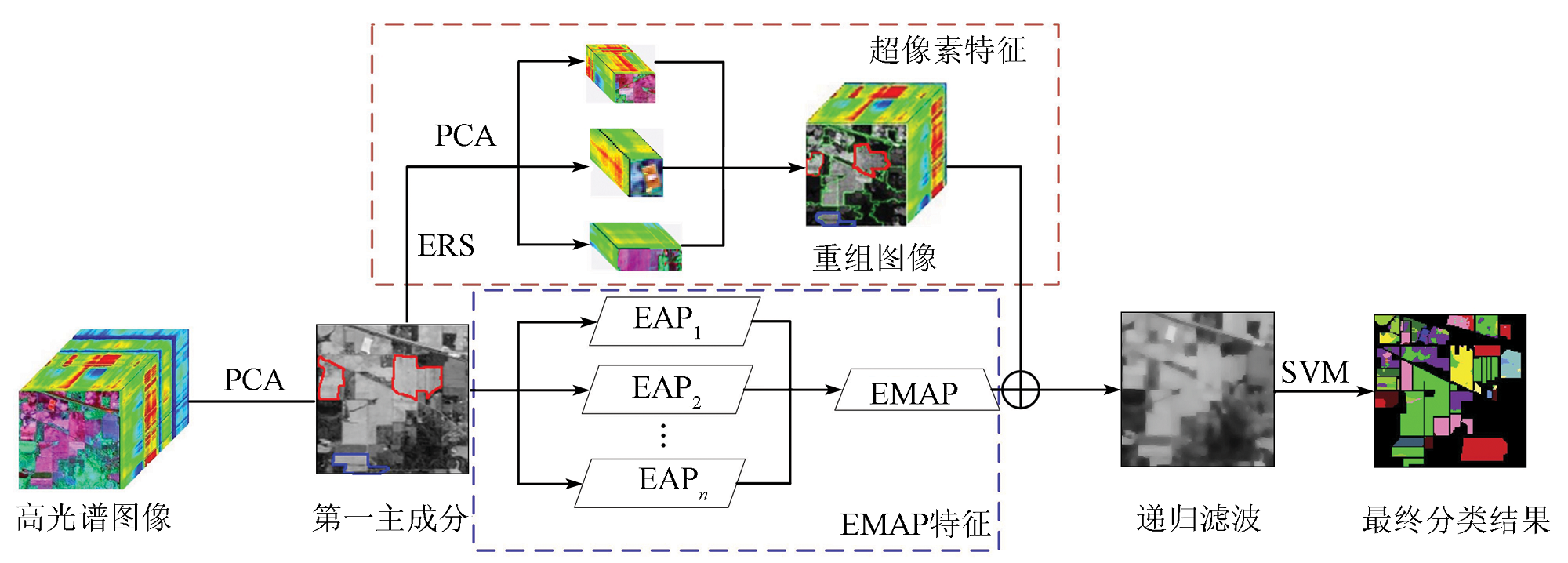
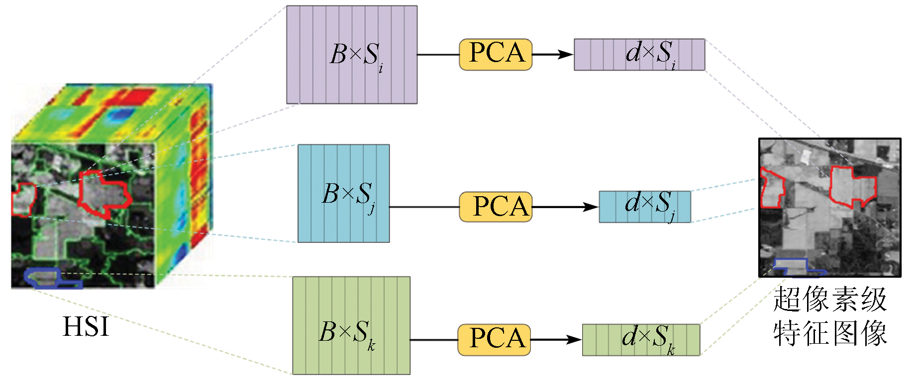
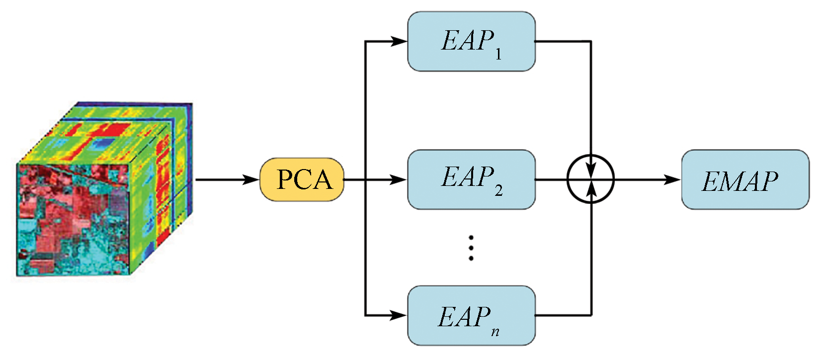
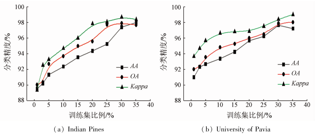
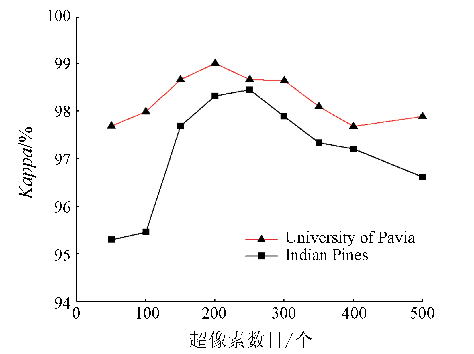
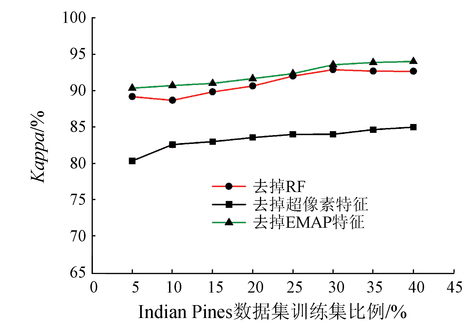
Abstract Superpixel segmentation-based image processing has been extensively used for the classification of hyperspectral images (HSI) in recent years. However, it fails to fully extract the HSI information at a single scale, and its classification process highly depends on parameters. Given the insufficient spatial information utilization by the superpixel segmentation-based HSI classification technology, this study proposed an HSI classification method that combines the superpixel segmentation method and the extended multi-attribute profile (EMAP) method. First, the superpixel segmentation and EMAP methods were employed to extract superpixel-level and pixel-level HSI features, respectively. By fusing the two types of features, the resulting images displayed complete HSI structural characteristics. To eliminate information redundancy, the fused images were subjected to spectral filtering through the recursive filtering method. Finally, the features were input to the support vector machine (SVM) for pixel tag determination. Experiments on the Indian Pines and University of Pavia datasets analyzed the effects of parameter variations on classification accuracy. Compared with the S3-PCA algorithm, the method proposed in this study exhibited superior classification accuracy and Kappa coefficient, which were improved by 3.55 and 2.88 percentage points, respectively.
|
| Keywords
hyperspectral image classification
information fusion
feature extraction
superpixel segmentation
|
|
|
|
Issue Date: 21 December 2023
|
|
|
| [1] |
Camps-Valls G, Tuia D, Bruzzone L, et al. Advances in hyperspectral image classification:Earth monitoring with statistical learning methods[J]. IEEE Signal Processing Magazine, 2014, 31(1):45-54.
|
| [2] |
Yan L, Zhu R, Mo N, et al. Cross-domain distance metric learning framework with limited target samples for scene classification of aerial images[J]. IEEE Transactions on Geoscience and Remote Sensing, 2019, 57(6):3840-3857.
doi: 10.1109/TGRS.36
url: https://ieeexplore.ieee.org/xpl/RecentIssue.jsp?punumber=36
|
| [3] |
Lu X, Zhang W, Li X. A hybrid sparsity and distance-based discrimination detector for hyperspectral images[J]. IEEE Transactions on Geoscience and Remote Sensing, 2018, 56(3):1704-1717.
doi: 10.1109/TGRS.2017.2767068
url: http://ieeexplore.ieee.org/document/8128904/
|
| [4] |
Horstrand P, Diaz M, Guerra R, et al. A novel hyperspectral anomaly detection algorithm for real-time applications with push-broom sensors[J]. IEEE Journal of Selected Topics in Applied Earth Observations and Remote Sensing, 2019, 12(12):4787-4797.
doi: 10.1109/JSTARS.2019.2919911
|
| [5] |
Shimoni M, Haelterman R, Perneel C. Hypersectral imaging for military and security applications:Combining myriad processing and sensing techniques[J]. IEEE Geoscience and Remote Sensing Magazine, 2019, 7(2):101-117.
doi: 10.1109/MGRS.2019.2902525
|
| [6] |
Tong X Y, Xia G S, Lu Q, et al. Land-cover classification with high-resolution remote sensing images using transferable deep models[J/OL]. arXiv, 2018(2018-07-16)[2022-10-04]. https://arxiv.org/abs/1807.05713v2.
url: https://arxiv.org/abs/1807.05713v2
|
| [7] |
Krupnik D, Khan S-D. Close-range,ground-based hyperspectral imaging for mining applications at various scales:Review and case studies[J]. Earth-Science Reviews, 2019, 198:102952.
doi: 10.1016/j.earscirev.2019.102952
url: https://linkinghub.elsevier.com/retrieve/pii/S001282521930251X
|
| [8] |
Li W, Du Q, Zhang F, et al. Hyperspectral image classification by fusing collaborative and sparse representations[J]. IEEE Journal of Selected Topics in Applied Earth Observations and Remote Sensing, 2016, 9(9):4178-4187.
doi: 10.1109/JSTARS.4609443
url: https://ieeexplore.ieee.org/xpl/RecentIssue.jsp?punumber=4609443
|
| [9] |
Kang X, Li S, Benediktsson J A. Spectral-spatial hyperspectral image classification with edge-preserving filtering[J]. IEEE Transactions on Geoscience and Remote Sensing, 2014, 52(5):2666-2677.
doi: 10.1109/TGRS.2013.2264508
url: http://ieeexplore.ieee.org/document/6553593/
|
| [10] |
Liang J, Zhou J, Gao Y. Tensor morphological profile for hyperspectral image classification[C]// IEEE International Conference on Image Processing.IEEE, 2016, 20(6):25-39
|
| [11] |
付航, 孙根云, 赵云华, 等. 多尺度超像素分割和奇异谱分析的高光谱影像分类[J]. 中国图象图形学报, 2021, 26(8):1978-1993.
|
| [11] |
Fu H, Sun G Y, Zhao Y H, et al. Combining multiscale superpixel segmentation and singular spectral analysis for hyperspectral image classification[J]. Journal of Image and Graphics, 2021, 26(8):1978-1993.
|
| [12] |
Liao J, Wang L, Zhao G, et al. Hyperspectral image classification based on bilateral filter with linear spatial correlation information[J]. International Journal of Remote Sensing, 2019, 40(17):6861-6883.
doi: 10.1080/01431161.2019.1597301
url: https://www.tandfonline.com/doi/full/10.1080/01431161.2019.1597301
|
| [13] |
Feng J, Zhang J, Zhang Y. A multiview spectral-spatial feature extraction and fusion framework for hyperspectral image classification[J]. IEEE Geoscience and Remote Sensing Letters, 2021, 19:5504805.
|
| [14] |
Ren L, Zhao L, Wang Y. A superpixel-based dual window RX for hyperspectral anomaly detection[J]. IEEE Geoscience and Remote Sensing Letters, 2020, 17(7):1233-1237.
doi: 10.1109/LGRS.8859
url: https://ieeexplore.ieee.org/xpl/RecentIssue.jsp?punumber=8859
|
| [15] |
Sellars P, Aviles-Rivero A, Schonlieb C B. Superpixel contracted graph-based learning for hyperspectral image classification[J]. IEEE Transactions on Geoscience and Remote Sensing, 2020, 58(6):4180-4193.
doi: 10.1109/TGRS.36
url: https://ieeexplore.ieee.org/xpl/RecentIssue.jsp?punumber=36
|
| [16] |
Jiang J, Ma J, Chen C, et al. SuperPCA:A superpixelwise PCA approach for unsupervised feature extraction of hyperspectral imagery[J]. IEEE Transactions on Geoscience and Remote Sensing, 2018, 56(8):4581-4593.
doi: 10.1109/TGRS.2018.2828029
url: https://ieeexplore.ieee.org/document/8390924/
|
| [17] |
Zhang X, Jiang X, Jiang J, et al. Spectral-spatial and superpixelwise PCA for unsupervised feature extraction of hyperspectral imagery[J]. IEEE Transactions on Geoscience and Remote Sensing, 2021, 60:552210.
|
| [18] |
Beirami A B, Mokhtarzade M. Band grouping SuperPCA for feature extraction and extended morphological profile production from hyperspectral images[J]. IEEE Geoscience and Remote Sensing Letters, 2020, 17(11):1953-1957.
doi: 10.1109/LGRS.8859
url: https://ieeexplore.ieee.org/xpl/RecentIssue.jsp?punumber=8859
|
| [19] |
Jia S, Deng X, Xu M, et al. Superpixel-level weighted label propagation for hyperspectral image classification[J]. IEEE Transactions on Geoscience and Remote Sensing, 2020, 58(7):5077-5091.
doi: 10.1109/TGRS.36
url: https://ieeexplore.ieee.org/xpl/RecentIssue.jsp?punumber=36
|
| [20] |
王扣准, 黄睿. 利用多属性剖面与双边滤波的高光谱影像分类[J]. 遥感信息, 2016, 31(6):104-109.
|
| [20] |
Wang K Z, Huang R. Hyperspectral image classification using extended multi-attribute profiles and guide bilateral filter[J]. Remote Sensing Information, 2016, 31(6):104-109.
|
| [21] |
罗建华, 李明奇, 郑泽忠, 等. 基于深度卷积神经网络的高光谱遥感图像分类[J]. 西华大学学报(自然科学版), 2017, 36(4):13-20.
|
| [21] |
Luo J H, Li M Q, Zheng Z Z, et al. Hyperspectral remote sensing images classification using a deep convolutional neural network model[J]. Journal of Xihua University (Natural Science Edition), 2017, 36(4):13-20.
|
| [22] |
付光远, 辜弘炀, 汪洪桥. 基于加权K近邻和卷积神经网络的高光谱图像分类[J]. 计算机应用研究, 2018, 35(8):2540-2543.
|
| [22] |
Fu G Y, Gu H Y, Wang H Q. Hyperspectral image classification based on weighted KNN and CNN[J]. Application Research of Computers. 2018, 35(8):2540-2543.
|
|
Viewed |
|
|
|
Full text
|
|
|
|
|
Abstract
|
|
|
|
|
Cited |
|
|
|
|
| |
Shared |
|
|
|
|
| |
Discussed |
|
|
|
|
 2023,
Vol. 35
2023,
Vol. 35