|
|
 |
|

|
|
|
A method for hyperspectral inversion of element contents for soil-quality evaluation of cultivated land |
YI Zifang1,2( ), ZHOU Leilei1,2, LUO Jianlan1, CAO Li2() ), ZHOU Leilei1,2, LUO Jianlan1, CAO Li2() |
1. Hunan Geophysical and Geochemical Institute, Changsha 410116, China
2. Key Laboratory of Natural Resources Monitoring and Supervision in Southern Hilly Region, Ministry of Natural Resources, Changsha 410119, China |
|
|
|
|
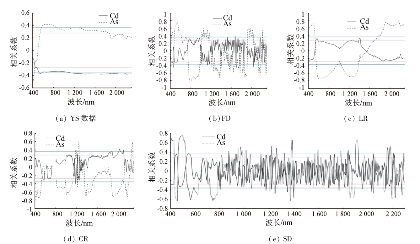
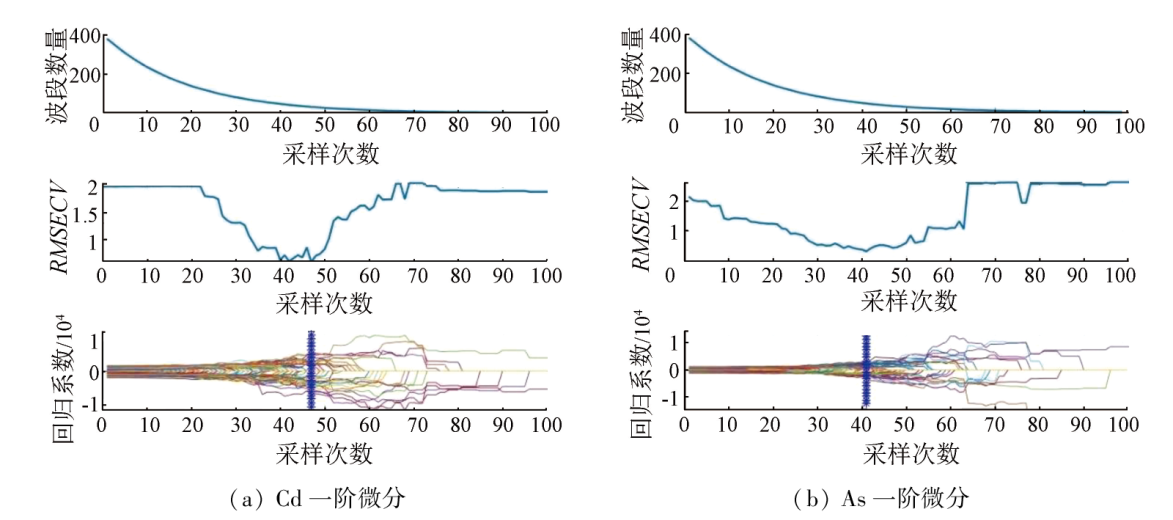
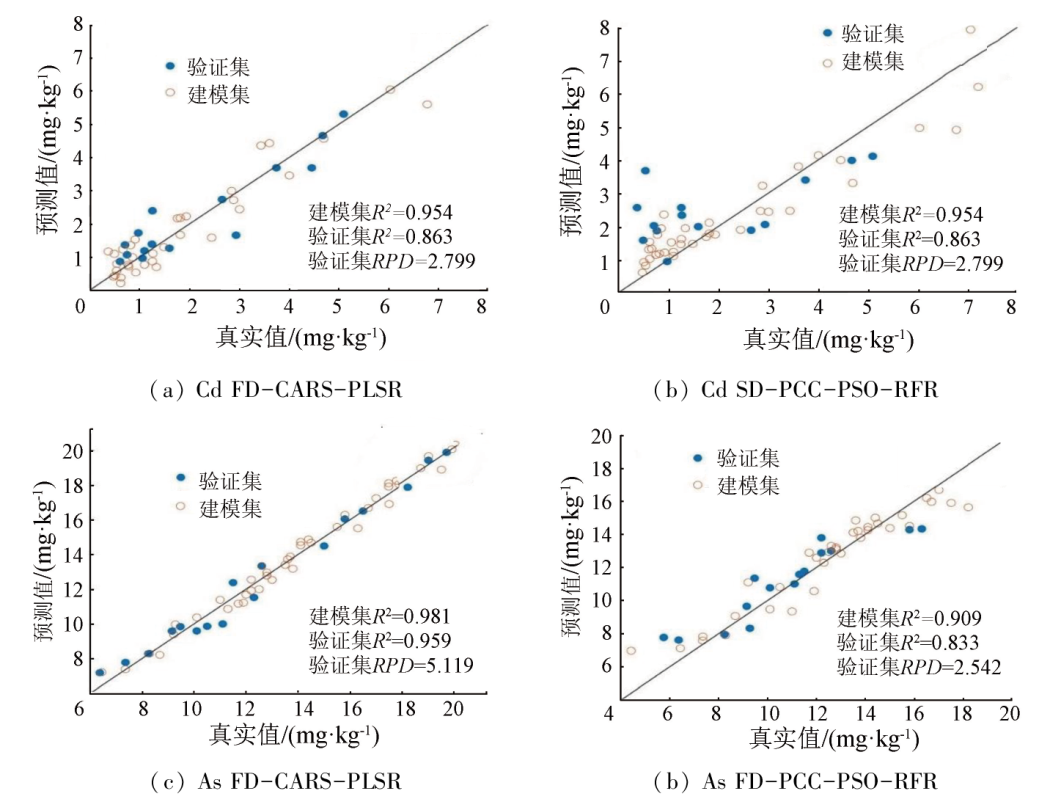
Abstract To explore the feasibility and accuracy of the method of utilizing hyperspectral data to estimate the contents of elements Cd and As for soil quality elevation of cultivated land, this study delves into the extraction of characteristic bands of the spectra of both elements and the modeling of quantitative hyperspectral inversion. The characteristic bands of spectra were extracted using multiple methods derived from the combination of four spectral transformations and two feature selection methods, with the former comprising first-order /second-order differential (FD/SD), reciprocal logarithm (LR), and continuum removal (CR) and the latter consisting of the competitive adaptive reweighted sampling (CARS) method and the Pearson correlation coefficient (PCC) analysis. Based on this, the element content inversion was conducted using the partial least squares regression (PLSR) and the particle swarm optimization optimized random forest regression (PSO-RFR), followed by the verification of inversion accuracy. The results indicate that the FD-CARS-PLSR inversion model exhibited the best prediction effect for both elements, with maximum determination coefficients R2 of 0.863 and 0.959 and relative percent differences (RPDs) of 2.799 and 5.119 for Cd and As, respectively. The FD and SD spectral transformations combined with the CARS method can improve the accuracy of the PLSR inversion model. The results of this study can provide a reference for the rapid estimation of the contents of Cd and As in soil.
|
| Keywords
hyperspectral remote sensing
spectral transformation
characteristic band selection
partial least squares regression
competitive adaptive reweighted sampling
|
|
|
|
Issue Date: 03 September 2024
|
|
|
| [1] |
张东辉, 赵英俊, 陆冬华, 等. 高光谱在土壤重金属信息提取中的应用与实现[J]. 土壤通报, 2018, 49(1):31-37.
|
| [1] |
Zhang D H, Zhao Y J, Lu D H, et al. Application and realization of hyperspectral information extraction of heavy metals in soil[J]. Chinese Journal of Soil Science, 2018, 49(1):31-37.
|
| [2] |
余涛, 蒋天宇, 刘旭, 等. 土壤重金属污染现状及检测分析技术研究进展[J]. 中国地质, 2021, 48(2):460-476.
|
| [2] |
Yu T, Jiang T Y, Liu X, et al. Research progress in current status of soil heavy metal pollution and analysis technology[J]. Geology in China, 2021, 48(2):460-476.
|
| [3] |
贺军亮, 张淑媛, 查勇, 等. 高光谱遥感反演土壤重金属含量研究进展[J]. 遥感技术与应用, 2015, 30(3):407-412.
doi: 10.11873/j.issn.1004\|0323.2015.3.0407
|
| [3] |
He J L, Zhang S Y, Zha Y, et al. Review of retrieving soil heavy metal content by hyperspectral remote sensing[J]. Remote Sensing Technology and Application, 2015, 30(3):407-412.
|
| [4] |
张静静, 周卫红, 邹萌萌, 等. 高光谱遥感监测大面积土壤重金属污染的研究现状、原理及展望[J]. 江苏农业科学, 2018, 46(12):9-13.
|
| [4] |
Zhang J J, Zhou W H, Zou M M, et al. Research status,principle and prospect of hyperspectral remote sensing monitoring of heavy metal pollution in large areas[J]. Jiangsu Agricultural Sciences, 2018, 46(12):9-13.
|
| [5] |
刘彦平, 罗晴, 程和发. 高光谱遥感技术在土壤重金属含量测定领域的应用与发展[J]. 农业环境科学学报, 2020, 39(12):2699-2709.
|
| [5] |
Liu Y P, Luo Q, Cheng H F. Application and development of hyperspectral remote sensing technology to determine the heavy metal content in soil[J]. Journal of Agro-Environment Science, 2020, 39(12):2699-2709.
|
| [6] |
杨晓宇, 包妮沙, 曹粤, 等. 基于无人机成像光谱技术的农田土壤养分估测及制图[J]. 地理与地理信息科学, 2021, 37(5):38-45.
|
| [6] |
Yang X Y, Bao N S, Cao Y, et al. Estimation and mapping of soil nutrient in farmland based on UAV imaging spectrometry[J]. Geography and Geo-Information Science, 2021, 37(5):38-45.
|
| [7] |
雷宇斌, 刘宁, 郭云开, 等. 高光谱组合变换下土壤含量模型反演研究[J]. 测绘工程, 2018, 27(11):71-76.
|
| [7] |
Lei Y B, Liu N, Guo Y K, et al. Inversion of soil Cd content with GWR model under hyper-spectral combined transformation[J]. Engineering of Surveying and Mapping, 2018, 27(11):71-76.
|
| [8] |
褚小立, 袁洪福, 陆婉珍. 近红外分析中光谱预处理及波长选择方法进展与应用[J]. 化学进展, 2004, 16(4):528-542.
|
| [8] |
Chu X L, Yuan H F, Lu W Z. Progress and application of spectral data pretreatment and wavelength selection methods in NIR analytical technique[J]. Progress in Chemistry, 2004, 16(4):528-542.
|
| [9] |
宋相中, 唐果, 张录达, 等. 近红外光谱分析中的变量选择算法研究进展[J]. 光谱学与光谱分析, 2017, 37(4):1048-1052.
|
| [9] |
Song X Z, Tang G, Zhang L D, et al. Research advance of variable selection algorithms in near infrared spectroscopy analysis[J]. Spectroscopy and Spectral Analysis, 2017, 37(4):1048-1052.
|
| [10] |
袁自然, 魏立飞, 张杨熙, 等. 优化CARS结合PSO-SVM算法农田土壤重金属砷含量高光谱反演分析[J]. 光谱学与光谱分析, 2020, 40(2):567-573.
|
| [10] |
Yuan Z R, Wei L F, Zhang Y X, et al. Hyperspectral inversion and analysis of heavy metal arsenic content in farmland soil based on optimizing CARS combined with PSO-SVM algorithm[J]. Spectroscopy and Spectral Analysis, 2020, 40(2):567-573.
|
| [11] |
陈元鹏, 张世文, 罗明, 等. 基于高光谱反演的复垦区土壤重金属含量经验模型优选[J]. 农业机械学报, 2019, 50(1):170-179.
|
| [11] |
Chen Y P, Zhang S W, Luo M, et al. Empirical model optimization of hyperspectral inversion of heavy metal content in reclamation area[J]. Transactions of the Chinese Society for Agricultural Machinery, 2019, 50(1):170-179.
|
| [12] |
金昭, 吕建树. 基于机器学习模型的区域土壤重金属空间预测精度比较研究[J]. 地理研究, 2022, 41(6):1731-1747.
doi: 10.11821/dlyj020210528
|
| [12] |
Jin Z, Lyu J S. Comparison of the accuracy of spatial prediction for heavy metals in regional soils based on machine learning models[J]. Geographical Research, 2022, 41(6):1731-1747.
|
| [13] |
涂宇龙, 邹滨, 姜晓璐, 等. 矿区土壤Cu含量高光谱反演建模[J]. 光谱学与光谱分析, 2018, 38(2):575-581.
|
| [13] |
Tu Y L, Zou B, Jiang X L, et al. Hyperspectral remote sensing based modeling of Cu content in mining soil[J]. Spectroscopy and Spectral Analysis, 2018, 38(2):575-581.
|
| [14] |
Li H D, Liang Y Z, Xu Q S, et al. Key wavelengths screening using competitive adaptive reweighted sampling method for multivariate calibration[J]. Analytica Chimica Acta, 2009, 648(1):77-84.
doi: 10.1016/j.aca.2009.06.046
pmid: 19616692
|
| [15] |
Tan K, Wang H M, Zhang Q Q, et al. An improved estimation model for soil heavy metal(loid) concentration retrieval in mining areas using reflectance spectroscopy[J]. Journal of Soils and Sediments, 2018, 18(5):2008-2022.
|
| [16] |
孙波, 张弛, 尹世超, 等. 基于PSO-RF的GNSS-IR土壤湿度反演方法研究[J]. 无线电工程, 2021, 51(10):1080-1085.
|
| [16] |
Sun B, Zhang C, Yin S C, et al. Research on GNSS-IR soil moisture inversion method based on PSO-RF[J]. Radio Engineering, 2021, 51(10):1080-1085.
|
| [17] |
范升旭, 杨春曦, 杨启良, 等. 基于粒子群-随机森林算法和气象数据的三七叶面积生长预测模型[J]. 中草药, 2022, 53(10):3103-3110.
|
| [17] |
Fan X X, Yang C X, Yang Q L, et al. Prediction model of Panax notoginseng leaf area growth based on particle swarm-optimization random forest algorithm and meteorological data[J]. Chinese Traditional and Herbal Drugs, 2022, 53(10):3103-3110.
|
| [18] |
魏丹萍, 郑光辉. 高光谱反射率的滨海地区土壤全磷含量反演[J]. 光谱学与光谱分析, 2022, 42(2):517-523.
|
| [18] |
Wei D P, Zheng G H. Estimation of soil total phosphorus content in coastal areas based on hyperspectral reflectance[J]. Spectroscopy and Spectral Analysis, 2022, 42(2):517-523.
|
| [19] |
Malley D F, Williams P C. Use of near-infrared reflectance spectroscopy in prediction of heavy metals in freshwater sediment by their association with organic matter[J]. Environmental Science & Technology, 1997, 31(12):3461-3467.
|
| [20] |
李冠稳, 高小红, 肖能文, 等. 基于sCARS-RF算法的高光谱估算土壤有机质含量[J]. 发光学报, 2019, 40(8):1030-1039.
|
| [20] |
Li G W, Gao X H, Xiao N W, et al. Estimation soil organic matter contents with hyperspectra based on sCARS and RF algorithms[J]. Chinese Journal of Luminescence, 2019, 40(8):1030-1039.
|
|
Viewed |
|
|
|
Full text
|
|
|
|
|
Abstract
|
|
|
|
|
Cited |
|
|
|
|
| |
Shared |
|
|
|
|
| |
Discussed |
|
|
|
|
 2024,
Vol. 36
2024,
Vol. 36