|
|
 |
|

|
|
|
Application of MODIS remote sensing products in the estimation of grass yield in Sanjiang Source Area |
| Xifeng CAO1, Lin SUN1, Zifei ZHAO1, Xiaofeng HAN2, Mingjie YAN3 |
1. College of Geomatics, Shandong University of Science and Technology, Qingdao 266590, China
2. College of Mathematics and Systems Science, Shandong University of Science and Technology, Qingdao 266590, China
3. Shandong Geo-Surveying and Mapping Institute, Jinan 250000, China |
|
|
|
|
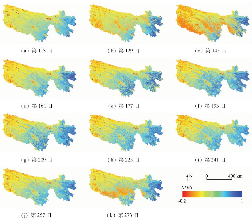
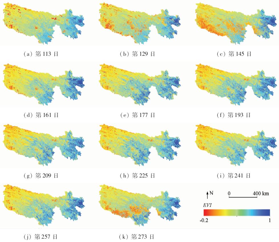
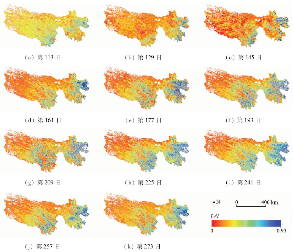
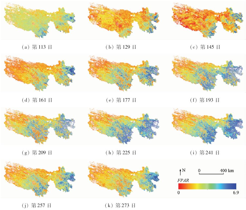
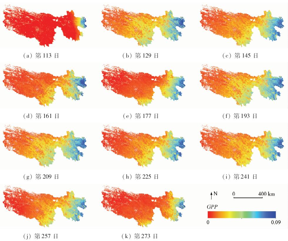
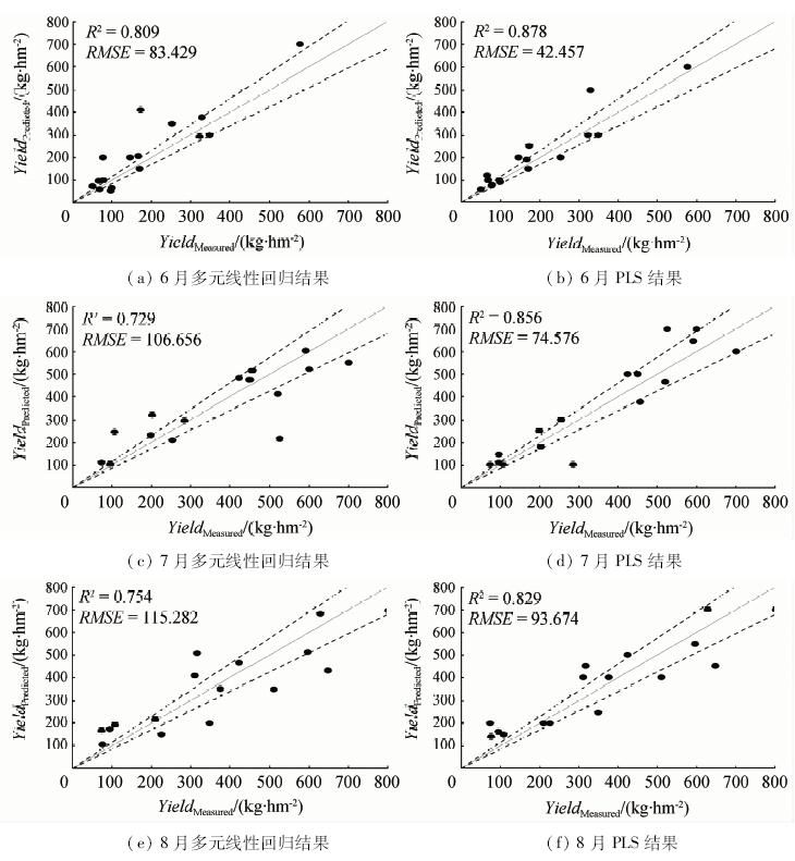
Abstract The growth of grassland in Sanjiang Source Area has an important influence on the development of livestock husbandry and the ecological balance of Sanjiang ecosystem. It is of great importance to estimate grass yield reasonably and accurately. In view of the larger area and the complicated surface structure, this study is aimed at predicting the grass yield by using MODIS product data. The authors built a prediction model of grass yield in Sanjiang by using six kinds of MODIS products (LAI, FPAR, NDVI, EVI, GPP and LST) from April 2009 to October 2009 and, in combination with partial least squares regression (PLS) and multiple linear regression method, accomplished estimation of grass yield by remote sensing. Based on the built model, the authors used the 140 scene data from April to October 2011 for application testing, and then compared the predicting results with standard values which were measured from June to August 2011 in 16 grassland ecological monitoring stations in Sanjiang. The results show that there is a good correlation between grass yield estimated based on the six MODIS products and the measured actual grass yield. A comparison with the result of multiple linear regression shows that the result of PLS has a higher coefficient (R 2≈0.829~0.878) and lower root mean squared error (RMSE≈42.457~93.674 kg·hm -2).
|
| Keywords
Sanjiang Source Area
MODIS
time series
partial least squares regression
grass yield estimation
|
|
|
|
Issue Date: 07 December 2018
|
|
|
| [1] |
刘珍环, 李正国, 唐鹏钦 , 等. 近30年中国水稻种植区域与产量时空变化分析[J]. 地理学报, 2013,68(5):680-693.
doi: 10.11821/xb201305009
url: http://d.wanfangdata.com.cn/Periodical_dlxb201305009.aspx
|
| [1] |
Liu Z H, Li Z G, Tang P Q , et al. Spatial-temporal changes of rice area and production in China during 1980—2010[J]. Acta Geographica Sinica, 2013,68(5):680-693.
|
| [2] |
陈仲新, 任建强, 唐华俊 , 等. 农业遥感研究应用进展与展望[J]. 遥感学报, 2016,20(5):748-767.
doi: 10.11834/jrs.20166214
url: http://d.wanfangdata.com.cn/Periodical/ygxb201605007
|
| [2] |
Chen Z X, Ren J Q, Tang H J , et al. Progress and perspectives on agricultural remote sensing research and applications in China[J]. Journal of Remote Sensing, 2016,20(5):748-767.
|
| [3] |
侯英雨, 王健林, 毛留喜 , 等. 美国玉米和小麦产量动态预测遥感模型[J]. 生态学杂志, 2009,28(10):2142-2146.
|
| [3] |
Hou Y Y, Wang J L, Mao L X , et al. Dynamic prediction model of corn and wheat yield in USA based on remote sensing[J]. Chinese Journal of Ecology, 2009,28(10):2142-2146.
|
| [4] |
任建强, 陈仲新, 唐华俊 , 等. 基于遥感信息与作物生长模型的区域作物单产模拟[J]. 农业工程学报, 2011,27(8):257-264.
doi: 10.3969/j.issn.1002-6819.2011.08.045
url: http://d.wanfangdata.com.cn/Periodical/nygcxb201108045
|
| [4] |
Ren J Q, Chen Z X, Tang H J , et al. Regional crop yield simulation based on crop growth model and remote sensing data[J]. Transactions of the Chinese Society of Agricultural Engineering, 2011,27(8):257-264.
|
| [5] |
胡莹瑾, 崔海明 . 基于RS和GIS的农作物估产方法研究进展[J]. 国土资源遥感, 2014,26(4):1-7.doi: 10.6046/gtzyyg.2014.04.01.
doi: 10.6046/gtzyyg.2014.04.01
|
| [5] |
Hu Y J, Cui H M . Process in the study of crop estimation methods based on remote sensing and geographic information system[J]. Remote Sensing for Land and Resourses, 2014,26(4):1-7.doi: 10.6046/gtzyyg.2014.04.01.
|
| [6] |
郭连云, 赵年武, 田辉春 . 气候变暖对三江源区高寒草地牧草生育期的影响[J]. 草业科学, 2011,28(4):618-625.
url: http://d.wanfangdata.com.cn/Periodical/caoyekx201104019
|
| [6] |
Guo L Y, Zhao N W, Tian H C . Impacts of climatic warming on reproductive stages of forages growing in alpine grassland of the Three River Sources Areas[J]. Pratacultural Science, 2011,28(4):618-625.
|
| [7] |
黄爱纤, 张新跃, 唐川江 , 等. 川西北牧区水热条件牧草产量的相关性[J]. 草业科学, 2015,32(5):754-759.
doi: 10.11829\j.issn.1001-0629.2014-0319
|
| [7] |
Huang A X, Zhang X Y, Tang C J , et al. Correlation between grassland hydrothermal conditions and forage yield of pastoral area in Northwest Sichuan[J]. Pratacultural Science, 2015,32(5):754-759.
|
| [8] |
任建强, 陈仲新, 周清波 , 等. MODIS植被指数的美国玉米单产遥感估测[J]. 遥感学报, 2015,19(4):568-577.
doi: 10.11834/jrs.20154146
url: http://d.wanfangdata.com.cn/Periodical/ygxb201504004
|
| [8] |
Ren J Q, Chen Z X, Zhou Q B , et al. MODIS vegetation index data used for estimating corn yield in USA[J]. Journal of Remote Sensing, 2015,19(4):568-577.
|
| [9] |
Becker-Reshef I, Vermote E, Lindeman M , et al. A generalized regression-based model for forecasting for winter wheat yields in Kansas and Ukraine using MODIS data[J].Remote Sensing of Environment, 2010(114):1312-1323.
|
| [10] |
Mkhabela M S, Bullock P, Raj S , et al. Crop yield forecasting on the Canadian Prairies using MODIS NDVI data[J].Agricultural and Forest Meteorology, 2011(151):385-393.
|
| [11] |
Bolton D K, Friedl M A . Forecasting crop yield using remotely sensed vegetation indices and crop phenology metrics[J]. Agricultural and Forest Meteorology, 2013,173:74-84.
doi: 10.1016/j.agrformet.2013.01.007
url: https://linkinghub.elsevier.com/retrieve/pii/S0168192313000129
|
| [12] |
Kastens J H, Kastens T L, Kastens D L , et al. Image masking for crop yield forecasting using AVHRR NDVI time series imagery[J]. Remote Sensing of Environment, 2005,99(3):341-356.
doi: 10.1016/j.rse.2005.09.010
url: http://linkinghub.elsevier.com/retrieve/pii/S0034425705003056
|
| [13] |
Doraiswamy P C, Hatfield J L, Jackson T J , et al. Crop condition and yield simulations using Landsat and MODIS[J]. Remote Sensing of Environment, 2004,92(4):548-559.
doi: 10.1016/j.rse.2004.05.017
url: http://linkinghub.elsevier.com/retrieve/pii/S0034425704001853
|
|
Viewed |
|
|
|
Full text
|
|
|
|
|
Abstract
|
|
|
|
|
Cited |
|
|
|
|
| |
Shared |
|
|
|
|
| |
Discussed |
|
|
|
|
 2018,
Vol. 30
2018,
Vol. 30