|
|
 |
|

|
|
|
Exploring the spatiotemporal evolution of bottomland in Dongting Lake based on multisource remote sensing |
YU Shuchen1,2,3,4( ), QIU Luo2,3,4,5(), HE Qiuhua1,2,3,4, JIN Xiaoyan1, LI Jiabao1, YU Deqing1,2,3,4 ), QIU Luo2,3,4,5(), HE Qiuhua1,2,3,4, JIN Xiaoyan1, LI Jiabao1, YU Deqing1,2,3,4 |
1. Hunan Natural Resources Affairs Center, Changsha 410004, China
2. Hunan Key Laboratory of Remote Sensing Monitoring of Ecological Environment in Dongting Lake Area, Changsha 410007, China
3. Dongting Lake Basin Ecological Protection and Restoration Engineering Technology Innovation Center, Ministry of Natural Resources, Changsha 410004, China
4. Dongting Lake Natural Resource Ecosystem Field Scientific Research Station, Ministry of Natural Resources, Changsha 410007, China
5. School of Computational Sciences and Electronics, Hunan Institute of Engineering, Xiangtan 411104, China |
|
|
|
|
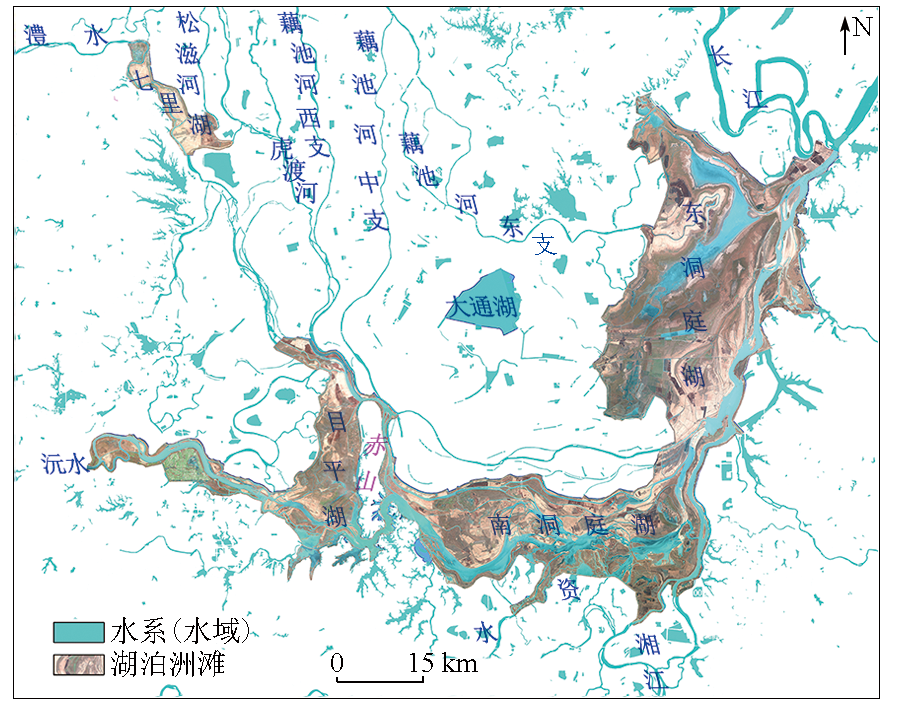
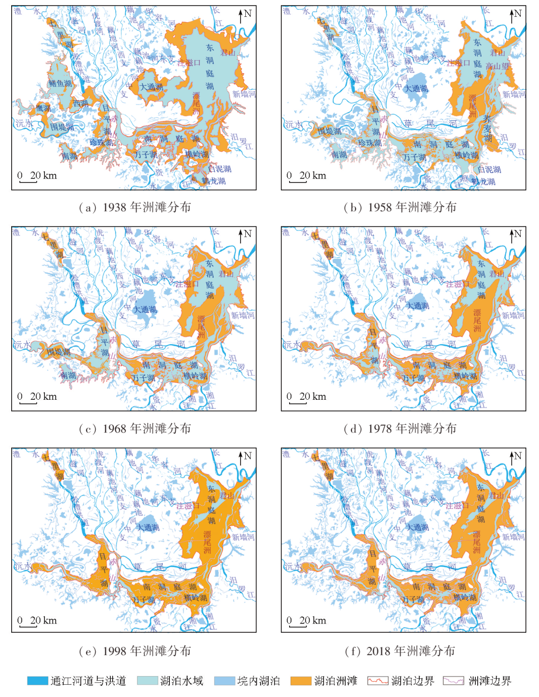
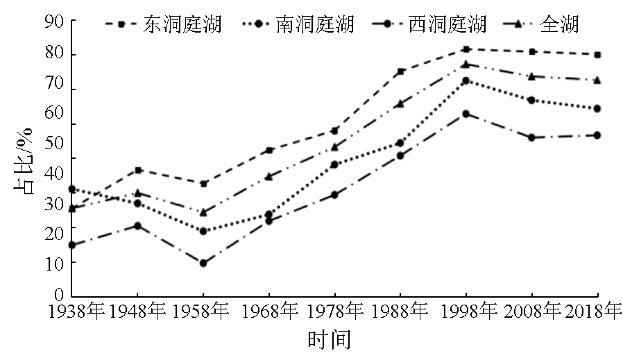
Abstract To explore the spatiotemporal evolution of the bottomland in Dongting Lake since the middle stage of the Republic of China, this study examined the historical topographic maps and aerospace remote sensing data concerning the study area for over 10 time periods since the 1930s. Based on remote sensing image interpretation, statistical data analysis, and historical comparison, this study analyzed the temporal variations in the bottomland area of Dongting Lake in various periods to infer the corresponding spatial distributions of the bottomland. The results show that the spatial development of the bottomland in Dongting Lake was primarily characterized by the rapidly advancing delta at the mouth of the east branch of the Ouchi River and Piaowei Islet in East Dongting Lake, the alluvial deposits along the Caowei and Songzhu rivers in the north of South Dongting Lake, and the “Jiangnan Grassland” landscape formed by the bottom uplift of Qili and Muping lakes. The bottomland area in Dongting Lake expanded from 1 622.17 km2 in 1 938 to 1 962.28 km2 in 2018, coupled with the 980.96 km2 of reclaimed high bottomland, suggesting a net increase of 1 321.07 km2. In terms of spatial distribution, the bottomland area exhibited an undulating trend rather than a continuous increase. It manifested a significant expansion from 1938 to 1948 and 1958 to 1998 but a slow shrinkage from 1948 to 1958 and 1998 to 2018. Overall, the results of this study provide objective data for preserving lakeshore ecosystems and biodiversity and serving ecological restoration and environmental conservation in the Yangtze River basin.
|
| Keywords
Dongting Lake area
bottomland evolution
temporal variation
multisource remote sensing technology
|
|
|
|
Issue Date: 09 May 2025
|
|
|
| [1] |
王大博, 任杰, 代娟, 等. 水位波动对洞庭湖洲滩潜流带水热传输影响[J]. 长江流域资源与环境, 2022, 31(3):685-697.
|
| [1] |
Wang D B, Ren J, Dai J, et al. Influence of water level fluctuation on water and heat transfer in the island riparian zone of Dongting Lake[J]. Resources and Environment in the Yangtze Basin, 2022, 31(3):685-697.
|
| [2] |
何培金. 洞庭湖志[M]. 长沙: 岳麓书社, 2003.
|
| [2] |
He P J. Dongting lake annals[M]. Changsha: Yuelu Press, 2003.
|
| [3] |
中华民国治安部警务司. 湖南省滨湖洲土视察团视察报告书[M]. 南京: 中华民国警察协会出版, 1947.
|
| [3] |
Police Affairs Division of the Ministry of Public Security of the Republic of China. Report on the inspection of the survey team of Hunan Province Binhu zhou soil[M]. Nanjing: Publication of the Police Association of the Republic of China, 1947.
|
| [4] |
陈宝顺, 周沐林, 孙锡良, 等. 湖南省洞庭湖区水文地质工程地质综合评价报告[R]. 北京: 全国地质资料馆, 1985.
|
| [4] |
Chen B S, Zhou M L, Sun X L, et al. Comprehensive evaluation report on hydrogeology and engineering geology of Dongting Lake area in Hunan Province[R]. Beijing: National Geological Information Center, 1985.
|
| [5] |
贺秋华, 余德清, 王伦澈, 等. 近400多年下荆江河段古河道演变过程及特征[J]. 地球科学, 2020, 45(6):1928-1936.
|
| [5] |
He Q H, Yu D Q, Wang L C, et al. Evolution process and characteristics of lower Jingjiang paleo-channel in recent 400 years[J]. Earth Science, 2020, 45(6):1928-1936.
|
| [6] |
王迪友, 邓文强, 杨帆. 三峡水库消落区生态环境现状及生物治理技术[J]. 湖北农业科学, 2012, 51(5):865-869.
|
| [6] |
Wang D Y, Deng W Q, Yang F. The status and bioremediation technology of ecological environment in water-level-fluctuating zone of the Three Gorges Reservoir[J]. Hubei Agricultural Sciences, 2012, 51(5):865-869.
|
| [7] |
贺秋华, 余德清, 余姝辰, 等. 三峡水库运行前后洞庭湖水资源量变化[J]. 地球科学, 2021, 46(1):293-307.
|
| [7] |
He Q H, Yu D Q, Yu S C, et al. Changes of Water Resources amount in Dongting Lake before and after the operation of the Three Gorges Reservoir[J]. Earth Science, 2021, 46(1):293-307.
|
| [8] |
余姝辰, 李长安, 余德清, 等. 洞庭湖区湖泊洲滩地表覆盖变化[J]. 地球科学, 2020, 45(6):1918-1927.
|
| [8] |
Yu S C, Li C A, Yu D Q, et al. Land cover change on beach of Dongting Lake’s beach[J]. Earth Science, 2020, 45(6):1918-1927.
|
| [9] |
李世杰, 冯徽徽, 王珍, 等. 近十年洞庭湖流域生态环境状况时空动态特征及影响因素[J]. 自然资源遥感, 2024, 36(1):179-188.doi:10.6046/zrzyyg.2022375.
|
| [9] |
Li S J, Feng W W, Wang Z, et al. Temporal and spatial dynamics of ecological environment in Dongting Lake basin in recent ten years and its influencing factors[J]. Remote Sensing for Natural Resources, 2024, 36(1):179-188.doi:10.6046/zrzyyg.2022375.
|
| [10] |
周松鹤, 黄万士. 洞庭湖区泥沙淤积分析[J]. 泥沙研究, 1985(2):62-67.
|
| [10] |
Zhou S H, Huang W S. Analysis of sediment deposition in Dongting Lake area[J]. Journal of Sediment Research, 1985(2):62-67.
|
| [11] |
杜耘, 蔡述明. 近代洞庭湖三角洲发育特征[J]. 世界科技研究与发展, 2000, 22(s1):5-8.
|
| [11] |
Du Y, Cai S M. The development character of Dongting Lake’ deltas in neoteric time[J]. World Sci-Tech R & D, 2000, 22(s1):5-8.
|
| [12] |
姜加虎, 黄群, 孙占东. 洞庭湖泥沙淤积与洲滩变化研究[J]. 人民长江, 2009, 40(14):74-75.
|
| [12] |
Jiang J H, Huang Q, Sun Z D. Study on sediment deposition and beach change in Dongting Lake[J]. Yangtze River, 2009, 40(14):74-75.
|
| [13] |
刘晓群, 易放辉, 栾震宇, 等. 东洞庭湖近期冲淤演变分析[J]. 泥沙研究, 2019, 44(4):25-32.
|
| [13] |
Liu X Q, Yi F H, Luan Z Y, et al. Processes of East Dongting Lake in recent period[J]. Journal of Sediment Research, 2019, 44(4):25-32.
|
| [14] |
郭小虎, 刘亚, 陈栋. 2022特枯年洞庭湖区洲滩面积变化特性分析[J]. 人民长江, 2023, 54(2):43-48.
|
| [14] |
Guo X H, Liu Y, Chen D. Analysis on beach and flat area change characteristics in Dongting Lake area in 2022 extreme dry year[J]. Yangtze River, 2023, 54(2):43-48.
|
| [15] |
姚仕明, 胡呈维, 渠庚, 等. 长江通江湖泊演变及其影响效应研究进展[J]. 长江科学院院报, 2022, 39(9):15-23.
doi: 10.11988/ckyyb.20220304
|
| [15] |
Yao S M, Hu C W, Qu G, et al. Research advances in morphological evolution of lakes connecting the Yangtze River and its influences[J]. Journal of Yangtze River Scientific Research Institute, 2022, 39(9):15-23.
|
| [16] |
中华人民共和国水利部. 中国河流泥沙公报—2020[M]. 北京: 中国水利水电出版社, 2021:6-18.
|
| [16] |
Ministry of Water Resources of the People’s Republic of China. China river sediment bulletin-2020[M]. Beijing: China Water & Power Press, 2021:6-18.
|
| [17] |
余德清, 余姝辰, 贺秋华, 等. 联合历史地图与遥感技术的洞庭湖百年萎缩监测[J]. 国土资源遥感, 2016, 28(3):116-122.doi:10.6046/gtzyyg.2016.03.19.
|
| [17] |
Yu D Q, Yu S C, He Q H, et al. Monitoring of Dongting Lake atrophy in the past 100 years by combining historical map and remote sensing technology[J]. Remote Sensing for Land and Resources, 2016, 28(3):116-122.doi:10.6046/gtzyyg.2016.03.19.
|
| [18] |
Schultz G A, Engman E T. Remote sensing in hydrology and water management[M]. Berlin:Springer, 2000.
|
|
Viewed |
|
|
|
Full text
|
|
|
|
|
Abstract
|
|
|
|
|
Cited |
|
|
|
|
| |
Shared |
|
|
|
|
| |
Discussed |
|
|
|
|
 2025,
Vol. 37
2025,
Vol. 37