|
|
 |
|

|
|
|
A granitic pegmatite information extraction method based on improved U-Net |
LI Wanyue1,2( ), LOU Debo1(), WANG Chenghui1, LIU Huan1, ZHANG Changqing1, FAN Yinglin3, DU Xiaochuan1,2 ), LOU Debo1(), WANG Chenghui1, LIU Huan1, ZHANG Changqing1, FAN Yinglin3, DU Xiaochuan1,2 |
1. MLR Key Laboratory of Metallogeny and Mineral Assessment, Institute of Mineral Resources, Chinese Academy of Geological Sciences, Beijing 100037, China
2. School of Earth Science and Resource, China University of Geosciences (Beijing), Beijing 100083, China
3. General Prospecting Institute of China National Administration of Coal Geology, Beijing 100039, China |
|
|
|
|
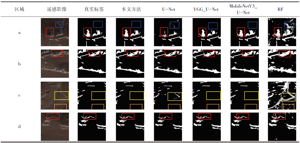
Abstract Identifying granitic pegmatite-type lithium deposits based on remote sensing technology is a significant method for lithium ore prospecting. To enhance the information extraction accuracy of the deep learning-based semantic segmentation method for granitic pegmatites, this study improved the classic U-Net network. A batch normalization module was added to the convolutional layer of the encoder part, with the ReLU activation function replaced by the ReLU6 activation function. Simultaneously, a composite loss function was constructed to improve operational efficiency and reduce the precision loss in the training process. The domestic GF-2 images of a granitic pegmatite-type lithium deposit were employed to create a dataset for experiments. The results show that the improved U-Net model effectively identified the information on granitic pegmatites in the study area covered by GF-2 images. Compared to the original U-Net network, U-Net model based on VGG backbone network, U-Net model based on MobileNetV3 backbone network, and conventional random forest model, the improved U-Net model has its average intersection over union increased by 14.69, 0.95, 5.08, and 35.34 percentage points, respectively. Moreover, its F1-score increased by 18.38, 1.02, 5.7, and 54.59 percentage points, respectively. Hence, the improved U-Net model achieves the high-precision automatic extraction of ore-bearing granitic pegmatite information from remote sensing images in areas with low vegetation coverage.
|
| Keywords
deep learning
granitic pegmatite
U-Net
GF-2
|
|
|
|
Issue Date: 14 June 2024
|
|
|
| [1] |
胡晓君, 李欢. 花岗伟晶岩型锂矿床研究进展及展望[J]. 中国有色金属学报, 2021, 31(11):3468-3488.
|
| [1] |
Hu X J, Li H. Research progress and prospect of granitic pegmatite-type lithium deposits[J]. The Chinese Journal of Nonferrous Metals, 2021, 31(11):3468-3488.
|
| [2] |
王登红. 关键矿产的研究意义、矿种厘定、资源属性、找矿进展、存在问题及主攻方向[J]. 地质学报, 2019, 93(6):1189-1209.
|
| [2] |
Wang D H. Study on critical mineral resources:Significance of research,determination of types,attributes of resources,progress of prospecting,problems of utilization,and direction of exploitation[J]. Acta Geologica Sinica, 2019, 93(6):1189-1209.
|
| [3] |
娄德波, 王登红, 李婉悦, 等. 国内外花岗伟晶岩型锂矿找矿预测研究进展[J]. 矿床地质, 2022, 41(5):975-988.
|
| [3] |
Lou D B, Wang D H, Li W Y, et al. Progress of prospecting prediction research for granitic pegmatite-type lithium deposits at home and abroad[J]. Mineral Deposits, 2022, 41(5):975-988.
|
| [4] |
陈衍景, 薛莅治, 王孝磊, 等. 世界伟晶岩型锂矿床地质研究进展[J]. 地质学报, 2021, 95(10):2971-2995.
|
| [4] |
Chen Y J, Xue L Z, Wang X L, et al. Progress in geological study of pegmatite-type lithium deposits in the world[J]. Acta Geologica Sinica, 2021, 95(10):2971-2995.
|
| [5] |
唐军. 浅析典型伟晶岩型锂矿床成矿地质特征[J]. 世界有色金属, 2020(14):143-144.
|
| [5] |
Tang J. A brief analysis of metallogenic characteristics of typical pegmatite type lithium deposits[J]. World Nonferrous Metals, 2020(14):143-144.
|
| [6] |
姜琪, 代晶晶, 王登红, 等. 光学遥感在识别花岗伟晶岩型锂矿床中的应用[J]. 矿床地质, 2021, 40(4):793-804.
|
| [6] |
Jiang Q, Dai J J, Wang D H, et al. Application of optical remote sensing to identifying granite pegmatite lithium deposits[J]. Mineral Deposits, 2021, 40(4):793-804.
|
| [7] |
Cardoso-Fernandes J, Teodoro A C, Lima A. Remote sensing data in lithium (Li) exploration:A new approach for the detection of Li-bearing pegmatites[J]. International Journal of Applied Earth Observation and Geoinformation, 2019, 76:10-25.
|
| [8] |
金谋顺, 高永宝, 李侃, 等. 伟晶岩型稀有金属矿的遥感找矿方法——以西昆仑大红柳滩地区为例[J]. 西北地质, 2019, 52(4):222-231.
|
| [8] |
Jin M S, Gao Y B, Li K, et al. Remote sensing prospecting method for pegmatite type rare metal deposit:Taking Dahongliutan area in western Kunlun for example[J]. Northwestern Geology, 2019, 52(4):222-231.
|
| [9] |
潘蒙, 唐屹, 肖瑞卿, 等. 甲基卡新3号超大型锂矿脉找矿方法[J]. 四川地质学报, 2016, 36(3):422-425,430.
|
| [9] |
Pan M, Tang Y, Xiao R Q, et al. The discovery of the superlarge Li ore vein X03 in the Jiajika ore district[J]. Acta Geologica Sichuan, 2016, 36(3):422-425,430.
|
| [10] |
姚佛军, 徐兴旺, 杨建民, 等. 戈壁浅覆盖区花岗岩中锂铍伟晶岩的ASTER遥感识别技术——以新疆镜儿泉地区为例[J]. 矿床地质, 2020, 39(4):686-696.
|
| [10] |
Yao F J, Xu X W, Yang J M, et al. A technology for identifying Li-Be pegmatite using ASTER remote sensing data in granite of Gobi shallow-covered area:A case study of recognition and prediction of Li-Be pegmatite in Jingerquan,Xinjiang[J]. Mineral Deposits, 2020, 39(4):686-696.
|
| [11] |
杜晓川, 娄德波, 徐林刚, 等. 基于GF-2影像和随机森林算法的花岗伟晶岩提取[J/OL]. 自然资源遥感, 2023(2023-01-18). https://kns.cnki.net/kcms/detail/10.1759.P.20230117.1030.007.html.
url: https://kns.cnki.net/kcms/detail/10.1759.P.20230117.1030.007.html
|
| [11] |
Du X C, Lou D B, Xu L G, et al. Extraction of granitic pegmatite based on GF-2 image and random forest algorithm[J/OL]. Remote Sensing for Natural Resources, 2023(2023-01-18). https://kns.cnki.net/kcms/detail/10.1759.P.20230117.1030.007.html.
url: https://kns.cnki.net/kcms/detail/10.1759.P.20230117.1030.007.html
|
| [12] |
Simonyan K, Zisserman A. Very deep convolutional networks for large-scale image recognition[C]// 3rd International Conference on Learning Representations,ICLR 2015-Conference Track Proceedings, 2015.
|
| [13] |
Howard A G, Zhu M, Chen B, et al. MobileNets:Efficient convolutional neural networks for mobile vision applications[EB/OL]. arXiv, 2017. http://arxiv.org/abs/1704.04861.pdf.
url: http://arxiv.org/abs/1704.04861.pdf
|
| [14] |
Sandler M, Howard A, Zhu M, et al. Inverted residuals and linear bottlenecks:Mobile networks for classification, detection and segmentation[EB/OL]. arXiv, 2018. http://arxiv.org/abs/1704.04861.pdf.
url: http://arxiv.org/abs/1704.04861.pdf
|
| [15] |
Howard A, Sandler M, Chen B, et al. Searching for MobileNetV3[C]// 2019 IEEE/CVF International Conference on Computer Vision (ICCV).Seoul,Korea (South).IEEE, 2019:1314-1324.
|
| [16] |
Ronneberger O, Fischer P, Brox T. U-net:Convolutional networks for biomedical image segmentation[C]// International Conference on Medical Image Computing and Computer-Assisted Intervention. Cham:Springer, 2015:234-241.
|
| [17] |
王海宇. 基于深度语义分割的遥感影像伟晶岩脉信息提取研究[D]. 北京: 中国地质大学(北京), 2021.
|
| [17] |
Wang H Y. Research on extracting pegmatite dike information of remote sensing image based on depth semantic segmentation[D]. Beijing: China University of Geosciences>(Beijing), 2021.
|
| [18] |
王秉璋, 韩杰, 谢祥镭, 等. 青藏高原东北缘茶卡北山印支期(含绿柱石)锂辉石伟晶岩脉群的发现及Li-Be成矿意义[J]. 大地构造与成矿学, 2020, 44(1):69-79.
|
| [18] |
Wang B Z, Han J, Xie X L, et al. Discovery of the indosinian(beryl-bearing) spodumene pegmatitic dike swarm in the Chakaibeishan area in the northeastern margin of the Tibetan Plateau:Implications for Li-Be mineralization[J]. Geotectonica et Metallogenia, 2020, 44(1):69-79.
|
| [19] |
孔会磊, 张江伟, 金谋顺, 等. 青海柴北缘伟晶岩型锂铍等关键金属矿产勘查进展[C]// 首届全国矿产勘查大会论文集.合肥, 2021:819-822.
|
| [19] |
Kong H L, Zhang J W, Jin M S, et al. Progress of pegmatite lithiumberyllium and other key metal mineral exploration in northern Qaidam margin of Qinghai Province[C]// Proceedings of the First National Mineral Exploration Conference.Hefei, 2021:819-822.
|
| [20] |
孙伟伟, 杨刚, 陈超, 等. 中国地球观测遥感卫星发展现状及文献分析[J]. 遥感学报, 2020, 24(5):479-510.
|
| [20] |
Sun W W, Yang G, Chen C, et al. Development status and literature analysis of China’s earth observation remote sensing satellites[J]. Journal of Remote Sensing, 2020, 24(5):479-510.
|
| [21] |
Ioffe S, Szegedy C. Batch normalization:Accelerating deep network training by reducing internal covariate shift[C]// Proceedings of the 32nd International Conference on International Conference on Machine Learning,2015,Lille,France.ACM, 2015:448-456.
|
|
Viewed |
|
|
|
Full text
|
|
|
|
|
Abstract
|
|
|
|
|
Cited |
|
|
|
|
| |
Shared |
|
|
|
|
| |
Discussed |
|
|
|
|
 2024,
Vol. 36
2024,
Vol. 36