|
|
 |
|

|
|
|
Inversion of heavy precipitation in Hunan based on FY-3D/MWRI data |
WANG Taoran1,2( ), WU Ying1(), MA Jingwen1, HUANG Yuanyuan1, FU Qijia1 ), WU Ying1(), MA Jingwen1, HUANG Yuanyuan1, FU Qijia1 |
1. Collaborative Innovation Center on Forecast and Evaluation of Meteorological Disasters, Nanjing University of Information Science & Technology, Nanjing 210044, China
2. Meteorological Bureau of Yiyang City, Hunan Province, Yiyang 413099, China |
|
|
|
|
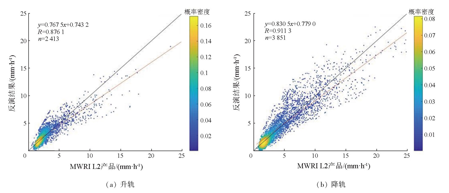
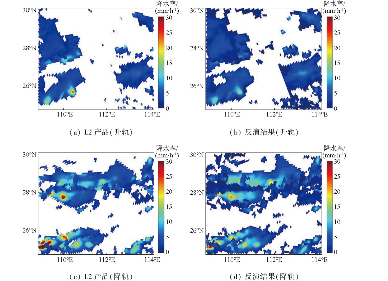
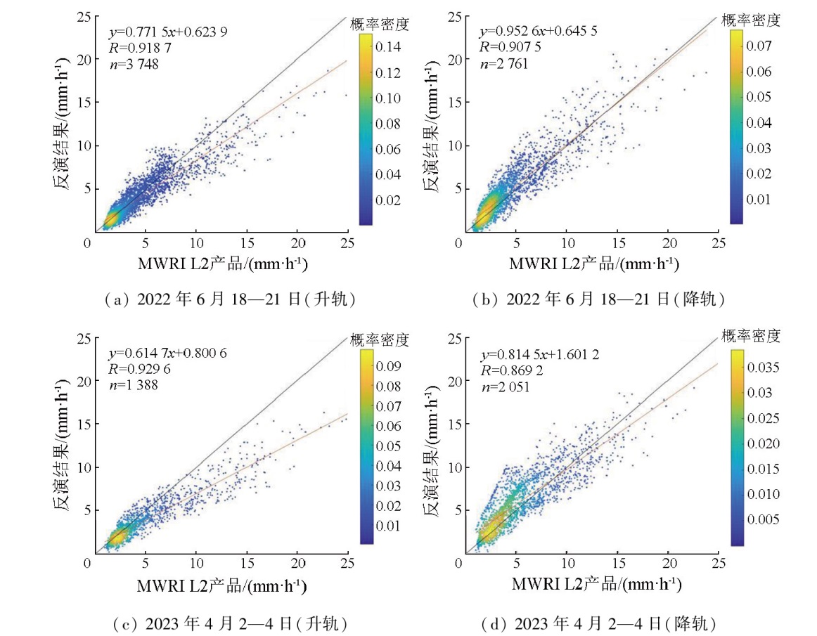
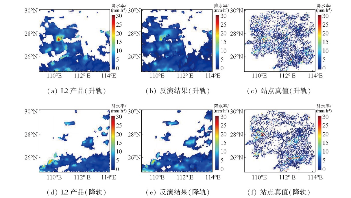
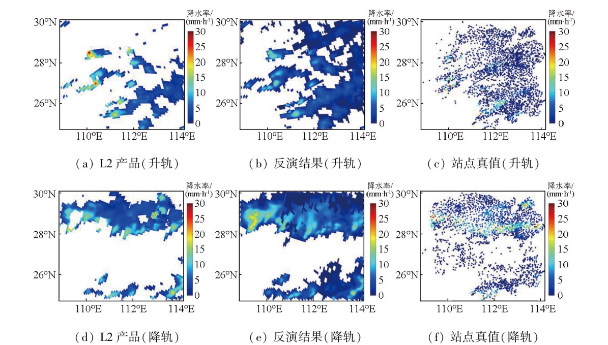
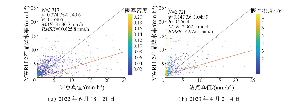
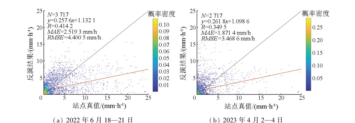
Abstract Using level-1 (L1) brightness temperature data from the Microwave Radiation Imager (MWRI) on board Fengyun-3D (FY-3D) satellite and the corresponding Level-2 (L2) precipitation products, this study established a precipitation rate inversion model for land surface heavy precipitation in Hunan Province based the polarization corrected temperature (PCT) and scatter index (SI). The proposed model was validated using individual examples. The results indicate that the precipitation rates retrieved from the L1 brightness temperature data of the FY-3D satellite were generally consistent with the results obtained from the L2 precipitation products. Compared to actual data, the retrieved precipitation rates were slightly higher in low precipitation areas but smaller in centers of high precipitation areas. The ascending orbit-based inversion model exhibited a correlation coefficient, mean absolute error (MAE), and root mean square error (RMSE) of 0.876 1, 0.771 1, and 1.151 4 mm/h, respectively. Conversely, the descending orbit-based inversion model presented a correlation coefficient, MAE, and RMSE of 0.911 3, 1.130 4, and 1.832 2 mm/h, respectively. The inversion results showed a larger precipitation distribution range than that of L2 products. Compared to the measurements at ground meteorological stations, the inversion model demonstrated higher accuracy than L2 products. This study successfully determined the distribution of land surface heavy precipitation in Hunan through inversion. The results of this study can provide a reference for investigating the relationship between microwave brightness temperature and precipitation and estimating land surface heavy precipitation.
|
| Keywords
FY-3D/MWRI
PCT-SI algorithm
heavy precipitation
precipitation rate inversion
|
|
|
|
Issue Date: 03 September 2025
|
|
|
| [1] |
李莹, 赵珊珊. 2001—2020年中国洪涝灾害损失与致灾危险性研究[J]. 气候变化研究进展, 2022, 18(2):154-165.
|
| [1] |
Li Y, Zhao S S. Floods losses and hazards in China from 2001 to 2020[J]. Climate Change Research, 2022, 18(2):154-165.
|
| [2] |
马铮, 王国复, 张颖娴. 1961—2019年中国区域连续性暴雨过程的危险性区划[J]. 气候变化研究进展, 2022, 18(2):142-153.
|
| [2] |
Ma Z, Wang G F, Zhang Y X. The risk regionalization of regional continuity rainstorm processes in China during 1961—2019[J]. Climate Change Research, 2022, 18(2):142-153.
|
| [3] |
李新同, 史岚, 陈多妍. 基于深度学习的闽浙赣GPM降水产品降尺度方法[J]. 自然资源遥感, 2023, 35(4):105-113.doi:10.6046/zrzyyg.2022270.
|
| [3] |
Li X T, Shi L, Chen D Y. A deep learning-based study on downscaling of GPM products in Fujian-Zhejiang-Jiangxi area[J]. Remote Sensing for Natural Resources, 2023, 35(4):105-113.doi:10.6046/zrzyyg.2022270.
|
| [4] |
Wei X C, Min M, Li J, et al. Characteristics of strong storms at the pre-convection stage from satellite microwave sounder observations[J]. Journal of Geophysical Research:Atmospheres, 2022, 127(22):e2022JD037216.
|
| [5] |
杜方洲, 石玉立, 盛夏. 基于深度学习的TRMM降水产品降尺度研究——以中国东北地区为例[J]. 国土资源遥感, 2020, 32(4):145-153.doi:10.6046/gtzyyg.2020.04.19.
|
| [5] |
Du F Z, Shi Y L, Sheng X. Research on downscaling of TRMM precipitation products based on deep learning:Exemplified by Northeast China[J]. Remote Sensing for Land and Resources, 2020, 32(4):145-153.doi:10.6046/gtzyyg.2020.04.19.
|
| [6] |
Hayden L, Liu C T. Differences in the diurnal variation of precipitation estimated by spaceborne radar,passive microwave radiometer,and IMERG[J]. Journal of Geophysical Research:Atmospheres, 2021, 126(9):e2020JD033020.
|
| [7] |
Bi M M, Zou X L. Comparison of cloud/rain band structures of Typhoon Muifa (2022) revealed in FY-3E MWHS-2 observations with all-sky simulations[J]. Journal of Geophysical Research:Atmospheres, 2023, 128(23):e2023JD039410.
|
| [8] |
何会中, 崔哲虎, 程明虎, 等. TRMM卫星及其数据产品应用[J]. 气象科技, 2004, 32(1):13-18.
|
| [8] |
He H Z, Cui Z H, Cheng M H, et al. TRMM satellite and application of its products[J]. Meteorological Science and Technology, 2004, 32(1):13-18.
|
| [9] |
唐国强, 万玮, 曾子悦, 等. 全球降水测量(GPM)计划及其最新进展综述[J]. 遥感技术与应用, 2015, 30(4) :607-615.
doi: 10.11873/j.issn.1004-0323.2015.4.0607
|
| [9] |
Tang G Q, Wan W, Zeng Z Y, et al. An overview of the global precipitation measurement (GPM) mission and it’s latest development[J]. Remote Sensing Technology and Application, 2015, 30(4):607-615.
|
| [10] |
谷松岩, 张鹏, 陈林, 等. 中国首颗降水测量卫星(风云三号G星)的探测能力概述与展望[J]. 暴雨灾害, 42(5):489-498.
|
| [10] |
Gu S Y, Zhang P, Chen L, et al. 2023. Overview and prospect of the detection capability of China’s first precipitation measurement satellite FY-3G[J]. Torrential Rain and Disasters, 2023, 42(5):489-498.
|
| [11] |
Spencer R W. A satellite passive 37-GHz scattering-based method for measuring oceanic rain rates[J]. Journal of Climate and Applied Meteorology, 1986, 25(6):754-766.
|
| [12] |
Spencer R W, Goodman H M, Hood R E. Precipitation retrieval over land and ocean with the SSM/I:Identification and characteristics of the scattering signal[J]. Journal of Atmospheric and Oceanic Technology, 1989, 6(2):254-273.
|
| [13] |
Cecil D J, Chronis T. Polarization-corrected temperatures for 10-,19-,37-,and 89-GHz passive microwave frequencies[J]. Journal of Applied Meteorology and Climatology, 2018, 57(10):2249-2265.
|
| [14] |
Grody N C. Classification of snow cover and precipitation using the special sensor microwave imager[J]. Journal of Geophysical Research:Atmospheres, 1991, 96(D4):7423-7435.
|
| [15] |
Ferraro R R, Grody N C, Marks G F. Effects of surface conditions on rain identification using the DMSP-SSM/I[J]. Remote Sensing Reviews, 1994, 11(1/2/3/4):195-209.
|
| [16] |
Ferraro R R, Smith E A, Berg W, et al. A screening methodology for passive microwave precipitation retrieval algorithms[J]. Journal of the Atmospheric Sciences, 1998, 55(9):1583-1600.
|
| [17] |
Liu G S, Curry J A. Retrieval of precipitation from satellite microwave measurement using both emission and scattering[J]. Journal of Geophysical Research:Atmospheres, 1992, 97(D9):9959-9974.
|
| [18] |
Li L, Zhu Y J, Zhao B L. Rainfall retrieval over land from satellite remote sensing (SSM/I)[J]. Chinese Science Bulletin, 1998, 43(22):1913-1917.
|
| [19] |
Zhao B L, Yao Z Y, Li W B, et al. Rainfall retrieval and flooding monitoring in China using TRMM microwave imager(TMI)[J]. Journal of the Meteorological Society of Japan, 2001, 79(1B):301-315.
|
| [20] |
李万彪, 陈勇, 朱元竞, 等. 利用热带降雨测量卫星的微波成像仪观测资料反演陆地降水[J]. 气象学报, 2001, 59(5):591-601.
|
| [20] |
Li W B, Chen Y, Zhu Y J, et al. Retrieval of rain over land by using TRMM/TMI measurements[J]. Acta Meteorologica Sinica, 2001, 59(5):591-601.
|
| [21] |
李世伟, 赖格英, 盛盈盈, 等. PCT-SI综合指数法反演陆面雨强[J]. 气象与环境科学, 2015, 38(2):102-107.
|
| [21] |
Li S W, Lai G Y, Sheng Y Y, et al. Refutation of rainfall density over land by PCT-SI[J]. Meteorological and Environmental Sciences, 2015, 38(2):102-107.
|
| [22] |
闵爱荣, 游然, 卢乃锰, 等. TRMM卫星微波成像仪资料的陆面降水反演[J]. 热带气象学报, 2008, 24(3):265-272.
|
| [22] |
Min A R, You R, Lu N M, et al. Retrieval of precipitation over land using TRMM microwave image[J]. Journal of Tropical Meteorology, 2008, 24(3):265-272.
|
| [23] |
邓欣柔, 吴莹. 基于GPM探测资料的台风降水水平结构分析[J]. 地球物理学进展, 2022, 37(5):1799-1806.
|
| [23] |
Deng X R, Wu Y. Analysis of horizontal precipitation structure of typhoon area based on GPM detection data[J]. Progress in Geophysics, 2022, 37(5):1799-1806.
|
| [24] |
闵爱荣, 张翠荣, 王晓芳. 基于微波成像仪资料反演陆面降水[J]. 气象科技, 2008, 36(4):495-498.
|
| [24] |
Min A R, Zhang C R, Wang X F. Retrieval of precipitation over land using microwave imagers[J]. Meteorological Science and Technology, 2008, 36(4):495-498.
|
|
Viewed |
|
|
|
Full text
|
|
|
|
|
Abstract
|
|
|
|
|
Cited |
|
|
|
|
| |
Shared |
|
|
|
|
| |
Discussed |
|
|
|
|
 2025,
Vol. 37
2025,
Vol. 37