|
|
|
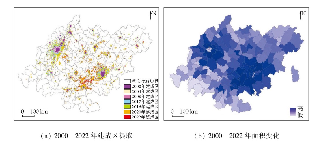
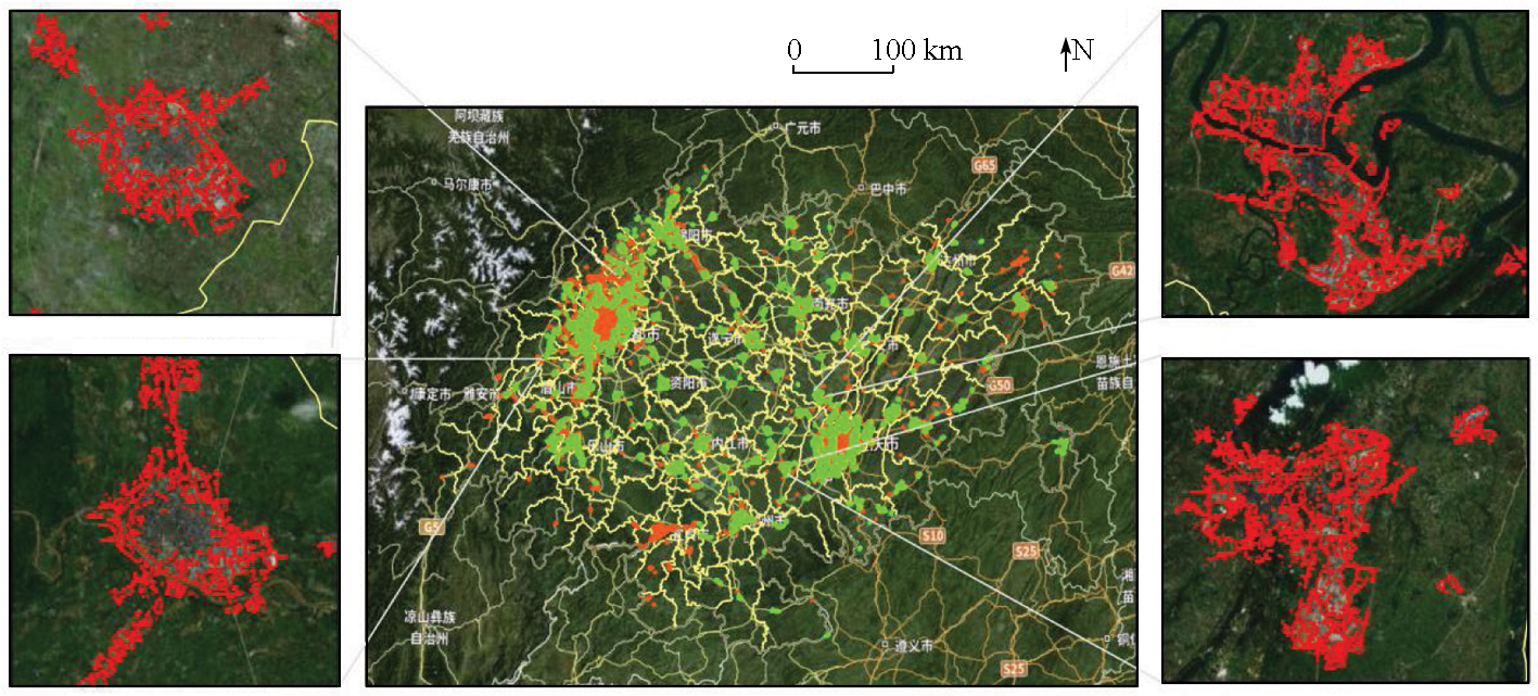
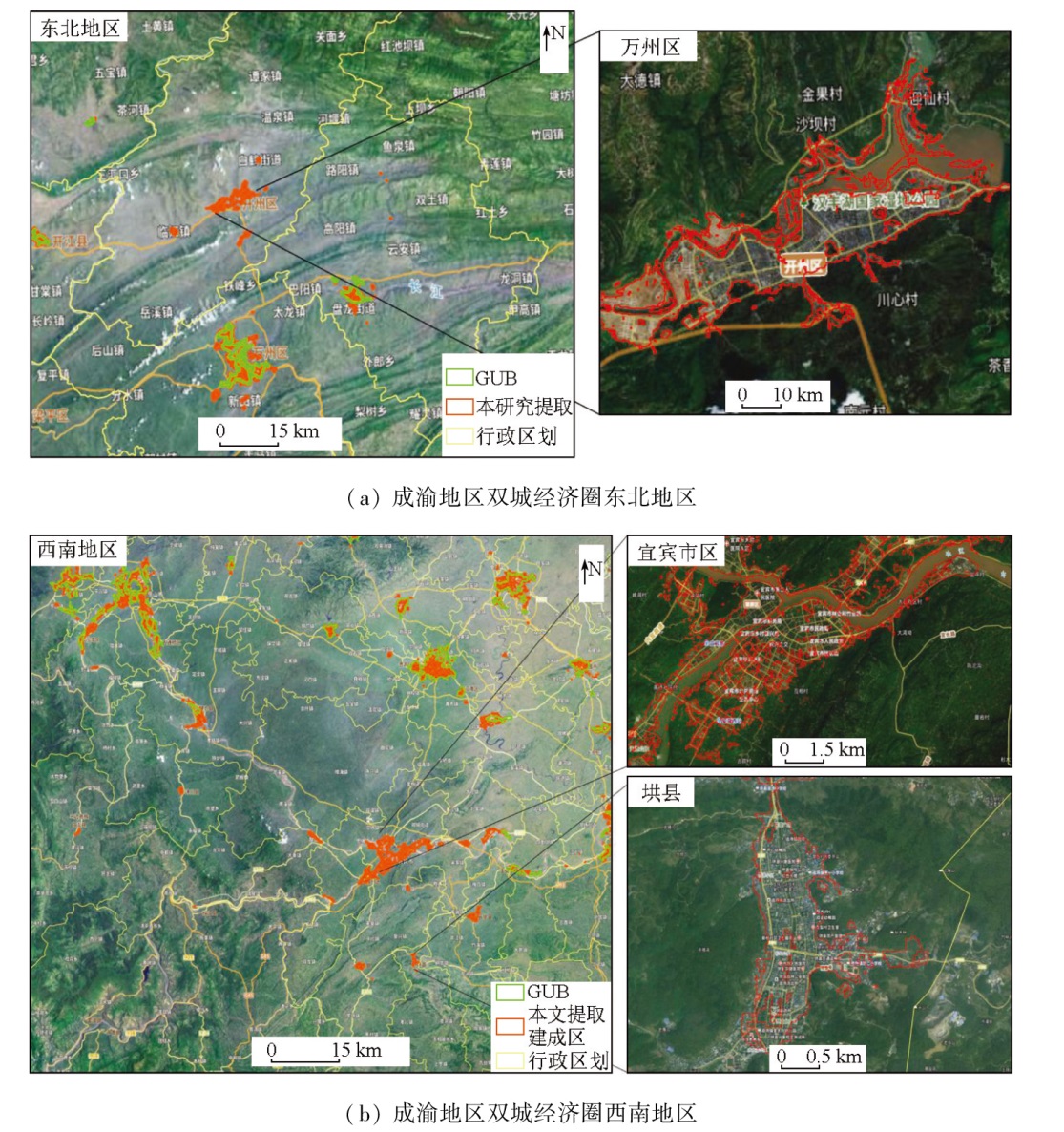
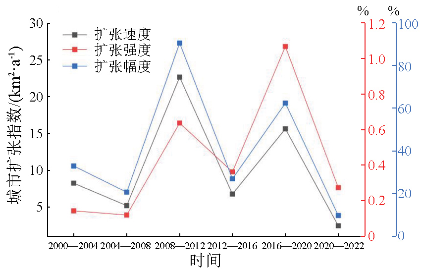
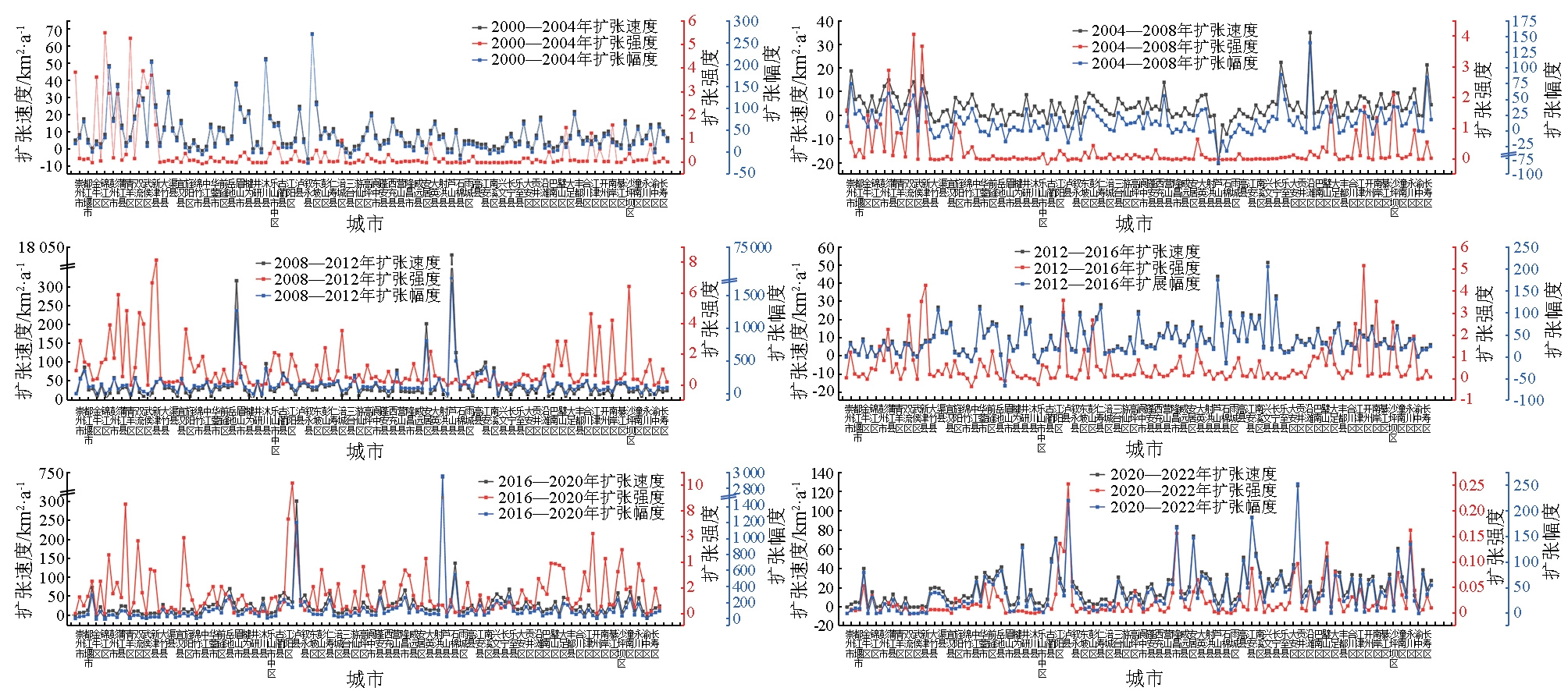
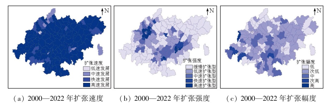
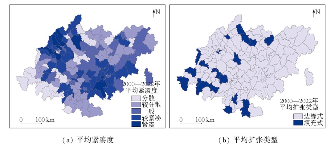
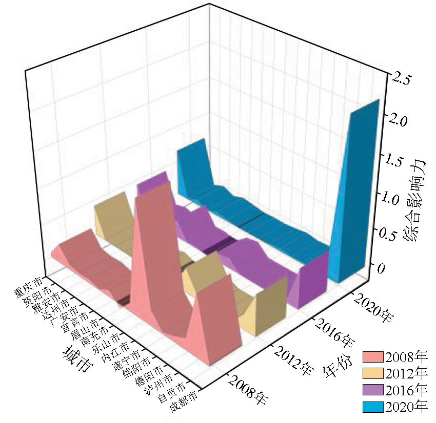
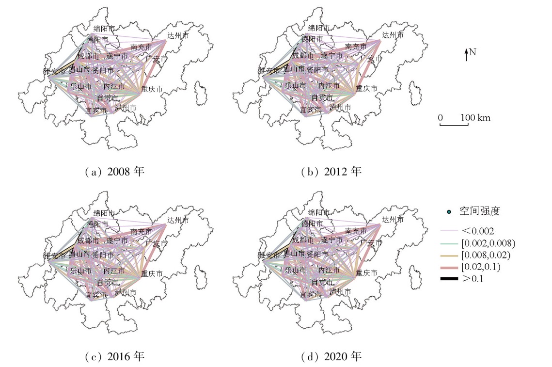
Abstract Understanding the characteristics of urban expansion and corresponding spatial changes serves as a prerequisite for optimizing urban spatial structure and resisting disorderly urban land expansion. This study focuses on the Chengdu-Chongqing economic circle. Using multi-source data fusion, this study extracted information on urban built-up areas from 2000 to 2020. From the aspects of urban expansion characteristics, spatial changes, and intercity spatial interaction intensity, this study analyzed the spatiotemporal evolution during urban expansion at both the regional and county scales. The results indicate that incorporating impervious surface information into multi-source data fusion improved the information extraction accuracy of built-up areas, achieving an overall classification accuracy of 98% and an average Kappa coefficient of 0.75. Urban expansion from 2000 to 2020 transitioned from low to medium-high speed and then to low speed. The dominant expansion type was edge expansion, accompanied by decreased spatial compactness. Within the Chengdu-Chongqing economic circle, the strongest spatial interaction intensity occurred between Chengdu and Chongqing. The urban spatial pattern exhibited a “dual cores with two wings” pattern, highlighting the pivotal role of Chengdu and Chongqing in driving the development of surrounding cities. These findings reveal the urban development patterns and spatial change characteristics within the Chengdu-Chongqing economic circle. They will facilitate the rational optimization of land use and territorial spatial patterns, promoting coordinated urban-rural development.
|
| Keywords
impervious surface
multi-source data
built-up area
urban expansion
spatiotemporal evolution
Chengdu-Chongqing twin-city economic Circle
|
|
|
|
Issue Date: 03 September 2025
|
|
|
| [1] |
张扬, 郑凤娇, 刘艳芳, 等. 基于POI与不透水表面指数的城市建成区提取[J]. 地理科学, 2022, 42(3):506-514.
doi: 10.13249/j.cnki.sgs.2022.03.015
|
| [1] |
Zhang Y, Zheng F J, Liu Y F, et al. Extracting urban built-up area based on impervious surface area and POI data[J]. Scientia Geographica Sinica, 2022, 42(3):506-514.
doi: 10.13249/j.cnki.sgs.2022.03.015
|
| [2] |
Li G, Fang C, Li Y, et al. Global impacts of future urban expansion on terrestrial vertebrate diversity[J]. Nature Communications, 2022, 13(1):1628.
doi: 10.1038/s41467-022-29324-2
pmid: 35338145
|
| [3] |
省委、省政府印发《美丽四川建设战略规划纲要(2022—2035年)》- 四川省人民政府网站[EB/OL].[2024-01-01]. https://www.sc.gov.cn/10462/10464/10797/2022/8/29/493ddce2b-17f47fb9a2dd951abe0cb96.shtml.
url: https://www.sc.gov.cn/10462/10464/10797/2022/8/29/493ddce2b-17f47fb9a2dd951abe0cb96.shtml
|
| [3] |
The Provincial Party Committee and the provincial government issued the Outline of the Strategic Plan for the Construction of Beautiful Sichuan (2022-2035) - Sichuan Provincial People’s Government Website [EB/OL].[2024-01-01]. https://www.sc.gov.cn/10462/10464/10797/2022/8/29/493ddce2b-17f47fb9a2dd951abe0cb96.shtml.
url: https://www.sc.gov.cn/10462/10464/10797/2022/8/29/493ddce2b-17f47fb9a2dd951abe0cb96.shtml
|
| [4] |
重庆市人民政府关于印发《重庆市自然资源保护和利用“十四五”规划(2021—2025年)》的通知_重庆市人民政府网[EB/OL].[2024-01-01]. https://www.cq.gov.cn/zwgk/zfxxgkml/szfwj/xzgfxwj/szf/202201/t20220124_10360585.html.
url: https://www.cq.gov.cn/zwgk/zfxxgkml/szfwj/xzgfxwj/szf/202201/t20220124_10360585.html
|
| [4] |
Notice of Chongqing Municipal People’s Government on Issuing the 14th Five-Year Plan for the Protection and Utilization of Natural Resources of Chongqing (2021-2025).[2024-01-01]. https://www.cq.gov.cn/zwgk/zfxxgkml/szfwj/xzgfxwj/szf/202201/t20220124_10360585.html.
url: https://www.cq.gov.cn/zwgk/zfxxgkml/szfwj/xzgfxwj/szf/202201/t20220124_10360585.html
|
| [5] |
陈星星. 基于夜间灯光数据的武汉市城镇用地扩张识别与空间分布特征研究[J]. 西南师范大学学报(自然科学版), 2019, 44(1):70-78.
|
| [5] |
Chen X X. Urban land expansion identification and spatial distribution characteristics of Wuhan city using DMSP/OLS nighttime light data[J]. Journal of Southwest China Normal University (Natural Science Edition), 2019, 44(1):70-78.
|
| [6] |
王敏, 李景保, 梁莉莉, 等. 基于夜间灯光数据的长沙市城市建成区提取结果对比分析[J]. 湖南师范大学自然科学学报, 2021, 44(4):45-52.
|
| [6] |
Wang M, Li J B, Liang L L, et al. Comprehensive analysis of the urban build-up area extraction based on night light data in Changsha[J]. Journal of Natural Science of Hunan Normal University, 2021, 44(4):45-52.
|
| [7] |
Xu P, Jin P, Cheng Q. Monitoring regional urban dynamics using DMSP/OLS nighttime light data in Zhejiang Province[J]. Mathematical Problems in Engineering, 2020, 2020:9652808.
|
| [8] |
刘清云, 范俊甫, 陈政, 等. 夜间灯光遥感数据一致性校正下成渝城市群扩张分析[J]. 测绘科学, 2022, 47(6):99-108.
|
| [8] |
Liu Q Y, Fan J F, Chen Z, et al. Expansion analysis of Chengdu-Chongqing urban agglomeration under nighttime light remote sensing data consistency correction[J]. Science of Surveying and Mapping, 2022, 47(6):99-108.
|
| [9] |
唐霞, 汤军, 李外宾, 等. 珞珈一号融合多源数据的建成区提取[J]. 遥感信息, 2023, 38(1):78-87.
|
| [9] |
Tang X, Tang J, Li W B, et al. Extraction of built-up area based on Luojia 1-01 combined with multi source data[J]. Remote Sensing Information, 2023, 38(1):78-87.
|
| [10] |
尹旭, 魏慧, 李裕瑞. 基于不透水面的中国县城建成区识别与时空演变研究[J]. 地理研究, 2023, 42(6):1492-1505.
doi: 10.11821/dlyj020221372
|
| [10] |
Yin X, Wei H, Li Y R. Identification and spatio-temporal variation of county towns’built-up area of China based on impervious surface dataset[J]. Geographical Research, 2023, 42(6):1492-1505.
|
| [11] |
李广东, 戚伟. 中国建设用地扩张对景观格局演化的影响[J]. 地理学报, 2019, 74(12):2572-2591.
doi: 10.11821/dlxb201912011
|
| [11] |
Li G D, Qi W. Impacts of construction land expansion on landscape pattern evolution in China[J]. Acta Geographica Sinica, 2019, 74(12):2572-2591.
doi: 10.11821/dlxb201912011
|
| [12] |
张亚萍, 张平, 孙丹峰, 等. 成渝城市群城市建设用地扩张格局及规模体系分析[J]. 测绘通报, 2020(7):103-107.
doi: 10.13474/j.cnki.11-2246.2020.0223
|
| [12] |
Zhang Y P, Zhang P, Sun D F, et al. Analysis of urban construction land expansion pattern and scale system in Chengdu-Chongqing urban agglomeration[J]. Bulletin of Surveying and Mapping, 2020(7):103-107.
doi: 10.13474/j.cnki.11-2246.2020.0223
|
| [13] |
王亚楠, 苏明明, 王玉萍. 黄河流域城市扩张时空特征与区域差异——基于资源型城市与非资源型城市的对比[J]. 中国农业资源与区划, 2024, 45(6):223-233.
|
| [13] |
Wang Y N, Su M M, Wang Y P. Spatial and temporal characteristics and regional differences of urban expansion in the Yellow River Basin:Based on compartive analysis of resource-based and non-resource-based cities[J]. Agricultural resources and Regionalization in China, 2024, 45(6):223-233.
|
| [14] |
林钦贤, 林以恒, 真诗泳, 等. 建设用地扩张规律及其与道路网络的空间自相关分析——以福州市为例[J]. 科学技术与工程, 2023, 23(7):3001-3010.
|
| [14] |
Lin Q X, Lin Y H, Zhen S Y, et al. Expansion law of construction land and its spatial autocorrelation analysis with road network:Taking Fuzhou as an example[J]. Science Technology and Engineering, 2023, 23(7):3001-3010.
|
| [15] |
Huang X, Li J, Yang J, et al. 30 m global impervious surface area dynamics and urban expansion pattern observed by Landsat satellites:From 1972 to 2019[J]. Science China Earth Sciences, 2021, 64(11):1922-1933.
|
| [16] |
Gong P, Li X, Wang J, et al. Annual maps of global artificial impervious area (GAIA) between 1985 and 2018[J]. Remote Sensing of Environment, 2020, 236:111510.
|
| [17] |
Li X, Zhou Y, Zhao M, et al. A harmonized global nighttime light dataset 1992-2018[J]. Scientific Data, 2020, 7(1):168.
doi: 10.1038/s41597-020-0510-y
pmid: 32499523
|
| [18] |
Li X, Gong P, Zhou Y, et al. Mapping global urban boundaries from the global artificial impervious area (GAIA) data[J]. Environmental Research Letters, 2020, 15(9):094044.
|
| [19] |
许泽宁, 高晓路. 基于电子地图兴趣点的城市建成区边界识别方法[J]. 地理学报, 2016, 71(6):928-939.
doi: 10.11821/dlxb201606003
|
| [19] |
Xu Z N, Gao X L. A novel method for identifying the boundary of urban built-up areas with POI data[J]. Acta Geographica Sinica, 2016, 71(6):928-939.
doi: 10.11821/dlxb201606003
|
| [20] |
郑洪晗, 桂志鹏, 栗法, 等. 夜间灯光数据和兴趣点数据结合的建成区提取方法[J]. 地理与地理信息科学, 2019, 35(2):25-32.
|
| [20] |
Zheng H H, Gui Z P, Li F, et al. Urban built-up area extraction method based on nighttime light images and point of interest data[J]. Geography and Geo-Information Science, 2019, 35(2):25-32.
|
| [21] |
马歆, 和舒敏, 黄婷婷, 等. 城市用地扩张的时空格局特征及驱动因素分析——以中原城市群为例[J]. 生态经济, 2020, 36(3):105-111,167.
|
| [21] |
Ma X, He S M, Huang T T, et al. Analysis of spatial-temporal pattern characteristics and driving factors of urban land expansion:Taking central plains city cluster as an example[J]. Ecological Economy, 2020, 36(3):105-111,167.
|
| [22] |
张娜, 张会霞, 李艾琴. 基于夜间灯光影像的太原市城市扩张特征及驱动力分析[J]. 测绘通报, 2022(11):79-83,105.
doi: 10.13474/j.cnki.11-2246.2022.0329
|
| [22] |
Zhang N, Zhang H X, Li A Q. Analysis of urban expansion characteristics and driving force analysis of Taiyuan City based on night light images[J]. Bulletin of Surveying and Mapping, 2022(11):79-83,105.
doi: 10.13474/j.cnki.11-2246.2022.0329
|
| [23] |
胡苗苗, 闫庆武, 李建辉. 基于DMSP/OLS和NPP/VIIRS夜光影像的中原城市群城市扩张的时空演变及驱动力分析[J]. 自然资源遥感, 2024(1):189-199.doi:10.6046/zrzyyg.2022410.
|
| [23] |
Hu M M, Yan Q W, Li J H. Analyzing the spatio-temporal evolution of urban expansion in the central plains urban agglomeration and its driving force based on DMSP/OLS and NPP/VIIRS nighttime light images[J]. Remote Sensing for Natural Resources, 2024(1):189-199.doi:10.6046/zrzyyg.2022410.
|
| [24] |
俞艳, 童艳, 胡珊珊, 等. 武汉城市圈城市空间相互作用时空演变分析[J]. 长江流域资源与环境, 2017, 26(11):1784-1794.
|
| [24] |
Yu Y, Tong Y, Hu S S, et al. Spatial-temporal evolution of spatial interaction among cities of Wuhan metropolitan area[J]. Resources and Environment in the Yangtze Basin, 2017, 26(11):1784-1794.
|
| [25] |
赵东卉, 刘勇, 刘秀华. 基于引力模型的多中心城市地价空间结构分析——以重庆市为例[J]. 西南大学学报(自然科学版), 2017, 39(7):130-135.
|
| [25] |
Zhao D H, Liu Y, Liu X H. A gravity model-based analysis of the spatial structure of land price in polycentric cities:A case study of Chongqing[J]. Journal of Southwest University (Natural Science Edition), 2017, 39(7):130-135.
|
| [26] |
李春, 王金柱, 刘勇, 等. 成渝地区双城经济圈的城市扩张时空演变特征[J]. 现代城市研究, 2023(11):34-41,50.
|
| [26] |
Li C, Wang J Z, Liu Y, et al. Spatial-temporal evolution characteristics of urban expansion in Chengdu-Chongqing twin-city economic circle[J]. Modern Urban Research, 2023(11):34-41,50.
|
| [27] |
刘小波, 王海力, 刘颖, 等. 成渝城市群中心城市空间扩展特征及驱动机制[J]. 重庆师范大学学报(自然科学版), 2024, 41(3):121-132.
|
| [27] |
Liu X B, Wang H L, Liu Y, et al. Characteristics and driving mechanism of central city spatial expansion pattern of Chengdu-Chongqing urban agglomeration[J]. Journal of Chongqing Normal University (Natural Science Edition), 2024, 41(3):121-132.
|
|
Viewed |
|
|
|
Full text
|
|
|
|
|
Abstract
|
|
|
|
|
Cited |
|
|
|
|
| |
Shared |
|
|
|
|
| |
Discussed |
|
|
|
|
 2025,
Vol. 37
2025,
Vol. 37
 ), ZHU Shirou1(