|
|
 |
|

|
|
|
Analysis of the spatiotemporal variation characteristics of regional multi-scale land subsidence |
WANG Qin1,2( ), GONG Huili1,2(), CHEN Beibei1,2, ZHOU Chaofan1,2, ZHU Lin1,2 ), GONG Huili1,2(), CHEN Beibei1,2, ZHOU Chaofan1,2, ZHU Lin1,2 |
1. School of Resources, Environment and Tourism, Capital Normal University, Beijing 100048, China
2. Key Laboratory of Land Subsidence Mechanism and Prevention, Ministry of Education, Capital Normal University, Beijing 100048, China |
|
|
|
|
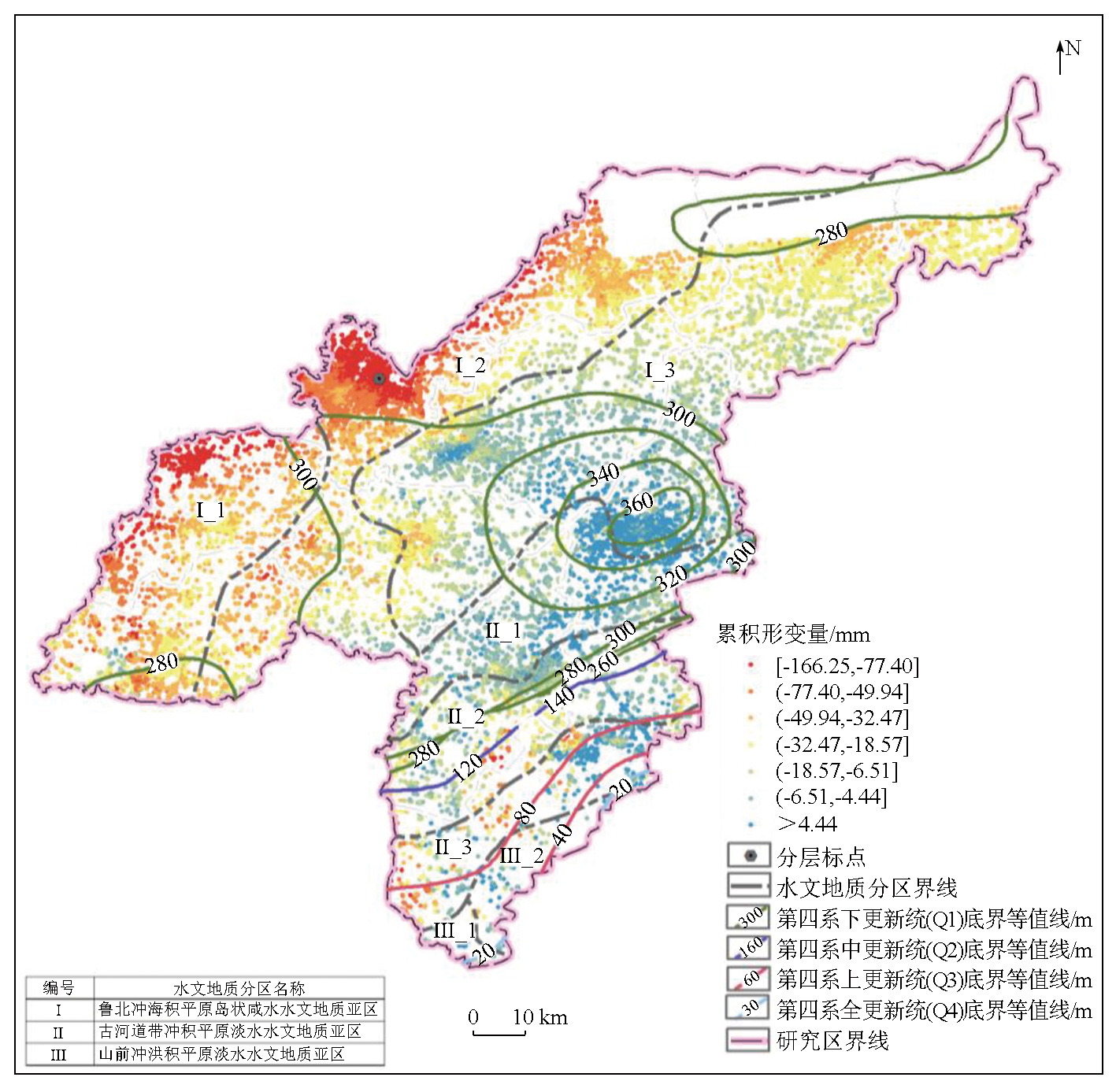
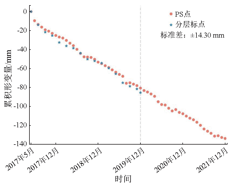
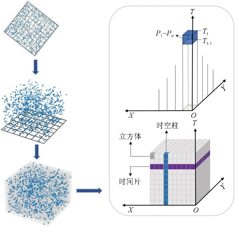
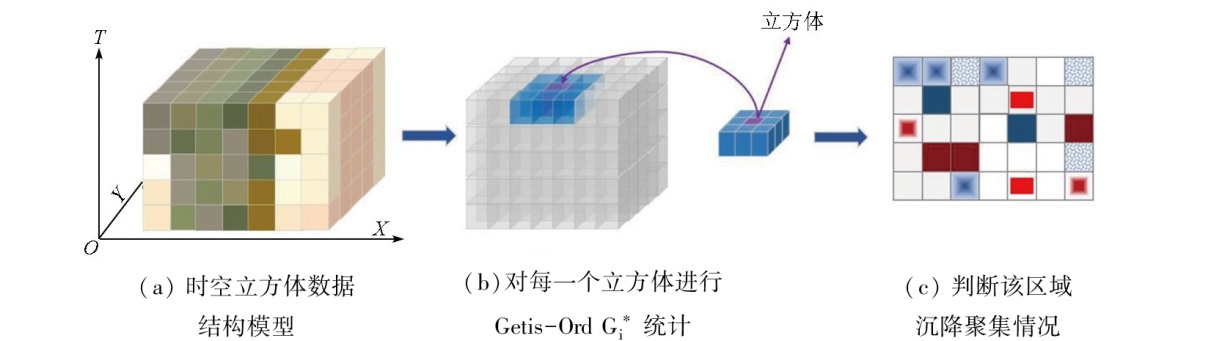
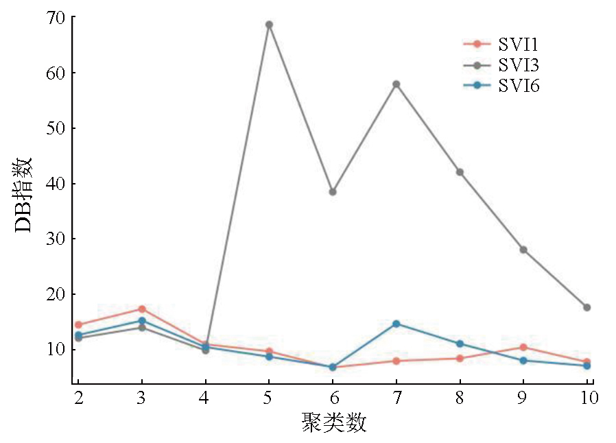
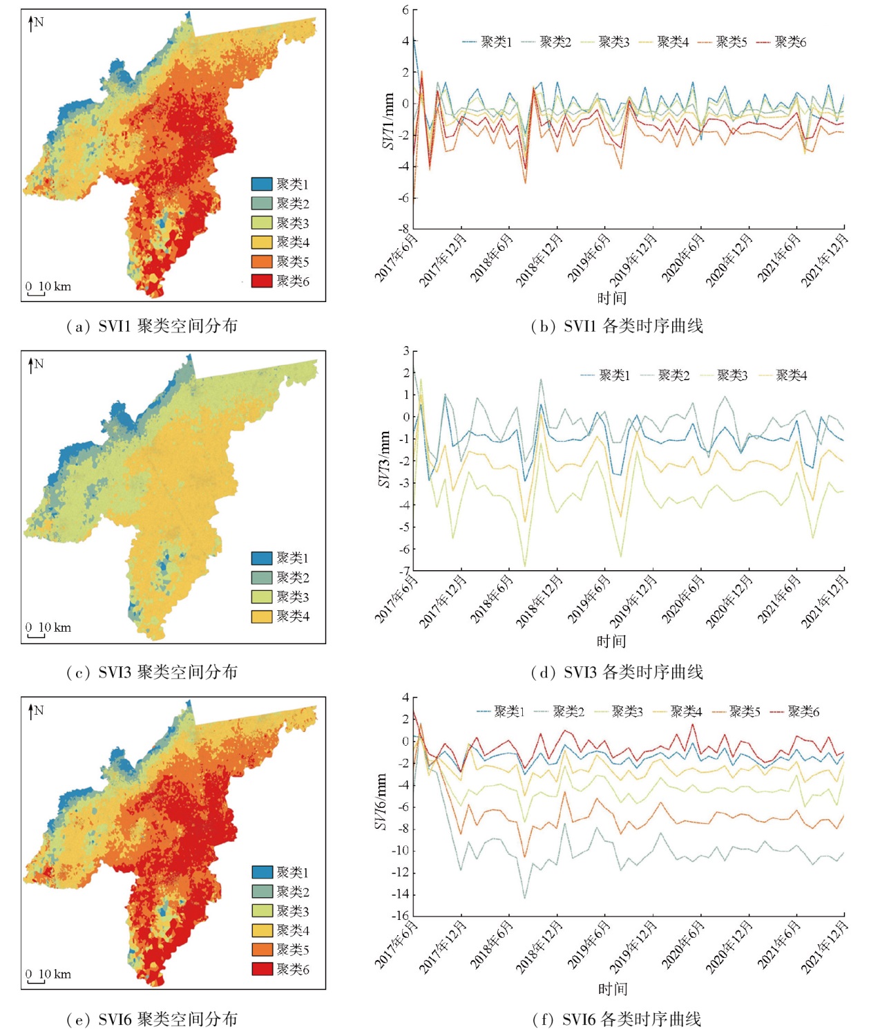
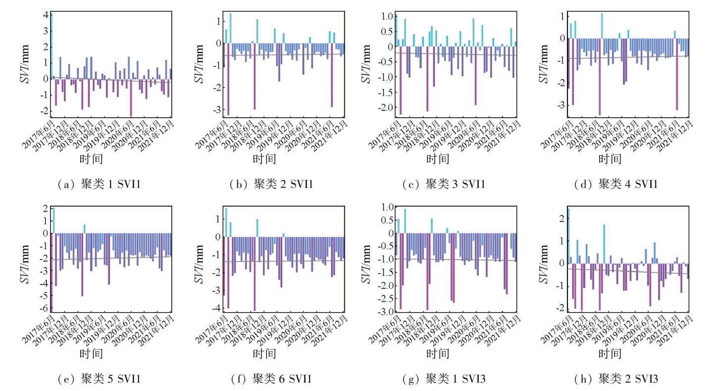
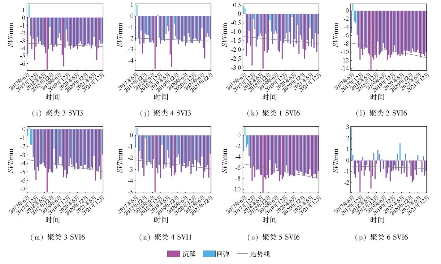
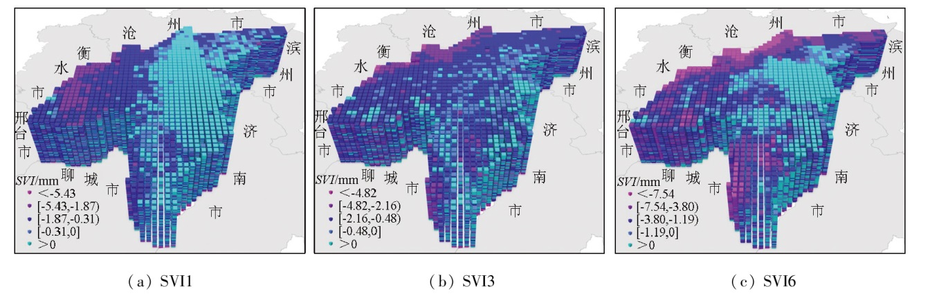
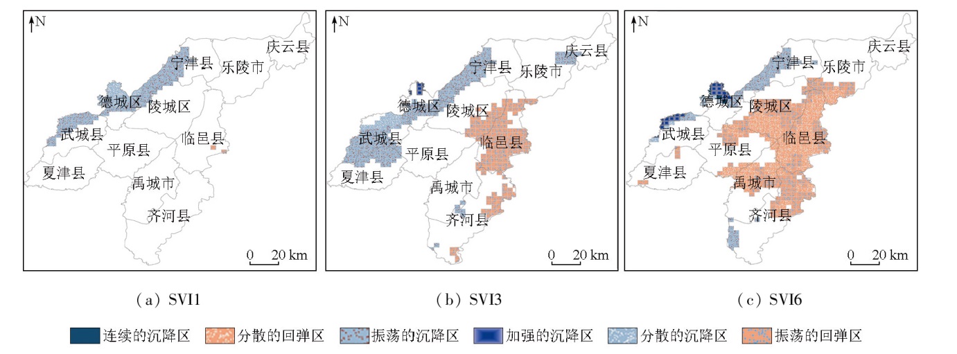
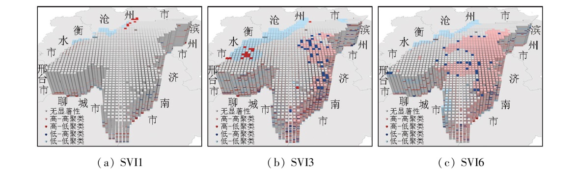
Abstract Rapid and uneven land subsidence severely threatens human life and production activities. Understanding the spatiotemporal evolutionary patterns of land subsidence is crucial for the precise prevention and control of geological disasters. Employing the persistent scatterer interferometric synthetic aperture Radar (PS-InSAR) technology, this study obtained the information of monthly surface deformation in Dezhou City to calculate the multi-scale subsidence vulnerability indices (SVI). Combining time series cluster analysis, space-time cube, spatiotemporal hot spot analysis, and spatiotemporal outlier analysis, this study explored the spatiotemporal distribution characteristics of multi-scale SVI in Dezhou City from July 2017 to December 2021. The time series cluster analysis reveals inconspicuous trend clustering on a monthly scale, and significant clustering characteristics on quarterly and semi-annual scales, with large subsidence fluctuations on a semi-annual scale. The space-time cube model presents poor continuity of SVI and subtle subsidence variations on a monthly scale. In contrast, the subsidence on quarterly and semi-annual scales exhibited relatively close occurrence time, showing a significant pattern of subsidence from March to August and rebound from September to February of the ensuing year. The spatiotemporal hot spot analysis of SVI in Dezhou City for 54 months shows that enhanced and continuous subsidences occurred primarily in the northwest of Wucheng County and Decheng District. Oscillatory subsidence and rebound occurred principally in Linyi, Yucheng, and Qihe counties in the southeast. The local outlier analysis of multi-scale SVI shows nonsignificant subsidence characteristics on a monthly scale but similar subsidence conditions on quarterly and semi-annual scales. Seasonal subsidence and semi-annual subsidence related to crop growth in Linyi and Qihe counties gradually weakened or even rebounded. Notably, the high-high clustering range on a semi-annual scale was broader, accompanied by a more significant rebound.
|
| Keywords
land subsidence
multi-scale
increment
spatiotemporal variation characteristics
persistent scatterer interferometric synthetic aperture Radar (PS-InSAR)
|
|
|
|
Issue Date: 03 September 2025
|
|
|
| [1] |
周飞飞. 《全国地面沉降防治规划(2011—2020年)》解读——访国土资源部地质环境司副司长陶庆法[J]. 中国应急管理, 2012(3):56-59.
|
| [1] |
Zhou F F. Interpretation of national land subsidence prevention and control plan (2011—2020):Interview with Tao Qingfa,deputy director of geology and environment department of ministry of land and resources[J]. China Emergency Management, 2012(3):56-59.
|
| [2] |
史珉, 宫辉力, 陈蓓蓓, 等. Sentinel-1A京津冀平原区2016—2018年地面沉降InSAR监测[J]. 自然资源遥感, 2021, 33(4):55-63.doi:10.6046/zrzyyg.2020341.
|
| [2] |
Shi M, Gong H L, Chen B B, et al. Monitoring of land subsidence in Beijing-Tianjin-Hebei Plain during 2016—2018 based on InSAR and sentinel-1A data[J]. Remote Sensing for Natural Resources, 2021, 33(4):55-63.doi:10.6046/zrzyyg.2020341.
|
| [3] |
于文, 宫辉力, 陈蓓蓓, 等. 北京东部平原区地面沉降时空演化特征及预测[J]. 自然资源遥感, 2022, 34(4):183-193.doi:10.6046/zrzyyg.2021390.
|
| [3] |
Yu W, Gong H L, Chen B B, et al. Spatial-temporal evolution characteristics and prediction of land subsidence in the eastern plain of Beijing[J]. Remote Sensing for Natural Resources, 2022, 34(4):183-193.doi:10.6046/zrzyyg.2021390.
|
| [4] |
Wang J F, Wang Y, Zhang J, et al. Spatiotemporal transmission and determinants of typhoid and paratyphoid fever in Hongta District,Yunnan Province,China[J]. PLOS Neglected Tropical Diseases, 2013, 7(3):e2112.
|
| [5] |
王劲峰, 葛咏, 李连发, 等. 地理学时空数据分析方法[J]. 地理学报, 2014, 69(9):1326-1345.
doi: 10.11821/dlxb201409007
|
| [5] |
Wang J F, Ge Y, Li L F, et al. Spatiotemporal data analysis in geography[J]. Acta Geographica Sinica, 2014, 69(9):1326-1345.
doi: 10.11821/dlxb201409007
|
| [6] |
贾超, 张少鹏, 孙晓晓, 等. 鲁西北平原地下水开采与地面沉降的相关性[J]. 中国科技论文, 2021, 16(2):173-180.
|
| [6] |
Jia C, Zhang S P, Sun X X, et al. Correlation between groundwater exploitation and land subsidence in northwest plain of Shandong Province[J]. China Sciencepaper, 2021, 16(2):173-180.
|
| [7] |
周梦杰, 白紫月, 高兴, 等. 海口市网约车乘客出行时空模式挖掘[J]. 测绘科学, 2021, 46(10):177-184,218.
|
| [7] |
Zhou M J, Bai Z Y, Gao X, et al. Excavation of the spatio-temporal pattern of passenger travel in Haikou City[J]. Science of Surveying and Mapping, 2021, 46(10):177-184,218.
|
| [8] |
朱艳丽, 靖常峰, 伏家云, 等. 时空立方体的抢劫案件时空特征挖掘与分析[J]. 测绘科学, 2019, 44(9):132-138,145.
|
| [8] |
Zhu Y L, Jing C F, Fu J Y, et al. Analysis of space-time pattern of robbery crime based on space-time cube[J]. Science of Surveying and Mapping, 2019, 44(9):132-138,145.
|
| [9] |
洪安东. 基于时空立方体的交通拥堵点时空模式挖掘与分析[D]. 成都: 西南交通大学, 2017.
|
| [9] |
Hong A D. Spatio-temporal pattern mining and analysis of traffic congestion points based on spatio-temporal cube[D]. Chengdu: Southwest Jiaotong University, 2017.
|
| [10] |
廖一兰, 王劲峰, 杨维中, 等. 传染病多维度聚集性探测方法[J]. 地理学报, 2012, 67(4):435-443.
doi: 10.11821/xb201204001
|
| [10] |
Liao Y L, Wang J F, Yang W Z, et al. A study on detecting multi-dimensional clusters of infectious diseases[J]. Acta Geographica Sinica, 2012, 67(4):435-443.
doi: 10.11821/xb201204001
|
| [11] |
黄波, 赵涌泉. 多源卫星遥感影像时空融合研究的现状及展望[J]. 测绘学报, 2017, 46(10):1492-1499.
doi: 10.11947/j.AGCS.2017.20170376
|
| [11] |
Huang B, Zhao Y Q. Research status and prospect of spatiotemporal fusion of multi-source satellite remote sensing imagery[J]. Acta Geodaetica et Cartographica Sinica, 2017, 46(10):1492-1499.
doi: 10.11947/j.AGCS.2017.20170376
|
| [12] |
陈云天. 基于时空立方体的南昌市房价时空分布特征分析[J]. 江西科学, 2019, 37(3):371-377.
|
| [12] |
Chen Y T. An analysis of spatial-temporal distribution characteristics of housing prices in Nanchang based on space-time cube[J]. Jiangxi Science, 2019, 37(3):371-377.
|
| [13] |
Davies D L, Bouldin D W. A cluster separation measure[J]. IEEE Transactions on Pattern Analysis and Machine Intelligence, 1979, PAMI-1(2):224-227.
|
| [14] |
赵玉麒. 山东德州开采地下水导致地面沉降的研究[D]. 长春: 吉林大学, 2016.
|
| [14] |
Zhao Y Q. Research of the ground subsidence disaster caused by groundwater exploitation in Dezhou region[D]. Changchun: Jilin University, 2016.
|
| [15] |
王明珠, 万军伟. 山东省德州市地面沉降控沉分析及建议[J]. 中国地质调查, 2020, 7(3):96-103.
|
| [15] |
Wang M Z, Wan J W. Analysis and suggestions on land subsidence control in Dezhou of Shandong Province[J]. Geological Survey of China, 2020, 7(3):96-103.
|
| [16] |
徐军祥, 赵书泉, 康凤新, 等. 山东省地质环境问题研究[M]. 北京: 地质出版社, 2010: 19-20.
|
| [16] |
Xu J X, Zhao S Q, Kang F X, et al. Study on the geological environment problems in Shandong Province[M]. Beijing: Geological Publishing House, 2010: 19-20.
|
| [17] |
Ferretti A, Prati C, Rocca F. Permanent scatterers in SAR interfe-rometry[J]. IEEE Transactions on Geoscience and Remote Sensing, 2001, 39(1):8-20.
|
| [18] |
邓敏, 刘启亮, 李光强, 等. 空间聚类分析及应用[M]. 北京: 科学出版社, 2011: 75-76.
|
| [18] |
Deng M, Liu Q L, Li G Q, et al. Spatial clustering analysis and its application[M]. Beijing: Science Press, 2011: 75-76.
|
| [19] |
Estivill-Castro V, Lee I. Multi-level clustering and its visualization for exploratory spatial analysis[J]. GeoInformatica, 2002, 6(2):123-152.
|
| [20] |
杨学习, 石岩, 邓敏, 等. 一种基于多层次专题属性约束的空间异常探测方法[J]. 武汉大学学报(信息科学版), 2016, 41(6):810-817.
|
| [20] |
Yang X X, Shi Y, Deng M, et al. A new method of spatial outlier detection by considering multi-level thematic attribute constraints[J]. Geomatics and Information Science of Wuhan University, 2016, 41(6):810-817.
|
| [21] |
刘青豪, 刘慧敏, 张永红, 等. 顾及空间异质性的大范围地面沉降时空预测[J]. 遥感学报, 2022, 26(7):1315-1325.
|
| [21] |
Liu Q H, Liu H M, Zhang Y H, et al. A spatio-temporal prediction method of large-scale ground subsidence considering spatial hete-rogeneity[J]. National Remote Sensing Bulletin, 2022, 26(7):1315-1325.
|
| [22] |
张棋, 许德合, 丁严. 基于SPEI和时空立方体的中国近40年干旱时空模式挖掘[J]. 干旱地区农业研究, 2021, 39(3):194-201.
|
| [22] |
Zhang Q, Xu D H, Ding Y. Spatio-temporal pattern mining of the last 40 years of drought in China based on SPEI index and spatio-temporal cube[J]. Agricultural Research in the Arid Areas, 2021, 39(3):194-201.
|
| [23] |
Getis A, Ord J K. The analysis of spatial association by use of distance statistics[J]. Geographical Analysis, 1992, 24(3):189-206.
|
| [24] |
阳中磊. 基于InSAR技术的城市沉降监测及时空分析[D]. 徐州: 中国矿业大学, 2023.
|
| [24] |
Yang Z L. Urban subsidence monitoring and spatiotemporal analysis based on InSAR[D]. Xuzhou: China University of Mining and Technology, 2023.
|
| [25] |
Sharma S, Saha A K. Statistical analysis of rainfall trends over Damodar River basin,India[J]. Arabian Journal of Geosciences, 2017, 10(15):319.
|
| [26] |
郭海朋, 李文鹏, 王丽亚, 等. 华北平原地下水位驱动下的地面沉降现状与研究展望[J]. 水文地质工程地质, 2021, 48(3):162-171.
|
| [26] |
Guo H P, Li W P, Wang L Y, et al. Present situation and research prospects of the land subsidence driven by groundwater levels in the North China Plain[J]. Hydrogeology & Engineering Geology, 2021, 48(3):162-171.
|
|
Viewed |
|
|
|
Full text
|
|
|
|
|
Abstract
|
|
|
|
|
Cited |
|
|
|
|
| |
Shared |
|
|
|
|
| |
Discussed |
|
|
|
|
 2025,
Vol. 37
2025,
Vol. 37