|
|
|
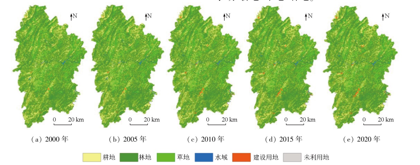
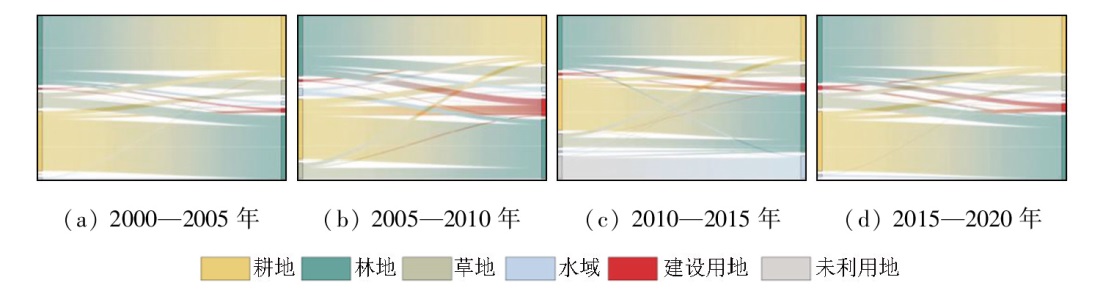
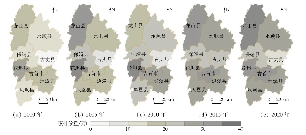
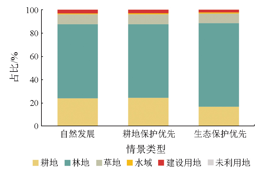
Abstract Investigating land-use-related carbon emissions (LCE) plays a vital role in achieving goals of peak carbon dioxide emissions and carbon neutrality (also referred to as the “dual carbon” goals). Research on the changes and prediction of LCE in Xiangxi Tujia and Miao Autonomous Prefecture (also referred to as the Xiangxi Prefecture) can provide a theoretical reference for the region to develop policies on the achievement of the “dual carbon” goals and for local balanced development and protection. Based on five sets of land use data from 2000 to 2020, this study analyzed the land use conditions and the spatiotemporal evolution of historical carbon emissions in Xiangxi Prefecture. The factors influencing LCE were determined using a decoupling model and a logarithmic mean Divisia index (LMDI) model. Furthermore, three land use scenarios were established: natural development, priority of cultivated land protection, and ecological protection priority. Using these scenarios, this study predicted the land use and carbon emissions in Xiangxi Prefecture in 2030. The results indicate that forest land represents the dominant land use type in Xiangxi Prefecture. Regarding land use transition, the period from 2000 to 2020 witnessed a significant increase in construction land, which encroached into substantial areas of forest land and cultivated land. Concurrently, water bodies and grassland decreased in area, being converted into forest land and cultivated land. From the perspective of carbon emissions, land use in the region exhibited a transformation from carbon sinks to carbon sources in general. During the 20-year span, the total LCE continued to increase. Construction land was identified as the primary land type as a carbon source, while forest land was the main land type as a carbon sink. Within the 20 years, carbon emissions decreased only in Huayuan County but increased in all other counties and cities. After 2010, the original regions with elevated carbon emissions showed a decrease in carbon emissions, while other regions witnessed growing carbon emissions to varying degrees. These regional changes in carbon emissions were largely attributed to the increased carbon emissions from construction land. Xiangxi Prefecture maintained a weak decoupling effect generally, with counties and cities fluctuating between weak decoupling and strong decoupling states. The economic output effect and energy efficiency effect served as the primary factors influencing carbon emissions. The overall land pattern remained relatively stable across the three scenarios. The carbon emissions of the three scenarios increased in the order of ecological protection priority, natural development, and priority of cultivated land protection. In the future, construction land will still represent the dominant factor causing overall changes in carbon emissions, while forest land will remain as the primary carbon sink.
|
| Keywords
land use
carbon emission
logarithmic mean Divisia index (LMDI)
CA-Markov
scenario forecasting
Xiangxi Tujia and Miao Autonomous Prefecture
|
|
|
|
Issue Date: 03 September 2025
|
|
|
| [1] |
周嘉, 王钰萱, 刘学荣, 等. 基于土地利用变化的中国省域碳排放时空差异及碳补偿研究[J]. 地理科学, 2019, 39(12):1955-1961.
doi: 10.13249/j.cnki.sgs.2019.12.014
|
| [1] |
Zhou J, Wang Y X, Liu X R, et al. Spatial temporal differences of carbon emissions and carbon compensation in China based on land use change[J]. Scientia Geographica Sinica, 2019, 39(12):1955-1961.
doi: 10.13249/j.cnki.sgs.2019.12.014
|
| [2] |
Houghton R A. The annual net flux of carbon to the atmosphere from changes in land use 1850—1990[J]. Tellus B:Chemical and Physical Meteorology, 1999, 51(2):298.
|
| [3] |
Houghton R A, Hackler J L. Sources and sinks of carbon from land-use change in China[J]. Global Biogeochemical Cycles, 2003, 17(2):1-9.
|
| [4] |
冯薇, 赵荣钦, 谢志祥, 等. 碳中和目标下土地利用碳排放效率及其时空格局——以黄河流域72个地级市为例[J]. 中国土地科学, 2023, 37(1):102-113.
|
| [4] |
Feng W, Zhao R Q, Xie Z X, et al. Land use carbon emission efficiency and its spatial-temporal pattern under carbon neutral target:A case study of 72 cities in the Yellow River Basin[J]. China Land Science, 2023, 37(1):102-113.
|
| [5] |
彭文甫, 周介铭, 徐新良, 等. 基于土地利用变化的四川省碳排放与碳足迹效应及时空格局[J]. 生态学报, 2016, 36(22):7244-7259.
|
| [5] |
Peng W F, Zhou J M, Xu X L, et al. Effect of land use changes on the temporal and spatial patterns of carbon emissions and carbon footprints in the Sichuan Province of Western China,from 1990 to 2010[J]. Acta Ecologica Sinica, 2016, 36(22):7244-7259.
|
| [6] |
王奕淇, 甄雯青. 基于主体功能区的碳收支时空分异和碳补偿分区:以黄河流域县域为例[J]. 环境科学, 2024, 45(9):5015-5026.
|
| [6] |
Wang Y Q, Zhen W Q. Spatiotemporal differentiation of carbon budget and carbon compensation zoning based on the plan for major function-oriented zones:A case study of counties in the Yellow River Basin[J]. Environmental Science, 2024, 45(9):5015-5026.
|
| [7] |
杨扬, 周浩, 文高辉, 等. 1980—2020年洞庭湖流域土地利用变化及其碳效应[J]. 水土保持通报, 2023, 43(3):390-397.
|
| [7] |
Yang Y, Zhou H, Wen G H, et al. Land use change and its carbon effect in Dongting Lake basin during 1980—2020[J]. Bulletin of Soil and Water Conservation, 2023, 43(3):390-397.
|
| [8] |
袁建勋, 方斌, 阚红云, 等. 基于自然-经济综合视角的碳排放强度与生态盈亏多情景模拟研究——以淮海经济区为例[J]. 生态学报, 2024, 44(6):2199-2215.
|
| [8] |
Yuan J X, Fang B, Kan H Y, et al. Multi-scenario simulation of carbon emission intensity and ecological profit and loss from the perspective of nature and economy in Huaihai Economic Zone[J]. Acta Ecologica Sinica, 2024, 44(6):2199-2215.
|
| [9] |
马远, 刘真真. 黄河流域土地利用碳排放的时空演变及影响因素研究[J]. 生态经济, 2021, 37(7):35-43.
|
| [9] |
Ma Y, Liu Z Z. Study on the spatial-temporal evolution and influencing factors of land use carbon emissions in the Yellow River Basin[J]. Ecological Economy, 2021, 37(7):35-43.
|
| [10] |
王政强, 覃盟琳, 唐世斌, 等. 北部湾城市群土地利用碳收支时空分异及碳补偿分区[J]. 水土保持通报, 2022, 42(5):348-359.
|
| [10] |
Wang Z Q, Qin M L, Tang S B, et al. Spatio-temporal variation of landuse carbon budget and carbon compensation zoning in Beibu Gulf urban agglomeration area[J]. Bulletin of Soil and Water Conservation, 2022, 42(5):348-359.
|
| [11] |
张娜, 孙芳城, 胡钰苓, 等. 长江经济带三大城市群土地利用碳排放的区域差异及空间收敛性[J]. 环境科学, 2024, 45(8):4656-4669.
|
| [11] |
Zhang N, Sun F C, Hu Y L, et al. Regional difference and spatial convergence of land use carbon emissions in three urban agglomerations of Yangtze River Economic Belt[J]. Environmental Science, 2024, 45(8):4656-4669.
|
| [12] |
张中秋, 劳燕玲, 赵宁俊, 等. 广东省土地利用-碳减排-经济增长的脱钩关系[J]. 水土保持通报, 2022, 42(1):250-258,266.
|
| [12] |
Zhang Z Q, Lao Y L, Zhao N J, et al. Decoupling relationship of landuse carbon emission reduction and economic growth in Guangdong Province[J]. Bulletin of Soil and Water Conservation, 2022, 42(1):250-258,266.
|
| [13] |
魏媛, 简小玉. 基于碳达峰碳中和的贵州省土地利用碳排放演变及预测研究[J]. 生态经济, 2022, 38(4):108-114.
|
| [13] |
Wei Y, Jian X Y. Research evolution of carbon emissions from land use in Guizhou Province based on carbon peak and carbon neutrality and the according predictions[J]. Ecological Economy, 2022, 38(4):108-114.
|
| [14] |
王刚, 张华兵, 薛菲, 等. 成都市县域土地利用碳收支与经济发展关系研究[J]. 自然资源学报, 2017, 32(7):1170-1182.
doi: 10.11849/zrzyxb.20160677
|
| [14] |
Wang G, Zhang H B, Xue F, et al. Relations between land use carbon budget and economic development at county level in Chengdu City[J]. Journal of Natural Resources, 2017, 32(7):1170-1182.
doi: 10.11849/zrzyxb.20160677
|
| [15] |
张圆圆, 陈方媛, 许翔, 等. 基于县域尺度的福建省土地利用碳排放效应分析[J]. 环境科学研究, 2023, 36(7):1446-1456.
|
| [15] |
Zhang Y Y, Chen F Y, Xu X, et al. Investigation on county-scale carbon emission effect of land use in Fujian Province[J]. Research of Environmental Sciences, 2023, 36(7):1446-1456.
|
| [16] |
韦玉琼, 龙飞, 岳欣冉. 乡村振兴背景下农村碳排放变动及减排策略[J]. 农业经济问题, 2022, 43(9):62-73.
|
| [16] |
Wei Y Q, Long F, Yue X R. Carbon emission changing and reduction strategy of agriculture and rural areas under the background of rural vitalization[J]. Issues in Agricultural Economy, 2022, 43(9):62-73.
|
| [17] |
张千禧, 曹智, 王介勇. 双碳视角下乡村地域系统碳效应研究进展[J]. 中国生态农业学报(中英文), 2023, 31(8):1256-1274.
|
| [17] |
Zhang Q X, Cao Z, Wang J Y. Research progress of rural regional system carbon effect from the perspective of Dual Carbon[J]. Chinese Journal of Eco-Agriculture, 2023, 31(8):1256-1274.
|
| [18] |
杜海波, 杨山, 李振亚, 等. 碳中和目标下长三角碳源/汇时空特征及其影响因素[J]. 环境科学, 2024, 45(12):6848-6857.
|
| [18] |
Du H B, Yang S, Li Z Y, et al. Spatio-temporal characteristics and influencing factors of carbon sources/sinks in the Yangtze River Delta under carbon neutrality target[J]. Environmental Science, 2024, 45(12):6848-6857.
|
| [19] |
杜梦晴, 杨欣. 碳中和背景下统筹土地利用碳收支的广东省横向碳补偿[J]. 水土保持学报, 2024, 38(1):197-206,219.
|
| [19] |
Du M Q, Yang X. Horizontal carbon compensation in Guangdong Province based on coordinating land use carbon budget under the background of carbon neutrality[J]. Journal of Soil and Water Conservation, 2024, 38(1):197-206,219.
|
| [20] |
李璐, 夏秋月, 董捷, 等. 武汉城市圈县域空间横向碳生态补偿研究——基于土地利用碳收支差异[J]. 生态学报, 2023, 43(7):2627-2639.
|
| [20] |
Li L, Xia Q Y, Dong J, et al. County-level carbon ecological compensation of Wuhan urban agglomeration under carbon neutrality target:Based on the difference in land use carbon budget[J]. Acta Ecologica Sinica, 2023, 43(7):2627-2639.
|
| [21] |
李霞, 李静芝. 荆南三口地区生态系统服务价值对城乡建设用地扩张的响应机理[J]. 自然资源遥感, 2022, 34(2):278-288.doi:10.6046/zrzyyg.2021180.
|
| [21] |
Li X, Li J Z. Response mechanism of ecosystem service value to urban and rural construction land expansion in the three outlets of the southern Jingjiang River[J]. Remote Sensing for Natural Resources, 2022, 34(2):278-288.doi:10.6046/zrzyyg.2021180.
|
| [22] |
李静芝, 王苗, 冯文静, 等. 湘西州地区生态系统服务价值时空特征及驱动分析[J]. 自然资源遥感, 2022, 34(3):207-217.doi:10.6046/zrzyyg.2021323.
|
| [22] |
Li J Z, Wang M, Feng W J, et al. The characteristics and driving factors of spatiotemporal changes in the ecosystem service value in Xiangxi,Hunan,China[J]. Remote Sensing for Natural Resources, 2022, 34(3):207-217.doi:10.6046/zrzyyg.2021323.
|
| [23] |
雷文韬, 黄明华, 谢宏坤. 湘西州典型乡村聚落景观空间分异特征及驱动因素分析[J]. 中国农业资源与区划, 2021, 42(6):146-154.
|
| [23] |
Lei W T, Huang M H, Xie H K. Analysis on the spatial differentiation characteristics and driving factors of typical rural settlement landscape in Xiangxi Prefecture[J]. Chinese Journal of Agricultural Resources and Regional Planning, 2021, 42(6):146-154.
|
| [24] |
张家其, 喻兴洁, 朱烜伯, 等. 乡村振兴背景下少数民族传统村落旅游共生模式研究——以湖南省湘西州为例[J]. 地域研究与开发, 2023, 42(2):100-105.
|
| [24] |
Zhang J Q, Yu X J, Zhu X B, et al. Symbiotic pattern of tourism in ethnic minority traditional villages under the rural revitalization background:A case study in Xiangxi Prefecture of Hunan Province[J]. Areal Research and Development, 2023, 42(2):100-105.
|
| [25] |
湘西土家族苗族自治州统计局. 2020年湘西统计年鉴[EB/OL]. 2022(2022-01-10)[2024-09-15]. https://tjj.xxz.gov.cn/tjsj_187/tjnj/202201/t20220110_1857901.html.
url: https://tjj.xxz.gov.cn/tjsj_187/tjnj/202201/t20220110_1857901.html
|
| [25] |
Xiangxi Tujia and Miao Autonomous Prefecture of Statistics. 2020 Xiangxi statistical yearbook[EB/OL]. 2022(2022-01-10)[2024-09-15]. https://tjj.xxz.gov.cn/tjsj_187/tjnj/202201/t20220110_1857901.html
url: https://tjj.xxz.gov.cn/tjsj_187/tjnj/202201/t20220110_1857901.html
|
| [26] |
Andersen M S. Decoupling environmental pressures and economic growth[J]. Public Policy Research, 2005, 12(2):79-84.
|
| [27] |
王奕淇, 黄涵祝. 中国碳排放脱钩效应、时空特征与驱动因素[J]. 生态学报, 2024, 44(6):2228-2243.
|
| [27] |
Wang Y Q, Huang H Z. Research on the decoupling effect,spatio-temporal characteristics,and driving factors of carbon emissions in China[J]. Acta Ecologica Sinica, 2024, 44(6):2228-2243.
|
| [28] |
刘盛和, 何书金. 土地利用动态变化的空间分析测算模型[J]. 自然资源学报, 2002, 17(5):533-540.
|
| [28] |
Liu S H, He S J. A spatial analysis model for measuring the rate of land use change[J]. Journal of Natural Resources, 2002, 17(5):533-540.
doi: 10.11849/zrzyxb.2002.05.002
|
| [29] |
李萱, 李静芝. 湘西州土地利用与生态系统服务价值时空演变[J]. 地理空间信息, 2024, 22(4):60-64.
|
| [29] |
Li X, Li J Z. Spatio-temporal evolution of land-use and ecosystem service values in Xiangxi Tujia and Miao Autonomous Prefecture[J]. Geospatial Information, 2024, 22(4):60-64.
|
| [30] |
方精云, 郭兆迪, 朴世龙, 等. 1981—2000年中国陆地植被碳汇的估算[J]. 中国科学(D辑:地球科学), 2007, 37(6):804-812.
|
| [30] |
Fang J Y, Guo Z D, Piao S L, et al. Estimation of carbon sinks of terrestrial vegetation in China from 1981 to 2000[J]. Science in China Series D:Earth Sciences, 2007, 37(6):804-812.
|
| [31] |
魏媛, 简小玉. 基于碳达峰碳中和的贵州省土地利用碳排放演变及预测研究[J]. 生态经济, 2022, 38(4):108-114.
|
| [31] |
Wei Y, Jian X Y. Research evolution of carbon emissions from land use in Guizhou Province based on carbon peak and carbon neutrality and the according predictions[J]. Ecological Economy, 2022, 38(4):108-114.
|
| [32] |
文枫, 鲁春阳. 重庆市土地利用碳排放效应时空格局分异[J]. 水土保持研究, 2016, 23(4):257-262,268.
|
| [32] |
Wen F, Lu C Y. Effects of land use on carbon emission and their spatiotemporal difference in Chongqing[J]. Research of Soil and Water Conservation, 2016, 23(4):257-262,268.
|
| [33] |
徐国泉, 刘则渊, 姜照华. 中国碳排放的因素分解模型及实证分析:1995—2004[J]. 中国人口·资源与环境, 2006, 16(6):158-161.
|
| [33] |
Xu G Q, Liu Z Y, Jiang Z H. Decomposition model and empirical study of carbon emissions for China,1995—2004[J]. China Population Resources and Environment, 2006, 16(6):158-161.
|
| [34] |
宁静, 李亚洁, 王震, 等. 中国粮食主产省区农业碳排放特征及影响因素[J]. 水土保持研究, 2024, 31(1):450-459.
|
| [34] |
Ning J, Li Y J, Wang Z, et al. Characteristics and influencing factors of agricultural carbon emissions in major grain producing provinces in China[J]. Research of Soil and Water Conservation, 2024, 31(1):450-459.
|
| [35] |
孙彩凤, 姜巍, 高卫东. 山东省土地利用碳排放变化的时空特征及影响因素分析[J]. 环境科学, 2025, 46(1):30-40.
|
| [35] |
Sun C F, Jang W, Gao W D. Spatial-temporal evolution and influencing factors of land use carbon emissions in Shandong Province[J]. Environmental Science, 2025, 46(1):30-40.
|
| [36] |
González P F, Presno M J, Landajo M. Tracking the change in Spanish greenhouse gas emissions through an LMDI decomposition model:A global and sectoral approach[J]. Journal of Environmental Sciences (China), 2024, 139(5):114-122.
|
| [37] |
Liu H X, Zhang J, Yuan J H. Can China achieve its climate pledge:A multi-scenario simulation of China’s energy-related CO2 emission pathways based on Kaya identity[J]. Environmental Science and Pollution Research, 2022, 29(49):74480-74499.
|
| [38] |
阳凯, 王奕文, 黄春华, 等. 洞庭湖区域土地利用变化的碳排放效应研究[J]. 生态科学, 2023, 42(2):193-201.
|
| [38] |
Yang K, Wang Y W, Huang C H, et al. Effect of land use change on carbon emission in Dongting Lake region[J]. Ecological Science, 2023, 42(2):193-201.
|
| [39] |
Ang B W. Decomposition analysis for policymaking in energy:Which is the preferred method?[J]. Energy Policy, 2004, 32(9):1131-1139.
|
| [40] |
李立, 胡睿柯, 李素红. 基于改进FLUS模型的北京市低碳土地利用情景模拟[J]. 自然资源遥感, 2023, 35(1):81-89.doi:10.6046/zrzyyg.2022065.
|
| [40] |
Li L, Hu R K, Li S H. Simulations of the low-carbon land use scenarios of Beijing based on the improved FLUS model[J]. Remote Sensing for Natural Resources, 2023, 35(1):81-89.doi:10.6046/zrzyyg.2022065.
|
| [41] |
杨潋威, 赵娟, 朱家田, 等. 基于PLUS和InVEST模型的西安市生态系统碳储量时空变化与预测[J]. 自然资源遥感, 2022, 34(4):175-182.doi:10.6046/zrzyyg.2021348.
|
| [41] |
Yang L W, Zhao J, Zhu J T, et al. Spatial-temporal change and prediction of carbon stock in the ecosystem of Xi’an based on PLUS and InVEST models[J]. Remote Sensing for Natural Resources, 2022, 34(4):175-182.doi:10.6046/zrzyyg.2021348.
|
| [42] |
谢凌凌, 许进龙, 臧俊梅, 等. 基于Markov-FLUS模型的广西土地利用变化模拟预测[J]. 水土保持研究, 2022, 29(2):249-254,264.
|
| [42] |
Xie L L, Xu J L, Zang J M, et al. Simulation and prediction of land use change in Guangxi based on Markov-FLUS model[J]. Research of Soil and Water Conservation, 2022, 29(2):249-254,264.
|
| [43] |
高星, 杨刘婉青, 李晨曦, 等. 模拟多情景下白洋淀流域土地利用变化及生态系统服务价值的空间响应[J]. 生态学报, 2021, 41(20):7974-7988.
|
| [43] |
Gao X, Yang L W Q, Li C X, et al. Land use change and ecosystem service value measurement in Baiyangdian Basin under the simulated multiple scenarios[J]. Acta Ecologica Sinica, 2021, 41(20):7974-7988.
|
| [44] |
Sang L L, Zhang C, Yang J Y, et al. Simulation of land use spatial pattern of towns and villages based on CA-Markov model[J]. Mathematical and Computer Modelling, 2011, 54(3/4):938-943.
|
| [45] |
张学儒, 周杰, 李梦梅. 基于土地利用格局重建的区域生境质量时空变化分析[J]. 地理学报, 2020, 75(1):160-178.
doi: 10.11821/dlxb202001012
|
| [45] |
Zhang X R, Zhou J, Li M M. Analysis on spatial and temporal changes of regional habitat quality based on the spatial pattern reconstruction of land use[J]. Acta Geographica Sinica, 2020, 75(1):160-178.
doi: 10.11821/dlxb202001012
|
| [46] |
岳东霞, 杨超, 江宝骅, 等. 基于CA-Markov模型的石羊河流域生态承载力时空格局预测[J]. 生态学报, 2019, 39(6):1993-2003.
|
| [46] |
Yue D X, Yang C, Jiang B H, et al. Spatio-temporal pattern prediction of the biocapacity in the Shiyang River basin on the basis of the CA-Markov model[J]. Acta Ecologica Sinica, 2019, 39(6):1993-2003.
|
| [47] |
史名杰, 武红旗, 贾宏涛, 等. 基于MCE-CA-Markov和InVEST模型的伊犁谷地碳储量时空演变及预测[J]. 农业资源与环境学报, 2021, 38(6):1010-1019.
|
| [47] |
Shi M J, Wu H Q, Jia H T, et al. Temporal and spatial evolution and prediction of carbon stocks in Yili Valley based on MCE-CA-Markov and InVEST models[J]. Journal of Agricultural Resources and Environment, 2021, 38(6):1010-1019.
|
| [48] |
刘晓民, 阿木古楞, 杨耀天, 等. 鄂尔多斯市黄河流域旗县生态安全评价[J]. 自然资源遥感, 2023, 35(4):139-148.
|
| [48] |
Liu X M, Amuguleng, Yang Y T, et al. Ecological security evaluation of counties/banners in the Yellow River basin in Ordos[J]. Remote Sensing for Natural Resources, 2023, 35(4):139-148.
|
| [49] |
王立国, 朱海, 叶炎婷, 等. 中国省域旅游业碳中和时空分异与模拟[J]. 生态学报, 2024, 44(2):625-636.
|
| [49] |
Wang L G, Zhu H, Ye Y T, et al. Spatio-temporal differentiation and simulation of provincial tourism carbon neutrality in China[J]. Acta Ecologica Sinica, 2024, 44(2):625-636.
|
| [50] |
胡碧松, 张涵玥. 基于CA-Markov模型的鄱阳湖区土地利用变化模拟研究[J]. 长江流域资源与环境, 2018, 27(6):1207-1219.
|
| [50] |
Hu B S, Zhang H Y. Simulation of land-use change in Poyang Lake region based on CA-Markov model[J]. Resources and Environment in the Yangtze Basin, 2018, 27(6):1207-1219.
|
| [51] |
湘西土家族苗族自治州人民政府. 湘西自治州人民政府关于印发《湘西州国民经济和社会发展第十四个五年规划和二○三五年远景目标纲要》的通知[EB/OL]. 2021(2021-04-14)[2024-09-16]. https://www.xxz.gov.cn/zwgk/fdxxgknr/ghjh/202106/t20210609_1798121.html.
url: https://www.xxz.gov.cn/zwgk/fdxxgknr/ghjh/202106/t20210609_1798121.html
|
| [51] |
The People’s Government of Xiangxi Tujiazu and Miaozu Autonomous Prefecture. Notice of the People’s Government of Xiangxi Autonomous Prefecture on issuing the 14th Five Year Plan for national economic and social development and the long range objectives for 2035 in Xiangxi Prefecture[EB/OL]. 2021(2021-04-14)[2024-09-16]. https://www.xxz.gov.cn/zwgk/fdxxgknr/ghjh/202106/t20210609_1798121.html.
url: https://www.xxz.gov.cn/zwgk/fdxxgknr/ghjh/202106/t20210609_1798121.html
|
| [52] |
湘西土家族苗族自治州自然资源和规划局. 湘西土家族苗族自治州国土空间总体规划 (2020—2035年)[EB/OL]. 2022(2022-10-11)[2024-09-16]. https://zrzyhghj.xxz.gov.cn/zwgk_147/fdzdgknr/ghjh/202210/t20221012_1938379.html.
url: https://zrzyhghj.xxz.gov.cn/zwgk_147/fdzdgknr/ghjh/202210/t20221012_1938379.html
|
| [52] |
The Bureau of Natural Resources and Planning of Xiangxi Tujiazu and Miaozu Autonomous Prefecture. Overall land and space plan of Xiangxi Tujia and Miao Autonomous Prefecture(2020-2035)[EB/OL]. 2022(2022-10-11)[2024-09-16]. https://zrzyhghj.xxz.gov.cn/zwgk_147/fdzdgknr/ghjh/202210/t20221012_1938379.html.
url: https://zrzyhghj.xxz.gov.cn/zwgk_147/fdzdgknr/ghjh/202210/t20221012_1938379.html
|
| [53] |
湘西土家族苗族自治州人民政府. 湘西自治州人民政府办公室关于印发《湘西自治州“十四五”自然资源发展规划》的通知[EB/OL]. 2021(2021-12-29 )[2024-09-16]. https://www.xxz.gov.cn/zwgk/fdxxgknr/ghjh/202204/t20220414_1880932.html.
url: https://www.xxz.gov.cn/zwgk/fdxxgknr/ghjh/202204/t20220414_1880932.html
|
| [53] |
The People’s Government of Xiangxi Tujiazu and Miaozu Autonomous Prefecture. Notice from the office of the People’s Government of Xiangxi Autonomous Prefecture on issuing the “14th Five Year Plan for the development of natural resources in Xiangxi Autonomous Prefecture”[EB/OL]. 2021(2021-12-29 )[2024-09-16]. https://www.xxz.gov.cn/zwgk/fdxxgknr/ghjh/202204/t20220414_1880932.html.
url: https://www.xxz.gov.cn/zwgk/fdxxgknr/ghjh/202204/t20220414_1880932.html
|
| [54] |
湘西土家族苗族自治州人民政府. 湘西自治州人民政府关于印发《湘西自治州碳达峰实施方案》的通知[EB/OL]. 2023(2023-07-20)[2024-09-16]. https://www.xxz.gov.cn/zwgk/fdxxgknr/lzyj/gfxwj/202309/t20230926_2067055.html.
url: https://www.xxz.gov.cn/zwgk/fdxxgknr/lzyj/gfxwj/202309/t20230926_2067055.html
|
| [54] |
The People’s Government of Xiangxi Tujiazu and Miaozu Autonomous Prefecture. Notice of the People’s Government of Xiangxi Autonomous Prefecture on issuing the implementation plan for carbon peak in Xiangxi Autonomous Prefecture[EB/OL]. 2023(2023-07-20)[2024-09-16]. https://www.xxz.gov.cn/zwgk/fdxxgknr/lzyj/gfxwj/202309/t20230926_2067055.html.
url: https://www.xxz.gov.cn/zwgk/fdxxgknr/lzyj/gfxwj/202309/t20230926_2067055.html
|
|
Viewed |
|
|
|
Full text
|
|
|
|
|
Abstract
|
|
|
|
|
Cited |
|
|
|
|
| |
Shared |
|
|
|
|
| |
Discussed |
|
|
|
|
 2025,
Vol. 37
2025,
Vol. 37
 ), LI Jingzhi1,2(