|
|
 |
|

|
|
|
Hyperspectral inversion of arsenic content in soil in an oasis city |
ZHONG Qing1( ), MAMATTURSUN Eziz1,2(), MIREGULI Ainiwaer1, HAO Haiyu3 ), MAMATTURSUN Eziz1,2(), MIREGULI Ainiwaer1, HAO Haiyu3 |
1. College of Geographical Science and Tourism, Xinjiang Normal University, Urumqi 830054, China
2. Xinjiang Laboratory of Lake Environment and Resources, Xinjiang Normal University, Urumqi 830054, China
3. College of Physics and Electronic Engineering, Xinjiang Normal University, Urumqi 830054, China |
|
|
|
|
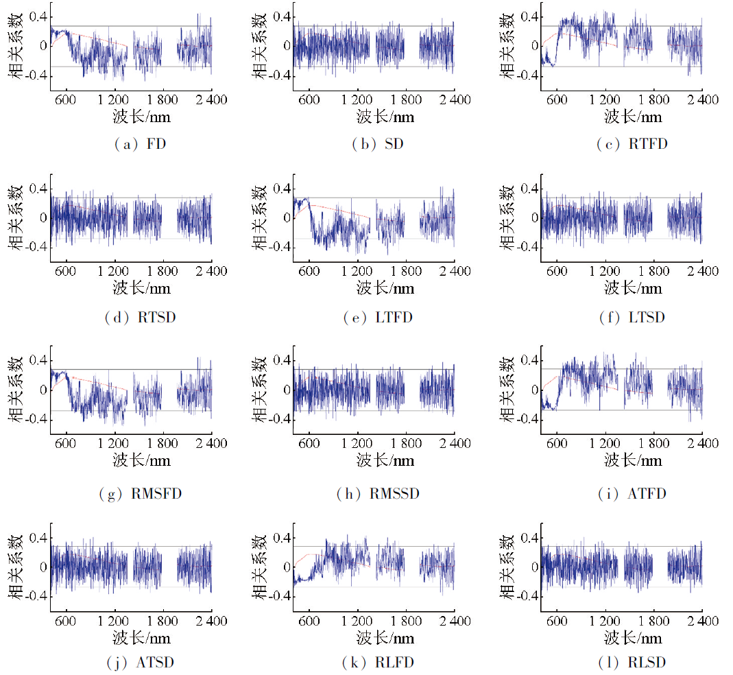
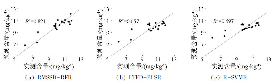
Abstract Arsenic (As) is a metalloid element with high carcinogenicity, rendering it particularly important to detect As content in soils in a swift and accurate manner. The study focused on the topsoil in Urumqi City, where 84 soil samples were collected and tested for their As content and original spectral reflectance. This study examined the relationships of As content in the soils with the spectral reflectance under the original spectra and 12 spectral transformations using the Pearson correlation analysis, followed by screening characteristic bands. Hyperspectral models for the inversion of As content in soils were developed using partial least squares regression (PLSR), random forest regression (RFR), and support vector machine regression (SVMR). Finally, the prediction performance of the hyperspectral models was elevated based on the coefficients of determination (R2), root-mean-square errors (RMSEs), and mean absolute errors (MAEs). The results indicated that applying differential transformations to the original spectral data can effectively enhance the spectral features and improve the correlation between spectral reflectance and As content in soils. The prediction performance of the hyperspectral models decreased in the order of RFR, SVMR, and PLSR. The RFR model based on root-mean-square second order differentiation (RMSSD-RFR) exhibited the best fitting effects and the highest prediction stability, with R2 of 0.821, a RMSE of 0.143 mg/kg, and a MAE of 0.523 mg/kg. This study provides a scientific basis for developing hyperspectral models for the inversion of As content in soils in an oasis city.
|
| Keywords
urban soil
As
hyperspectral inversion
spectral transformation
inversion model
|
|
|
|
Issue Date: 17 February 2025
|
|
|
| [1] |
郭学飞, 曹颖, 焦润成, 等. 基于高光谱的北京铁矿区土壤重金属镍元素含量反演研究[J]. 土壤通报, 2021, 52(4):960-967.
|
| [1] |
Guo X F, Cao Y, Jiao R C, et al. An inversion of soil nickel contents with hyperspectral in iron mine area of Beijing[J]. Chinese Journal of Soil Science, 2021, 52(4):960-967.
|
| [2] |
温其谦, 阎秀兰, 申俊峰, 等. 半壁山金矿矿业活动区砷赋存的矿物特征及其对农田土壤砷累积的影响[J]. 环境科学, 2019, 40(11):5090-5097.
|
| [2] |
Wen Q Q, Yan X L, Shen J F, et al. Mineral characteristics of arsenic in the active area of the Banbishan gold mine and its effect on arsenic accumulation in farmland soil[J]. Environmental Science, 2019, 40(11):5090-5097.
|
| [3] |
邵金秋, 温其谦, 阎秀兰, 等. 天然含铁矿物对砷的吸附效果及机制[J]. 环境科学, 2019, 40(9):4072-4080.
|
| [3] |
Shao J Q, Wen Q Q, Yan X L, et al. Adsorption and mechanism of arsenic by natural iron-containing minerals[J]. Environmental Science, 2019, 40(9):4072-4080.
|
| [4] |
贺军亮, 张淑媛, 查勇, 等. 高光谱遥感反演土壤重金属含量研究进展[J]. 遥感技术与应用, 2015, 30(3):407-412.
doi: 10.11873/j.issn.1004\|0323.2015.3.0407
|
| [4] |
He J L, Zhang S Y, Zha Y, et al. Review of retrieving soil heavy metal content by hyperspectral remote sensing[J]. Remote Sensing Technology and Application, 2015, 30(3):407-412.
|
| [5] |
Tan K, Wang H M, Chen L H, et al. Estimation of the spatial distribution of heavy metal in agricultural soils using airborne hyperspectral imaging and random forest[J]. Journal of Hazardous Materials, 2020,382:120987.
|
| [6] |
晏红波, 韦晚秋, 卢献健, 等. 基于高光谱特征的土壤含水量遥感反演方法综述[J]. 自然资源遥感, 2022, 34(2):1-9.doi:10.6046/zrzyyg.2021126.
|
| [6] |
Yan H B, Wei W Q, Lu X J, et al. A review of remote sensing inversion methods for estimating soil water content based on hyperspectral characteristics[J]. Remote Sensing for Natural Resources, 2022, 34(2):1-9.doi:10.6046/zrzyyg.2021126.
|
| [7] |
Sawut R, Kasim N, Abliz A, et al. Possibility of optimized indices for the assessment of heavy metal contents in soil around an open pit coal mine area[J]. International Journal of Applied Earth Observation and Geoinformation, 2018,73:14-25.
|
| [8] |
王嘉芃, 徐建国, 沈家晓, 等. 德兴铜矿矿山重金属污染修复效果高光谱遥感评价[J]. 自然资源遥感, 2023, 35(3):284-291.doi:10.6046/zrzyyg.2022196.
|
| [8] |
Wang J P, Xu J G, Shen J X, et al. Evaluating the remediation effect of heavy metal pollution in the Dexing copper mine based on hyperspectral remote sensing[J]. Remote Sensing for Natural Resources, 2023, 35(3):284-291.doi:10.6046/zrzyyg.2022196.
|
| [9] |
杨君怡, 钱乐祥, 郑艳伟, 等. 基于高光谱的土壤砷和铜元素含量估算[J]. 科技通报, 2018, 34(11):112-119,124.
|
| [9] |
Yang J Y, Qian L X, Zheng Y W, et al. Estimation of the content of arsenic and copper in soil based on hyperspectral data[J]. Bulletin of Science and Technology, 2018, 34(11):112-119,124.
|
| [10] |
郑光辉, 周生路, 吴绍华. 土壤砷含量高光谱估算模型研究[J]. 光谱学与光谱分析, 2011, 31(1):173-176.
|
| [10] |
Zheng G H, Zhou S L, Wu S H. Prediction of As in soil with reflectance spectroscopy[J]. Spectroscopy and Spectral Analysis, 2011, 31(1):173-176.
|
| [11] |
李志远, 邓帆, 贺军亮, 等. 土壤重金属砷的高光谱估算模型[J]. 光谱学与光谱分析, 2021, 41(9):2872-2878.
|
| [11] |
Li Z Y, Deng F, He J L, et al. Hyperspectral estimation model of heavy metal arsenic in soil[J]. Spectroscopy and Spectral Analysis, 2021, 41(9):2872-2878.
|
| [12] |
王泽强, 张冬有, 徐夕博, 等. 基于遥感时-空-谱特征及随机森林模型的土壤重金属空间分布预测[J]. 环境科学, 2024, 45(3):1713-1723.
|
| [12] |
Wang Z Q, Zhang D Y, Xu X B, et al. Distribution prediction of soil heavy metals based on remote sensing temporal-spatial-spectral features and random forest model[J]. Environmental Science, 2024, 45(3):1713-1723.
|
| [13] |
史广, 刘庚, 赵龙, 等. 基于多源环境数据和随机森林模型的农田土壤砷空间分布模拟[J]. 环境科学学报, 2020, 40(8):2993-3000.
|
| [13] |
Shi G, Liu G, Zhao L, et al. Prediction of arsenic for farmland soil based on multi source environmental data and random forest model[J]. Acta Scientiae Circumstantiae, 2020, 40(8):2993-3000.
|
| [14] |
袁自然, 魏立飞, 张杨熙, 等. 优化CARS结合PSO-SVM算法农田土壤重金属砷含量高光谱反演分析[J]. 光谱学与光谱分析, 2020, 40(2):567-573.
|
| [14] |
Yuan Z R, Wei L F, Zhang Y X, et al. Hyperspectral inversion and analysis of heavy metal arsenic content in farmland soil based on optimizing CARS combined with PSO-SVM algorithm[J]. Spectroscopy and Spectral Analysis, 2020, 40(2):567-573.
|
| [15] |
易兴松, 兰安军, 文锡梅, 等. 基于ASD和GaiaSky-mini的农田土壤重金属污染监测[J]. 生态学杂志, 2018, 37(6):1781-1788.
|
| [15] |
Yi X S, Lan A J, Wen X M, et al. Monitoring of heavy metals in farmland soils based on ASD and GaiaSky-mini[J]. Chinese Journal of Ecology, 2018, 37(6):1781-1788.
|
| [16] |
麦麦提吐尔逊·艾则孜, 阿吉古丽·马木提, 艾尼瓦尔·买买提. 新疆焉耆盆地辣椒地土壤重金属污染及生态风险预警[J]. 生态学报, 2018, 38(3):1075-1086.
|
| [16] |
Mamattursun E, Ajigul M, Anwar M. Soil heavy metal pollution and ecological risk warning assessment of pepper field in Yanqi Basin,Xinjiang[J]. Acta Ecologica Sinica, 2018, 38(3):1075-1086.
|
| [17] |
安柏耸, 王雪梅, 黄晓宇, 等. 基于连续小波变换的土壤重金属镉含量的高光谱估测[J]. 地球与环境, 2023, 51(2):246-253.
|
| [17] |
An B S, Wang X M, Huang X Y, et al. Hyperspectral estimation of heavy metal cadmium content in soil based on continuous wavelet transform[J]. Earth and Environment, 2023, 51(2):246-253.
|
| [18] |
Liu W W, Li M J, Zhang M Y, et al. Hyperspectral inversion of mercury in reed leaves under different levels of soil mercury contamination[J]. Environmental Science and Pollution Research International, 2020, 27(18):22935-22945.
doi: 10.1007/s11356-020-08807-z
pmid: 32329007
|
| [19] |
Leone A P, Viscarra-Rossel R A, Amenta P, et al. Prediction of soil properties with PLSR and vis-NIR spectroscopy:Application to Mediterranean soils from southern Italy[J]. Current Analytical Chemistry, 2012, 8(2):283-299.
|
| [20] |
Wei L F, Pu H C, Wang Z X, et al. Estimation of soil arsenic content with hyperspectral remote sensing[J]. Sensors, 2020, 20(14):4056.
|
| [21] |
阿地拉·艾来提, 麦麦提吐尔逊·艾则孜, 靳万贵, 等. 新疆库尔勒市道路积尘重金属污染及健康风险评价[J]. 中国地质, 2020, 47(6):1915-1925.
|
| [21] |
Adila H, Mamattursun E, Jin W G, et al. Pollution and health risks assessment of heavy metals of road dust in Korla City,Xinjiang[J]. Geology in China, 2020, 47(6):1915-1925.
|
| [22] |
李全坤, 赵万伏, 文宇博, 等. 基于可见—近红外反射光谱的典型农田重金属污染风险分类研究[J]. 高校地质学报, 2022, 28(6):799-813.
|
| [22] |
Li Q K, Zhao W F, Wen Y B, et al. Classification of heavy metal contamination risk in typical agricultural soils by visible and near infrared reflectance spectroscopy[J]. Geological Journal of China Universities, 2022, 28(6):799-813.
|
| [23] |
郭云开, 张思爱, 谢晓峰, 等. 基于 GA-SVM 的耕地土壤重金属含量高光谱反演方法的研究[J]. 土壤通报, 2021, 52(4):968-974.
|
| [23] |
Guo Y K, Zhang S A, Xie X F, et al. The hyperspectral inversion method of heavy metal contents in cultivated soils based on GA-SVM[J]. Chinese Journal of Soil Science, 2021, 52(4):968-974.
|
| [24] |
阿依努尔·麦提努日, 麦麦提吐尔逊·艾则孜, 李新国. 基于地理加权回归模型的葡萄园土壤砷含量高光谱反演[J]. 环境监测管理与技术, 2021, 33(4):45-48.
|
| [24] |
Aynur M, Mamattursun E, Li X G. Hyperspectral inversion of arsenic content in vineyard soil based on geographically weighted regression model[J]. The Administration and Technique of Environmental Monitoring, 2021, 33(4):45-48.
|
|
Viewed |
|
|
|
Full text
|
|
|
|
|
Abstract
|
|
|
|
|
Cited |
|
|
|
|
| |
Shared |
|
|
|
|
| |
Discussed |
|
|
|
|
 2025,
Vol. 37
2025,
Vol. 37