|
|
 |
|

|
|
|
Time series surface deformation of the upper reaches of Huangdeng hydropower station in Lanping County based on ascending and descending SAR data |
YU Wenxuan1( ), LI Yimin2(), JI Peikun2, FENG Xianjie1, XIANG Qianying1 ), LI Yimin2(), JI Peikun2, FENG Xianjie1, XIANG Qianying1 |
1. Institute of International Rivers and Eco-security, Yunnan University,Kunming 650500, China
2. College of Earth Science, Yunnan University, Kunming 650500, China |
|
|
|
|
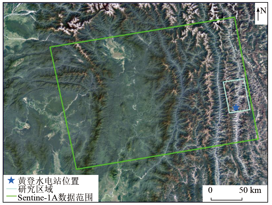
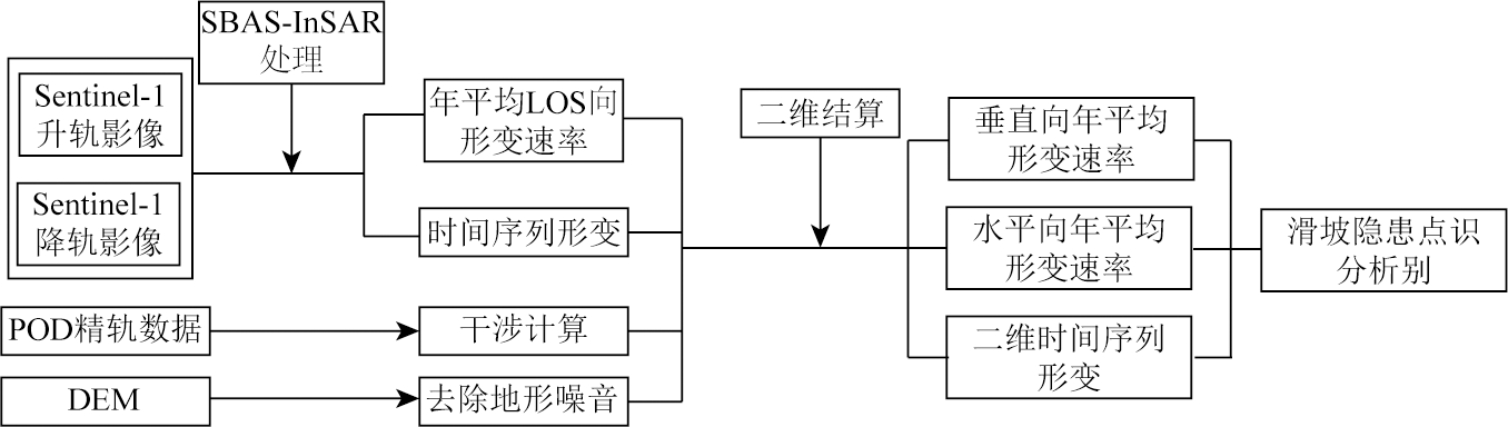
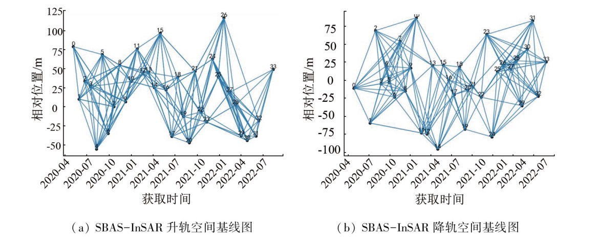
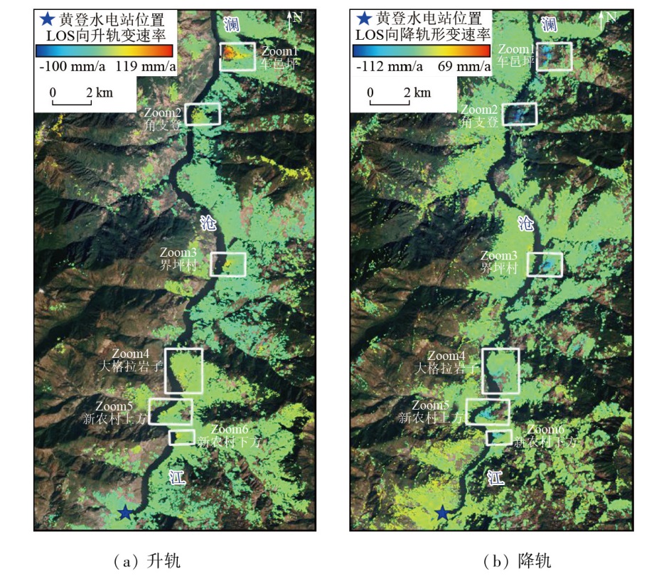
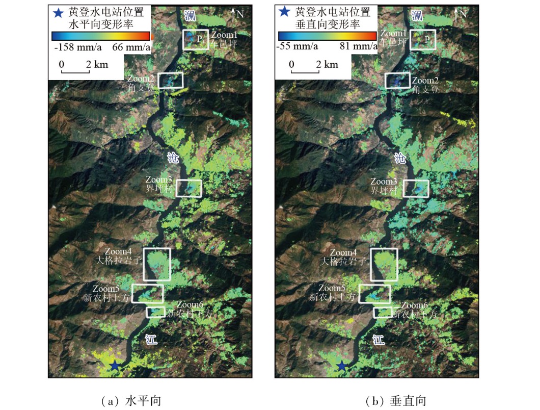
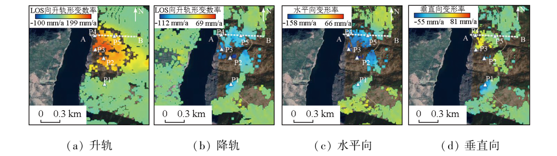
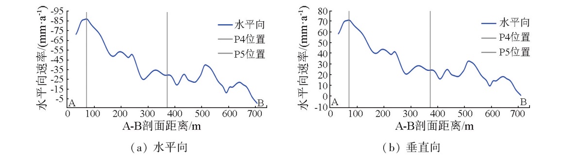
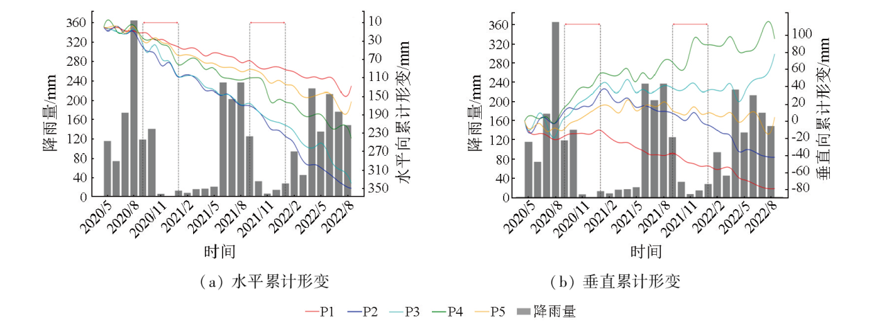
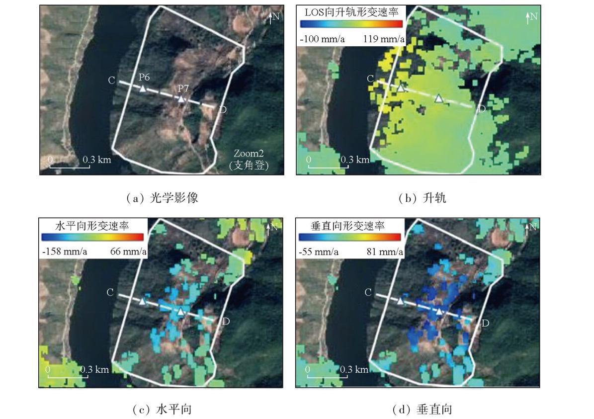
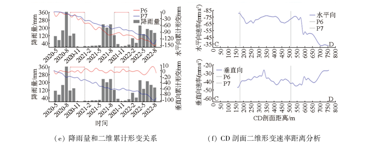
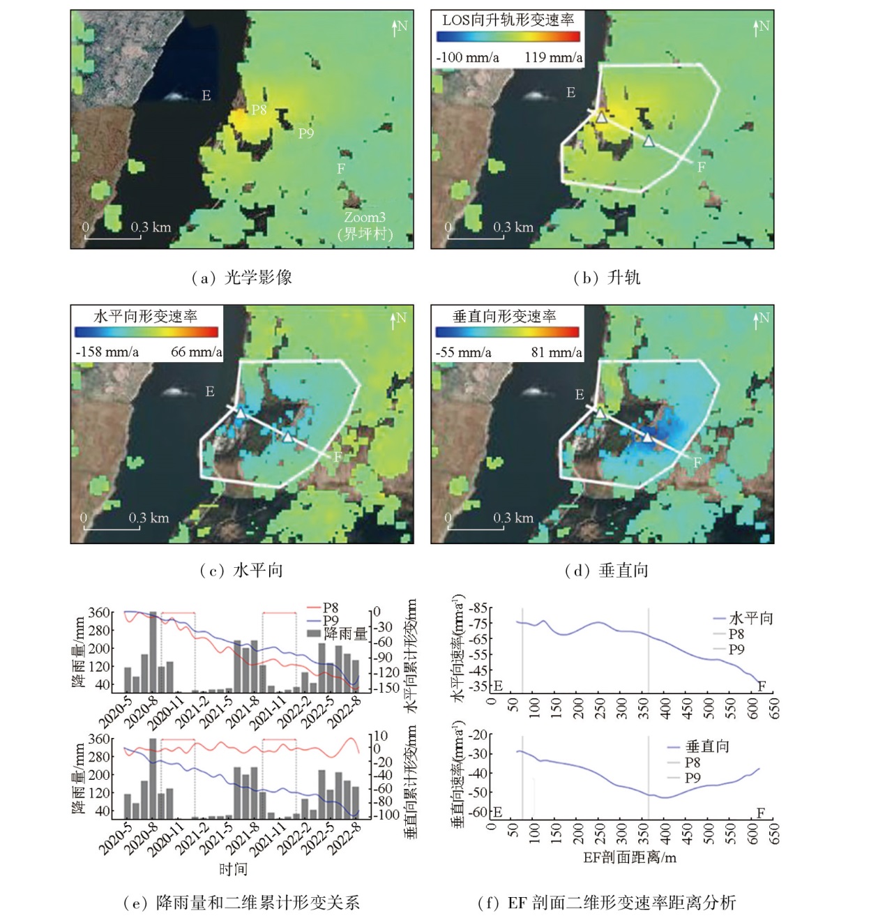
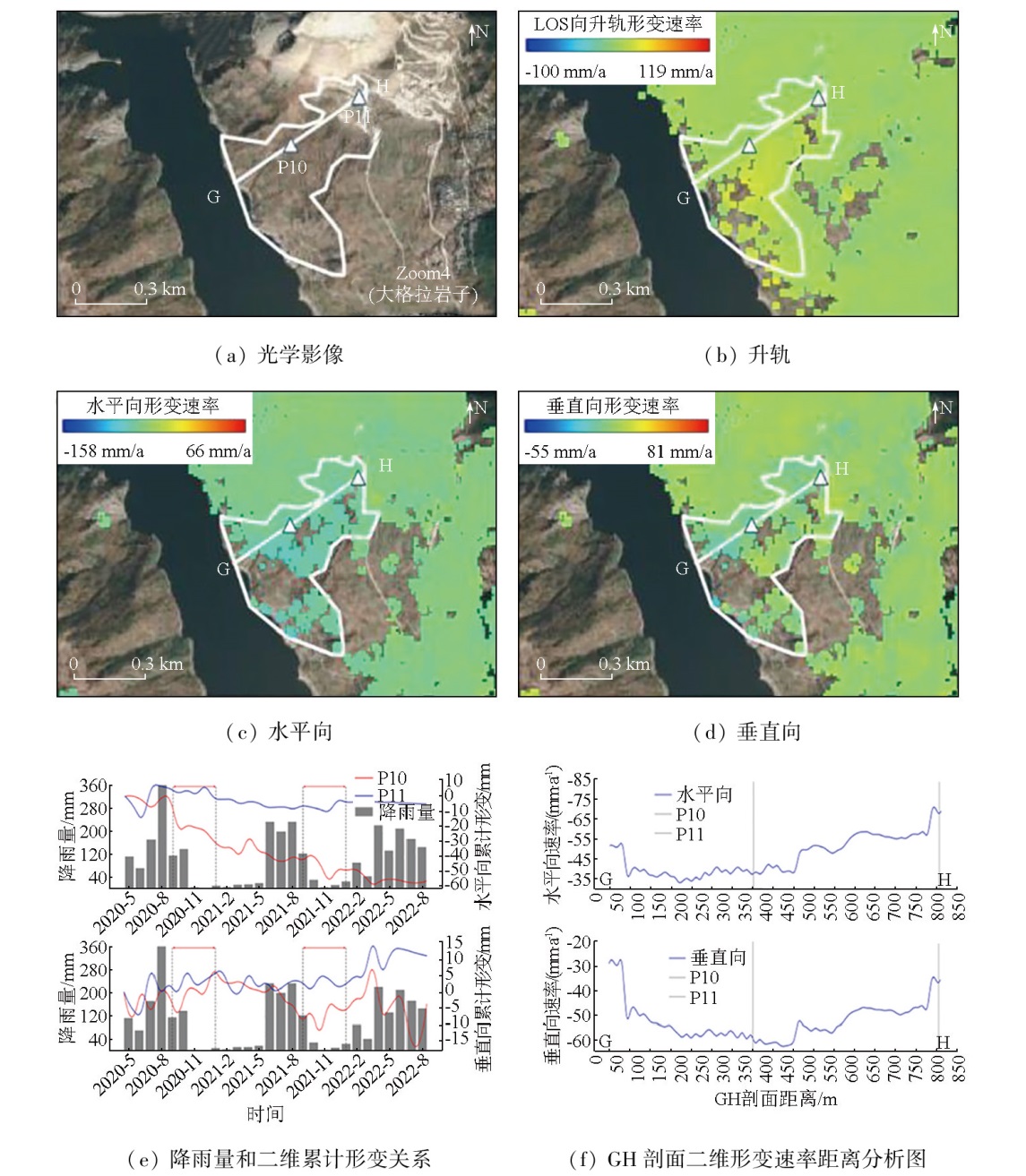
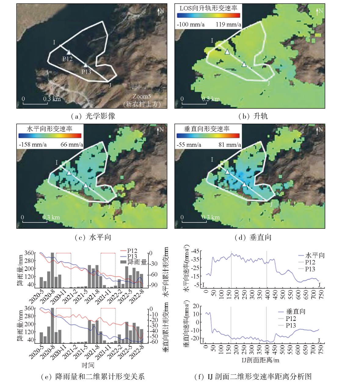
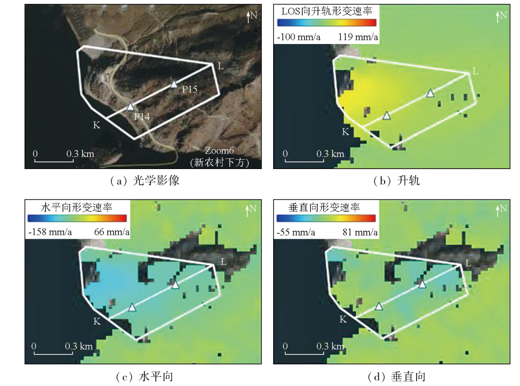
Abstract The interferometric synthetic aperture radar (InSAR) technique is widely applied to surface deformation monitoring, providing all-weather, all-time, and high-precision measurements over large areas. However, due to the limitations of the single deformation observation method, significant uncertainties inevitably arise during the monitoring process, leading to potential misinterpretations. Using the SBAS-InSAR (small baseline subset) two-dimensional solution technique based on ascending and descending SAR data, this study analyzed the surface deformations of the upper reaches of the Huangdeng Hydropower Station from April 2020 to August 2022. A total of 34 scenes of ascending and descending data from the Sentinel-1 satellite were used to derive the two-dimensional deformations of the upper reaches, with six potential landslide hazard sites there being identified. The results indicate that the study area displayed a predominance of horizontal surface deformations, with the highest two-dimensional deformation rates of up to 158 mm/a horizontally and 81 mm/a vertically observed in the Cheyiping area. Additionally, by correlation analysis between the distance from the Lancang River bank, rainfall, and the time-series deformations, this study identified the distribution of two-dimensional deformations in the upper reaches and its seasonal variations.
|
| Keywords
SBAS
time series InSAR
two-dimensional analysis
deformation monitoring
|
|
|
|
Issue Date: 23 December 2024
|
|
|
| [1] |
Bartle A. Hydropower potential and development activities[J]. Energy Policy, 2002, 30(14):1231-1239.
|
| [2] |
Hennig T, Wang W, Feng Y, et al. Review of Yunnan’s hydropower development.Comparing small and large hydropower projects regarding their environmental implications and socio-economic consequences[J]. Renewable and Sustainable Energy Reviews, 2013, 27:585-595.
|
| [3] |
Wang L, Chen C, Zou R, et al. Surface gravity and deformation effects of water storage changes in China’s Three Gorges Reservoir constrained by modeled results and in situ measurements[J]. Journal of Applied Geophysics, 2014, 108:25-34.
|
| [4] |
Bosa S, Petti M. Shallow water numerical model of the wave generated by the Vajont landslide[J]. Environmental Modelling and Software, 2011, 26(4):406-418.
|
| [5] |
Zhang L, Liao M, Balz T, et al. Monitoring landslide activities in the three gorges area with multi-frequency satellite SAR data sets[M]//Modern Technologies for Landslide Monitoring and Prediction. Berlin,Heidelberg: Springer Berlin Heidelberg, 2015:181-208.
|
| [6] |
Froude M J, Petley D N. Global fatal landslide occurrence from 2004 to 2016[J]. Natural Hazards and Earth System Sciences, 2018, 18(8):2161-2181.
|
| [7] |
云烨, 吕孝雷, 付希凯, 等. 星载InSAR技术在地质灾害监测领域的应用[J]. 雷达学报, 2020, 9(1):73-85.
|
| [7] |
Yun Y, Lyu X L, Fu X K, et al. Application of spaceborne interferometric synthetic aperture radar to geohazard monitoring[J]. Journal of Radars, 2020, 9(1):73-85.
|
| [8] |
Sandwell D T, Price E J. Phase gradient approach to stacking interferograms[J]. Journal of Geophysical Research:Solid Earth, 1998, 103(B12):30183-30204.
|
| [9] |
Ferretti A, Prati C, Rocca F. Analysis of permanent scatterers in SAR interferometry[C]// IGARSS 2000.IEEE 2000 International Geoscience and Remote Sensing Symposium.Taking the Pulse of the Planet:The Role of Remote Sensing in Managing the Environment.Proceedings (Cat.No.00CH37120).Honolulu,HI,USA.IEEE, 2002:761-763.
|
| [10] |
Berardino P, Fornaro G, Lanari R, et al. A new algorithm for surface deformation monitoring based on small baseline differential SAR interferograms[J]. IEEE Transactions on Geoscience and Remote Sensing, 2002, 40(11):2375-2383.
|
| [11] |
杨帆, 巩世彬, 陈梓萌. 时序InSAR 技术对大连主城区沉降分析[J]. 测绘工程, 2022, 31(3):61-67.
|
| [11] |
Yang F, Gong S B, Chen Z M. Time series InSAR technology for settlement analysis of Dalian main urban area[J]. Engineering of Surveying and Mapping, 2022, 31(3):61-67.
|
| [12] |
虎小强, 杨树文, 闫恒, 等. 基于时序InSAR的新疆阿希矿区地表形变监测与分析[J]. 自然资源遥感, 2023, 35(1):171-179.doi:10.6046/zrzyyg.2021415.
|
| [12] |
Hu X Q, Yang S W, Yan H, et al. Time-series InSAR-based monitoring and analysis of surface deformation in the Axi mining area,Xinjiang[J]. Remote Sensing for Natural Resources, 2023, 35(1):171-179.doi:10.6046/zrzyyg.2021415.
|
| [13] |
向淇文, 郭金城, 汪娟, 等. 时序InSAR在贵州区域地质灾害隐患识别的应用[J]. 测绘科学, 2022, 47(9):112-119.
|
| [13] |
Xiang Q W, Guo J C, Wang J, et al. Application of time series InSAR in recognition of hidden dangers of geological hazards in Guizhou area[J]. Science of Surveying and Mapping, 2022, 47(9):112-119.
|
| [14] |
张亚迪, 李煜东, 董杰, 等. 时序InSAR技术探测芒康地区滑坡灾害隐患[J]. 遥感学报, 2019, 23(5):987-996.
|
| [14] |
Zhang Y D, Li Y D, Dong J, et al. Landslide hazard detection in Markam with time-series InSAR analyses[J]. Journal of Remote Sensing, 2019, 23(5):987-996.
|
| [15] |
Liu P, Li Z, Hoey T, et al. Using advanced InSAR time series techniques to monitor landslide movements in Badong of the Three Gorges region,China[J]. International Journal of Applied Earth Observation and Geoinformation, 2013, 21:253-264.
|
| [16] |
Zhao C Y, Kang Y, Zhang Q, et al. Landslide detection and monitoring with insar technique over upper reaches of Jinsha River,China[C]// 2016 IEEE International Geoscience and Remote Sensing Symposium (IGARSS).Beijing,China.IEEE, 2016:2881-2884.
|
| [17] |
Samsonov S, Dille A, Dewitte O, et al. Satellite interferometry for mapping surface deformation time series in one,two and three dimensions:A new method illustrated on a slow-moving landslide[J]. Engineering Geology, 2020, 266:105471.
|
| [18] |
Maghsoudi Y, van der Meer F, Hecker C, et al. Using PS-InSAR to detect surface deformation in geothermal areas of West Java in Indonesia[J]. International Journal of Applied Earth Observation and Geoinformation, 2018, 64:386-396.
|
| [19] |
Chen Y, Yu S, Tao Q, et al. Accuracy verification and correction of D-InSAR and SBAS-InSAR in monitoring mining surface subsidence[J]. Remote Sensing, 2021, 13(21):4365.
|
| [20] |
Umarhadi D A, Avtar R, Widyatmanti W, et al. Use of multifrequency (C-band and L-band) SAR data to monitor peat subsidence based on time-series SBAS InSAR technique[J]. Land Degradation and Development, 2021, 32(16):4779-4794.
|
| [21] |
Tao Q, Wang F, Guo Z, et al. Accuracy verification and evaluation of small baseline subset (SBAS) interferometric synthetic aperture radar (InSAR) for monitoring mining subsidence[J]. European Journal of Remote Sensing, 2021, 54(1):642-663.
|
| [22] |
Zhang P, Guo Z, Guo S, et al. Land subsidence monitoring method in regions of variable radar reflection characteristics by integrating PS-InSAR and SBAS-InSAR techniques[J]. Remote Sensing, 2022, 14(14):3265.
|
| [23] |
Shanker P, Casu F, Zebker H A, et al. Comparison of persistent scatterers and small baseline time-series InSAR results:A case study of the San francisco bay area[J]. IEEE Geoscience and Remote Sensing Letters, 2011, 8(4):592-596.
|
| [24] |
Crosetto M, Monserrat O, Cuevas-González M, et al. Persistent scatterer interferometry:A review[J]. ISPRS Journal of Photogrammetry and Remote Sensing, 2016, 115:78-89.
|
| [25] |
Hu J, Li Z W, Ding X L, et al. Resolving three-dimensional surface displacements from InSAR measurements:A review[J]. Earth-Science Reviews, 2014, 133:1-17.
|
| [26] |
Zhu Y F, Yao X, Yao C, et al. Integration of vertical and horizontal deformation derived by SAR observation for identifying landslide motion patterns in a basaltic weathered crust region of Guizhou,China[J]. Remote Sensing, 2022, 14(16):4014.
|
| [27] |
Meng Q, Confuorto P, Peng Y, et al. Regional recognition and classification of active loess landslides using two-dimensional deformation derived from sentinel-1 interferometric radar data[J]. Remote Sensing, 2020, 12(10):1541.
|
| [28] |
Chen Q, Zhang H, Xu B, et al. Accessing the time-series two-dimensional displacements around a reservoir using multi-orbit SAR datasets:A case study of xiluodu hydropower station[J]. Remote Sensing, 2022, 15(1):168.
|
| [29] |
Ning Y, Tang H, Zhang G, et al. A complex rockslide developed from a deep-seated toppling failure in the upper Lancang River,Southwest China[J]. Engineering Geology, 2021, 293:106329.
|
| [30] |
Zhong R, Zhao T, He Y, et al. Hydropower change of the water tower of Asia in 21st century:A case of the Lancang River hydropower base,upper Mekong[J]. Energy, 2019, 179:685-696.
|
| [31] |
Wang H L, Zhao X F, Chen H J, et al. Evaluation of toppling rock slopes using a composite cloud model with DEMATEL-CRITIC method[J]. Water Science and Engineering, 2023, 16(3):280-288.
|
| [32] |
Lanari R, Mora O, Manunta M, et al. A small-baseline approach for investigating deformations on full-resolution differential SAR interferograms[J]. IEEE Transactions on Geoscience and Remote Sensing, 2004, 42(7):1377-1386.
|
| [33] |
Fobert M A, Singhroy V, Spray J G. InSAR monitoring of landslide activity in Dominica[J]. Remote Sensing, 2021, 13(4):815.
|
| [34] |
Fuhrmann T, Garthwaite M C. Resolving three-dimensional surface motion with InSAR:Constraints from multi-geometry data fusion[J]. Remote Sensing, 2019, 11(3):241.
|
| [35] |
Wang H, Sun P, Zhang S, et al. Rainfall-induced landslide in loess area,Northwest China:A case study of the Changhe landslide on September 14,2019,in Gansu Province[J]. Landslides, 2020, 17(9):2145-2160.
|
| [36] |
Guo C, Ma G, Xiao H, et al. Displacement back analysis of reservoir landslide based on multi-source monitoring data:A case study of the cheyiping landslide in the Lancang River Basin,China[J]. Remote Sensing, 2022, 14(11):2683.
|
| [37] |
Xia M, Ren G M, Ma X L. Deformation and mechanism of landslide influenced by the effects of reservoir water and rainfall,Three Gorges,China[J]. Natural Hazards, 2013, 68(2):467-482.
|
| [38] |
Li D, Yin K, Leo C. Analysis of Baishuihe landslide influenced by the effects of reservoir water and rainfall[J]. Environmental Earth Sciences, 2010, 60(4):677-687.
|
| [39] |
Ma S, Qiu H, Hu S, et al. Characteristics and geomorphology change detection analysis of the Jiangdingya landslide on July 12,2018,China[J]. Landslides, 2021, 18(1):383-396.
|
| [40] |
Cohen-Waeber J, Bürgmann R, Chaussard E, et al. Spatiotemporal patterns of precipitation-modulated landslide deformation from independent component analysis of InSAR time series[J]. Geophysical Research Letters, 2018, 45(4):1878-1887.
|
|
Viewed |
|
|
|
Full text
|
|
|
|
|
Abstract
|
|
|
|
|
Cited |
|
|
|
|
| |
Shared |
|
|
|
|
| |
Discussed |
|
|
|
|
 2024,
Vol. 36
2024,
Vol. 36