|
|
 |
|

|
|
|
BDANet-based assessment of building damage from earthquake disasters |
ZHAO Jinling1( ), HUANG Jian1, LIANG Zijun1, ZHAO Xuedan1, JIN Tao1, GE Hanghang1, WEI Xiaoyan3, SHAO Yuanzheng2 ), HUANG Jian1, LIANG Zijun1, ZHAO Xuedan1, JIN Tao1, GE Hanghang1, WEI Xiaoyan3, SHAO Yuanzheng2 |
1. Data Company of Xinjiang Oilfield Company, Karamay 834000, China
2. Collaborative Innovation Center of Geospatial Technology, Wuhan University, Wuhan 430079, China
3. Yunnan Provincial Archives of Surveying and Mapping (Yunnan Provincial Geomatics Centre), Kunming 650034, China |
|
|
|
|
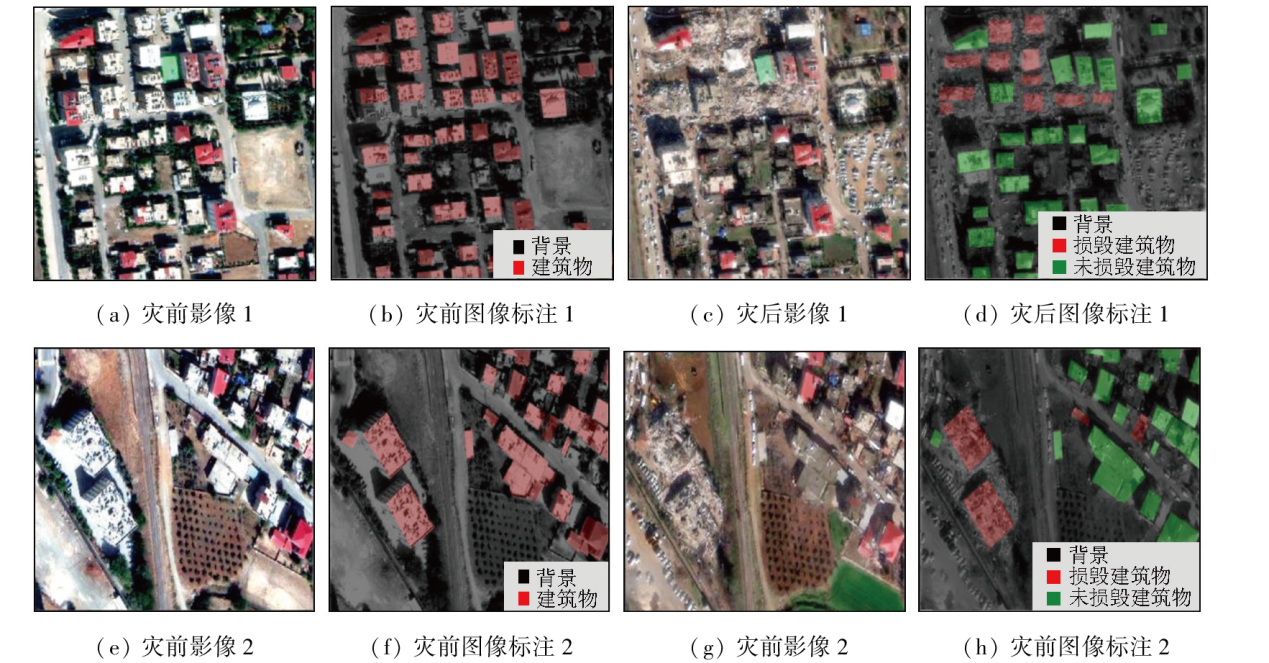
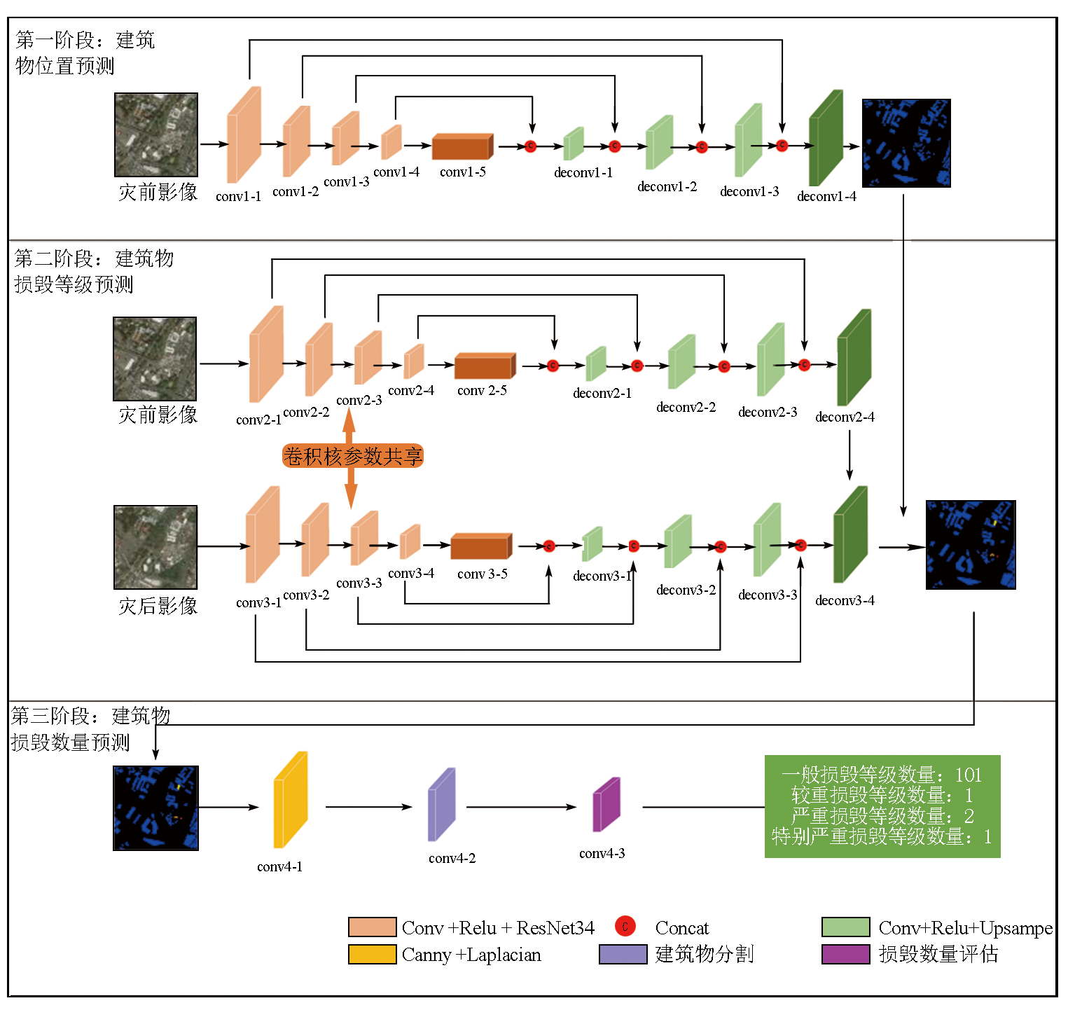
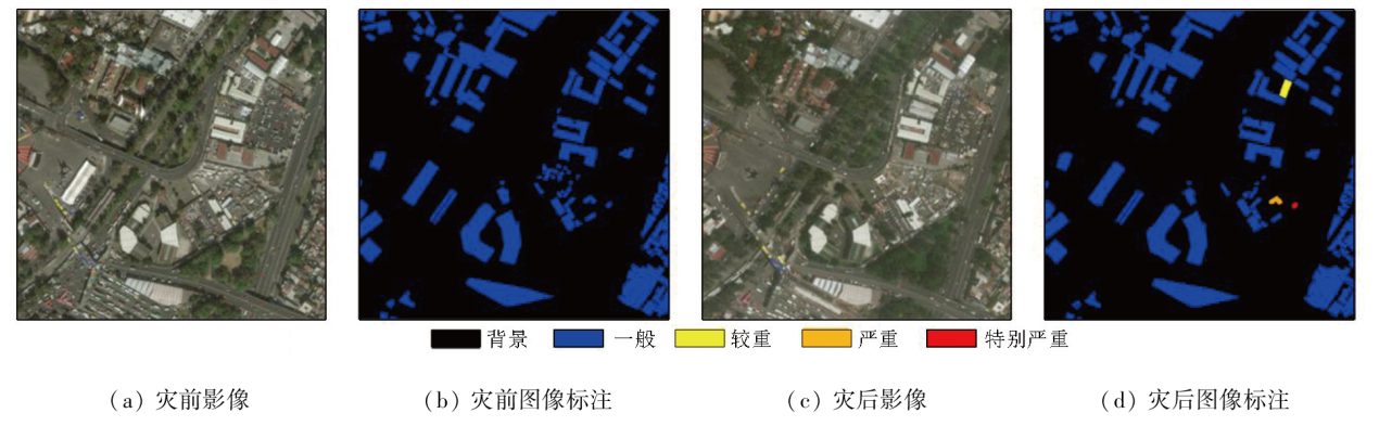
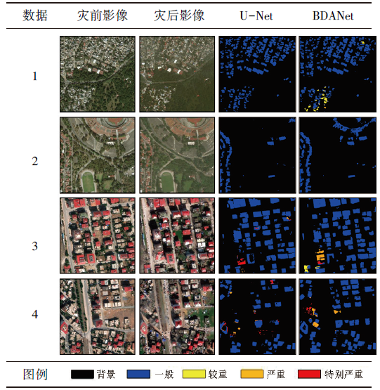
Abstract The rapid assessment of building damage following destructive earthquakes serves as a critical foundation for decision-making and technical guarantee in post-earthquake scientific evaluations, holding great significance in humanitarian aid and emergency response. This study aims to overcome the challenge in rapidly quantifying the number of buildings affected. Considering that most existing post-earthquake building damage assessments based on remote sensing images rely on pre- and post-disaster image segmentation, this study, by using the U-Net deep convolutional neural network as the main model, introduced a three-stage convolutional neural network for building damage assessment (BDANet) framework that integrates assessment and prediction for post-earthquake building damage information. First, the encoder-decoder network structure of U-Net was used to extract building location information. Second, building damage was assessed using pre- and post-disaster images to localize and grade damage in the image segmentation results. Finally, the number of buildings damaged at various levels was predicted to support post-disaster rescue and reconstruction efforts. The study evaluated and quantified the levels of post-earthquake building damage in the M7.1 earthquake in Morelos State, central Mexico in 2017 and the M7.8 earthquake in Türkiye in 2023, confirming the accuracy and reliability of the proposed method. The experimental findings provide timely and precise data and technical support for post-disaster risk assessment.
|
| Keywords
remote sensing image
earthquake disaster
building damage
damage assessment
U-Net
|
|
|
|
Issue Date: 23 December 2024
|
|
|
| [1] |
He Y, Wang J, Liao C, et al. MS4D-net:Multitask-based semi-supervised semantic segmentation framework with perturbed dual mean teachers for building damage assessment from high-resolution remote sensing imagery[J]. Remote Sensing, 2023, 15(2):478.
|
| [2] |
Shen Y, Zhu S, Yang T, et al. BDANet:Multiscale convolutional neural network with cross-directional attention for building damage assessment from satellite images[J]. IEEE Transactions on Geoscience and Remote Sensing, 2021, 60:5402114.
|
| [3] |
眭海刚, 刘超贤, 黄立洪, 等. 遥感技术在震后建筑物损毁检测中的应用[J]. 武汉大学学报(信息科学版), 2019, 44(7):1008-1019.
|
| [3] |
Sui H G, Liu C X, Huang L H, et al. Application of remote sensing technology in earthquake-induced building damage detection[J]. Geomatics and Information Science of Wuhan University, 2019, 44(7):1008-1019.
|
| [4] |
Yang W, Zhang X, Luo P. Transferability of convolutional neural network models for identifying damaged buildings due to earthquake[J]. Remote Sensing, 2021, 13(3):504.
|
| [5] |
吴鹏天昊, 吴立新, 沈永林, 等. 基于高分影像纹理分维变化的灾害自动识别方法[J]. 地理与地理信息科学, 2012, 28(2):9-13.
|
| [5] |
Wu P T H, Wu L X, Shen Y L, et al. Disaster auto-recognition method based on HSR-image’s texture fractal monotonous change[J]. Geography and Geo-Information Science, 2012, 28(2):9-13.
|
| [6] |
Cheng Q, Tian Y, Lu X, et al. Near-real-time prompt assessment for regional earthquake-induced landslides using recorded ground motions[J]. Computers & Geosciences, 2021, 149:104709.
|
| [7] |
龚燃, 刘韬. 2018年国外对地观测卫星发展综述[J]. 国际太空, 2019(2):48-55.
|
| [7] |
Gong R, Liu T. Summary of the development of foreign earth observation satellites in 2018[J]. Space International, 2019(2):48-55.
|
| [8] |
Tang X, Gao X, Cao H, et al. The China ZY3-03 mission:Surveying and mapping technology for high-resolution remote sensing satellites[J]. IEEE Geoscience and Remote Sensing Magazine, 2020, 8(3):8-17.
|
| [9] |
宫鹏. 对遥感科学应用的一点看法[J]. 遥感学报, 2019, 23(4):567-569.
|
| [9] |
Gong P. Towards more extensive and deeper application of remote sensing[J]. National Remote Sensing Bulletin, 2019, 23(4):567-569.
|
| [10] |
Gupta R, Goodman B, Patel N, et al. Creating xBD:A dataset for assessing building damage from satellite imagery[C]// Proceedings of the IEEE Conference on Computer Vision and Pattern Re-cognition Workshops.IEEE, 2019:10-17.
|
| [11] |
Faisal A, Khan H. Application of GIS and remote sensing in disaster management:A critical review of flood management[C]// International Conference on Disaster Risk Mitigation. 2018.
|
| [12] |
Song D, Tan X, Wang B, et al. Integration of super-pixel segmentation and deep-learning methods for evaluating earthquake-da-maged buildings using single-phase remote sensing imagery[J]. International Journal of Remote Sensing, 2020, 41(3):1040-1066.
|
| [13] |
Chen C, Fu J, Gai Y, et al. Damaged bridges over water:Using high-spatial-resolution remote-sensing images for recognition,detection,and assessment[J]. IEEE Geoscience and Remote Sensing Magazine, 2018, 6(3):69-85.
|
| [14] |
Yeom J, Han Y, Chang A, et al. Hurricane building damage assessment using post-disaster UAV data[C]// IGARSS 2019-2019 IEEE International Geoscience and Remote Sensing Symposium.Yokohama,Japan.IEEE, 2019:9867-9870.
|
| [15] |
Tong X, Hong Z, Liu S, et al. Building-damage detection using pre- and post-seismic high-resolution satellite stereo imagery:A case study of the May 2008 Wenchuan earthquake[J]. ISPRS Journal of Photogrammetry and Remote Sensing, 2012, 68:13-27.
|
| [16] |
Dou M, Chen J, Chen D, et al. Modeling and simulation for natural disaster contingency planning driven by high-resolution remote sensing images[J]. Future Generation Computer Systems, 2014, 37:367-377.
|
| [17] |
Liu S, Marinelli D, Bruzzone L, et al. A review of change detection in multitemporal hyperspectral images:Current techniques,applications,and challenges[J]. IEEE Geoscience and Remote Sensing Magazine, 2019, 7(2):140-158.
|
| [18] |
Khan S H, He X, Porikli F, et al. Forest change detection in incomplete satellite images with deep neural networks[J]. IEEE Transactions on Geoscience and Remote Sensing, 2017, 55(9):5407-5423.
|
| [19] |
Wang Q, Yuan Z, Du Q, et al. GETNET:A general end-to-end 2-D CNN framework for hyperspectral image change detection[J]. IEEE Transactions on Geoscience and Remote Sensing, 2019, 57(1):3-13.
|
| [20] |
Zhan Y, Fu K, Yan M, et al. Change detection based on deep Siamese convolutional network for optical aerial images[J]. IEEE Geo-science and Remote Sensing Letters, 2017, 14(10):1845-1849.
|
| [21] |
Gao F, Dong J, Li B, et al. Automatic change detection in synthetic aperture radar images based on PCANet[J]. IEEE Geoscience and Remote Sensing Letters, 2016, 13(12):1792-1796.
|
| [22] |
Myint S W, Yuan M, Cerveny R S, et al. Categorizing natural disaster damage assessment using satellite-based geospatial techniques[J]. Natural Hazards and Earth System Sciences, 2008, 8(4):707-719.
|
| [23] |
Ma H, Liu Y, Ren Y, et al. Improved CNN classification method for groups of buildings damaged by earthquake,based on high resolution remote sensing images[J]. Remote Sensing, 2020, 12(2):260.
|
| [24] |
Nie Y, Zeng Q, Jiao J. Building damage assessment from post-event polsar image based on opce and template matching[C]// IGARSS 2019-2019 IEEE International Geoscience and Remote Sensing Symposium.Yokohama,Japan.IEEE, 2019:9402-9405.
|
| [25] |
Bialas J, Oommen T, Rebbapragada U, et al. Object-based classification of earthquake damage from high-resolution optical imagery using machine learning[J]. Journal of Applied Remote Sensing, 2016, 10(3):036025.
|
| [26] |
Cooner A J, Shao Y, Campbell J B. Detection of urban damage using remote sensing and machine learning algorithms:Revisiting the 2010 Haiti earthquake[J]. Remote Sensing, 2016, 8(10):868.
|
| [27] |
Liu P, Wei Y, Wang Q, et al. Research on post-earthquake landslide extraction algorithm based on improved U-Net model[J]. Remote Sensing, 2020, 12(5):894.
|
| [28] |
Xu J Z, Lu W, Li Z, et al. Building damage detection in satellite imagery using convolutional neural networks[J/OL]. arXiv, 2019(2019-10-14)[2023-09-28]. https://arxiv.org/abs/1910.06444.
url: https://arxiv.org/abs/1910.06444
|
| [29] |
Weber E, Kané H. Building disaster damage assessment in satellite imagery with multi-temporal fusion[J/OL]. arXiv, 2020 (2020-04-12)[2023-09-28]. https://arxiv.org/abs/2004.05525.
url: https://arxiv.org/abs/2004.05525
|
| [30] |
Hao H, Baireddy S, Bartusiak E R, et al. An attention-based system for damage assessment using satellite imagery[C]// IGARSS 2021 IEEE International Geoscience and Remote Sensing Symposium.Brussels,Belgium.IEEE, 2021:4396-4399.
|
| [31] |
Gupta R, Hosfelt R, Sajeev S, et al. xBD:A dataset for assessing building damage from satellite imagery[J/OL]. arXiv, 2019 (2019-10-14)[2023-09-28]. https://arxiv.org/abs/1911.09296.
url: https://arxiv.org/abs/1911.09296
|
| [32] |
Yun S, Han D, Chun S, et al. CutMix:Regularization strategy to train strong classifiers with localizable features[C]// 2019 IEEE/CVF International Conference on Computer Vision (ICCV).Seoul,Korea (South).IEEE, 2019:6022-6031.
|
| [33] |
Sepúlveda J, Velastın S A. F1 score assesment of Gaussian mixture background subtraction algorithms using the MuHAVi dataset[C]// 6th International Conference on Imaging for Crime Prevention and Detection (ICDP-15).London.London:IET, 2015:1-6.
|
| [34] |
Pereira R B, Plastino A, Zadrozny B, et al. Correlation analysis of performance measures for multi-label classification[J]. Information Processing & Management, 2018, 54(3):359-369.
|
|
Viewed |
|
|
|
Full text
|
|
|
|
|
Abstract
|
|
|
|
|
Cited |
|
|
|
|
| |
Shared |
|
|
|
|
| |
Discussed |
|
|
|
|
 2024,
Vol. 36
2024,
Vol. 36