|
|
 |
|

|
|
|
Remote sensing-based classification of crops on a farmland parcel scale and uncertainty analysis |
ZHANG Dongyun1( ), WU Tianjun2, LI Manjia1, GUO Yifei1, LUO Jiancheng1,3(), DONG Wen1 ), WU Tianjun2, LI Manjia1, GUO Yifei1, LUO Jiancheng1,3(), DONG Wen1 |
1. State Key Laboratory of Remote Sensing Science, Aerospace Information Research Institute, Chinese Academy of Sciences,Beijing 100101, China
2. School of Land Engineering, Chang’an University, Xi’an 710064, China
3. College of Resources and Environment, University of Chinese Academy of Sciences, Beijing 100049, China |
|
|
|
|
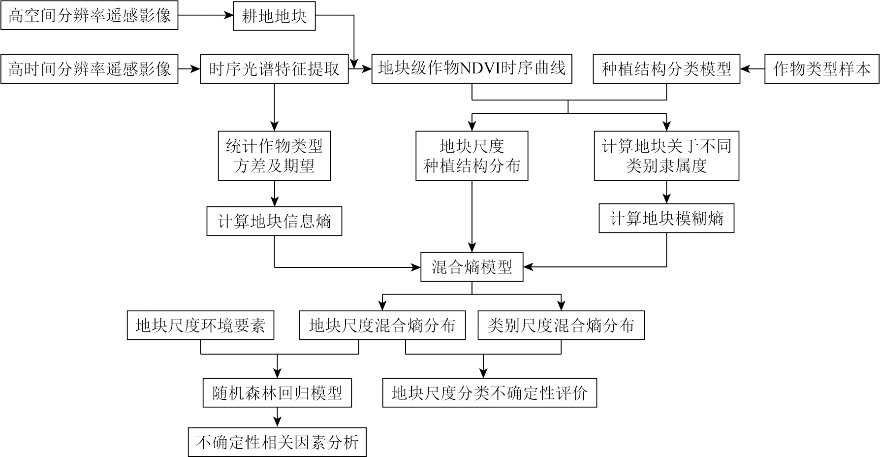
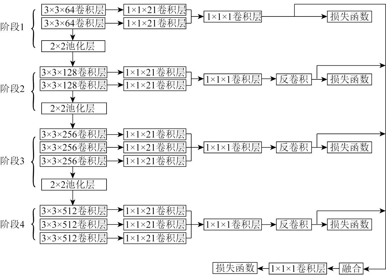
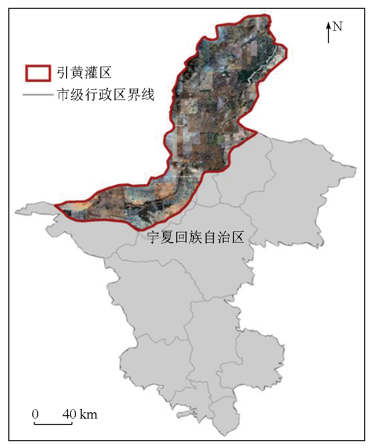
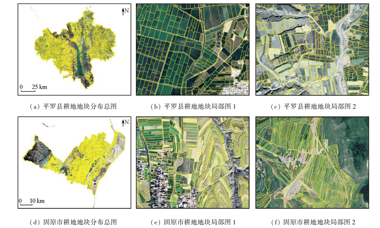
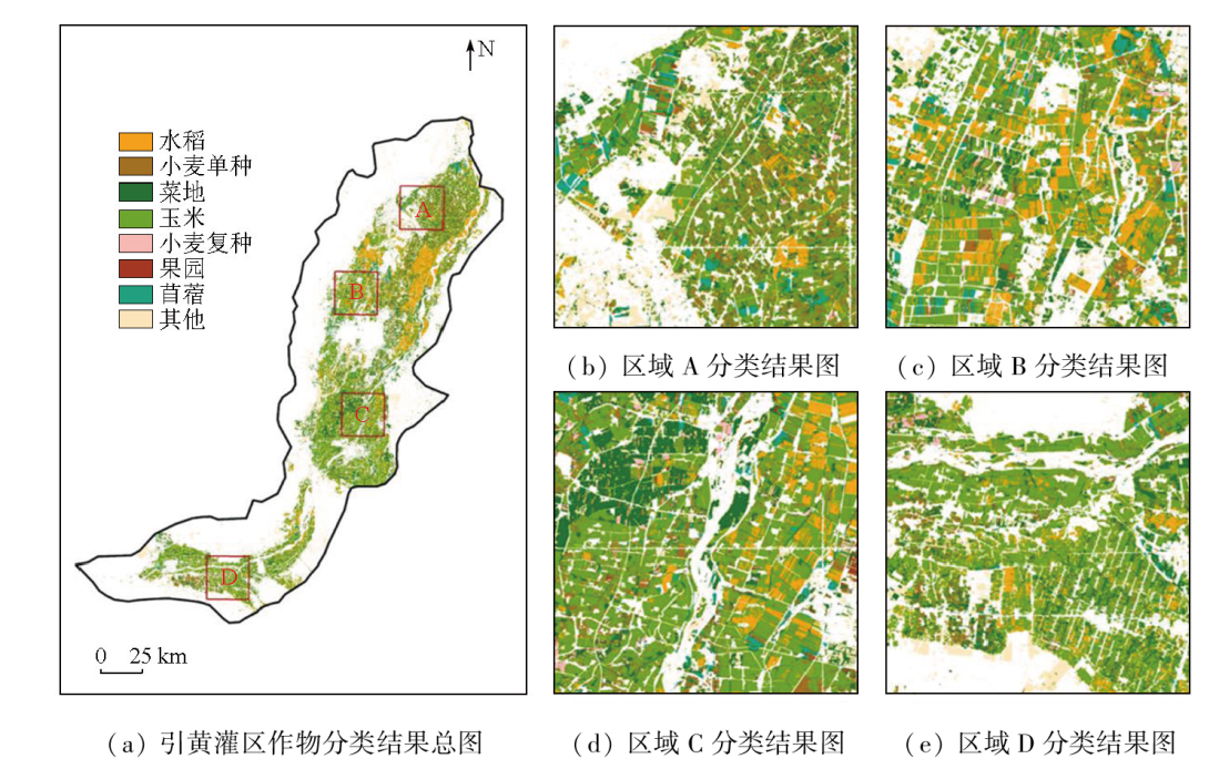
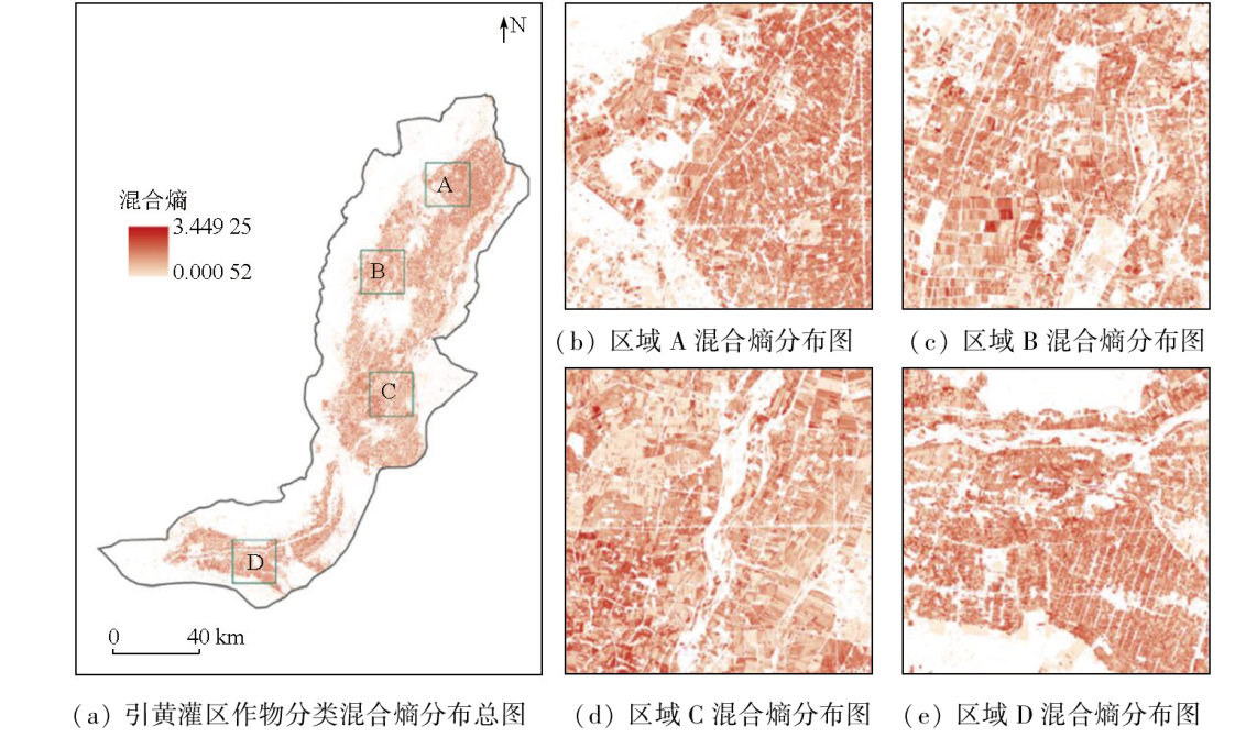
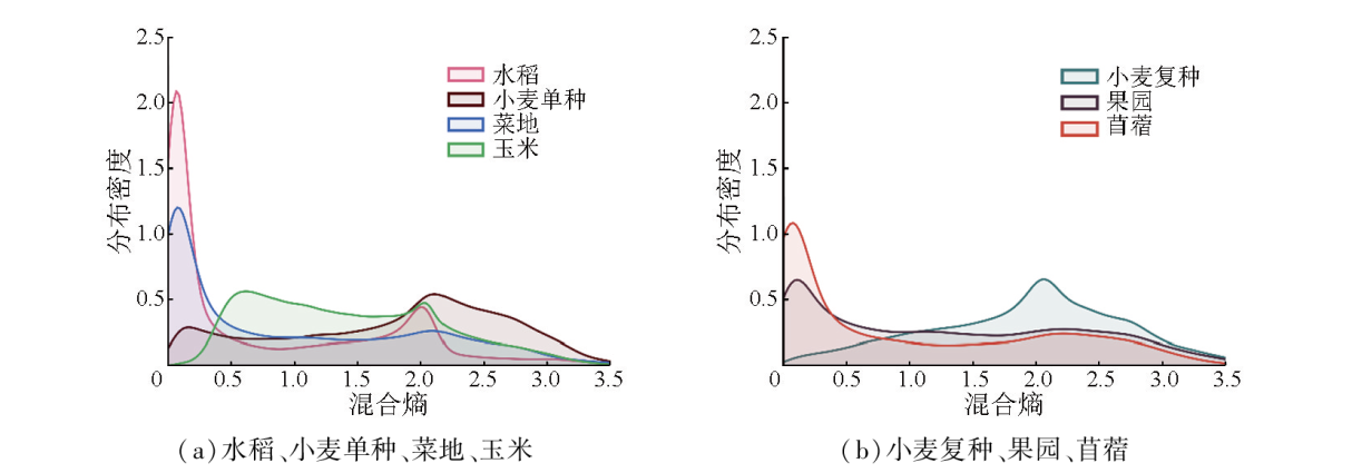
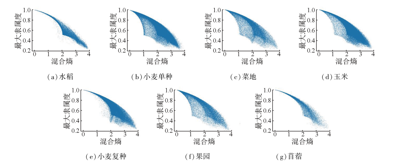
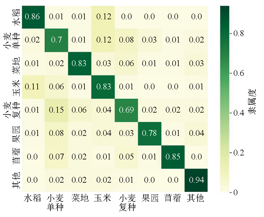
Abstract The rapid survey and accurate mapping of the spatial distribution of crops using remote sensing are fundamental to modern precision agriculture. However, limitations in the acquisition, processing, and analysis of remote sensing images impact the mapping accuracy of traditional crop planting structures. Therefore, there is an urgent need to conduct spatial modeling and feature analysis for the uncertainty in crop classification. Using the Ningxia Yellow River irrigation area as a trial area and farmland parcels as the basic spatial units, this study classified crops on a parcel scale utilizing multi-source remote sensing data and machine learning algorithms. Then, an uncertainty calculation model was constructed based on mixed entropy, yielding the spatial distribution of the uncertainty of crop types in farmland parcels. Afterward, multi-source auxiliary data were employed to build a regression model for the uncertainty, and the potential impacts of related geographical variables on the uncertainty were explored. The experiment results indicate that 1.49 million vector units were constructed for the farmland parcels during the farmland extraction and classification session, yielding an overall crop classification accuracy of 0.80. The mapping results aligned well with the actual agricultural management units, and the classification results proved more better than the traditional pixel-based methods. The uncertainty in the parcel-scale crop classification was generally lower, with significant differences among crop types. The uncertainty was low for rice, vegetable plots, and alfalfa, relatively higher for wheat of single- and double-cropping patterns, and moderate for maize. The uncertainty in parcel-scale crop classification is influenced by various environmental factors such as planting structure and resource conditions, exhibiting the most significant correlations with crop type and water accessibility.
|
| Keywords
remote sensing
crop classification
farmland parcel
uncertainty
machine learning
hybrid entropy
|
|
|
|
Issue Date: 23 December 2024
|
|
|
| [1] |
Weiss M, Jacob F, Duveiller G. Remote sensing for agricultural applications:A meta-review[J]. Remote Sensing of Environment, 2020, 236:111402.
|
| [2] |
吴炳方, 张淼, 曾红伟, 等. 大数据时代的农情监测与预警[J]. 遥感学报, 2016, 20(5):1027-1037.
|
| [2] |
Wu B F, Zhang M, Zeng H W, et al. Agricultural monitoring and early warning in the era of big data[J]. Journal of Remote Sensing, 2016, 20(5):1027-1037.
|
| [3] |
Mitchell P J, Downie A L, Diesing M. How good is my map? A tool for semi-automated thematic mapping and spatially explicit confidence assessment[J]. Environmental Modelling and Software, 2018, 108:111-122.
|
| [4] |
Olofsson P, Foody G M, Herold M, et al. Good practices for estimating area and assessing accuracy of land change[J]. Remote Sensing of Environment, 2014, 148:42-57.
|
| [5] |
陈焕南, 林红燕, 邢海花. 遥感影像数据分类的不确定性分析及其处理方法综述[J]. 现代计算机, 2021, 27(31):33-39.
|
| [5] |
Chen H N, Lin H Y, Xing H H. Review of uncertainty analysis and processing methods of remote sensing image data classification[J]. Modern Computer, 2021, 27(31):33-39.
|
| [6] |
Steele B M, Winne J C, Redmond R L. Estimation and mapping of misclassification probabilities for thematic land cover maps[J]. Remote Sensing of Environment, 1998, 66(2):192-202.
|
| [7] |
Liu J J, Li Z, Qiao Y L, et al. A new method for cross-calibration of two satellite sensors[J]. International Journal of Remote Sensing, 2004, 25(23):5267-5281.
|
| [8] |
Comber A, Fisher P, Brunsdon C, et al. Spatial analysis of remote sensing image classification accuracy[J]. Remote Sensing of Environment, 2012, 127:237-246.
|
| [9] |
Yu Q, Gong P, Tian Y Q, et al. Factors affecting spatial variation of classification uncertainty in an image object-based vegetation mapping[J]. Photogrammetric Engineering and Remote Sensing, 2008, 74(8):1007-1018.
|
| [10] |
柏延臣, 王劲峰. 遥感数据专题分类不确定性评价研究:进展、问题与展望[J]. 地球科学进展, 2005, 20(11):1218-1225.
doi: 10.11867/j.issn.1001-8166.2005.11.1218
|
| [10] |
Bo Y C, Wang J F. Assessment on uncertainty in remotely sensed data classification:Progresses,problems and prospects[J]. Advance in Earth Sciences, 2005, 20(11):1218-1225.
|
| [11] |
郭逸飞, 吴田军, 骆剑承, 等. 基于不确定性迭代优化的山地植被遥感制图[J]. 地球信息科学学报, 2022, 24(7):1406-1419.
doi: 10.12082/dqxxkx.2022.210594
|
| [11] |
Guo Y F, Wu T J, Luo J C, et al. Remote sensing mapping of mountain vegetation via uncertainty-based iterative optimization[J]. Journal of Geo-Information Science, 2022, 24(7):1406-1419.
|
| [12] |
Lyons M B, Keith D A, Phinn S R, et al. A comparison of resampling methods for remote sensing classification and accuracy assessment[J]. Remote Sensing of Environment, 2018, 208:145-153.
|
| [13] |
Goodchild M F, Sun G, Yang S. Development and test of an error model for categorical data[J]. International Journal of Geographical Information Systems, 1992, 6(2):87-103.
|
| [14] |
Brown K M, Foody G M, Atkinson P M. Estimating per-pixel thematic uncertainty in remote sensing classifications[J]. International Journal of Remote Sensing, 2009, 30(1):209-229.
|
| [15] |
Comber A J. Geographically weighted methods for estimating local surfaces of overall,user and producer accuracies[J]. Remote Sensing Letters, 2013, 4(4):373-380.
|
| [16] |
Khatami R, Mountrakis G, Stehman S V. Mapping per-pixel predicted accuracy of classified remote sensing images[J]. Remote Sen-sing of Environment, 2017, 191:156-167.
|
| [17] |
Immitzer M, Vuolo F, Atzberger C. First experience with sentinel-2 data for crop and tree species classifications in central Europe[J]. Remote Sensing, 2016, 8(3):166.
|
| [18] |
孙营伟. 复杂成像条件下地块级作物种植结构遥感制图研究[D]. 北京: 中国科学院大学, 2020.
|
| [18] |
Sun Y W. Study on remote sensing mapping of plot-level crop planting structure under complex imaging conditions[D]. Beijing: University of Chinese Academy of Sciences, 2020.
|
| [19] |
Liu Y, Cheng M M, Hu X, et al. Richer convolutional features for edge detection[J]. IEEE Transactions on Pattern Analysis and Machine Intelligence, 2019, 41(8):1939-1946.
doi: 10.1109/TPAMI.2018.2878849
pmid: 30387723
|
| [20] |
刘巍. 多源遥感协同的西南山地区耕地信息提取方法研究[D]. 北京: 中国科学院大学, 2021.
|
| [20] |
Liu W. Study on extraction method of cultivated land information in southwest mountainous area by multi-source remote sensing colla-boration[D]. Beijing: University of Chinese Academy of Sciences, 2021.
|
| [21] |
Hochreiter S, Schmidhuber J. Long short-term memory[J]. Neural Computation, 1997, 9(8):1735-1780.
doi: 10.1162/neco.1997.9.8.1735
pmid: 9377276
|
| [22] |
徐慧. 遥感影像不确定性对分类结果可靠性影响模式研究[D]. 武汉: 武汉大学, 2020.
|
| [22] |
Xu H. Exploration of the influence model remote sensing image uncertainty on classification[D]. Wuhan: Wuhan University, 2020.
|
| [23] |
Shannon C E. A mathematical theory of communication[J]. The Bell System Technical Journal, 1948, 27(3):379-423.
|
| [24] |
吴浩, 程志萍, 史文中, 等. 遥感云分类不确定性的多维混合熵模型评价[J]. 测绘科学, 2016, 41(5):50-54,176.
|
| [24] |
Wu H, Cheng Z P, Shi W Z, et al. Evaluation on uncertainty of RS cloud classification based on multidimensional hybrid entropy mo-del[J]. Science of Surveying and Mapping, 2016, 41(5):50-54,176.
|
| [25] |
刘艳芳, 兰泽英, 刘洋, 等. 基于混合熵模型的遥感分类不确定性的多尺度评价方法研究[J]. 测绘学报, 2009, 38(1):82-87.
|
| [25] |
Liu Y F, Lan Z Y, Liu Y, et al. Multi-scale evaluation method for uncertainty of remote sensing classification based on hybrid entropy model[J]. Acta Geodaetica et Cartographica Sinica, 2009, 38(1):82-87.
|
| [26] |
Smith J H, Stehman S V, Wickham J D, et al. Effects of landscape characteristics on land-cover class accuracy[J]. Remote Sensing of Environment, 2003, 84(3):342-349.
|
| [27] |
Ortiz A, Oliver G. On the use of the overlapping area matrix for ima-ge segmentation evaluation:A survey and new performance measures[J]. Pattern Recognition Letters, 2006, 27(16):1916-1926.
|
| [28] |
Foody G M. Status of land cover classification accuracy assessment[J]. Remote Sensing of Environment, 2002, 80(1):185-201.
|
| [29] |
Grömping U. Variable importance assessment in regression:Linear regression versus random forest[J]. The American Statistician, 2009, 63(4):308-319.
|
| [30] |
Löw F, Michel U, Dech S, et al. Impact of feature selection on the accuracy and spatial uncertainty of per-field crop classification using support vector machines[J]. ISPRS Journal of Photogrammetry and Remote Sensing, 2013, 85:102-119.
|
|
Viewed |
|
|
|
Full text
|
|
|
|
|
Abstract
|
|
|
|
|
Cited |
|
|
|
|
| |
Shared |
|
|
|
|
| |
Discussed |
|
|
|
|
 2024,
Vol. 36
2024,
Vol. 36