|
|
 |
|

|
|
|
Hazard assessment of potential glacial lake outburst floods in the Yadong River basin based on multisource satellite data |
ZHU Dengxin1,2,3( ), TU Jienan1(), SUN Haibing1,2, HAN Zhenjie1,2, TONG Liqiang1, GUO Zhaocheng1, YU Jiangkuan1, YAN Shuhao1, HE Peng1, ZHU Junjie4 ), TU Jienan1(), SUN Haibing1,2, HAN Zhenjie1,2, TONG Liqiang1, GUO Zhaocheng1, YU Jiangkuan1, YAN Shuhao1, HE Peng1, ZHU Junjie4 |
1. China Aero Geophysical and Remote Sensing Center of Natural Resources, Beijing 100083, China
2. College of Engineering and Technology, China University of Geosciences(Beijing), Beijing 100083, China
3. Yellow River Engineering Consulting Co., Ltd., Zhengzhou 450003, China
4. Yellow River Mudan Bureau, Heze 274009, China |
|
|
|
|
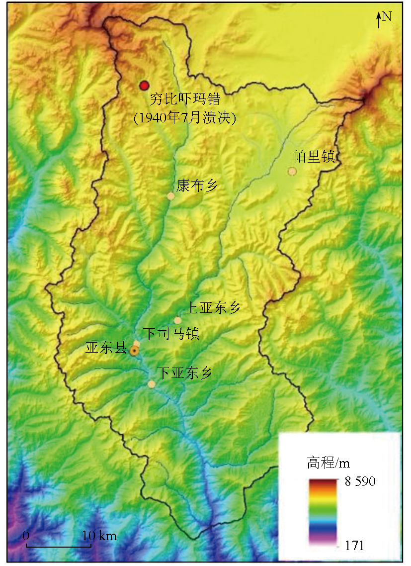
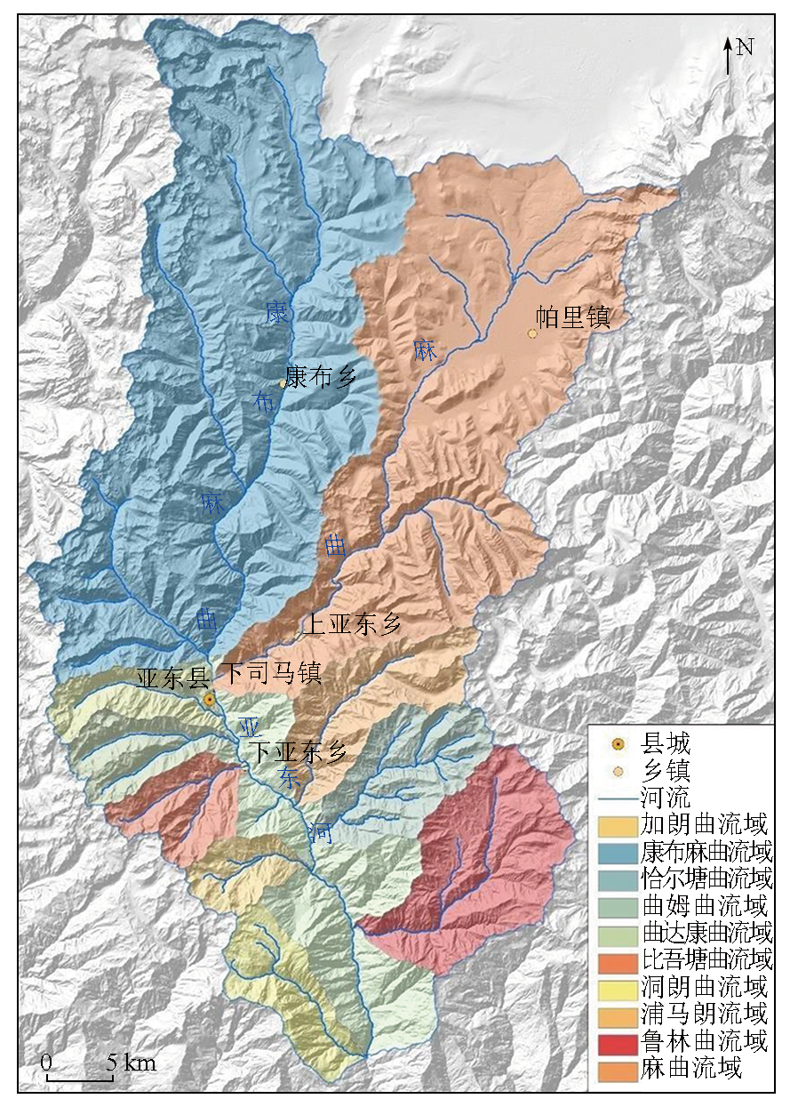
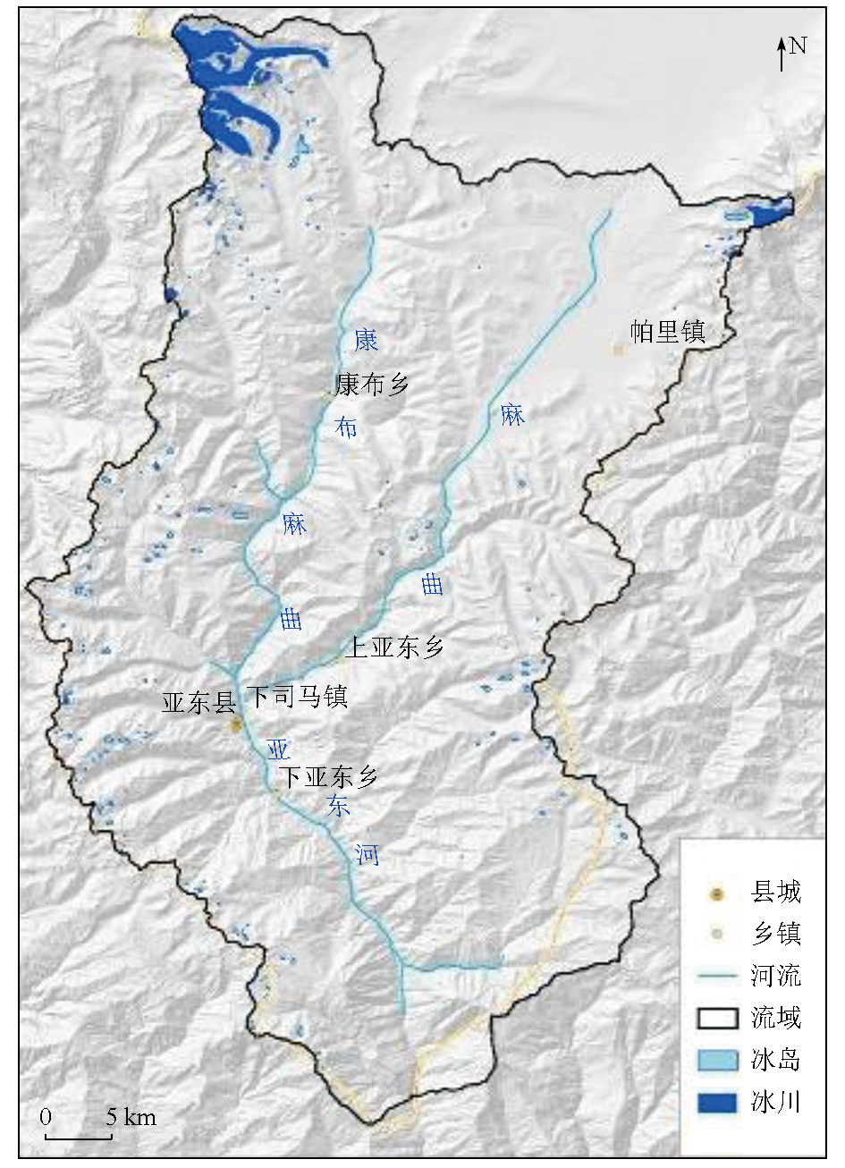
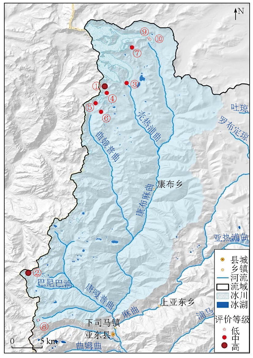
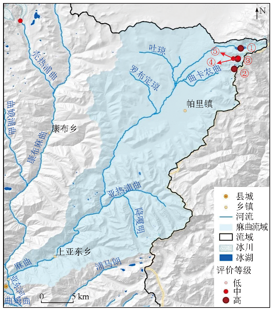
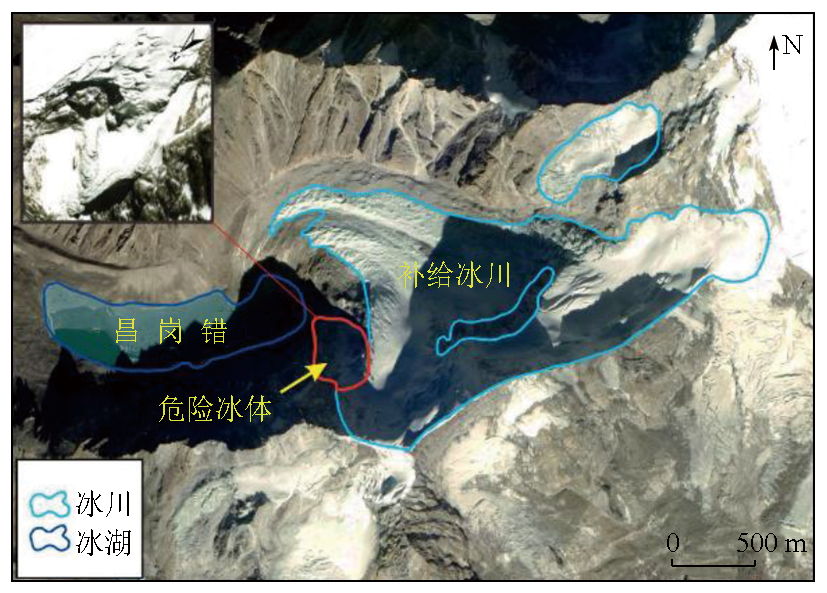
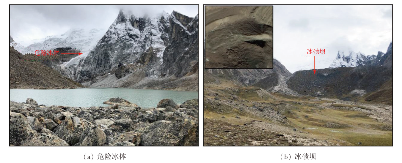
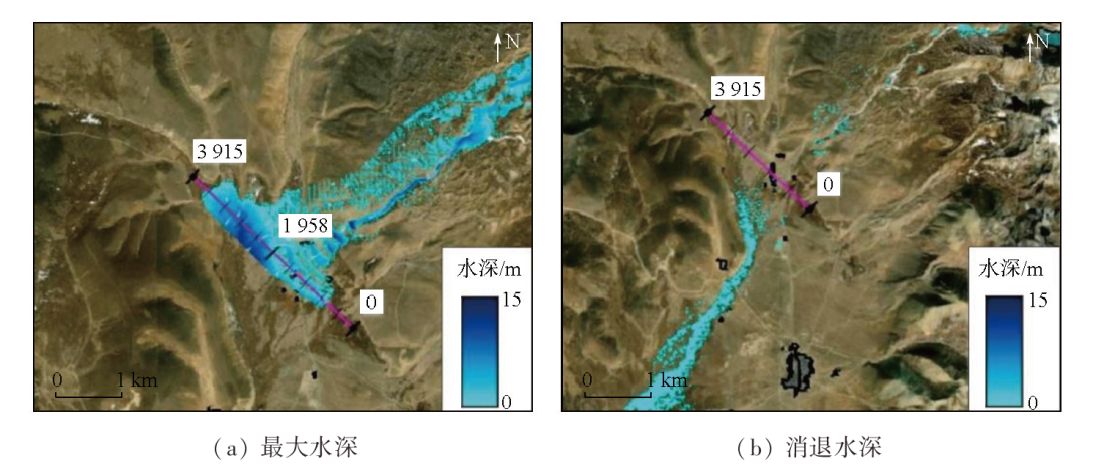
Abstract In recent years, global warming has caused significant glacier retreats in the Qinghai-Tibet Plateau, leading to the rapid expansion of glacial lakes and an increased threat of glacial lake outburst floods (GLOFs). The Yadong River basin, located in Shigatse, Tibet, hosts a large number of glacial lakes. In 1940, a GLOF from Qiongbixiama Co severely damaged Yadong County 40 km downstream, causing house collapse and infrastructure destruction. Therefore, assessing the hazards of potential GLOSs in the Yadong River basin is vital for protecting the safety of people’s lives and property. This study conducted a survey and assessment of potential GLOFs based on Gaofen satellite data and Landsat remote sensing images. It derived basic elements including glaciers, glacial lakes, and moraines through remote sensing image interpretation. The results show that the Yadong River basin develops 28 glaciers and 228 glacial lakes, covering total areas of 34.03 km2 and 7.79 km2, respectively. The past 30 years have seen slight retreats of glaciers and slight expansions of glacial lakes. Combined with the elements derived from remote sensing images, the analytic hierarchy process and fuzzy comprehensive assessment were employed to preliminarily assess the hazard of regional glacial lakes, delineating the distribution of potentially hazardous glacial lakes. The assessment results reveal 15 potentially hazardous glacial lakes in the Yadong River basin, including five highly hazardous, eight moderately hazardous, and two slightly hazardous glacial lakes. These lakes are primarily distributed in the northeastern and northwestern high mountain areas in the Yadong River basin.
|
| Keywords
glacial lake outburst flood
remote sensing
hazard assessment
Yadong River basin
|
|
|
|
Issue Date: 09 May 2025
|
|
|
| [1] |
Maurer J M, Schaefer J M, Rupper S, et al. Acceleration of ice loss across the Himalayas over the past 40 years[J]. Science Advances, 2019, 5(6): eaav7266.
|
| [2] |
余斌, 何元勋, 刘秧. 冰碛湖溃决易发性的定量评价[J]. 地球科学, 2022, 47(6):1999-2014.
|
| [2] |
Yu B, He Y X, Liu Y. Quantitative susceptibility assessment of breach of moraine-dammed lakes[J]. Earth Science, 2022, 47(6):1999-2014.
|
| [3] |
张太刚, 王伟财, 高坛光, 等. 亚洲高山区冰湖溃决洪水事件回顾[J]. 冰川冻土, 2021, 43(6): 1673-1692.
doi: 10.7522/j.issn.1000-0240.2021.0066
|
| [3] |
Zhang T G, Wang W C, Gao T G, et al. Glacial lake outburst floods on the high Mountain Asia: A review[J]. Journal of Glaciology and Geocryology, 2021, 43(6):1673-1692.
|
| [4] |
杨兴国, 曹志翔, 邢会歌, 等. 冰碛土滑坡—泥石流—堰塞湖灾害链发展过程机理与模拟技术研究构想[J]. 工程科学与技术, 2022, 54(3): 1-13.
|
| [4] |
Yang X G, Cao Z X, Xing H G, et al. Research framework of the program: Dynamic evolution mechanism and simulation of moraine landslide—debris flow—dammed lake disaster chain[J]. Advanced Engineering Sciences, 2022, 54(3):1-13.
|
| [5] |
王欣, 刘时银, 姚晓军, 等. 我国喜马拉雅山区冰湖遥感调查与编目[J]. 地理学报, 2010, 65(1):29-36.
|
| [5] |
Wang X, Liu S Y, Yao X J, et al. Glacier lake investigation and inventory in the Chinese Himalayas based on the remote sensing data[J]. Acta Geographica Sinica, 2010, 65(1):29-36.
doi: 10.11821/xb201001004
|
| [6] |
程尊兰, 朱平一, 宫怡文. 典型冰湖溃决型泥石流形成机制分析[J]. 山地学报, 2003, 21(6):716-720.
|
| [6] |
Cheng Z L, Zhu P Y, Gong Y W. Typical debris flow triggered by ice-lake break[J]. Journal of Mountain Research, 2003, 21(6):716-720.
|
| [7] |
Zhang G Q, Yao T D, Xie H J, et al. An inventory of glacial lakes in the Third Pole region and their changes in response to global warming[J]. Global and Planetary Change, 2015, 131:148-157.
|
| [8] |
Zheng G X, Allen S K, Bao A, et al. Increasing risk of glacial lake outburst floods from future Third Pole deglaciation[J]. Nature Climate Change, 2021, 11(5): 411-417.
|
| [9] |
王欣, 刘时银, 郭万钦, 等. 我国喜马拉雅山区冰碛湖溃决危险性评价[J]. 地理学报, 2009, 64(7): 782-790.
|
| [9] |
Wang X, Liu S Y, Guo W Q, et al. Hazard assessment of moraine-dammed lake outburst floods in the Himalayas,China[J]. Acta Geographica Sinica, 2009, 64(7):782-790.
|
| [10] |
车涛, 晋锐, 李新, 等. 近 20 a来西藏朋曲流域冰湖变化及潜在溃决冰湖分析[J]. 冰川冻土, 2004, 26(4):397-402.
|
| [10] |
Che T, Jin R, Li X, et al. Glacial lakes variation and the potentially dangerous glacial lakes in the Pumqu Basin of Tibet during the last two decades[J]. Journal of Glaciology and Geocryology, 2004, 26(4):397-402.
|
| [11] |
王跃, 安天浩. 典型冰湖溃决泥石流成因分析及危险性评价体系探讨[J]. 矿产勘查, 2018, 9(4):727-731.
|
| [11] |
Wang Y, An T H. Discussion on causes analysis and risk assessment system the typical glacial lake outburst debris flow[J]. Mineral Exploration, 2018, 9(4):727-731.
|
| [12] |
刘建康, 张佳佳, 高波, 等. 我国西藏地区冰湖溃决灾害综述[J]. 冰川冻土, 2019, 41(6): 1335-1347.
doi: 10.7522/j.issn.1000-0240.2019.0073
|
| [12] |
Liu J K, Zhang J J, Gao B, et al. An overview of glacial lake outburst flood in Tibet,China[J]. Journal of Glaciology and Geocryology, 2019, 41(6):1335-1347.
|
| [13] |
周路旭, 刘建康, 李元灵. 川藏交通廊道龙利空泽错冰碛湖溃决危险性评价[J]. 地理与地理信息科学, 2020, 36(6):32-39,47.
|
| [13] |
Zhou L X, Liu J K, Li Y L. Outburst risk assessment of Longlikongze Moraine Lake in Sichuan-Tibet traffic corridor[J]. Geography and Geo-Information Science, 2020, 36(6):32-39,47.
|
| [14] |
乐茂华, 唐川, 张丹丹, 等. 基于逻辑回归法的西藏地区冰湖溃决危险性预测模型[J]. 自然灾害学报, 2014, 23(5): 177-184.
|
| [14] |
Le M H, Tang C, Zhang D D, et al. Logistic regression model- based approach for predicting the hazard of glacial lake outburst in Tibet[J]. Journal of Natural Disasters, 2014, 23(5):177-184.
|
| [15] |
Richardson S D, Reynolds J M. An overview of glacial hazards in the Himalayas[J]. Quaternary International, 2000, 65:31-47.
|
| [16] |
亚东县人民政府. 亚东县概况[EB/OL]. [2021-06-23] http://www.ydx.gov.cn/news-detail.thtml?cid=136260.
url: http://www.ydx.gov.cn/news-detail.thtml?cid=136260
|
| [16] |
Yadong County People's Government. Overview of Yadong County[EB/OL]. [2021-06-23] http://www.ydx.gov.cn/news-detail.thtml?cid=136260.
url: http://www.ydx.gov.cn/news-detail.thtml?cid=136260
|
| [17] |
童立强, 祁生文, 安国英, 等. 喜马拉雅山地区重大地质灾害遥感调查研究[M]. 北京: 科学出版社, 2013:116.
|
| [17] |
Tong L Q, Qi S W, An G Y, et al. Remote sensing investigation of major geological disasters in Himalayan region[M]. Beijing: Science Press, 2013:116.
|
| [18] |
刘时银, 姚晓军, 郭万钦, 等. 基于第二次冰川编目的中国冰川现状[J]. 地理学报, 2015, 70(1):3-16.
doi: 10.11821/dlxb201501001
|
| [18] |
Liu S Y, Yao X J, Guo W Q, et al. The contemporary glaciers in China based on the second Chinese glacier inventory[J]. Acta Geographica Sinica, 2015, 70(1):3-16.
doi: 10.11821/dlxb201501001
|
| [19] |
姚晓军, 刘时银, 韩磊, 等. 冰湖的界定与分类体系——面向冰湖编目和冰湖灾害研究[J]. 地理学报, 2017, 72(7):1173-1183.
doi: 10.11821/dlxb201707004
|
| [19] |
Yao X J, Liu S Y, Han L, et al. Definition and classification systems of glacial lake for inventory and hazards study[J]. Acta Geographica Sinica, 2017, 72(7):1173-1183.
doi: 10.11821/dlxb201707004
|
| [20] |
王世金, 汪宙峰. 冰湖溃决灾害综合风险评估与管控:以中国喜马拉雅山区为例[M]. 北京: 中国社会科学出版社, 2017: 91-95.
|
| [20] |
Wang S J, Wang Z F. Comprehensive risk assessment and control of glacial lake outburst disaster:A case study of Himalayan Mountain area in China[M]. Beijing: China Social Sciences Press, 2017: 91-95.
|
| [21] |
陈晓清, 崔鹏, 杨忠, 等. 近15 a喜玛拉雅山中段波曲流域冰川和冰湖变化[J]. 冰川冻土, 2005, 27(6):793-800.
|
| [21] |
Chen X Q, Cui P, Yang Z, et al. Change in glaciers and glacier lakes in Boiqu River basin,middle Himalayas during last 15 years[J]. Journal of Glaciology and Geocryology, 2005, 27(6):793-800.
|
| [22] |
范建容, 李炫, 游勇, 等. 川藏铁路然乌—通麦段冰湖溃决危险性模糊综合评价及应用[C]// “川藏铁路建设的挑战与对策”2016 学术交流会论文集.中国科学院水利部成都山地灾害与环境研究所, 2016.
|
| [22] |
Fan J R, Li X, You Y, et al. Fuzzy comprehensive assessment of glacier-lake outburst from Ranwu to Tongmai along Sichuan-Tibet railway[C]// "Challenges and Countermeasures of Sichuan-Tibet Railway Construction" Proceedings of 2016 Academic Exchange Conference.Institute of Mountain Hazards and Environment,Chinese Academy of Sciences, 2016.
|
| [23] |
崔志超, 王俊豪, 崔传峰, 等. 基于层次分析法和模糊数学相结合的甘肃东乡八丹沟泥石流易发性评价[J]. 中国地质灾害与防治学报, 2020, 31(1):44-50.
|
| [23] |
Cui Z C, Wang J H, Cui C F, et al. Evaluation of the susceptibility of debris flow in Badan Gully of Dongxiang County of Gansu based on AHP and fuzzy mathematics[J]. The Chinese Journal of Geological Hazard and Control, 2020, 31(1):44-50.
|
|
Viewed |
|
|
|
Full text
|
|
|
|
|
Abstract
|
|
|
|
|
Cited |
|
|
|
|
| |
Shared |
|
|
|
|
| |
Discussed |
|
|
|
|
 2025,
Vol. 37
2025,
Vol. 37