|
|
 |
|

|
|
|
Subpixel-level area estimation of green algae based on spectral unmixing in dictionary learning |
ZHANG Yiran1( ), PAN Bin1(), XU Xia2, ZHU Junfeng3 ), PAN Bin1(), XU Xia2, ZHU Junfeng3 |
1. College of Statistics and Data Science, Nankai University, Tianjin 300071, China
2. College of Computer Science, Nankai University, Tianjin 300071, China
3. Autobio Labtec Instruments Co., Ltd., Zhengzhou 450016, China |
|
|
|
|
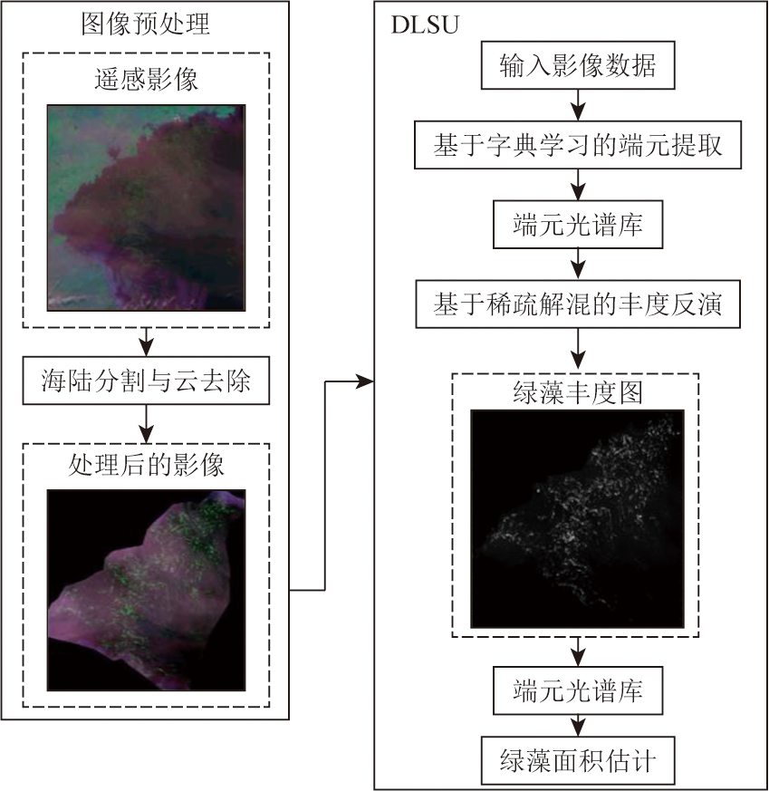
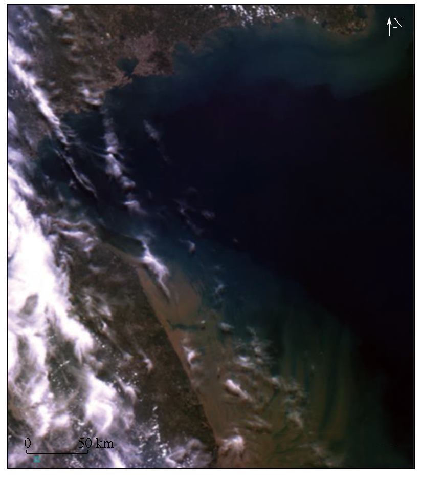
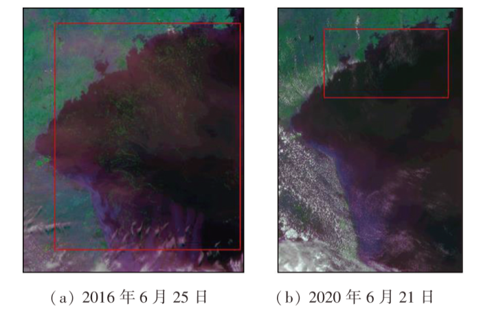
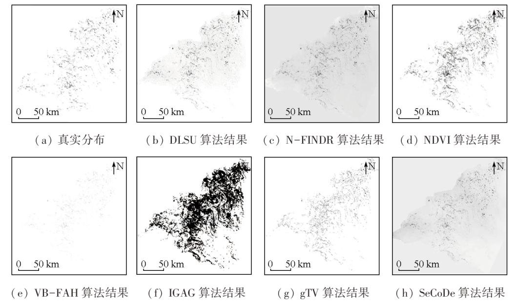
Abstract Green tides have emerged as a significant marine ecological disaster worldwide, rendering the accurate detection and area estimation of green algae crucial. To accurately estimate the coverage area of green algae communities in the monitoring of green tides based on low-resolution satellite images, this study proposed a dictionary learning-based method for estimating the area of green algae using hyperspectral images. The proposed method involves deriving the endmember spectrum database that is closest to the unknown surface feature spectra via online robust dictionary learning, obtaining the abundance map of green algae through sparse coding, and calculating the coverage area of green algae. It was verified through the experiment using the spectral images acquired by the geostationary ocean color imager (GOCI) on June 25, 2016, and June 21, 2020. The experimental results reveal that the calculated coverage areas of green algae on the two days were highly close to the approximate measured results, with a minimum error of only 2.15 %, suggesting that the proposed method outperforms traditional index-based hard thresholding algorithms. Independent of the pure pixel hypothesis, the proposed method can effectively address the mixed pixel problem and enhance area estimation accuracy in the absence of a pre-estimated number of endmembers or prior spectral information, thereby achieving high-precision subpixel-level area estimation of green algae.
|
| Keywords
hyperspectral image
sparse unmixing
detection of green algae
area estimation
surface feature extraction
|
|
|
|
Issue Date: 09 May 2025
|
|
|
| [1] |
王广策, 王辉, 高山, 等. 绿潮生物学机制研究[J]. 海洋与湖沼, 2020, 51(4):789-808.
|
| [1] |
Wang G C, Wang H, Gao S, et al. Study on the biological mechanism of green tide[J]. Oceanologia et Limnologia Sinica, 2020, 51(4):789-808.
|
| [2] |
王宗灵, 傅明珠, 肖洁, 等. 黄海浒苔绿潮研究进展[J]. 海洋学报, 2018, 40(2):1-13.
|
| [2] |
Wang Z L, Fu M Z, Xiao J, et al. Progress on the study of the Yellow Sea green tides caused by Ulva prolifera[J]. Haiyang Xuebao, 2018, 40(2):1-13.
|
| [3] |
Hu L, Zeng K, Hu C, et al. On the remote estimation of Ulva prolifera areal coverage and biomass[J]. Remote Sensing of Environment, 2019, 223:194-207.
|
| [4] |
Hu C. A novel ocean color index to detect floating algae in the global oceans[J]. Remote Sensing of Environment, 2009, 113(10):2118-2129.
|
| [5] |
Xing Q, Hu C. Mapping macroalgal blooms in the Yellow Sea and East China Sea using HJ-1 and Landsat data:Application of a virtual baseline reflectance height technique[J]. Remote Sensing of Environment, 2016, 178:113-126.
|
| [6] |
刘锦超, 刘建强, 丁静, 等. HY-1C卫星CZI载荷的黄海绿潮提取研究[J]. 海洋学报, 2022, 44(5):1-11.
|
| [6] |
Liu J C, Liu J L, Ding J, et al. A refined imagery algorithm to extract green tide in the Yellow Sea from HY-1C satellite CZI measurements[J]. Haiyang Xuebao, 2022, 44(5):1-11.
|
| [7] |
Hu C, Qi L, Hu L, et al. Mapping Ulva prolifera green tides from space:A revisit on algorithm design and data products[J]. International Journal of Applied Earth Observation and Geoinformation, 2023, 116:103173.
|
| [8] |
赵尊强, 陈鑫, 刘慧芳, 等. 基于改进FCN网络的GOCI绿潮分类研究[J]. 软件导刊, 2020, 19(3):69-73.
|
| [8] |
Zhao Z Q, Chen X, Liu H F, et al. Greentide classification for GOCI based on improved FCN network[J]. Software Guide, 2020, 19(3):69-73.
|
| [9] |
潘斌, 张宁, 史振威, 等. 基于高光谱图像解混的海洋绿藻检测算法[J]. 红外与激光工程, 2018, 47(8):0823001.
|
| [9] |
Pan B, Zhang N, Shi Z W, et al. Green algae dectection algorithm based on hyperspectral image unmixing[J]. Infrared and Laser Engineering, 2018, 47(8):0823001.
|
| [10] |
Winter M E. N-FINDR:An algorithm for fast autonomous spectral end-member determination in hyperspectral data[C]// // Spies International Symposium on Optical Science.International Society for Optics and Photonics, 1999.
|
| [11] |
Xiao Y, Zhang J, Cui T. High-precision extraction of nearshore green tides using satellite remote sensing data of the Yellow Sea,China[J]. International Journal of Remote Sensing, 2017, 38(6):1626-1641.
|
| [12] |
Pan B, Shi Z, An Z, et al. A novel spectral-unmixing-based green algae area estimation method for GOCI data[J]. IEEE Journal of Selected Topics in Applied Earth Observations and Remote Sensing, 2017, 10(2):437-449.
|
| [13] |
Tao X, Cui T, Ren P. Cofactor-based efficient endmember extraction for green algae area estimation[J]. IEEE Geoscience and Remote Sensing Letters, 2019, 16(6):849-853.
|
| [14] |
Alba G, Anabella F, Marcelo S C, et al. Multitemporal spectral analysis for algae detection in an eutrophic lake using sentinel 2 images[C]// 2020 IEEE Latin American GRSS & ISPRS Remote Sensing Conference (LAGIRS).March 22-26, Santiago,Chile.IEEE, 2020:351-356.
|
| [15] |
Thouvenin P A, Dobigeon N, Tourneret J Y. Online unmixing of multitemporal hyperspectral images accounting for spectral variability[J]. IEEE Transactions on Image Processing, 2016, 25(9):3979-3990.
|
| [16] |
Iordache M D, Plaza A, Bioucas-Dias J. Recent developments in sparse hyperspectral unmixing[C]// 2010 IEEE International Geoscience and Remote Sensing Symposium.July 25-30, Honolulu,HI,USA.IEEE, 2010:1281-1284.
|
| [17] |
宋晓瑞, 赵忠文, 于尧. 一种在线字典学习的高光谱图像盲解混方法[J]. 装备学院学报, 2017, 28(3):21-26.
|
| [17] |
Song X R, Zhao Z W, Yu Y. Blind unmixing of hyperspectral images based on online dictionary learning[J]. Journal of Equipment Academy, 2017, 28(3):21-26.
|
| [18] |
Lu C, Shi J, Jia J. Online robust dictionary learning[C]// 2013 IEEE Conference on Computer Vision and Pattern Recognition.June 23-28,2013, Portland,OR,USA.IEEE, 2013:415-422.
|
| [19] |
Bioucas-Dias J M, Figueiredo M A T. Alternating direction algorithms for constrained sparse regression:Application to hyperspectral unmixing[C]// 2010 2nd Workshop on Hyperspectral Image and Signal Processing:Evolution in Remote Sensing. June 14-16,2010, Reykjavik,Iceland.IEEE, 2010:1-4.
|
| [20] |
Zhao C, Wang X, Cham W K. Background subtraction via robust dictionary learning[J]. EURASIP Journal on Image and Video Processing, 2011, 2011(1):972961.
|
| [21] |
Wagner A, Wright J, Ganesh A, et al. Toward a practical face recognition system:Robust alignment and illumination by sparse representation[J]. IEEE Transactions on Pattern Analysis and Machine Intelligence, 2012, 34(2):372-386.
|
| [22] |
Jin X, Wan J, Hu W, et al. Retrieval of green tide concentration and interannual variation analysis in Yellow Sea based on multi-source remote sensing monitoring[C]// Global Oceans 2020:Singapore - U.S.Gulf Coast. October 5-30,2020, Biloxi,MS,USA.IEEE, 2020:1-5.
|
| [23] |
童旭东. 中国高分辨率对地观测系统重大专项建设进展[J]. 遥感学报, 2016, 20(5):775-780.
|
| [23] |
Tong X D. Development of China high-resolution earth observation system[J]. Journal of Remote Sensing, 2016, 20(5):775-780.
|
| [24] |
胡昌苗, 白洋, 唐娉. GF-4序列图像的云自动检测[J]. 遥感学报, 2018, 22(1):132-142.
|
| [24] |
Hu C M, Bai Y, Tang P. Automatic cloud detection for GF-4 series images[J]. Journal of Remote Sensing, 2018, 22(1):132-142.
|
| [25] |
Qin J, Lee H, Chi J T, et al. Blind hyperspectral unmixing based on graph total variation regularization[J]. IEEE Transactions on Geoscience and Remote Sensing, 2021, 59(4):3338-3351.
|
| [26] |
Yao J, Hong D, Xu L, et al. Sparsity-enhanced convolutional decomposition:A novel tensor-based paradigm for blind hyperspectral unmixing[J]. IEEE Transactions on Geoscience and Remote Sensing, 2021, 60:5505014.
|
|
Viewed |
|
|
|
Full text
|
|
|
|
|
Abstract
|
|
|
|
|
Cited |
|
|
|
|
| |
Shared |
|
|
|
|
| |
Discussed |
|
|
|
|
 2025,
Vol. 37
2025,
Vol. 37