|
|
 |
|

|
|
|
Deformation monitoring using time-series InSAR with dual-polarization optimization |
XUAN Jiabin1( ), LI Ruren1, FU Wenxue2,3() ), LI Ruren1, FU Wenxue2,3() |
1. School of Transportation and Geomatics Engineering, Shenyang Jianzhu University, Shenyang 110168, China
2. Key Laboratory of Digital Earth Science, Aerospace Information Research Institute, Chinese Academy of Sciences, Beijing 100094, China
3. International Research Center of Big Data for Sustainable Development Goals, Beijing 100094, China |
|
|
|
|
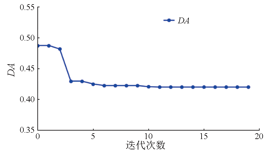
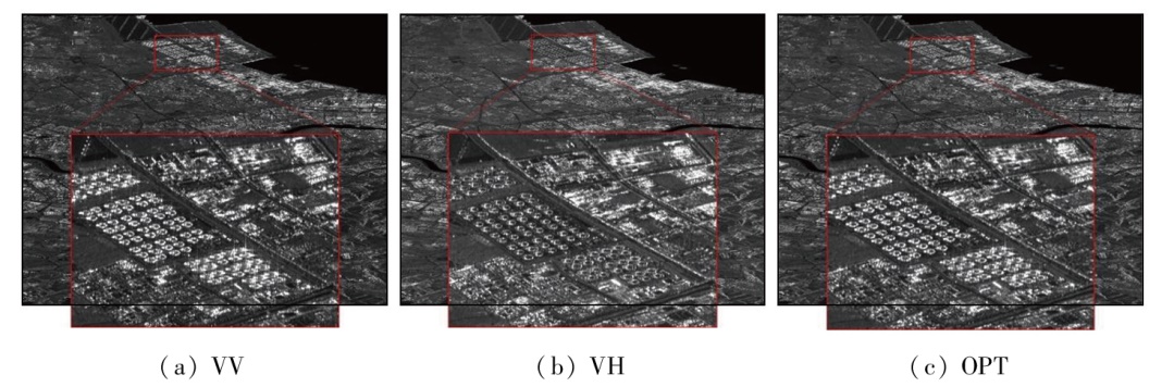
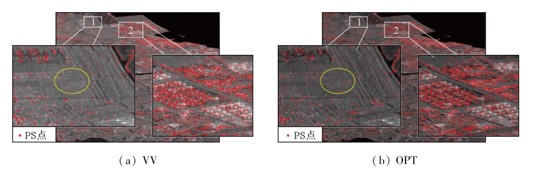
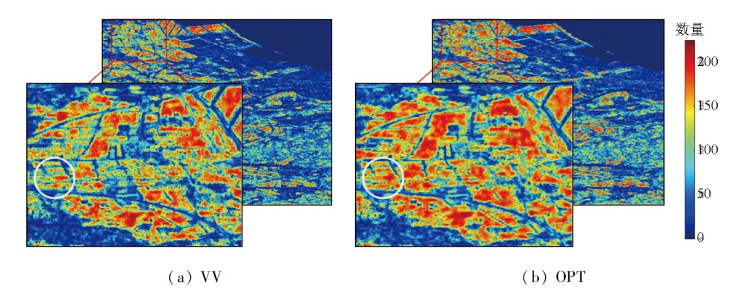
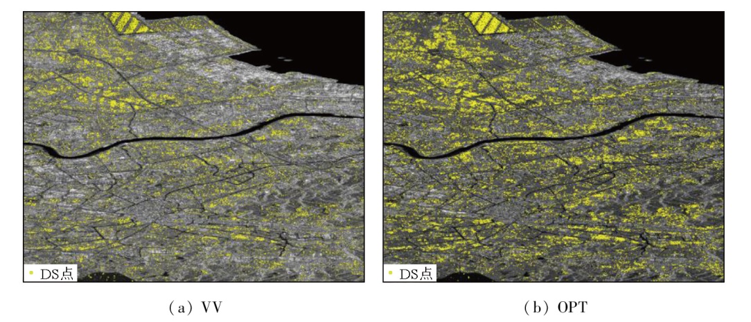
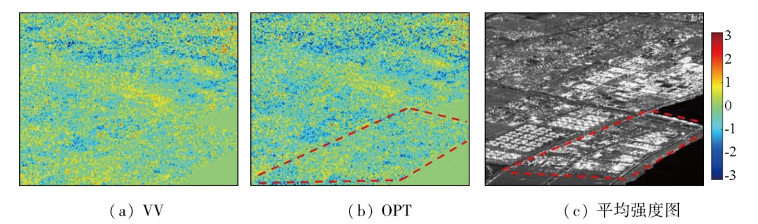
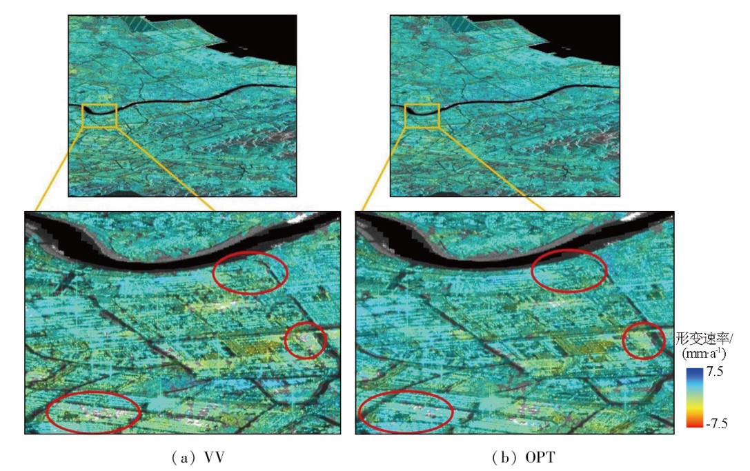
Abstract The spatial density and interferometric phase quality of high-quality monitoring points serve as key indicators for deformation monitoring using the time-series interferometric synthetic aperture radar (InSAR) technique. To further enhance the deformation monitoring ability of the InSAR technique for non-urban areas, this study proposed a polarization time-series InSAR method that takes into account distributed scatterers (DSs) using dual-polarization images from Sentinel-1. Specifically, polarization processing of the intensity and phase information of time-series SAR data was conducted using various methods based on the characteristics of DSs and taking the dispersion of amplitude (DA) as an indicator for the phase quality assessment. Then, surface deformation monitoring was performed using the data before and after optimization. This study carried out experiments on Ningbo City in Zhejiang Province using 40 scenes of dual-polarization (VV-VH) images from Sentinel-1. The results indicate that the proposed method can significantly increase the density of monitoring points and the interferometric phase quality. Compared to single polarization, the proposed method increased the quantities of persistent scatterers (PSs) and DSs by about 20% and 57.5%, respectively. Furthermore, the interferometric phase quality was also significantly improved, with the average coherence increasing by more than 15%. The proposed method allows for a more detailed reflection of regional deformations.
|
| Keywords
polarization time-series InSAR technique
dual-polarization images from Sentinel-1
deformation monitoring of complex terrain
|
|
|
|
Issue Date: 31 December 2025
|
|
|
| [1] |
Zhu C H, Wang C S, Zhang B C, et al. Differential interferometric synthetic aperture radar data for more accurate earthquake catalogs[J]. Remote Sensing of Environment, 2021,266:112690.
|
| [2] |
Cigna F, Tapete D. Present-day land subsidence rates,surface faulting hazard and risk in Mexico City with 2014-2020 Sentinel-1 IW InSAR[J]. Remote Sensing of Environment, 2021,253:112161.
|
| [3] |
Liu Y F, Yang H L, Wang S Z, et al. Monitoring and stability analy-sis of the deformation in the woda landslide area in Tibet,China by the DS-InSAR method[J]. Remote Sensing, 2022, 14(3):532.
doi: 10.3390/rs14030532
url: https://www.mdpi.com/2072-4292/14/3/532
|
| [4] |
Zhao F, Wang T, Zhang L X, et al. Polarimetric persistent scatterer interferometry for ground deformation monitoring with VV-VH sentinel-1 data[J]. Remote Sensing, 2022, 14(2):309.
doi: 10.3390/rs14020309
url: https://www.mdpi.com/2072-4292/14/2/309
|
| [5] |
Blanco-Sánchez P, Mallorquí J J, Duque S, et al. The coherent pixels technique (CPT):An advanced DInSAR technique for nonlinear deformation monitoring[J]. Pure and Applied Geophysics, 2008, 165(6):1167-1193.
doi: 10.1007/s00024-008-0352-6
url: http://link.springer.com/10.1007/s00024-008-0352-6
|
| [6] |
Ferretti A, Prati C, Rocca F. Permanent scatterers in SAR interferometry[C]// Proceedings of SAR Image Analysis,Modeling,and Techniques II. SPIE-International Society for Optical Engineering, 1999:132-139.
|
| [7] |
安炳琪, 罗海滨, 丁海勇, 等. 基于SBAS-InSAR技术的西宁地表形变监测[J]. 遥感技术与应用, 2021, 36(4) :838-846.
doi: 10.11873/j.issn.1004-0323.2021.4.0838
|
| [7] |
An B Q, Luo H B, Ding H Y, et al. Monitoring of surface deformation in Xining based on SBAS-InSAR[J]. Remote Sensing Technology and Application, 2021, 36(4):838-846.
|
| [8] |
Ferretti A, Prati C, Rocca F. Nonlinear subsidence rate estimation using permanent scatterers in differential SAR interferometry[J]. IEEE Transactions on Geoscience and Remote Sensing, 2000, 38(5):2202-2212.
doi: 10.1109/36.868878
url: http://ieeexplore.ieee.org/document/868878/
|
| [9] |
Zhang L, Lu Z, Ding X L, et al. Mapping ground surface deformation using temporarily coherent point SAR interferometry:Application to Los Angeles Basin[J]. Remote Sensing of Environment, 2012,117:429-439.
|
| [10] |
Fan H D, Gao X X, Yang J K, et al. Monitoring mining subsidence using a combination of phase-stacking and offset-tracking methods[J]. Remote Sensing, 2015, 7(7):9166-9183.
doi: 10.3390/rs70709166
url: https://www.mdpi.com/2072-4292/7/7/9166
|
| [11] |
何倩. 联合PS和DS的时序InSAR地表沉降监测方法研究[D]. 徐州: 中国矿业大学, 2022.
|
| [11] |
He Q. Study on time-series InSAR method for monitoring surface subsidence with persistent and distributed scatterers[D]. Xuzhou: China University of Mining and Technology, 2022.
|
| [12] |
Huang J L, Bai Y, Lei S G, et al. Time-series SBAS pixel offset tracking method for monitoring three-dimensional deformation in a mining area[J]. IEEE Access, 2020,8:118787-118798.
|
| [13] |
张路, 廖明生, 董杰, 等. 基于时间序列InSAR分析的西部山区滑坡灾害隐患早期识别——以四川丹巴为例[J]. 武汉大学学报(信息科学版), 2018, 43(12):2039-2049.
|
| [13] |
Zhang L, Liao M S, Dong J, et al. Early detection of landslide hazards in mountainous areas of West China using time series SAR interferometry—a case study of Danba,Sichuan[J]. Geomatics and Information Science of Wuhan University, 2018, 43(12):2039-2049.
|
| [14] |
Ferretti A, Fumagalli A, Novali F, et al. A new algorithm for processing interferometric data-stacks:SqueeSAR[J]. IEEE Transactions on Geoscience and Remote Sensing, 2011, 49(9):3460-3470.
doi: 10.1109/TGRS.2011.2124465
url: http://ieeexplore.ieee.org/document/5765671/
|
| [15] |
赵立峰. 基于DS-InSAR的矿区地表形变监测方法研究——以沛北矿区为例[D]. 徐州: 中国矿业大学, 2022.
|
| [15] |
Zhao L F. Study on surface deformation monitoring method based on DS-InSAR in mining area[D]. Xuzhou: China University of Mining and Technology, 2022.
|
| [16] |
Goel K, Adam N. A distributed scatterer interferometry approach for precision monitoring of known surface deformation phenomena[J]. IEEE Transactions on Geoscience and Remote Sensing, 2014, 52(9):5454-5468.
doi: 10.1109/TGRS.2013.2289370
url: http://ieeexplore.ieee.org/document/6679273/
|
| [17] |
Li T T, Zhang H Z, Fan H D, et al. Position inversion of goafs in deep coal seams based on DS-InSAR data and the probability integral methods[J]. Remote Sensing, 2021, 13(15):2898.
doi: 10.3390/rs13152898
url: https://www.mdpi.com/2072-4292/13/15/2898
|
| [18] |
Chen B Q, Yang J L, Li Z H, et al. A new sequential homogeneous pixel selection algorithm for distributed scatterer InSAR[J]. GIScience & Remote Sensing, 2023, 60(1):31.
|
| [19] |
Cloude S R, Papathanassiou K P. Polarimetric SAR interferometry[J]. IEEE Transactions on Geoscience and Remote Sensing, 1998, 36(5):1551-1565.
doi: 10.1109/36.718859
url: http://ieeexplore.ieee.org/document/718859/
|
| [20] |
Pipia L, Fabregas X, Aguasca A, et al. Polarimetric differential SAR interferometry:First results with ground-based measurements[J]. IEEE Geoscience and Remote Sensing Letters, 2009, 6(1):167-171.
doi: 10.1109/LGRS.2008.2009007
url: http://ieeexplore.ieee.org/document/4729620/
|
| [21] |
赵峰, 张雷昕, 王腾, 等. 城市地表形变的双极化Sentinel-1数据极化时序InSAR技术监测[J]. 武汉大学学报(信息科学版), 2022, 47(9):1507-1514.
|
| [21] |
Zhao F, Zhang L X, Wang T, et al. Polarimetric persistent scatterer interferometry for urban ground deformation monitoring with sentinel-1 dual polarimetric data[J]. Geomatics and Information Science of Wuhan University, 2022, 47(9):1507-1514.
|
| [22] |
Iglesias R, Fabregas X, Aguasca A. A new technique for Atmospheric Phase Screen(APS) compensation based on a 2D MultiplernRegression Model in Ground-Based SAR[C]// 9th European Conference on Synthetic Aperture Radar.Nuremberg,Germany:VDE Verlag GMBH, 2012:12-15.
|
| [23] |
冯瀚, 赵峰, 汪云甲, 等. 双极化Sentinel-1数据极化时序InSAR技术地表形变监测——以上海市浦东机场为例[J]. 遥感学报, 2022, 26(12):2531-2541.
|
| [23] |
Feng H, Zhao F, Wang Y J, et al. Dual-polarization Sentinel-1 data polarization time series InSAR technology surface deformation monitoring—Taking Shanghai Pudong airport as an example[J]. National Remote Sensing Bulletin, 2022, 26(12):2531-2541.
doi: 10.11834/jrs.20210423
url: http://www.ygxb.ac.cn/zh/article/doi/10.11834/jrs.20210423/
|
| [24] |
Navarro-Sanchez V D, Lopez-Sanchez J M, Vicente-Guijalba F. A contribution of polarimetry to satellite differential SAR interferometry:Increasing the number of pixel candidates[J]. IEEE Geoscience and Remote Sensing Letters, 2010, 7(2):276-280.
doi: 10.1109/LGRS.2009.2033013
url: http://ieeexplore.ieee.org/document/5299098/
|
| [25] |
Iglesias R, Monells D, Fabregas X, et al. Phase quality optimization in polarimetric differential SAR interferometry[J]. IEEE Transactions on Geoscience and Remote Sensing, 2014, 52(5):2875-2888.
doi: 10.1109/TGRS.2013.2267095
url: https://ieeexplore.ieee.org/document/6553165/
|
| [26] |
Iglesias R, Monells D, López-Martínez C, et al. Polarimetric optimization of temporal sublook coherence for DInSAR applications[J]. IEEE Geoscience and Remote Sensing Letters, 2015, 12(1):87-91.
doi: 10.1109/LGRS.2014.2326684
url: http://ieeexplore.ieee.org/document/6827179/
|
| [27] |
赵峰. 面向PSI技术的高质量SAR像元识别与干涉相位极化优化方法研究[J]. 地理与地理信息科学, 2020, 36(3):141.
|
| [27] |
Zhao F. Advanced pixel selection and optimization algorithms for persistent scatterer interferometry (PSI)[J]. Geography and Geo-Information Science, 2020, 36(3):141.
|
| [28] |
Navarro-Sanchez V D, Lopez-Sanchez J M. Improvement of persistent-scatterer interferometry performance by means of a polarimetric optimization[J]. IEEE Geoscience and Remote Sensing Letters, 2012, 9(4):609-613.
doi: 10.1109/LGRS.2011.2176715
url: http://ieeexplore.ieee.org/document/6119193/
|
| [29] |
桂阳归, 汪长城, 卢丽君, 等. 顾及极化最优的时序双极化InSAR形变监测方法[J]. 测绘科学, 2021, 46(12):75-82.
|
| [29] |
Gui Y G, Wang C C, Lu L J, et al. A time-series dual-polarization InSAR method based on polarimetric optimization for monitoring deformation[J]. Science of Surveying and Mapping, 2021, 46(12):75-82.
|
| [30] |
蒋弥, 丁晓利, 何秀凤, 等. 基于快速分布式目标探测的时序雷达干涉测量方法:以Lost Hills油藏区为例[J]. 地球物理学报, 2016, 59(10):3592-3603.
doi: 10.6038/cjg20161007
|
| [30] |
Jiang M, Ding X L, He X F, et al. FaSHPS-InSAR technique for distributed scatterers:A case study over the lost hills oil field,California[J]. Chinese Journal of Geophysics, 2016, 59(10):3592-3603.
|
| [31] |
蒋弥, 丁晓利, 李志伟. 时序InSAR同质样本选取算法研究[J]. 地球物理学报, 2018, 61(12):4767-4776.
doi: 10.6038/cjg2018L0490
|
| [31] |
Jiang M, Ding X L, Li Z W. Homogeneous pixel selection algorithm for multitemporal InSAR[J]. Chinese Journal of Geophysics, 2018, 61(12):4767-4776.
|
| [32] |
Jiang M, Yong B, Tian X, et al. The potential of more accurate InSAR covariance matrix estimation for land cover mapping[J]. ISPRS Journal of Photogrammetry and Remote Sensing, 2017,126:120-128.
|
| [33] |
方海伦, 胡荣荣, 邱雨欣. 基于PS-InSAR技术的宁波市地面沉降监测研究[J]. 地质灾害与环境保护, 2023, 34(4):50-55.
|
| [33] |
Fang H L, Hu R R, Qiu Y X. Study on land subsidence monitoring basing on ps-insar technique[J]. Journal of Geological Hazards and Environment Preservation, 2023, 34(4):50-55.
|
| [34] |
Azadnejad S, Maghsoudi Y, Perissin D. Evaluation of polarimetric capabilities of dual polarized Sentinel-1 and TerraSAR-X data to improve the PSInSAR algorithm using amplitude dispersion index optimization[J]. International Journal of Applied Earth Observation and Geoinformation, 2020,84:101950.
|
| [35] |
Iglesias R, Mallorqui J J, López-Dekker P. DInSAR pixel selection based on sublook spectral correlation along time[J]. IEEE Transactions on Geoscience and Remote Sensing, 2014, 52(7):3788-3799.
doi: 10.1109/TGRS.2013.2276023
url: http://ieeexplore.ieee.org/document/6620942/
|
| [36] |
温浩, 高峰, 胡在凰, 等. 地面沉降InSAR监测数据融合方法——以宁波市为例[J]. 测绘通报, 2024(s2):12-16.
|
| [36] |
Wen H, Gao F, Hu Z H, et al. Data fusion method of ground subsidence InSAR monitoring—a case study of Ningbo City[J]. Bulletin of Surveying and Mapping, 2024(s2):12-16.
|
| [37] |
马张烽, 蒋弥, 李桂华, 等. 空间网络对时序InSAR相位解缠的影响——以Delaunay与Dijkstra网络为例[J]. 测绘学报, 2022, 51(2):248-257.
doi: 10.11947/j.AGCS.2022.20200469
|
| [37] |
Ma Z F, Jiang M, Li G H, et al. Effects of spatial network on time series InSAR phase unwrapping:Take the Delaunay and Dijkstra networks for example[J]. Acta Geodaetica et Cartographica Sinica, 2022, 51(2):248-257.
|
|
Viewed |
|
|
|
Full text
|
|
|
|
|
Abstract
|
|
|
|
|
Cited |
|
|
|
|
| |
Shared |
|
|
|
|
| |
Discussed |
|
|
|
|
 2025,
Vol. 37
2025,
Vol. 37