|
|
 |
|

|
|
|
Consistency analysis of mapping products for wetlands of international importance in China |
LIAO Yuanhong1( ), BAI Yuqi1,2() ), BAI Yuqi1,2() |
1. Department of Earth System Science, Ministry of Education Ecological Field Station for East Asian Migratory Birds and Their Habitatses, Institute for Global Change Studies, Tsinghua University, Beijing 100084, China
2. Tsinghua Urban Institute, Tsinghua University, Beijing 100084, China |
|
|
|
|
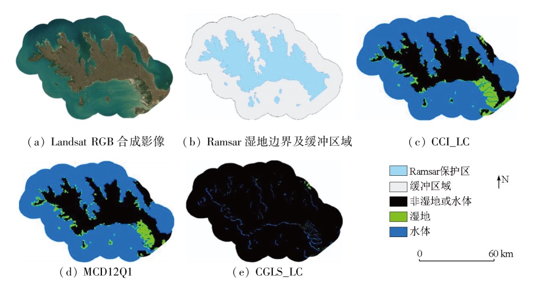
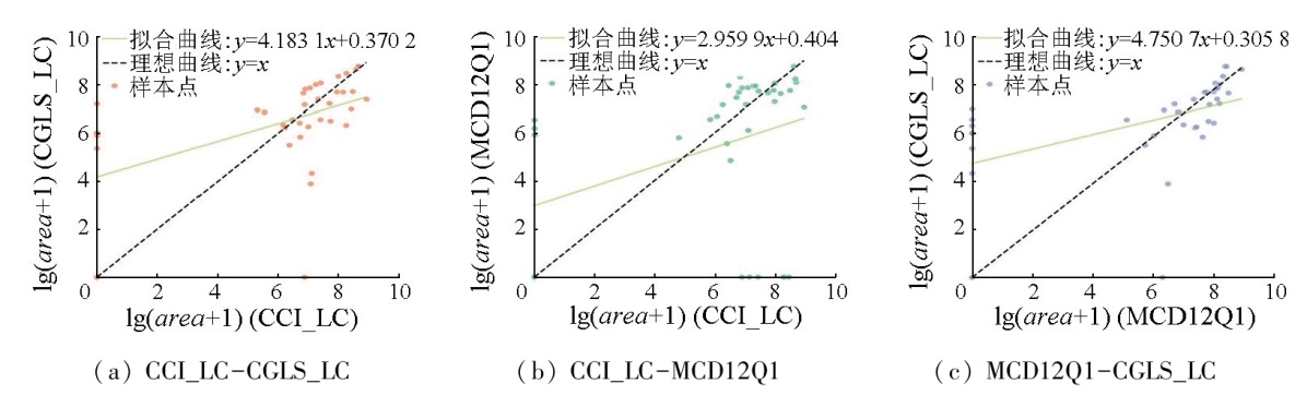
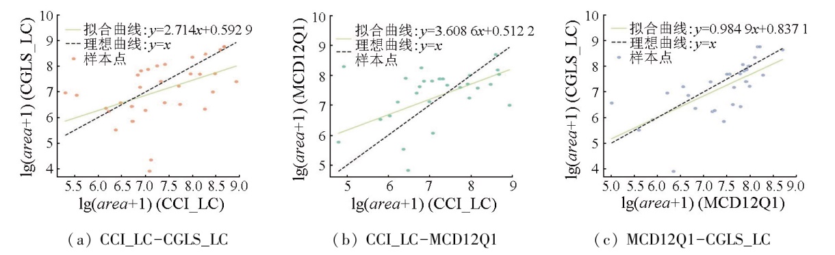
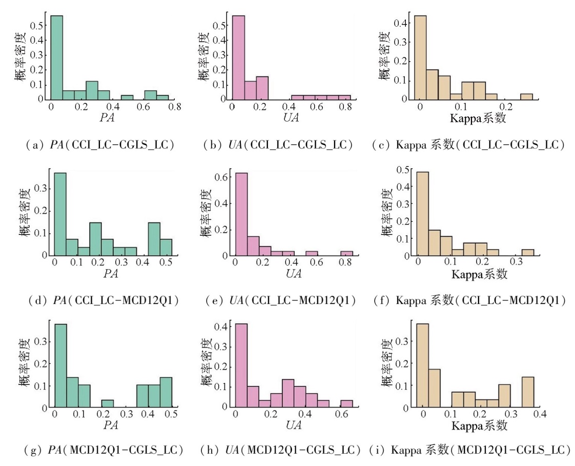
Abstract Monitoring wetland changes based on land cover mapping serves as a significant means for supervising contracting parties to the Convention on Wetlands of International Importance Especially as Waterfowl Habitat (also referred to as the Ramsar Convention) in fulfilling their obligations. However, substantial land cover mapping products available show significant differences in spatiotemporal characteristics, classification systems, and quality. This study conducted a consistency analysis of land cover mapping products for 40 wetlands of international importance in China from 2015 to 2019, aiming to provide a reference for selecting wetland mapping products and monitoring wetlands in Ramsar reserves. Using long time-series land cover mapping products CCI_LC, CGLS_LC, and MCD12Q1, this study preprocessed the data in terms of spatial and category consistency. Based on wetland classification areas, it conducted regression analysis and calculated the accuracy and uncertainty indicators of the mapping products. The results indicate that these products exhibited significant inconsistencies in wetland classification areas, with area differences averaging 6 to 10 times. Moreover, their wetland classification results were marked by low accuracy and high uncertainty. For most regions, the user accuracy (UA), producer accuracy (PA), and Kappa coefficient were below 0.1, and the standard deviation exceeded the mean. Overall, the three land cover mapping products fail to support credible monitoring of changes in wetlands of international importance.
|
| Keywords
Ramsar Convention
wetland remote sensing
consistency check of land cover products
|
|
|
|
Issue Date: 31 December 2025
|
|
|
| [1] |
Ramsar Convention Secretariat. The Ramsar Convention Manual:A guide to the Convention on Wetlands (Ramsar,Iran,1971),6th ed[R]. Gland, Switzerland: Ramsar Convention Secretariat, 2013.
|
| [2] |
Ramsar Convention Secretariat. The Fourth Ramsar Strategic Plan 2016—2024[R]// Ramsar Handbooks for the Wise Use of Wetlands,5th Edition,Vol.2.Gland, Switzerland: Ramsar Convention Secretariat, 2016.
|
| [3] |
Ramsar Convention Secretariat. Global Wetland Outlook:Special Edition 2021[R]. Gland, Switzerland: Ramsar Convention Secretariat, 2021.
|
| [4] |
Mao D H, Luo L, Wang Z M, et al. Conversions between natural wetlands and farmland in China:A multiscale geospatial analysis[J]. Science of The Total Environment, 2018,634:550-560.
|
| [5] |
Hu S J, Niu Z G, Chen Y F, et al. Global wetlands:Potential distribution,wetland loss,and status[J]. Science of The Total Environment, 2017,586:319-327.
|
| [6] |
Mao D H, Wang Z M, Wu J G, et al. China’s wetlands loss to urban expansion[J]. Land Degradation & Development, 2018, 29(8):2644-2657.
doi: 10.1002/ldr.v29.8
url: https://onlinelibrary.wiley.com/toc/1099145x/29/8
|
| [7] |
Rojas C, Munizaga J, Rojas O, et al. Urban development versus wetland loss in a coastal Latin American city:Lessons for sustainable land use planning[J]. Land Use Policy, 2019,80:47-56.
|
| [8] |
Mao D H, Yang H, Wang Z M, et al. Reverse the hidden loss of China’s wetlands[J]. Science, 2022, 376(6597):1061.
|
| [9] |
Mao D H, Tian Y L, Wang Z M, et al. Wetland changes in the Amur River Basin:Differing trends and proximate causes on the Chinese and Russian sides[J]. Journal of Environmental Management, 2021,280:111670.
|
| [10] |
Xi Y, Peng S S, Ciais P, et al. Future impacts of climate change on inland Ramsar wetlands[J]. Nature Climate Change, 2021, 11(1):45-51.
doi: 10.1038/s41558-020-00942-2
|
| [11] |
Davidson N C. How much wetland has the world lost? Long-term and recent trends in global wetland area[J]. Marine and Freshwater Research, 2014, 65(10):934-941.
doi: 10.1071/MF14173
url: https://connectsci.au/mf/article/65/10/934/59699/How-much-wetland-has-the-world-lost-Long-term-and
|
| [12] |
Cyranoski D. Putting China’s wetlands on the map[J]. Nature, 2009, 458(7235):134.
doi: 10.1038/458134a
|
| [13] |
Kingsford R T, Bino G, Finlayson C M, et al. Ramsar wetlands of international importance-improving conservation outcomes[J]. Frontiers in Environmental Science, 2021,9:643367.
|
| [14] |
Ramsar Convention Secretariat. Global Wetland Outlook:State of the World’s Wetlands and Their Services to People[R]. Gland, Switzerland: Ramsar Convention Secretariat, 2018.
|
| [15] |
Bridgewater P, Kim R E. The Ramsar convention on wetlands at 50[J]. Nature Ecology & Evolution, 2021, 5(3):268-270.
|
| [16] |
Davidson N C, Dinesen L, Fennessy S, et al. Trends in the ecological character of the world’s wetlands[J]. Marine and Freshwater Research, 2019, 71(1):127-138.
doi: 10.1071/MF18329
url: https://connectsci.au/mf/article/71/1/127/60466/Trends-in-the-ecological-character-of-the-world-s
|
| [17] |
Davidson N C, Dinesen L, Fennessy S, et al. A review of the adequacy of reporting to the Ramsar Convention on change in the ecological character of wetlands[J]. Marine and Freshwater Research, 2019, 71(1):117-126.
doi: 10.1071/MF18328
url: https://connectsci.au/mf/article/71/1/117/60465/A-review-of-the-adequacy-of-reporting-to-the
|
| [18] |
Valuing wetlands[J/OL]. Nature Geoscience, 2021, 14(3):111-111.doi:10.1038/s41561-021-00713-4.
|
| [19] |
Friedl M A, Sulla-Menashe D, Tan B, et al. MODIS Collection 5 global land cover:Algorithm refinements and characterization of new datasets[J]. Remote Sensing of Environment, 2010, 114(1):168-182.
doi: 10.1016/j.rse.2009.08.016
url: https://linkinghub.elsevier.com/retrieve/pii/S0034425709002673
|
| [20] |
Arino O, Ramoino F. Land Cover CCI Product User Guide Version 2.0[EB/OL]. 2017(2017-04-10) [2023-06-18].http://maps.elie.ucl.ac.be/CCI/viewer/download/ESACCI-LC-Ph2-PUGv2_2.0.pdf.
url: http://maps.elie.ucl.ac.be/CCI/viewer/download/ESACCI-LC-Ph2-PUGv2_2.0.pdf
|
| [21] |
Defourny P, Bicheron P, Brockmann C, et al. The first 300 m global land cover map for 2005 using ENVISAT MERIS time series:A product of the GlobCover system[M]. Ispra (Italy): Joint Research Centre of the European Commission, 2009.
|
| [22] |
Buchhorn M, Bertels L, Smets B, et al. Copernicus Global Land Service:Land Cover 100 m:Version 3 Globe 2015—2019:Algorithm Theoretical Basis Document[R/OL]. Zenodo, 2020(2020-09-08)[2022-08-23].https://zenodo.org/record/3938968.
url: https://zenodo.org/record/3938968
|
| [23] |
Gong P, Wang J, Yu L, et al. Finer resolution observation and monitoring of global land cover:First mapping results with Landsat TM and ETM+ data[J]. International Journal of Remote Sensing, 2013, 34(7):2607-2654.
doi: 10.1080/01431161.2012.748992
url: https://www.tandfonline.com/doi/full/10.1080/01431161.2012.748992
|
| [24] |
Zhang X, Liu L Y, Chen X D, et al. GLC_FCS30:Global land-cover product with fine classification system at 30 m using time-series Landsat imagery[J]. Earth System Science Data, 2021, 13(6):2753-2776.
doi: 10.5194/essd-13-2753-2021
|
| [25] |
Chen J, Chen J, Liao A P, et al. Global land cover mapping at 30 m resolution:A POK-based operational approach[J]. ISPRS Journal of Photogrammetry and Remote Sensing, 2015,103:7-27.
|
| [26] |
Liu H, Gong P, Wang J, et al. Production of global daily seamless data cubes and quantification of global land cover change from 1985 to 2020 - iMap World 1.0[J]. Remote Sensing of Environment, 2021,258:112364.
|
| [27] |
Gong P, Liu H, Zhang M N, et al. Stable classification with limited sample:Transferring a 30-m resolution sample set collected in 2015 to mapping 10-m resolution global land cover in 2017[J]. Science Bulletin, 2019, 64(6):370-373.
doi: 10.1016/j.scib.2019.03.002
url: https://linkinghub.elsevier.com/retrieve/pii/S2095927319301380
|
| [28] |
Zanaga D, Van De Kerchove S R, De Keersmaecker W, et al. ESA WorldCover 10 m 2020 v100[R/OL]. Zenodo, 2021(2021-10-20).https://zenodo.org/record/5571936.
url: https://zenodo.org/record/5571936
|
| [29] |
Brown C F, Brumby S P, Guzder-Williams B, et al. Dynamic World,Near real-time global 10 m land use land cover mapping[J]. Scientific Data, 2022,9:251.
|
| [30] |
Zhang X, Liu L Y, Zhao T T, et al. GWL_FCS30:A global 30 m wetland map with a fine classification system using multi-sourced and time-series remote sensing imagery in 2020[J]. Earth System Science Data Discussions, 2023, 15(1):265-293.
|
| [31] |
Murray N J, Phinn S R, DeWitt M, et al. The global distribution and trajectory of tidal flats[J]. Nature, 2019, 565(7738):222-225.
doi: 10.1038/s41586-018-0805-8
|
| [32] |
Bunting P, Rosenqvist A, Lucas R M, et al. The global mangrove watch:A new 2010 global baseline of mangrove extent[J]. Remote Sensing, 2018, 10(10):1669.
doi: 10.3390/rs10101669
url: https://www.mdpi.com/2072-4292/10/10/1669
|
| [33] |
Pekel J F, Cottam A, Gorelick N, et al. High-resolution mapping of global surface water and its long-term changes[J]. Nature, 2016, 540(7633):418-422.
doi: 10.1038/nature20584
|
| [34] |
Lehner B, Döll P. Development and validation of a global database of lakes,reservoirs and wetlands[J]. Journal of Hydrology, 2004, 296(1-4):1-22.
doi: 10.1016/j.jhydrol.2004.03.028
url: https://linkinghub.elsevier.com/retrieve/pii/S0022169404001404
|
| [35] |
McOwen C, Weatherdon L, Bochove J W, et al. A global map of saltmarshes[J]. Biodiversity Data Journal, 2017,5:e11764.
|
| [36] |
Hu S J, Niu Z G, Chen Y F. Global wetland datasets:A review[J]. Wetlands, 2017, 37(5):807-817.
doi: 10.1007/s13157-017-0927-z
url: https://link.springer.com/10.1007/s13157-017-0927-z
|
| [37] |
Murray N J, Worthington T A, Bunting P, et al. High-resolution mapping of losses and gains of Earth’s tidal wetlands[J]. Science, 2022, 376(6594):744-749.
doi: 10.1126/science.abm9583
url: https://www.science.org/doi/10.1126/science.abm9583
|
| [38] |
Mao D H, Wang Z M, Du B J, et al. National wetland mapping in China:A new product resulting from object-based and hierarchical classification of Landsat 8 OLI images[J]. ISPRS Journal of Photogrammetry and Remote Sensing, 2020,164:11-25.
|
| [39] |
Niu Z G, Gong P, Cheng X, et al. Geographical characteristics of China’s wetlands derived from remotely sensed data[J]. Science in China Series D:Earth Sciences, 2009, 52(6):723-738.
|
| [40] |
Peng K F, Jiang W G, Hou P, et al. Continental-scale wetland mapping:A novel algorithm for detailed wetland types classification based on time series Sentinel-1/2 images[J]. Ecological Indicators, 2023,148:110113.
|
| [41] |
Zhang Z, Xu N, Li Y F, et al. Sub-continental-scale mapping of tidal wetland composition for East Asia:A novel algorithm integrating satellite tide-level and phenological features[J]. Remote Sensing of Environment, 2022,269:112799.
|
| [42] |
Yang L M, Jin S M, Danielson P, et al. A new generation of the United States National Land Cover Database:Requirements,research priorities,design,and implementation strategies[J]. ISPRS Journal of Photogrammetry and Remote Sensing, 2018,146:108-123.
|
| [43] |
Gong P, Niu Z G, Cheng X, et al. China’s wetland change (1990—2000) determined by remote sensing[J]. Science China Earth Sciences, 2010, 53(7):1036-1042.
doi: 10.1007/s11430-010-4002-3
url: http://link.springer.com/10.1007/s11430-010-4002-3
|
| [44] |
张海英, 牛振国, 许盼盼. 大型国际重要湿地边界及遥感分类数据集(2001、2013)[J]. 全球变化数据学报, 2017, 1(2):230-238.
|
| [44] |
Zhang H Y, Niu Z G, Xu P P, et al. The boundaries and remote sensing classification datasets on large wetlands of international importance in 2001 and 2013[J]. Journal of Global Change Data & Discovery, 2017, 1(2):230-238.
|
| [45] |
Xing L W, Niu Z G, Xu P P, et al. Wetlands classification and assessment of Ramsar sites in China based on time series Moderate Resolution Imaging Spectroradiometer (MODIS) imagery[J]. Marine and Freshwater Research, 2018,69:658-668.
|
| [46] |
Mao D H, Wang Z M, Wang Y, et al. Remote observations in China’s Ramsar sites:Wetland dynamics,anthropogenic threats,and implications for sustainable development goals[J]. Journal of Remote Sensing, 2021,2021:9849343.
|
| [47] |
Gallant A. The challenges of remote monitoring of wetlands[J]. Remote Sensing, 2015, 7(8):10938-10950.
doi: 10.3390/rs70810938
url: https://www.mdpi.com/2072-4292/7/8/10938
|
| [48] |
Liu L Y, Zhang X, Gao Y, et al. Finer-resolution mapping of global land cover:Recent developments,consistency analysis,and prospects[J]. Journal of Remote Sensing, 2021,2021:5289697.
|
| [49] |
Gao Y, Liu L Y, Zhang X, et al. Consistency analysis and accuracy assessment of three global 30-m land-cover products over the European Union using the LUCAS dataset[J]. Remote Sensing, 2020, 12(21):3479.
doi: 10.3390/rs12213479
url: https://www.mdpi.com/2072-4292/12/21/3479
|
| [50] |
国家市场监督管理总局, 国家标准化管理委员会. GB/T 36296—2018 遥感产品真实性检验导则[S]. 北京: 中国标准出版社, 2018.
|
| [50] |
State Administration for Market Regulation, National standardization Administration. GB/T 36296—2018 Guide for the validation of remote sensing products[S]. Beijing: Standards Press of China, 2018.
|
| [51] |
国家市场监督管理总局, 国家标准化管理委员会. GB/T 41536—2022土地覆被遥感产品真实性检验[S]. 北京: 中国标准出版社, 2022.
|
| [51] |
State Administration for Market Regulation, National standardization Administration. GB/T 41536—2022 Validation of land cover remote sensing products[S]. Beijing: Standards Press of China, 2022.
|
|
Viewed |
|
|
|
Full text
|
|
|
|
|
Abstract
|
|
|
|
|
Cited |
|
|
|
|
| |
Shared |
|
|
|
|
| |
Discussed |
|
|
|
|
 2025,
Vol. 37
2025,
Vol. 37