|
|
|
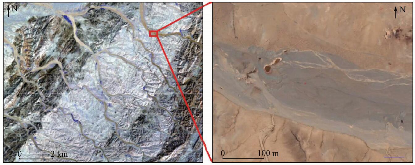
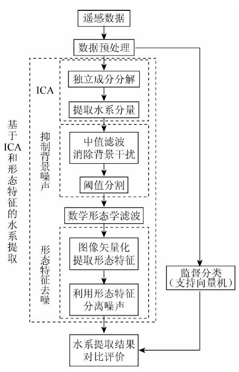
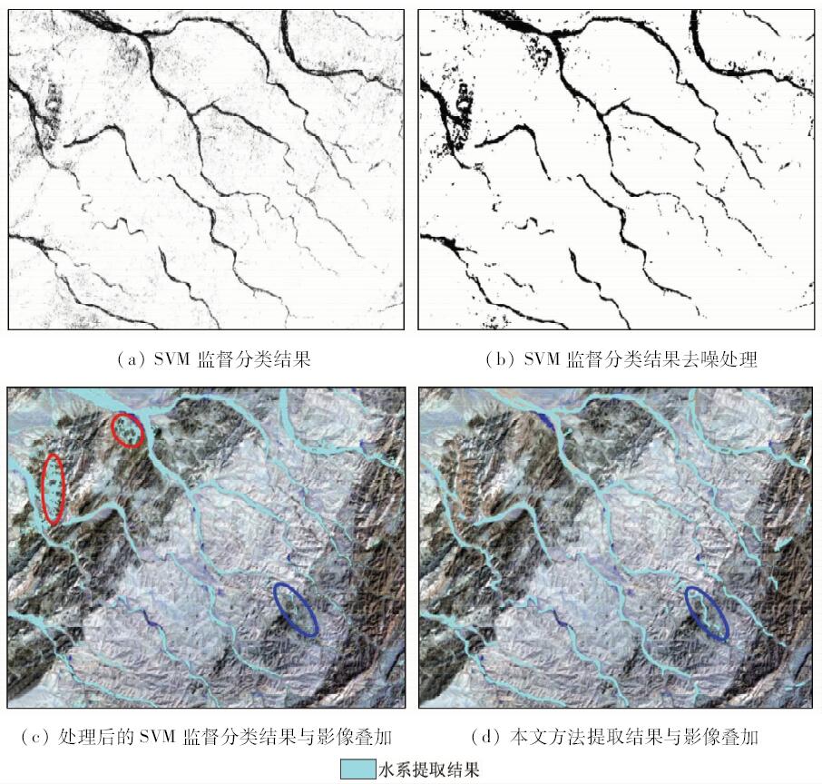
Abstract The extraction of drainage system is necessary in many geoscience research fields. For instance, drainage system is an important indicator for structure and lithologic interpretation, sample sites in stream sediment geochemical exploration are designed according to drainage system, and drainage system needs to be recognized and masked in mineral alteration extraction. The drainage system in remote sensing image is generally extracted according to spectral features of water body. However, in the dry drainage systems, such as gullies and seasonal rivers in dry season and under prolonged dry condition, the method based on water body is not applicable. To tackle this problem, the authors propose a method based on independent component analysis (ICA). ICA is a signal decomposition technique that converts multispectral data to independent components which represent independent signal sources, thereby enhancing and separating the specific target in the image. The streambed system extracted by ICA may be still accompanied by noisy data. A series of methods are used to enhance image and remove noise, which include background suppression, morphological filtering and de-noising based on morphological features. The proposed method was tested with ASTER data from Huogeqi area of Urad Rear Banner in Inner Mongolia Autonomous Region, and the result was compared with that derived from supervised classification. The results indicate that the method proposed in this paper can be used to identify dry drainage system, and the recognition result is better than the traditional supervised classification method. The method put forward by the authors performs better in interference information reduction and de-noising, and training data are not needed in this method. In conclusion, the method proposed in this paper is ideal and practical in the extraction of dry drainage system.
|
| Keywords
ICA
morphological features
streambed extraction
dry drainage system
background suppression
|
|
|
|
Corresponding Authors:
Runmin PENG
E-mail: cprm@cugb.edu.cn
|
|
Issue Date: 07 December 2018
|
|
|
| [1] |
王晓东 . 水系提取方法研究及其地质意义[D]. 吉林:吉林大学, 2015.
|
| [1] |
Wang X D . The Research of Drainage Extraction Method and Its Geological Significance[D]. Jilin:Jilin University, 2015.
|
| [2] |
都金康, 黄永胜, 冯学智 , 等. SPOT卫星影像的水体提取方法及分类研究[J]. 遥感学报, 2001,5(3):214-219.
doi: 10.3321/j.issn:1007-4619.2001.03.009
url: http://d.wanfangdata.com.cn/Periodical_ygxb200103009.aspx
|
| [2] |
Du J K, Huang Y S, Feng X Z , et al. Study on water bodies extraction and classification from SPOT image[J]. Journal of Remote Sensing, 2001,5(3):214-219.
|
| [3] |
杜云艳, 周成虎 . 水体的遥感信息自动提取方法[J]. 遥感学报, 1998,2(4):264-269.
doi: 10.11834/jrs.19980406
url: http://www.cqvip.com/qk/92457A/199804/3300536.html
|
| [3] |
Du Y Y, Zhou C H . Automatically extracting remote sensing information for water bodies[J]. Journal of Remote Sensing, 1998,2(4):264-269.
|
| [4] |
徐涵秋 . 利用改进的归一化差异水体指数(MNDWI)提取水体信息的研究[J]. 遥感学报, 2005,9(5):589-595.
doi: 10.3321/j.issn:1007-4619.2005.05.012
url: http://www.cqvip.com/Main/Detail.aspx?id=20226277
|
| [4] |
Xu H Q . A study on information extraction of water body with the modified normalized difference water index (MNDWI)[J]. Journal of Remote Sensing, 2005,9(5):589-595.
|
| [5] |
闫霈, 张友静, 张元 . 利用增强型水体指数(EWI)和GIS去噪音技术提取半干旱地区水系信息的研究[J]. 遥感信息, 2007,( 6):62-67.
|
| [5] |
Yan P, Zhang Y J, Zhang Y . A study on information extraction of water system in semi-arid regions with the enhanced water index(EWI) and GIS based noise remove techniques[J]. Remote Sensing Information, 2007,( 6):62-67.
|
| [6] |
Yousefi P, Jalab H A, Ibrahim R W , et al. River segmentation using satellite image contextual information and Bayesian classifier[J]. The Imaging Science Journal, 2016,64(8):453-459.
doi: 10.1080/13682199.2016.1236067
url: https://www.tandfonline.com/doi/full/10.1080/13682199.2016.1236067
|
| [7] |
Han B, Wu Y Q . A novel active contour model based on modified symmetric cross entropy for remote sensing river image segmentation[J]. Pattern Recognition, 2017,67:396-409.
doi: 10.1016/j.patcog.2017.02.022
url: https://linkinghub.elsevier.com/retrieve/pii/S0031320317300869
|
| [8] |
Bouaziz M, Wijaya A, Gloaguen R . Remote gully erosion mapping using ASTER data and geomorphologic analysis in the Main Ethiopian Rift[J]. Geo-spatial Information Science, 2011,14(4):246-254.
doi: 10.1007/s11806-011-0565-1
url: http://www.tandfonline.com/doi/abs/10.1007/s11806-011-0565-1
|
| [9] |
Taruvinga K . Gully Mapping Using Remote Sensing:Case Study in KwaZulu-Natal, South Africa[D]. Waterloo:University of Waterloo, 2009.
|
| [10] |
Castillo C, Taguas E V, Zarco-Tejada P , et al. The normalized topographic method:An automated procedure for gully mapping using GIS[J]. Earth Surface Processes and Landforms, 2015,39(15):2002-2015.
doi: 10.1002/esp.3595
url: http://onlinelibrary.wiley.com/doi/10.1002/esp.3595/pdf
|
| [11] |
Wang R H, Zhang S W, Pu L M , et al. Gully erosion mapping and monitoring at multiple scales based on multi-source remote sensing data of the Sancha River catchment,Northeast China[J]. ISPRS International Journal of Geo-Information, 2016,5(11):200.
doi: 10.3390/ijgi5110200
url: http://www.mdpi.com/2220-9964/5/11/200
|
| [12] |
Höfle B, Griesbaum L, Forbriger M . GIS-based detection of gullies in terrestrial LiDAR data of the Cerro Llamoca peatland (Peru)[J]. Remote Sensing, 2013,5(11):5851-5870.
doi: 10.3390/rs5115851
url: http://www.mdpi.com/2072-4292/5/11/5851
|
| [13] |
Karami A, Khoorani A, Nuhegar A , et al. Gully erosion mapping using object-based and pixel-based image classification methods[J]. Environmental and Engineering Geoscience, 2015,21(2):101-110.
doi: 10.2113/gseegeosci.21.2.101
url: https://pubs.geoscienceworld.org/eeg/article/21/2/101-110/60545
|
| [14] |
Tiwari K C, Arora M K, Singh D . An assessment of independent component analysis for detection of military targets from hyperspectral images[J]. International Journal of Applied Earth Observation and Geoinformation, 2011,13(5):730-740.
doi: 10.1016/j.jag.2011.03.007
url: https://linkinghub.elsevier.com/retrieve/pii/S030324341100050X
|
| [15] |
Zhang J P, Zhu F Y. Target detection approach for hyperspectral imagery based on independent component analysis and local singularity [C]//International Conference on Natural Computation.Tianjin:IEEE, 2009: 603-607.
|
| [16] |
金硕, 王斌, 夏威 . 基于带参考信号独立分量分析的高光谱图像目标探测[J]. 红外与毫米波学报, 2015,34(2):177-183.
url: http://www.opticsjournal.net/Articles/Abstract?aid=OJ150515000017C9FbHe
|
| [16] |
Jin S, Wang B, Xia W . Target detection in hyperspectral imagery based on independent component analysis with references[J]. Journal of Infrared and Millimeter Waves, 2015,34(2):177-183.
|
| [17] |
郑茂, 粘永健, 郑林华 . 基于独立分量分析的高光谱图像目标检测算法[J]. 信号处理, 2009,25(12):1912-1916.
doi: 10.3969/j.issn.1003-0530.2009.12.016
url: http://www.cqvip.com/Main/Detail.aspx?id=32313526
|
| [17] |
Zheng M, Nian Y J, Zheng L H . Target detection algorithm in hyperspectral imagery based on ICA[J]. Signal Processing, 2009,25(12):1912-1916.
|
| [18] |
戴青云, 余英林 . 数学形态学在图象处理中的应用进展[J]. 控制理论与应用, 2001,18(4):478-482.
doi: 10.3969/j.issn.1000-8152.2001.04.002
url: http://www.cqvip.com/qk/90555X/200104/5428133.html
|
| [18] |
Dai Q Y, Yu Y L . The advances of mathematical morphology in image processing[J]. Control Theory and Applications, 2001,18(4):478-482.
|
| [19] |
Sivanpillai R, Miller S N . Improvements in mapping water bodies using ASTER data[J]. Ecological Informatics, 2010,5(1):73-78.
doi: 10.1016/j.ecoinf.2009.09.013
url: http://linkinghub.elsevier.com/retrieve/pii/S1574954109000855
|
| [20] |
张茜凤, 上官冬辉, 刘时银 , 等. ASTER数据在寒区流域水系参数化中的应用——以木扎尔特流域为例[J]. 中国矿业大学学报, 2005,34(5):655-659.
doi: 10.3321/j.issn:1000-1964.2005.05.024
url: http://d.wanfangdata.com.cn/Periodical/zgkydxxb200505024
|
| [20] |
Zhang Q F, Shangguan D H, Liu S Y , et al. Application of ASTER data in parameterizing water system in cold region:Case study for Muzaerte valley[J]. Journal of China University of Mining and Technology, 2005,34(5):655-659.
|
| [21] |
Hyvärinen A, Oja E . Independent component analysis:Algorithms and applications[J]. Neural Networks, 2000,13(4-5):411-430.
doi: 10.1016/S0893-6080(00)00026-5
url: http://linkinghub.elsevier.com/retrieve/pii/S0893608000000265
|
| [22] |
Liu C J, Wechsler H. Comparative assessment of independent component analysis (ICA) for face recognition [C]//International Conference on Audio and Video Based Biometric Person Authentication.Washington D.C., 1999: 22-24.
|
| [23] |
Zhang K, Chan L W. ICA by PCA approach:Relating higher-order statistics to second-order moments [C]// International Conference on Independent Component Analysis and Signal Separation. Berlin:Springer, 2006: 311-318.
|
| [24] |
谢亮 . 基于独立分量分析特征提取方法的研究及其应用[D]. 金华:浙江师范大学, 2009.
|
| [24] |
Xie L . Reserch of Feature Extraction Based on Independent Component Analysis and Its Application[D]. Jinhua:Zhejiang Normal University, 2009.
|
| [25] |
杨竹青, 李勇, 胡德文 . 独立成分分析方法综述[J]. 自动化学报, 2002,28(5):762-772.
|
| [25] |
Yang Z Q, Li Y, Hu D W . Independent component analysis:A survey[J]. Acta Automatica Sinica, 2002,28(5):762-772.
|
| [26] |
金阿立, 王永仲 . 基于局部自适应中值滤波的红外背景抑制方法[J]. 红外技术, 2007,29(8):452-454.
|
| [26] |
Jin A L, Wang Y Z . Algorithm of suppressing infrared background baseing on local self-adaptive median filter[J]. Infrared Technology, 2007,29(8):452-454.
|
| [27] |
李辉, 代侦勇, 张利华 , 等. 利用数学形态学的遥感影像水系提取方法[J]. 武汉大学学报(信息科学版), 2011,36(8):956-959.
url: http://www.cqvip.com/QK/92848A/201108/38885515.html
|
| [27] |
Li H, Dai Z Y, Zhang L H , et al. Mathematical morphology based drainage line extraction from remote sensing image[J]. Geomatics and Information Science of Wuhan University, 2011,36(8):956-959.
|
| [28] |
Vapnik V N . The Nature of Statistical Learning Theory[M]. Springer Science and Business Media, 2013.
|
| [29] |
李琳, 张晓龙 . 基于RBF核的SVM学习算法的优化计算[J]. 计算机工程与应用, 2006,( 29):190-192,204.
|
| [29] |
Li L, Zhang X L . Optimization of SVM with RBF kernel[J].Computer Engineering and Applications, 2006(29):190-192,204.
|
|
Viewed |
|
|
|
Full text
|
|
|
|
|
Abstract
|
|
|
|
|
Cited |
|
|
|
|
| |
Shared |
|
|
|
|
| |
Discussed |
|
|
|
|
 2018,
Vol. 30
2018,
Vol. 30
 ), Yan YAN, Weiguang ZHAO