|
|
 |
|

|
|
|
Monitoring of Zanthoxylum bungeanum Maxim planting using GF-2 PMS images and the random forest algorithm: A case study of Linxia, Gansu Province |
LIU Mingxing1,2( ), LIU Jianhong1,2(), MA Minfei1,2, JIANG Ya1, ZENG Jingchao1,2 ), LIU Jianhong1,2(), MA Minfei1,2, JIANG Ya1, ZENG Jingchao1,2 |
1. College of Urban and Environmental Science, Northwest University, Xi’an 710127, China
2. Shaanxi Key Laboratory of Earth Surface System and Environmental Carrying Capacity, Northwest University, Xi’an 710127, China |
|
|
|
|
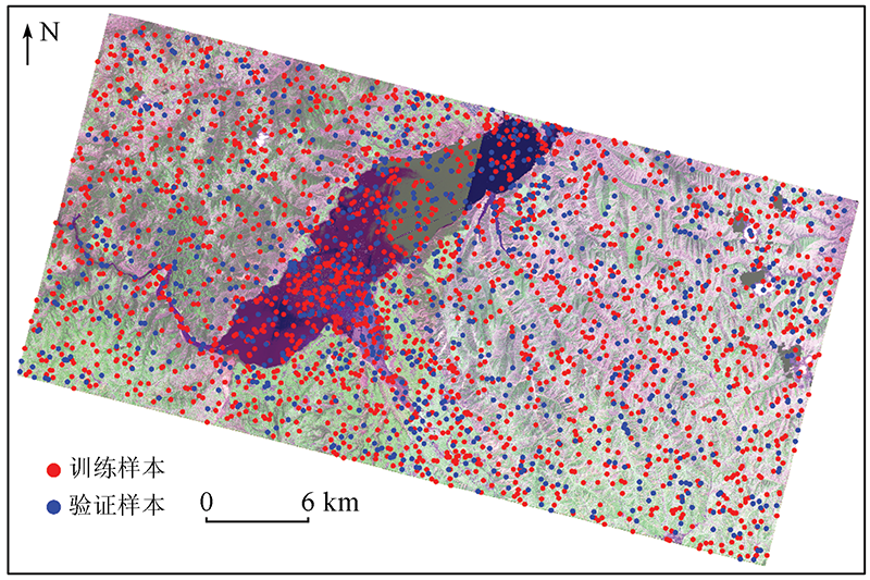
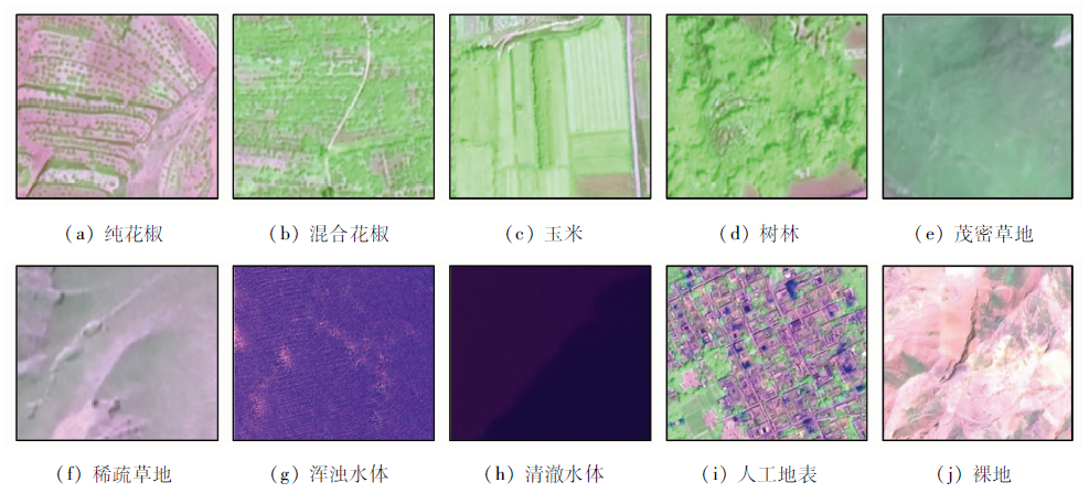
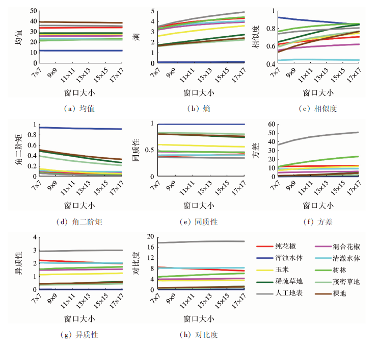
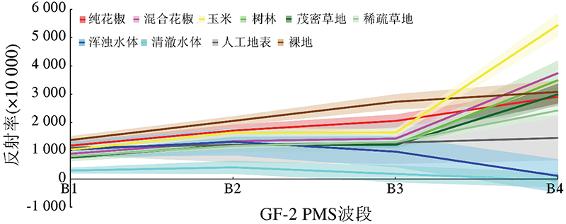
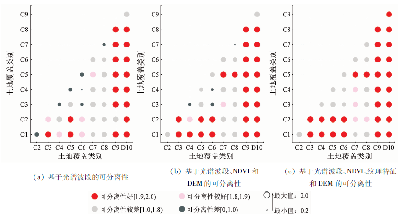
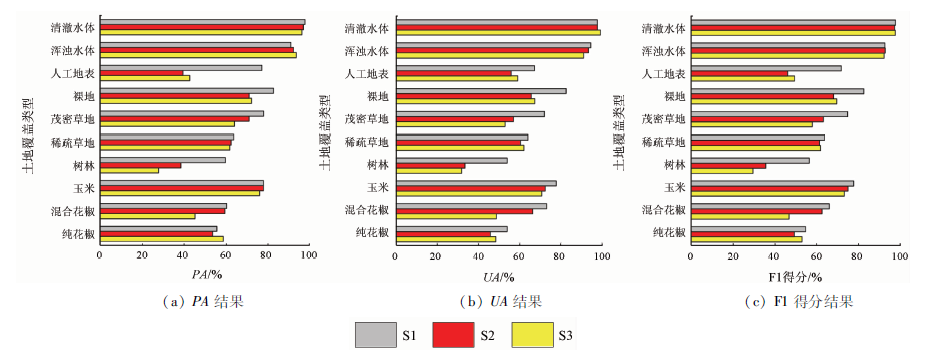
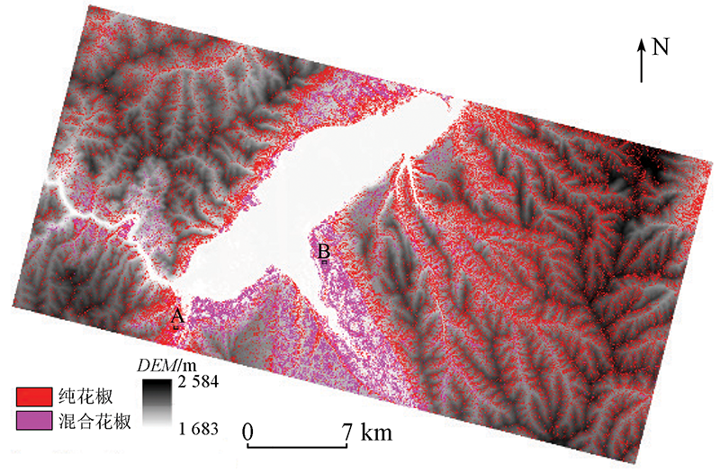
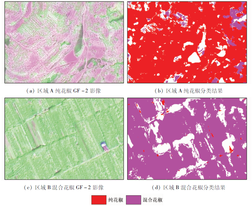
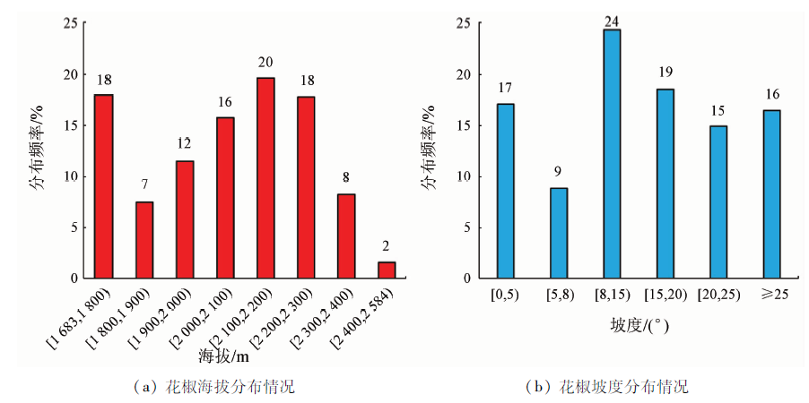
Abstract Major crops tend to receive far more attention in current remote sensing (RS) monitoring of vegetation than minor tree species with ecological and economic benefits. Zanthoxylum bungeanum Maxim (ZBM) is an important but niche ecological tree, and its fruits are common oil and medicinal materials. It is vital for the sustainable development of local economy, ecology, and society to obtain accurate information of planting area and spatial distribution ZBM in time. Using the GF-2 PMS images and the random forest algorithm, this study discussed the feasibility of RS monitoring of ZBM planting. Three classification schemes were designed using four classification features, namely spectral bands, normalized difference vegetation index (NDVI), textural features, and digital elevation model (DEM). Furthermore, this study explored the role of different classification features in identifying ZBM by analyzing the classification accuracy of the schemes. Results show that it is difficult to obtain satisfactory classification accuracy when only spectral band characteristics were used (overall accuracy: 65.90%). Combining NDVI and DEM with the spectral band characteristics can slightly improve the classification effect (overall accuracy: 67.67%). After textural features were further combined, the overall accuracy was greatly increased (74.43%). This indicates that textural features play an important role in monitoring ZBM planting. As revealed by the results of the optimal classification scheme, ZBM in Linxia, Gansu Province is mainly distributed along the Yellow River and around the Liujiaxia Reservoir, with a total area of 231.59 km2, which accounts for 22.56% of the total area of the study area. The area of ZBM planted in the patterns of single cropping and mixed cropping is 189.06 km2 and 42.53 km2, respectively. More than 90% of ZBM grows at an elevation of [1 683, 2 300) m and its number tends to decrease, increase, and decrease successively with an increase in the elevation. Moreover, 58% of ZBM are planted in regions with a slope of [8, 25)°. Overall, GF-2 PMS images have great potential in monitoring ZBM planting. The development of RS-based identification methods of ZBM will assist in the regulation of the local ecological industry and the layout of subsequent ecological engineering. Furthermore, it will provide a strong reference for the remote sensing monitoring of ecological tree species or a minority of vegetation species in other regions.
|
| Keywords
GF-2 PMS images
Zanthoxylum bungeanum Maxim
random forest
ecological engineering
planting monitoring
|
|
|
|
Corresponding Authors:
LIU Jianhong
E-mail: mingxingliu@stumail.nwu.edu.cn;jhliu@nwu.edu.cn
|
|
Issue Date: 14 March 2022
|
|
|
| [1] |
孔繁业. 临夏州林业可持续发展的思考[J]. 甘肃农业, 2006(2):104-105.
|
| [1] |
Kong F Y. Thinking on the sustainable development of forestry in Linxia Prefecture[J]. Gansu Agriculture, 2006(2):104-105.
|
| [2] |
刘萍. 临夏州花椒生产特点及产业发展建议[J]. 甘肃林业科技, 2003(4):80-83.
|
| [2] |
Liu P. Characteristics of Zanthoxylum bungeanum Maxim in Linxia Prefecture and suggestions for industrial development[J]. Journal of Gansu Forestry Science and Technology, 2003(4):80-83.
|
| [3] |
安树康. 临夏州花椒发展现状及对策[J]. 林业科技开发, 2004(4):76-78.
|
| [3] |
An S K. The development status and countermeasures of Zanthoxylum bungeanum in Linxia Prefecture[J]. Journal of Forestry Engineering, 2004(4):76-78.
|
| [4] |
Liu J, Li S, Ouyang Z, et al. Ecological and socioeconomic effects of China’s policies for ecosystem services[J]. Proceedings of the National Academy of Sciences, 2008, 105(28):9477-9482.
doi: 10.1073/pnas.0706436105
url: https://pnas.org/doi/full/10.1073/pnas.0706436105
|
| [5] |
Song X, Peng C, Zhou G, et al. Chinese grain for green program led to highly increased soil organic carbon levels:A meta-analysis[J]. Scientific Reports, 2014(4):4460.
|
| [6] |
杨学毅, 刘萍, 沈平, 等. 临夏州花椒有害生物种类及分布[J]. 甘肃林业科技, 2013, 38(4):25-30.
|
| [6] |
Yang X Y, Liu P, Shen P, et al. Species and distribution of pests of Zanthoxylum bungeanum in Linxia Prefecture[J]. Journal of Gansu forestry Science and Technology, 2013, 38(4):25-30.
|
| [7] |
Colomina I, Molina P. Unmanned aerial systems for photogrammetry and remote sensing:A review[J]. ISPRS Journal of Photogrammetry and Remote Sensing, 2014(92):79-97.
|
| [8] |
Ferreira M P, Alves D S, Shimabukuro Y E. Forest dynamics and land-use transitions in the Brazilian Atlantic Forest:The case of sugarcane expansion[J]. Regional Environmental Change, 2015, 15(2):365-377.
doi: 10.1007/s10113-014-0652-6
url: http://link.springer.com/10.1007/s10113-014-0652-6
|
| [9] |
Waldner F, Lambert M J, Li W, et al. Land cover and crop type classification along the season based on biophysical variables retrieved from multi-sensor high-resolution time series[J]. Remote Sensing, 2015, 7(8):10400-10424.
doi: 10.3390/rs70810400
url: http://www.mdpi.com/2072-4292/7/8/10400
|
| [10] |
Xu X, Conrad C, Doktor D. Optimising phenological metrics extraction for different crop types in Germany using the moderate resolution imaging spectrometer (MODIS)[J]. Remote Sensing, 2017, 9(3):254.
doi: 10.3390/rs9030254
url: http://www.mdpi.com/2072-4292/9/3/254
|
| [11] |
Hunt M L, Blackburn G A, Carrasco L, et al. High resolution wheat yield mapping using Sentinel-2[J]. Remote Sensing of Environment, 2019, 233:111410.
doi: 10.1016/j.rse.2019.111410
url: https://linkinghub.elsevier.com/retrieve/pii/S0034425719304298
|
| [12] |
Cheng Z, Meng J, Wang Y. Improving spring maize yield estimation at field scale by assimilating time-series HJ-1 CCD data into the WOFOST model using a new method with fast algorithms[J]. Remote Sensing, 2016, 8(4):303.
doi: 10.3390/rs8040303
url: http://www.mdpi.com/2072-4292/8/4/303
|
| [13] |
Mateo-Sanchis A, Piles M, Munoz-Mari J, et al. Synergistic integration of optical and microwave satellite data for crop yield estimation[J]. Remote Sensing of Environment, 2019, 234:111460.
doi: 10.1016/j.rse.2019.111460
pmid: 31798192
|
| [14] |
Sakamoto T. Incorporating environmental variables into a MODIS-based crop yield estimation method for United States corn and soybeans through the use of a random forest regression algorithm[J]. ISPRS Journal of Photogrammetry and Remote Sensing, 2020, 160:208-228.
doi: 10.1016/j.isprsjprs.2019.12.012
url: https://linkinghub.elsevier.com/retrieve/pii/S0924271619303065
|
| [15] |
Sakamoto T, Gitelson A A, Arkebauer T J. MODIS-based corn grain yield estimation model incorporating crop phenology information[J]. Remote Sensing of Environment, 2013, 131:215-231.
doi: 10.1016/j.rse.2012.12.017
url: https://linkinghub.elsevier.com/retrieve/pii/S003442571200483X
|
| [16] |
Tang X, Bullock E L, Olofsson P, et al. Near real-time monitoring of tropical forest disturbance:New algorithms and assessment framework[J]. Remote Sensing of Environment, 2019, 224:202-218.
doi: 10.1016/j.rse.2019.02.003
url: https://linkinghub.elsevier.com/retrieve/pii/S0034425719300598
|
| [17] |
Gómez C, White J C, Wulder M A. Characterizing the state and processes of change in a dynamic forest environment using hierarchical spatio-temporal segmentation[J]. Remote Sensing of Environment, 2011, 115(7):1665-1679.
doi: 10.1016/j.rse.2011.02.025
url: https://linkinghub.elsevier.com/retrieve/pii/S0034425711000757
|
| [18] |
Coppin P R, Bauer M E. Processing of multitemporal Landsat TM imagery to optimize extraction of forest cover change features[J]. IEEE Transactions on Geoscience and Remote Sensing, 1994, 32(4):918-927.
doi: 10.1109/36.298020
url: http://ieeexplore.ieee.org/document/298020/
|
| [19] |
Hornero A, Hernández-Clemente R, North P R J, et al. Monitoring the incidence of Xylella fastidiosa infection in olive orchards using ground-based evaluations,airborne imaging spectroscopy and Sentinel-2 time series through 3-D radiative transfer modelling[J]. Remote Sensing of Environment, 2020, 236:111480.
doi: 10.1016/j.rse.2019.111480
url: https://linkinghub.elsevier.com/retrieve/pii/S0034425719304997
|
| [20] |
Liu Z, Wang S. Detecting changes of wheat vegetative growth and their response to climate change over the North China Plain[J]. IEEE Journal of Selected Topics in Applied Earth Observations and Remote Sensing, 2018, 11(12):4630-4636.
doi: 10.1109/JSTARS.4609443
url: https://ieeexplore.ieee.org/xpl/RecentIssue.jsp?punumber=4609443
|
| [21] |
Oumar Z, Mutanga O. Integrating environmental variables and WorldView-2 image data to improve the prediction and mapping of Thaumastocoris peregrinus (bronze bug) damage in plantation forests[J]. ISPRS Journal of Photogrammetry and Remote Sensing, 2014, 87:39-46.
doi: 10.1016/j.isprsjprs.2013.10.010
url: https://linkinghub.elsevier.com/retrieve/pii/S0924271613002323
|
| [22] |
Zhong L, Hu L, Yu L, et al. Automated mapping of soybean and corn using phenology[J]. ISPRS Journal of Photogrammetry and Remote Sensing, 2016, 119:151-164.
doi: 10.1016/j.isprsjprs.2016.05.014
url: https://linkinghub.elsevier.com/retrieve/pii/S0924271616301071
|
| [23] |
Sakamoto T, Wardlow B D, Gitelson A A, et al. A two-step filtering approach for detecting maize and soybean phenology with time-series MODIS data[J]. Remote Sensing of Environment, 2010, 114(10):2146-2159.
doi: 10.1016/j.rse.2010.04.019
url: https://linkinghub.elsevier.com/retrieve/pii/S003442571000132X
|
| [24] |
Berger K, Verrelst J, Féret J-B, et al. Retrieval of aboveground crop nitrogen content with a hybrid machine learning method[J]. International Journal of Applied Earth Observation and Geoinformation, 2020, 92:102174.
doi: 10.1016/j.jag.2020.102174
url: https://linkinghub.elsevier.com/retrieve/pii/S0303243420303500
|
| [25] |
Xie Q, Dash J, Huete A, et al. Retrieval of crop biophysical parameters from Sentinel-2 remote sensing imagery[J]. International Journal of Applied Earth Observation and Geoinformation, 2019, 80:187-195.
doi: 10.1016/j.jag.2019.04.019
url: https://linkinghub.elsevier.com/retrieve/pii/S0303243419301199
|
| [26] |
Chauhan S, Srivastava H S, Patel P. Wheat crop biophysical parameters retrieval using hybrid-polarized RISAT-1 SAR data[J]. Remote Sensing of Environment, 2018, 216:28-43.
doi: 10.1016/j.rse.2018.06.014
url: https://linkinghub.elsevier.com/retrieve/pii/S0034425718302864
|
| [27] |
Gopal S, Woodcock C. Remote sensing of forest change using artificial neural networks[J]. IEEE Transactions on Geoscience and Remote Sensing, 1996, 34(2):398-404.
doi: 10.1109/36.485117
url: http://ieeexplore.ieee.org/document/485117/
|
| [28] |
Blackard J A, Dean D J. Comparative accuracies of artificial neural networks and discriminant analysis in predicting forest cover types from cartographic variables[J]. Computers and Electronics in Agriculture, 1999, 24(3):131-151.
doi: 10.1016/S0168-1699(99)00046-0
url: https://linkinghub.elsevier.com/retrieve/pii/S0168169999000460
|
| [29] |
Ingram J C, Dawson T P, Whittaker R J. Mapping tropical forest structure in southeastern Madagascar using remote sensing and artificial neural networks[J]. Remote Sensing of Environment, 2005, 94(4):491-507.
doi: 10.1016/j.rse.2004.12.001
url: https://linkinghub.elsevier.com/retrieve/pii/S003442570400361X
|
| [30] |
Peng C, Wen X. Recent applications of artificial neural networks in forest resource management:An overview[R]// Corté U,Sànche-Marrè M.Environmental Decision Support Systems and Artificial Intelligence.AAAI technical reports WS-99-07, 1999.
|
| [31] |
Huang C, Song K, Kim S, et al. Use of a dark object concept and support vector machines to automate forest cover change analysis[J]. Remote Sensing of Environment, 2008, 112(3):970-985.
doi: 10.1016/j.rse.2007.07.023
url: https://linkinghub.elsevier.com/retrieve/pii/S0034425707003951
|
| [32] |
Omer G, Mutanga O, Abdel-Rahman E M,et al.Performance of support vector machines and artificial neural network for mapping endangered tree species using WorldView-2 data in Dukuduku forest,South Africa[J]. IEEE Journal of Selected Topics in Applied Earth Observations and Remote Sensing, 2015, 8(10):4825-4840.
doi: 10.1109/JSTARS.4609443
url: https://ieeexplore.ieee.org/xpl/RecentIssue.jsp?punumber=4609443
|
| [33] |
Raczko E, Zagajewski B. Comparison of support vector machine,random forest and neural network classifiers for tree species classification on airborne hyperspectral APEX images[J]. European Journal of Remote Sensing, 2017, 50(1):144-154.
doi: 10.1080/22797254.2017.1299557
url: https://www.tandfonline.com/doi/full/10.1080/22797254.2017.1299557
|
| [34] |
Sesnie S E, Finegan B, Gessler P E, et al. The multispectral separability of Costa Rican rainforest types with support vector machines and random forest decision trees[J]. International Journal of Remote Sensing, 2010, 31(11):2885-2909.
doi: 10.1080/01431160903140803
url: https://www.tandfonline.com/doi/full/10.1080/01431160903140803
|
| [35] |
Mellor A, Haywood A, Stone C, et al. The performance of random forests in an operational setting for large area sclerophyll forest classification[J]. Remote Sensing, 2013, 5(6):2838-2856.
doi: 10.3390/rs5062838
url: http://www.mdpi.com/2072-4292/5/6/2838
|
| [36] |
Wyniawskyj N S, Napiorkowska M, Petit D, et al. Forest monitoring in Guatemala using satellite imagery and deep learning[C]// 2019 IEEE International Geoscience and Remote Sensing Symposium.IEEE, 2019:6598-6601.
|
| [37] |
Sylvain J D, Drolet G, Brown N. Mapping dead forest cover using a deep convolutional neural network and digital aerial photography[J]. ISPRS Journal of Photogrammetry and Remote Sensing, 2019, 156:14-26.
doi: 10.1016/j.isprsjprs.2019.07.010
url: https://linkinghub.elsevier.com/retrieve/pii/S0924271619301777
|
| [38] |
薛传平, 高志海, 孙斌, 等. 浑善达克沙地榆树疏林的高分辨率遥感识别方法[J]. 自然资源遥感, 2018, 30(4):74-81.doi: 10.6046/gtzyyg.2018.04.12.
doi: 10.6046/gtzyyg.2018.04.12
|
| [38] |
Xue C P, Gao Z H, Sun B, et al. Research on high resolution remote sensing recognition method of elm sparse forest in Otindag sandy land[J]. Remote Sensing for Land and Resources, 2018, 30(4):74-81.doi: 10.6046/gtzyyg.2018.04.12.
doi: 10.6046/gtzyyg.2018.04.12
|
| [39] |
杨欢, 邓帆, 张佳华, 等. 基于MODIS EVI的江汉平原油菜和冬小麦种植信息提取研究[J]. 自然资源遥感, 2020, 32(3):208-215.doi: 10.6046/gtzyyg.2020.03.27.
doi: 10.6046/gtzyyg.2020.03.27
|
| [39] |
Yang H, Deng F, Zhang J H, et al. A study of information extraction of rape and winter wheat planting in Jianghan Plain based on MODIS EVI[J]. Remote Sensing for Land and Resources, 2020, 32(3):208-215.doi: 10.6046/gtzyyg.2020.03.27.
doi: 10.6046/gtzyyg.2020.03.27
|
| [40] |
Wang M, Liu Z, Ali Baig M H, et al. Mapping sugarcane in complex landscapes by integrating multi-temporal Sentinel-2 images and machine learning algorithms[J]. Land Use Policy, 2019, 88:104190.
doi: 10.1016/j.landusepol.2019.104190
url: https://linkinghub.elsevier.com/retrieve/pii/S0264837719307185
|
| [41] |
You N, Dong J. Examining earliest identifiable timing of crops using all available Sentinel 1/2 imagery and Google Earth Engine[J]. ISPRS Journal of Photogrammetry and Remote Sensing, 2020, 161:109-123.
doi: 10.1016/j.isprsjprs.2020.01.001
url: https://linkinghub.elsevier.com/retrieve/pii/S0924271620300010
|
| [42] |
国贤玉, 李坤, 王志勇, 等. 基于SVM+SFS策略的多时相紧致极化SAR水稻精细分类[J]. 自然资源遥感, 2018, 30(4):20-27.doi: 10.6046/gtzyyg.2018.04.04.
doi: 10.6046/gtzyyg.2018.04.04
|
| [42] |
Guo X Y, Li K, Wang Z Y, et al. Fine classification of rice with multi-temporal compact polarimetric SAR based on SVM + SFS strategy[J]. Remote Sensing for Land and Resources, 2018, 30(4):20-27.doi: 10.6046/gtzyyg.2018.04.04.
doi: 10.6046/gtzyyg.2018.04.04
|
| [43] |
Liu M, Liu J, Atzberger C, et al. Zanthoxylum bungeanum Maxim mapping with multi-temporal Sentinel-2 images:The importance of different features and consistency of results[J]. ISPRS Journal of Photogrammetry and Remote Sensing, 2021, 174:68-86.
doi: 10.1016/j.isprsjprs.2021.02.003
url: https://linkinghub.elsevier.com/retrieve/pii/S0924271621000368
|
| [44] |
Waldner F, Chen Y, Lawes R, et al. Needle in a haystack:Mapping rare and infrequent crops using satellite imagery and data balancing methods[J]. Remote Sensing of Environment, 2019, 233:111375.
doi: 10.1016/j.rse.2019.111375
url: https://linkinghub.elsevier.com/retrieve/pii/S0034425719303943
|
| [45] |
Mayes S, Massawe F, Alderson P, et al. The potential for underutilized crops to improve security of food production[J]. Journal of Experimental Botany, 2012, 63(3):1075-1079.
doi: 10.1093/jxb/err396
pmid: 22131158
|
| [46] |
Tscharntke T, Clough Y, Wanger T C, et al. Global food security,biodiversity conservation and the future of agricultural intensification[J]. Biological Conservation, 2012, 151(1):53-59.
doi: 10.1016/j.biocon.2012.01.068
url: https://linkinghub.elsevier.com/retrieve/pii/S0006320712000821
|
| [47] |
Wu F, Fang X, Meng Q, et al. Magneto- and litho-stratigraphic records of the Oligocene-Early Miocene climatic changes from deep drilling in the Linxia Basin,Northeast Tibetan Plateau[J]. Global and Planetary Change, 2017, 158:36-46.
doi: 10.1016/j.gloplacha.2017.09.008
url: https://linkinghub.elsevier.com/retrieve/pii/S0921818117301388
|
| [48] |
肖国举, 王静. 黄土高原集水农业研究进展[J]. 生态学报, 2003(5):1003-1011.
|
| [48] |
Xiao G J, Wang J. Research on progress of rainwater harvesting agriculture on the Loess Plateau of China[J]. Acta Ecologica Sinica, 2003(5):1003-1011.
|
| [49] |
Chen Y, Zhang C, Wang S, et al. Extracting crop spatial distribution from Gaofen 2 imagery using a convolutional neural network[J]. Applied Sciences, 2019, 9(14):2917.
doi: 10.3390/app9142917
url: https://www.mdpi.com/2076-3417/9/14/2917
|
| [50] |
贾振华. 论临夏州花椒产业发展现状及对策[J]. 中国农业信息, 2014, 22:60-61.
|
| [50] |
Jia Z H. Discussion on the current situation and countermeasures of Zanthoxylum bungeanum industry[J]. China Agricultural Informatics, 2014, 22:60-61.
|
| [51] |
Tucker C J. Red and photographic infrared linear combinations for monitoring vegetation[J]. Remote Sensing of Environment, 1979, 8(2):127-150.
doi: 10.1016/0034-4257(79)90013-0
url: https://linkinghub.elsevier.com/retrieve/pii/0034425779900130
|
| [52] |
Carlson T N, Ripley D A. On the relation between NDVI,fractional vegetation cover,and leaf area index[J]. Remote Sensing of Environment, 1997, 62(3):241-252.
doi: 10.1016/S0034-4257(97)00104-1
url: https://linkinghub.elsevier.com/retrieve/pii/S0034425797001041
|
| [53] |
Zhu X, Liu D. Improving forest aboveground biomass estimation using seasonal Landsat NDVI time-series[J]. ISPRS Journal of Photogrammetry and Remote Sensing, 2015(102):222-231.
|
| [54] |
Yang F, Matsushita B, Fukushima T, et al. Temporal mixture analysis for estimating impervious surface area from multi-temporal MODIS NDVI data in Japan[J]. ISPRS Journal of Photogrammetry and Remote Sensing, 2012(72):90-98.
|
| [55] |
Haralick R M, Shanmugam K, Dinstein I H. Textural features for image classification[J]. IEEE Transactions on Systems,Man,and Cybernetics, 1973(6):610-621.
|
| [56] |
Wood E M, Pidgeon A M, Radeloff V C, et al. Image texture as a remotely sensed measure of vegetation structure[J]. Remote Sensing of Environment, 2012(121):516-526.
|
| [57] |
Breiman L. Random forests[J]. Machine Learning, 2001, 45(1):5-32.
doi: 10.1023/A:1010933404324
url: http://link.springer.com/10.1023/A:1010933404324
|
| [58] |
Hao P, Zhan Y, Wang L, et al. Feature selection of time series MODIS data for early crop classification using random forest:A case study in Kansas,USA[J]. Remote Sensing, 2015, 7(5):5347-5369.
doi: 10.3390/rs70505347
url: http://www.mdpi.com/2072-4292/7/5/5347
|
| [59] |
Rodriguez-Galiano V F, Ghimire B, Rogan J, et al. An assessment of the effectiveness of a random forest classifier for land-cover classification[J]. ISPRS Journal of Photogrammetry and Remote Sensing, 2012(67):93-104.
|
| [60] |
Foody G M. Status of land cover classification accuracy assessment[J]. Remote Sensing of Environment, 2002, 80(1):185-201.
doi: 10.1016/S0034-4257(01)00295-4
url: https://linkinghub.elsevier.com/retrieve/pii/S0034425701002954
|
| [61] |
Ifarraguerri A, Prairie M W. Visual method for spectral band selection[J]. IEEE Geoscience and Remote Sensing Letters, 2004, 1(2):101-106.
doi: 10.1109/LGRS.2003.822879
url: http://ieeexplore.ieee.org/document/1291391/
|
| [62] |
Li G, Sun S, Han J, et al. Impacts of Chinese grain for green program and climate change on vegetation in the Loess Plateau during 1982—2015[J]. Science of the Total Environment, 2019, 660:177-187.
doi: 10.1016/j.scitotenv.2019.01.028
url: https://linkinghub.elsevier.com/retrieve/pii/S0048969719300348
|
| [63] |
Li S, Yang S, Liu X, et al. NDVI-based analysis on the influence of climate change and human activities on vegetation restoration in the Shaanxi-Gansu-Ningxia Region,Central China[J]. Remote Sensing, 2015, 7(9):11163-11182.
doi: 10.3390/rs70911163
url: http://www.mdpi.com/2072-4292/7/9/11163
|
| [64] |
Li J, Peng S, Li Z. Detecting and attributing vegetation changes on China’s Loess Plateau[J]. Agricultural and Forest Meteorology, 2017, 247:260-270.
doi: 10.1016/j.agrformet.2017.08.005
url: https://linkinghub.elsevier.com/retrieve/pii/S0168192317302617
|
| [65] |
Anwer R M, Khan F S, van de Weijer J, et al. Binary patterns encoded convolutional neural networks for texture recognition and remote sensing scene classification[J]. ISPRS Journal of Photogrammetry and Remote Sensing, 2018, 138:74-85.
doi: 10.1016/j.isprsjprs.2018.01.023
url: https://linkinghub.elsevier.com/retrieve/pii/S0924271618300285
|
| [66] |
Ferreira M P, Wagner F H, Aragão L E O C, et al. Tree species classification in tropical forests using visible to shortwave infrared WorldView-3 images and texture analysis[J]. ISPRS Journal of Photogrammetry and Remote Sensing, 2019, 149:119-131.
doi: 10.1016/j.isprsjprs.2019.01.019
url: https://linkinghub.elsevier.com/retrieve/pii/S0924271619300280
|
| [67] |
Guo W, Rees W G. Altitudinal forest-tundra ecotone categorization using texture-based classification[J]. Remote Sensing of Environment, 2019, 232:111312.
doi: 10.1016/j.rse.2019.111312
url: https://linkinghub.elsevier.com/retrieve/pii/S0034425719303311
|
| [68] |
Drusch M, Del Bello U, Carlier S, et al. Sentinel-2:ESA’s optical high-resolution mission for GMES operational services[J]. Remote Sensing of Environment, 2012, 120:25-36.
doi: 10.1016/j.rse.2011.11.026
url: https://linkinghub.elsevier.com/retrieve/pii/S0034425712000636
|
| [69] |
Roy D P, Wulder M A, Loveland T R, et al. Landsat-8:Science and product vision for terrestrial global change research[J]. Remote Sensing of Environment, 2014, 145:154-172.
doi: 10.1016/j.rse.2014.02.001
url: https://linkinghub.elsevier.com/retrieve/pii/S003442571400042X
|
|
Viewed |
|
|
|
Full text
|
|
|
|
|
Abstract
|
|
|
|
|
Cited |
|
|
|
|
| |
Shared |
|
|
|
|
| |
Discussed |
|
|
|
|
 2022,
Vol. 34
2022,
Vol. 34