|
|
 |
|

|
|
|
Mangrove inter-species classification based on ZY-3 image in Leizhou Peninsula, Guangdong Province |
Yi ZHENG1,2, Yiqiong LIN1,2, Jian ZHOU1,2, Weixiu GAN1,2, Guangxuan LIN3, Fanghong XU3, Guanghui LIN1,2( ) ) |
1. Department of Earth System Science, Ministry of Education Key Laboratory for Earth System Modeling,Tsinghua University, Beijing 100084, China
2. Division of Ocean Science and Technology, Graduate School at Shenzhen, Tsinghua University, Shenzhen 518055, China
3. Bureau of Zhanjiang National Mangrove Nature Reserve, Zhanjiang 524000, China |
|
|
|
|
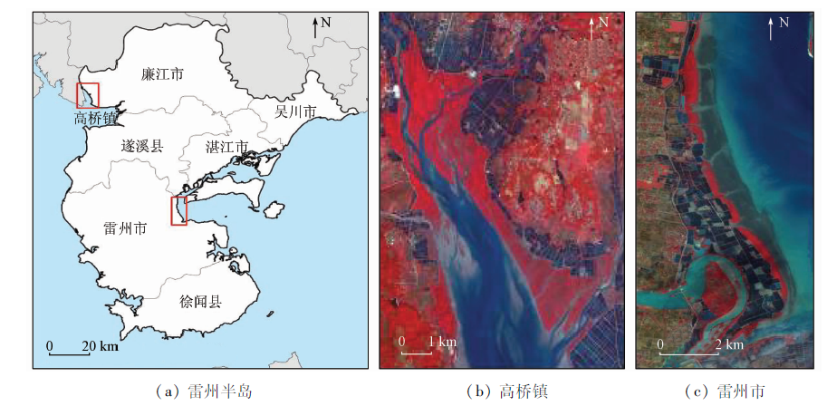
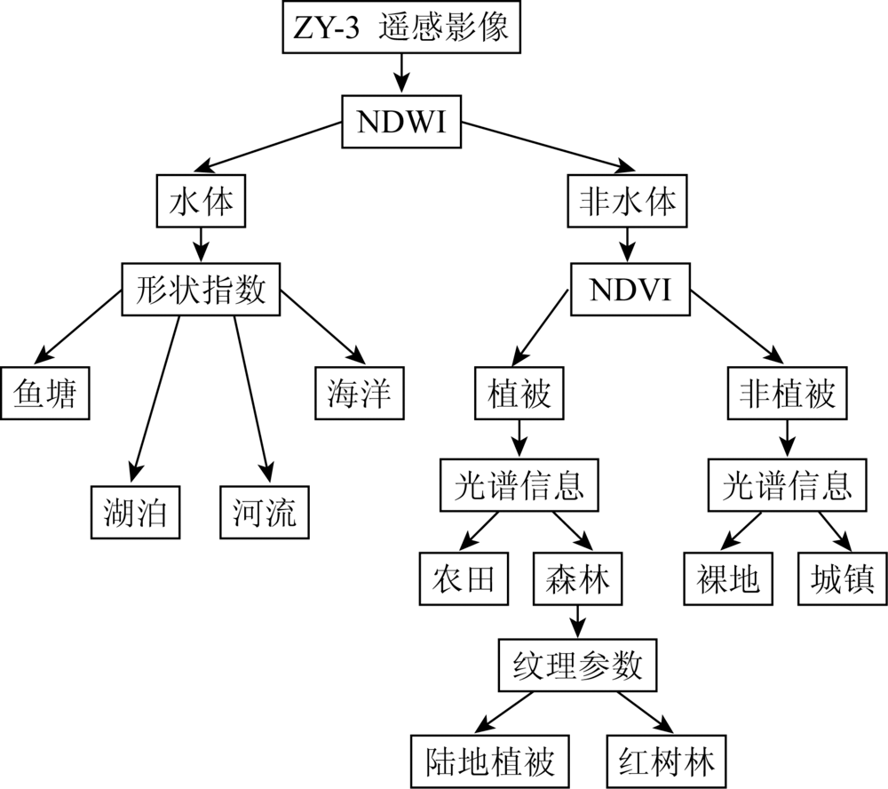
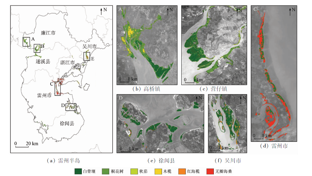
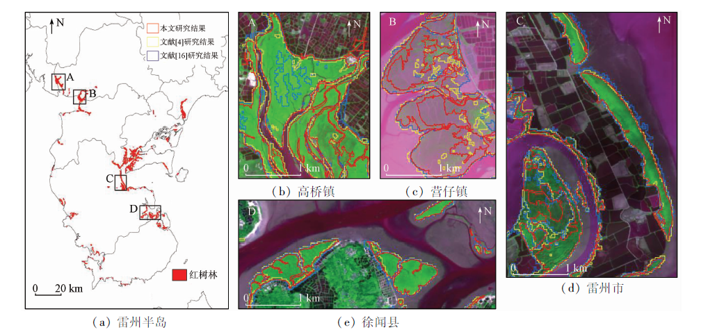
Abstract Mapping the distribution pattern of mangrove species in regional scales with remote sensing technology is of great significance in the investigation, utilization and protection of mangrove resources. In this study, the authors mapped and analyzed the mangrove species distribution based on the spectrum characteristics of mangroves,vegetation index, texture information and shape parameters calculated from ZY-3 high-resolution multispectral images, in conjunction with the mangrove species sample points, which were collected by the unmanned aerial vehicle (UAV). The authors used object-oriented classification method,decision tree and support vector machine (SVM). The total area of mangrove forests in Leizhou Peninsula in 2014 was estimated at 5 949.3 hm 2, much less than the area reported in most previous studies. For each of the districts in Leizhou Peninsula, mangrove forests covered 1 556.0 hm 2 in Lianjiang City, 1 466.1 hm 2 in Leizhou City, 1 168.0 hm 2 in Zhanjiang Municipal City, 734.7 hm 2 in Suixi County, 479.8 hm 2 in Xuwen County and 544.7 hm 2 in Wuchuan City, respectively. Zonal distribution of native mangrove species is significant from sea to land, with Avicennia marina dominated in the low tide level, followed by Aegiceras corniculatum, Kandelia obovata, Rhizophora stylosa and Brugueria gymnorrhiza dominated from middle to high tide level; the exotic mangrove species Sonneratia apetala is mainly distributed on the land side of Avicennia marina in its introduction area. The proportions of each dominate species are Avicennia marina (41.9%),Sonneratia apetala (23.4%), Aegiceras corniculatum (20.9%),Kandelia obovata(5.4%),Rhizophora stylosa(4.8%) and Brugueria gymnorrhiza (3.6%), respectively. The results show that Sonneratia apetala planting in Leizhou City and Zhanjiang Municipal City has achieved remarkable success in the past several years; however, the risk of its invasive and distribution expansion should also be taken into consideration.
|
| Keywords
mangroves
inter-species classification
high-resolwution imagery
object-oriented
|
|
|
|
Corresponding Authors:
Guanghui LIN
E-mail: lingh@tsinghua.edu.cn
|
|
Issue Date: 30 August 2019
|
|
|
| [1] |
Chen L Z, Wang W Q, Zhang Y H , et al. Recent progresses in mangrove conservation,restoration and research in China[J]. Journal of Plant Ecology, 2009,2(2):45-54.
|
| [2] |
贾明明 . 1973—2013年中国红树林动态变化遥感分析[D]. 北京:中国科学院大学, 2014.
|
| [2] |
Jia M M , Remote Sensing Analysis of China’s Mangrove Forests Dynamics During 1973 to 2013[D]. Beijing:University of Chinese Academy of Sciences, 2014.
|
| [3] |
但新球, 廖宝文, 吴照柏 , 等. 中国红树林湿地资源、保护现状和主要威胁[J]. 生态环境学报, 2016,25(7):1237-1243.
|
| [3] |
Dan X Q, Liao B W, Wu Z B , et al. Resources,conservation status and main threats of mangrove wetlands in China[J]. Ecology and Environmental Sciences, 2016,25(7):1237-1243.
|
| [4] |
Chen B Q, Xiao X M, Li X P , et al. A mangrove forest map of China in 2015:Analysis of time series Landsat 7/8 and Sentinel-1A imagery in Google Earth Engine cloud computing platform[J]. ISPRS Journal of Photogrammetry and Remote Sensing, 2017,131:104-120.
|
| [5] |
Kuenzer C, Bluemel A, Gebhardt S , et al. Remote sensing of mangrove ecosystems:A review[J]. Remote Sensing, 2011,3(5):878-928.
|
| [6] |
唐焕丽, 刘凯, 朱远辉 , 等. 基于WorldView-2数据和支持向量机的红树林群落分类研究[J]. 中山大学学报(自然科学版), 2015,54(4):102-111.
|
| [6] |
Tang H L, Liu K, Zhu Y H , et al. Mangrove community classification based on WorldView-2 image and SVM method[J]. Acta Scientiarum Naturalium Universitatis Sunyatseni, 2015,54(4):102-111.
|
| [7] |
肖海燕, 曾辉, 昝启杰 , 等. 基于高光谱数据和专家决策法提取红树林群落类型信息[J]. 遥感学报, 2007,11(4):531-537.
doi: 10.11834/jrs.20070473
|
| [7] |
Xiao H Y, Zeng H, Zan Q J , et al. Decision tree model in extraction of mangrove community information using hyperspectral image data[J]. Journal of Remote Sensing, 2007,11(4):531-537.
|
| [8] |
Wang T, Zhang H, Lin H , et al. Textural-spectral feature-based species classification of mangroves in Mai Po Nature Reserve from WorldView-3 imagery[J]. Remote Sensing, 2016,8(1):241-255.
|
| [9] |
Leempoel K, Satyaranayana B, Bourgeois C , et al. Dynamics in mangroves assessed by high-resolution and multi-temporal satellite data:A case study in Zhanjiang Mangrove National Nature Reserve (ZMNNR),P.R.China[J]. Biogeosciences, 2013,10(8):5681-5689.
|
| [10] |
苏岫, 赵冬至, 王祥 , 等. 基于SPOT5的红树林遥感分类[J]. 热带海洋学报, 2012,31(6):128-134.
doi: 10.3969/j.issn.1009-5470.2012.06.020
|
| [10] |
Su X, Zhao D Z, Wang X , et al. Remote sensing classification of mangrove based on SPOT5 image[J]. Journal of Tropical Oceanography, 2012,31(6):128-134.
|
| [11] |
廖宝文, 张乔民 . 中国红树林的分布、面积和树种组成[J], 湿地科学, 2014,12(4):435-440.
|
| [11] |
Liao B W, Zhang Q M . Area,distribution and species composition of mangroves in China[J]. Wetland Science, 2014,12(4):435-440.
|
| [12] |
赵玉灵 . 广东省海岸线与红树林现状遥感调查与保护建议[J]. 国土资源遥感, 2017,29(s1):114-120.doi: 10.6046/gtzyyg.2017.s1.19.
|
| [12] |
Zhao Y L . Remote sensing survey and proposal for protection of the shoreline and the mangrove wetland in Guangdong Province[J]. Remote Sensing for Land and Recourses, 2017,29(s1):114-120.doi: 10.6046/gtzyyg.2017.s1.19.
|
| [13] |
刘静, 马克明, 曲来叶 . 广东湛江红树林国家级自然保护区优势乔木群落的物种组成及结构特征[J]. 生态科学, 2016,35(3):1-7.
|
| [13] |
Liu J, Ma K M, Qu L Y . Species composition and community structure of dominant mangrove forests in Zhanjiang Mangrove National Nature Reserve,Guangdong Province[J]. Ecological Science, 2016,35(3):1-7.
|
| [14] |
吴培强, 马毅, 李晓敏 , 等. 广东省红树林资源变化遥感监测[J]. 海洋学研究, 2011,29(4):16-24.
|
| [14] |
Wu P Q, Ma Y, Li X M , et al. Remote sensing monitoring of the mangrove forests resources of Guangdong Province[J]. Journal of Marine Sciences, 2011,29(4):16-24.
|
| [15] |
韩维栋, 高秀梅, 卢昌义 , 等. 雷州半岛的红树林植物组成与群落生态[J]. 广西植物, 2003,23(2):127-132.
|
| [15] |
Han W D, Gao X M, Lu C Y , et al. Mangrove flora and associations of Leizhou Peninsula[J]. Guihaia, 2003,23(2):127-132.
|
| [16] |
吕婷婷, 周翔, 刘闯 , 等.东南亚地区红树林空间分布数据集(Mangrov_SEAsia_2015)[Z].全球变化科学研究数据出版系统, 2015.
|
| [16] |
Lyu T T, Zhou X, Liu C , et al. Data set of mangrove spatial distribution in Southeast Asia(Mangrov_SEAsia_2015)[Z].Global Change Research Date Publish and Repository, 2015.
|
| [17] |
吴培强 . 近20年来我国红树林资源变化遥感监测与分析[D]. 国家海洋局第一海洋研究所, 2012.
|
| [17] |
Wu P Q . Remote Sensing Monitoring and Analysis of the Changes of Mangrove Forests Resources in China in the Past 20 Years[D].The First Institute of Oceanography, SOA, 2012.
|
| [18] |
缪绅裕 . 广东湛江红树林保护区植物群落生态研究[J]. 广州师院学报(自然科学版), 2000,21(3):65-69.
|
| [18] |
Miao S Y . Ecological study on the mangrove forest in Zhanjiang Nature Reserve,Guangdong[J]. Journal of Guangzhou Normal University(Natural Science Edition), 2000,21(3):65-69.
|
| [19] |
梁士楚, 王伯荪 . 广西英罗港红树林区木榄群落土壤粒径分布的分形特征[J]. 热带海洋学报, 2003,22(1):17-22.
|
| [19] |
Liang S C, Wang B S . Fractal characteristics of soil particle-size distribution of Bruguiera gymnorrhiza community in mangrove area of Yingluo Bay,Guangxi Province[J], Journal of Tropical Oceanography, 2003,22(1):17-22.
|
|
Viewed |
|
|
|
Full text
|
|
|
|
|
Abstract
|
|
|
|
|
Cited |
|
|
|
|
| |
Shared |
|
|
|
|
| |
Discussed |
|
|
|
|
 2019,
Vol. 31
2019,
Vol. 31