|
|
 |
|

|
|
|
Object-oriented hierarchical identification of earthquake-induced landslides based on high-resolution remote sensing images |
LI Chenhui1( ), HAO Lina1,2(), XU Qiang2, WANG Yi1, YAN Lihua1 ), HAO Lina1,2(), XU Qiang2, WANG Yi1, YAN Lihua1 |
1. School of Earth Sciences, Chengdu University of Technology, Chengdu 610059, China
2. State Key Laboratory of Geohazard Prevention and Geoenvironment Protection, Chengdu 610059, China |
|
|
|
|
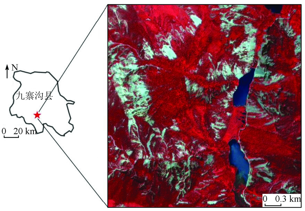
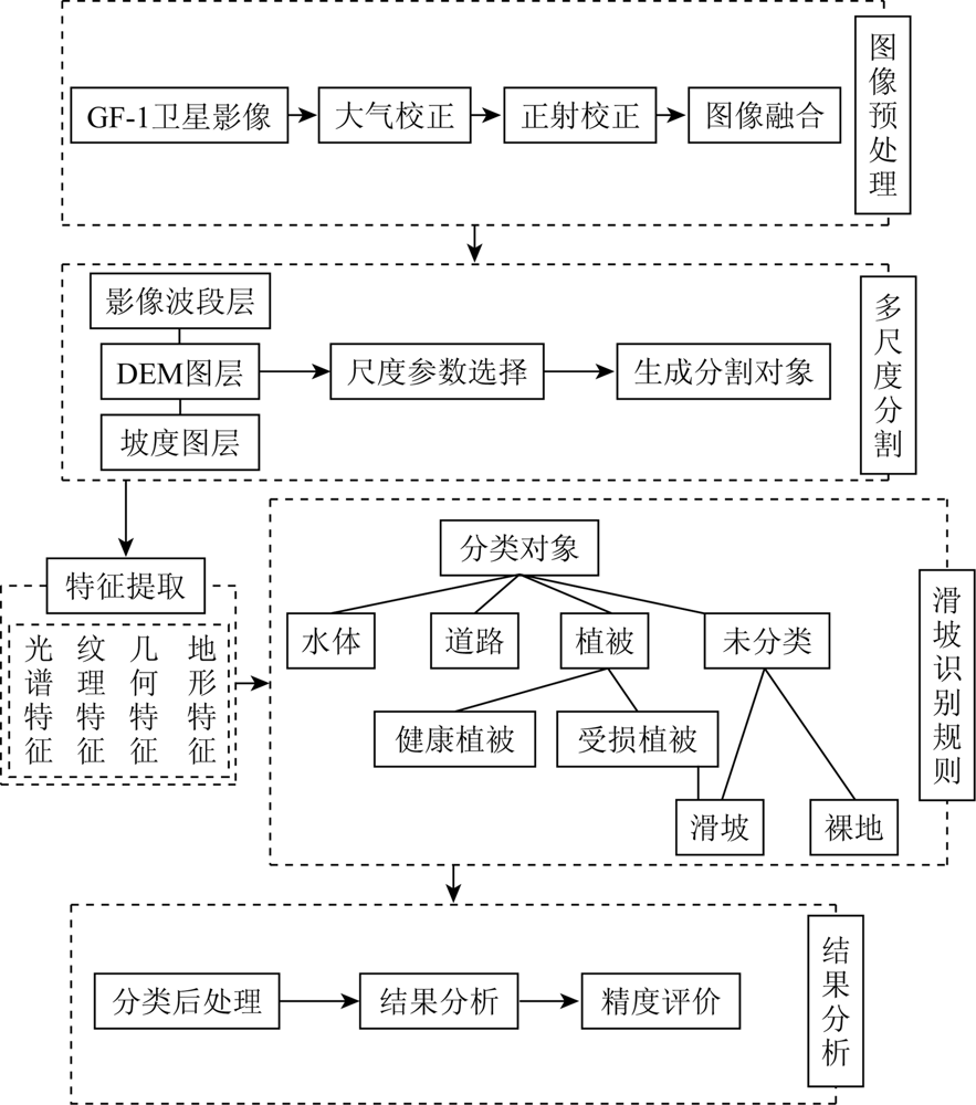
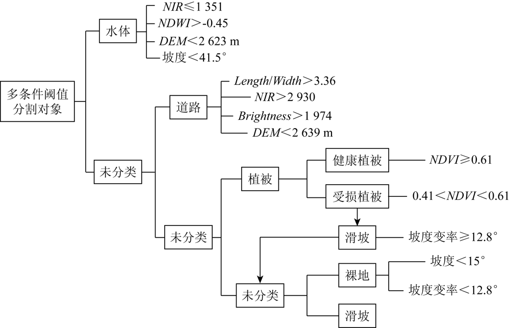
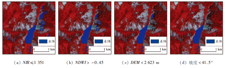
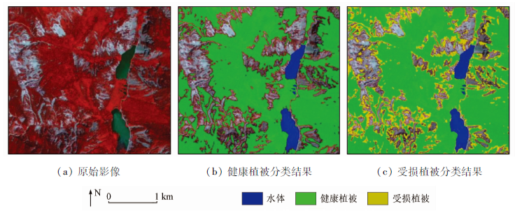
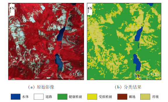
Abstract Earthquake-induced landslides are unnegligible secondary earthquake disasters and tend to cause severe casualties and property loss. Remote sensing identification of earthquake-induced landslides is an important means of the investigation and assessment of post-earthquake disasters. With GF-1 remote sensing images as a data source, this study identified the earthquake-induced landslides in the Xiongmaohai area in Jiuzhaigou using the object-oriented classification method. Specifically, the rule set for hierarchical identification of earthquake-induced landslides was constructed based on multi-scale segmentation and multi-conditional threshold classification. The aim is to fully utilize the features of ground objects, reduce the mixing of ground objects with similar spectra, and improve the identification precision of landslides. The identification results show that about 2.18 km2 of landslide area was extracted near the Xiongmaohai scenic spot, with a general identification accuracy of up to 98.11%. Therefore, the method proposed in this study can quickly identify earthquake-induced landslides, with high identification accuracy and applicable identification rules, and, thus, can be used as a reference and basis for the emergency investigation and rapid loss assessment of post-earthquake disasters.
|
| Keywords
earthquake-induced landslide
object-oriented
hierarchical identification of landslides
slope variability
|
|
|
|
Issue Date: 20 March 2023
|
|
|
| [1] |
许强, 黄润秋. 5·12汶川大地震诱发大型崩滑灾害动力特征初探[J]. 工程地质学报, 2008, 16(6):721-729.
|
| [1] |
Xu Q, Huang R Q. Kinetics charaterustics of large land-slides triggered by May 12th Wenchuan earthquake[J]. Journal of En-gineering Geology, 2008, 16(6):721-729.
|
| [2] |
裴向军, 黄润秋. “4·20”芦山地震地质灾害特征分析[J]. 成都理工大学学报(自然科学版), 2013, 40(3):257-263.
|
| [2] |
Pei X J, Huang R Q. Analysis of characteristics of geological hazards by “4·20” Lushan earthquake in Sichuan,China[J]. Journal of Chengdu University of Technology(Science & Technology Edition), 2013, 40(3):257-263.
|
| [3] |
崔鹏, 陈晓清, 张建强, 等. “4·20”芦山7.0级地震次生山地灾害活动特征与趋势[J]. 山地学报, 2013, 31(3):257-265.
|
| [3] |
Cui P, Chen X Q, Zhang J Q, et al. Activities and tendency of mountain hazards induced by the Ms 7.0 Lushan earthquake,April 20,2013[J]. Journal of Mountain Science, 2013, 31(3):257-265.
|
| [4] |
董秀军, 许强, 佘金星, 等. 九寨沟核心景区多源遥感数据地质灾害解译初探[J]. 武汉大学学报(信息科学版), 2020, 45(3):432-441.
|
| [4] |
Dong X J, Xu Q, She J X, et al. Preliminary study on interpretation of geological hazards in Jiuzhaigou based on multi-source remote sensing data[J]. Geomatics and Information Science of Wuhan University, 2020, 45(3):432-441.
|
| [5] |
许冲, 戴福初, 徐锡伟. 汶川地震滑坡灾害研究综述[J]. 地质论评, 2010, 56(6):860-874.
|
| [5] |
Xu C, Dai F C, Xu X W. Wenchuan earthquake-induced landslides:An overview[J]. Geological Review, 2010, 56(6):860-874.
|
| [6] |
黄润秋, 裴向军, 李天斌. 汶川地震触发大光包巨型滑坡基本特征及形成机理分析[J]. 工程地质学报, 2008, 16(6):730-741.
|
| [6] |
Huang R Q, Pei X J, Li T B. Basic characteristics and formation mechanism of the largest scale landslide scale landslide at Daguangbao occurred during the Wenchuan earthquake[J]. Journal of Engineering Geology, 2008, 16(6):730-741.
|
| [7] |
殷跃平. 汶川八级地震滑坡特征分析[J]. 工程地质学报, 2009, 17(1):29-38.
|
| [7] |
Yin Y P. Features of landslides triggered by the Wenchuan earthquake[J]. Journal of Engineering Geology, 2009, 17(1):29-38.
|
| [8] |
葛大庆. 地质灾害早期识别与监测预警中的综合遥感应用[J]. 城市与减灾, 2018, 123(6):53-60.
|
| [8] |
Ge D Q. Comprehensive application of remote sensing in early identification,monitoring and early warning in geological disasters[J]. City and Disaster Reduction, 2008, 123(6):53-60.
|
| [9] |
吴一全, 曹照清, 陶飞翔. 基于Contourlet变换和ICA的多时相遥感图像变化检测[J]. 地球物理学报, 2016, 59(4):1284-1292.
|
| [9] |
Wu Y Q, Cao Z Q, Tao F X. Change detection of multi-temporal remote sensing images based on contourlet transform and ICA[J]. Journal of Geophysics, 2016, 59(4):1284-1292.
|
| [10] |
郝立贞, 白世彪, 徐红波, 等. 基于CBERS-02卫星数据的地震滑坡识别——以青川县为例[J]. 防灾科技学院学报, 2010, 12(4):46-52.
|
| [10] |
Hao L Z, Bai S B, Xu H B, et al. Landslide identification after earthquake based on CBERS-02 remote sensing data:The case of Qingchuan[J]. Journal of Institute of Disaster Prevention, 2010, 12(4):46-52.
|
| [11] |
吴一全, 陶飞翔, 曹照清. 基于Shearlet变换和KPCA的多时相遥感图像变化检测[J]. 应用基础与工程科学学报, 2014, 22(5):1030-1040.
|
| [11] |
Wu Y Q, Tao F X, Cao Z Q. Change detection of multi-temporal remote sensing images based on Shearlet transform and KPCA[J]. Journal of Basic Science and Engineering, 2014, 22(5):1030-1040.
|
| [12] |
张群, 赵超英. 基于面向对象的高分遥感数据甘肃黑方台黄土滑坡半自动识别[J]. 灾害学, 2017, 32(3):210-215.
|
| [12] |
Zhang Q, Zhao C Y. Semiautomatic object-oriented loose landslide recognition based on high resolution remote sensing images in Heifangtai,Gansu[J] .Journal of Catastrophology, 2017, 32(3):210-215.
|
| [13] |
Martha T R, Babu G K, Vinod K K. Damage and geological assessment of the 18 September 2011 Mw 6.9 earthquake in Sikkim,India using very high resolution satellite data[J]. Geoscience Frontiers,2015, 6(6):793-805.
doi: 10.1016/j.gsf.2013.12.011
url: https://linkinghub.elsevier.com/retrieve/pii/S1674987114000279
|
| [14] |
Martha T R, Kamala P, Jose J, et al. Identification of new landslides from high resolution satellite data covering a large area using object-based change detection methods[J]. Research Article, 2016, 44(4):515-524.
|
| [15] |
Martha T R, Kerle N, Jetten V, et al. Characterising spectral spatial and morphometric properties of landslides for semiautomatic detection using object - oriented methods[J]. Geomorphology, 2010, 116(1):24-36.
doi: 10.1016/j.geomorph.2009.10.004
url: https://linkinghub.elsevier.com/retrieve/pii/S0169555X09004292
|
| [16] |
杨文涛, 汪明, 史培军, 等. 基于地形因子分割、分类的面向对象滑坡快速识别方法[J]. 自然灾害学报, 2015, 24(4):1-6.
|
| [16] |
Yang W T, Wang M, Shi P J, et al. Object-oriented rapid identification of landslides based on terrain factors segmentation and classification[J]. Journal of Natural Disasters, 2015, 24(4):1-6.
|
| [17] |
彭令, 徐素宁, 梅军军, 等. 资源三号卫星在汶川震区滑坡快速识别中的应用方法研究[J]. 遥感技术与应用, 2018, 33(1):185-192.
|
| [17] |
Peng L, Xu S N, Mei J J, et al. Research on Wenchuan earthquake-induced landslides rapid recognition from ZY-3 imagery[J]. Remote Sensing Technology and Application, 2018, 33(1):185-192.
|
| [18] |
彭令, 徐素宁, 梅军军, 等. 地震滑坡高分辨率遥感影像识别[J]. 遥感学报, 2017, 21(4):509-518.
|
| [18] |
Peng L, Xu S N, Mei J J, et al. Earthquake-induced landslide recognition using high-resolution remote sensing images[J]. Journal of Remote Sensing, 2017, 21(4):509-518.
|
| [19] |
杨柳, 牟鑫亮, 李晨, 等. 延安市宝塔区地质灾害风险评价[J]. 山地学报, 2020, 38(5):679-690.
|
| [19] |
Yang L, Mou X L, Li C, et al. Risk assessment of geological hazards in Baota District,Yan’an City,Shaanxi,China[J]. Journal of Mountain Science, 2020, 38(5):679-690.
|
| [20] |
吴润霖, 党星海, 周兆叶, 等. 岷县地质灾害易损性模糊综合评价[J]. 地理空间信息, 2021, 19(3):86-89.
|
| [20] |
Wu R L, Dang X H, Zhou Z Y, et al. Fuzzy comprehensive evaluation of the vulnerability of geological disasters in Min County[J]. Geospatial Information, 2021, 19(3):86-89.
|
| [21] |
戴岚欣, 许强, 范宣梅, 等. 2017年8月8日四川九寨沟地震诱发地质灾害空间分布规律及易发性评价初步研究[J]. 工程地质学报, 2017, 25(4):1151-1164.
|
| [21] |
Dai L X, Xu Q, Fan X M, et al. A preliminary study on spatial distribution patterns of landslides triggered by Jiuzhaigou earthquake in Sichuan on August 8th,2017 and their susceptibility assessment[J]. Journal of Engineering Geology, 2017, 25(4):1151-1164.
|
| [22] |
陈文倩, 丁建丽, 王娇, 等. 基于高分一号影像的土地覆被分类方法初探[J]. 干旱区地理, 2016, 39(1):182-189.
|
| [22] |
Chen W Q, Ding J L, Wang J, et al. Classification method of land cover based on GF-1 image[J]. Arid Land Geography, 2016, 39(1):182-189.
|
| [23] |
黄志坚. 面向对象影像分析中的多尺度方法研究[D]. 长沙: 国防科学技术大学, 2014:38-40.
|
| [23] |
Huang Z J. Research on multi-scale methods in object-based image analysis[D]. Changsha: National University of Defense Technology, 2014:38-40.
|
| [24] |
关元秀, 王学恭. eCognition基于对象影像分析教程[M]. 北京: 科学出版社, 2019:40-43.
|
| [24] |
Guan Y X, Wang X G. Object based image analysis tutorial[M]. Beijing: Science Press, 2019:40-43.
|
|
Viewed |
|
|
|
Full text
|
|
|
|
|
Abstract
|
|
|
|
|
Cited |
|
|
|
|
| |
Shared |
|
|
|
|
| |
Discussed |
|
|
|
|
 2023,
Vol. 35
2023,
Vol. 35