|
|
 |
|

|
|
|
Spatio-temporal variations in mangrove forests in the Shankou Mangrove Nature Reserve based on the GEE cloud platform and Landsat data |
SHI Min1,2( ), LI Huiying1(), JIA Mingming3 ), LI Huiying1(), JIA Mingming3 |
1. School of Environmental and Municipal Engineering, Qingdao University of Technology, Qingdao 266520, China
2. College of Geography, Nanjing Normal University, Nanjing 210023, China
3. Key Laboratory of Wetland Ecology and Environment, Northeast Institute of Geography and Agroecology, Chinese Academy of Sciences, Changchun 130102, China |
|
|
|
|
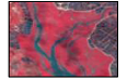
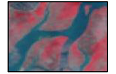
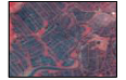
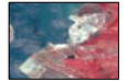
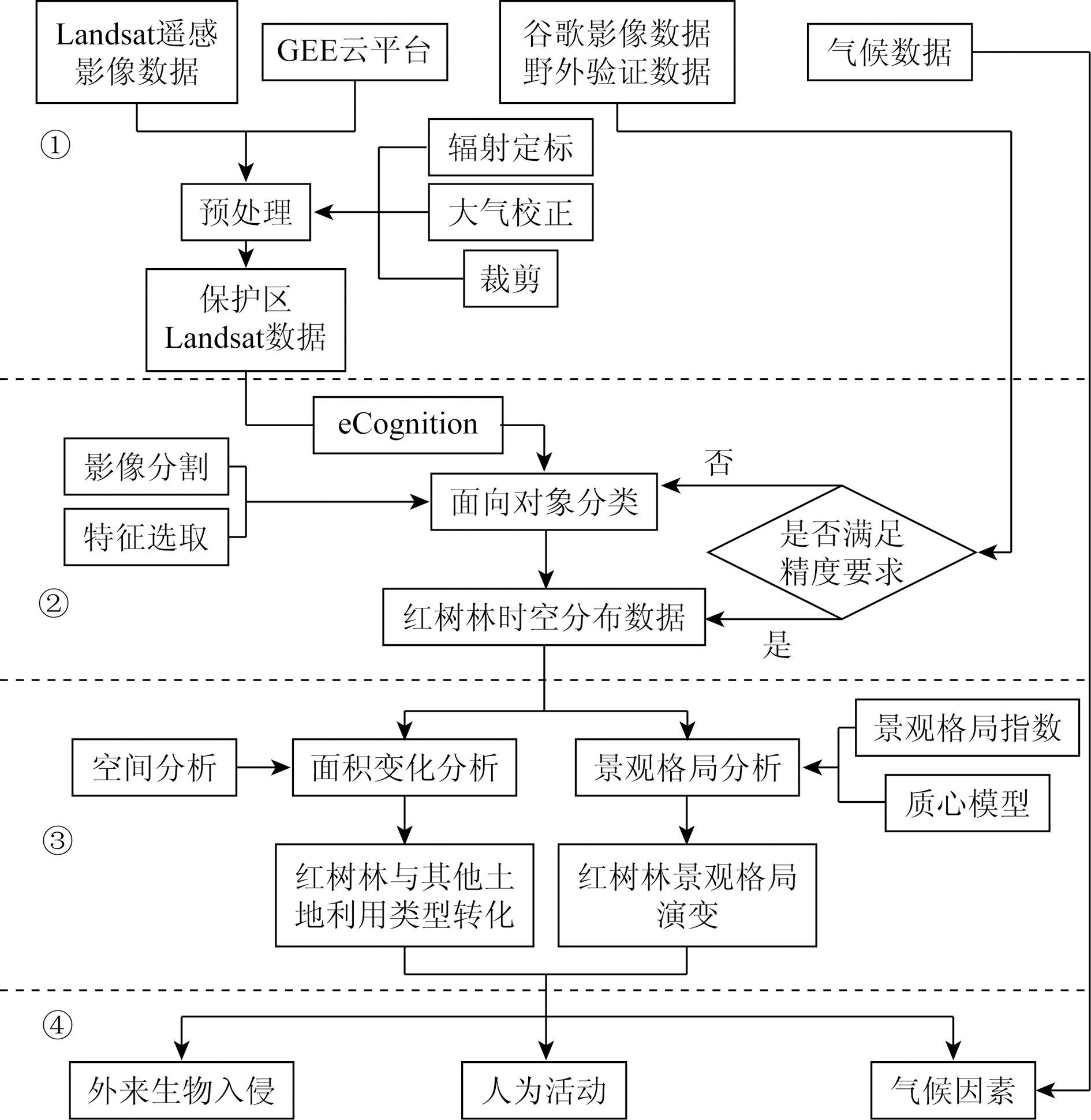
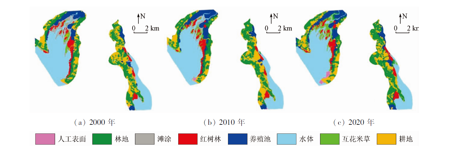
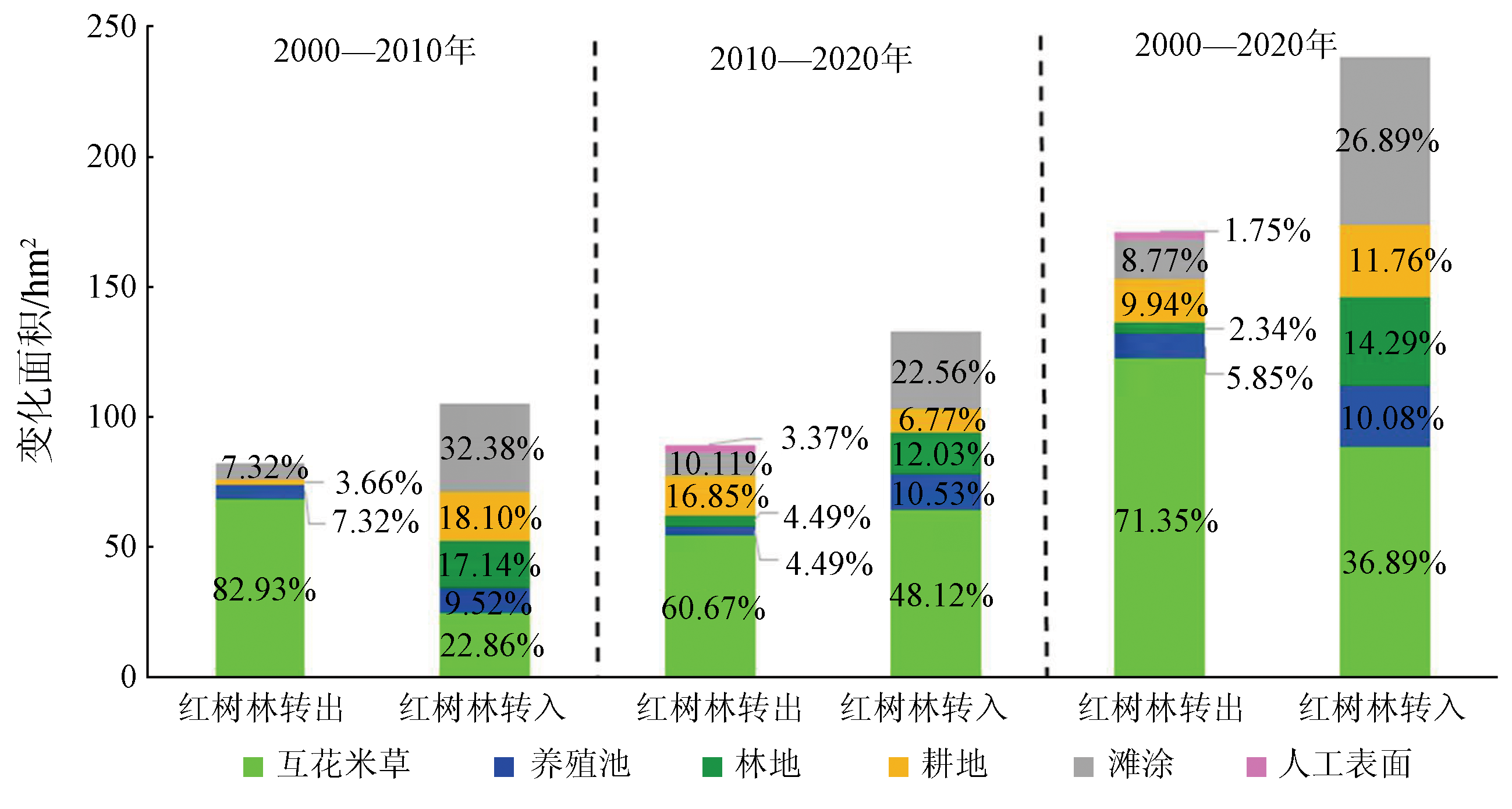
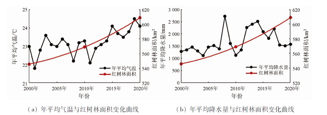
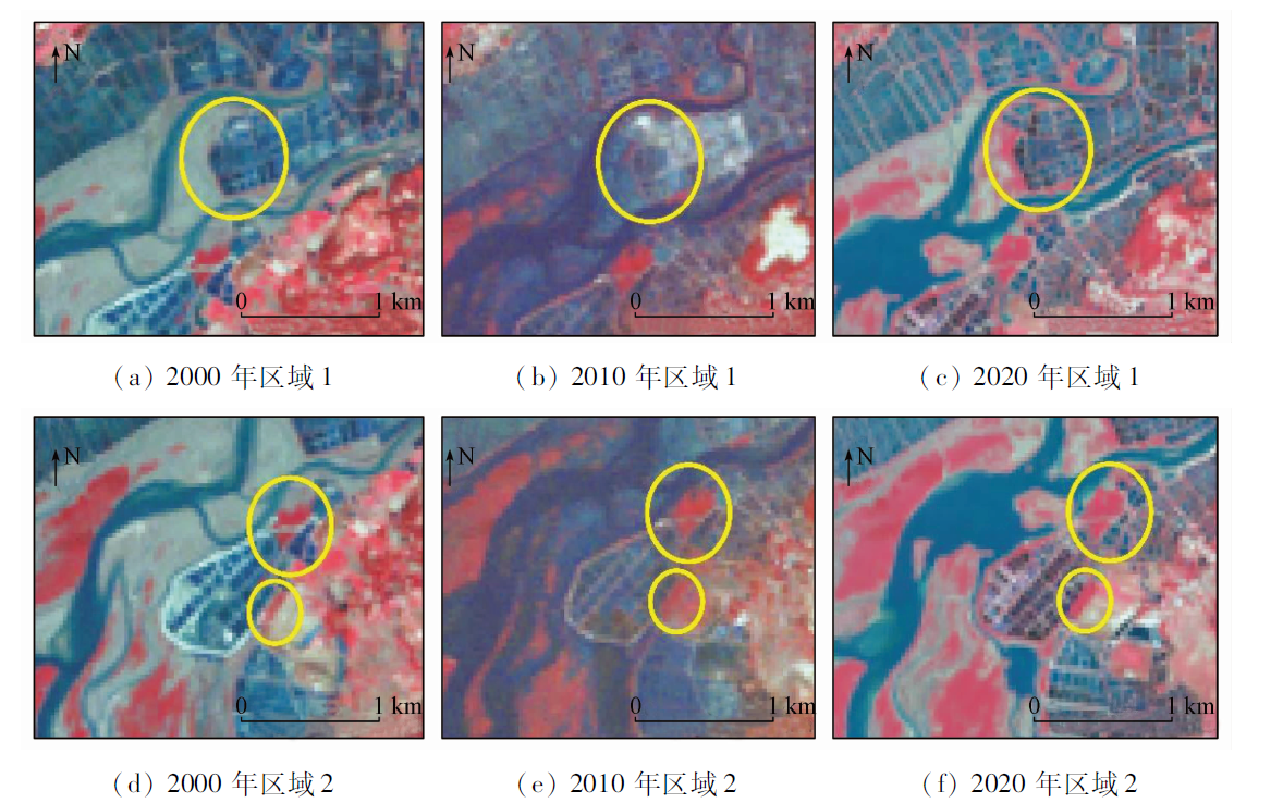
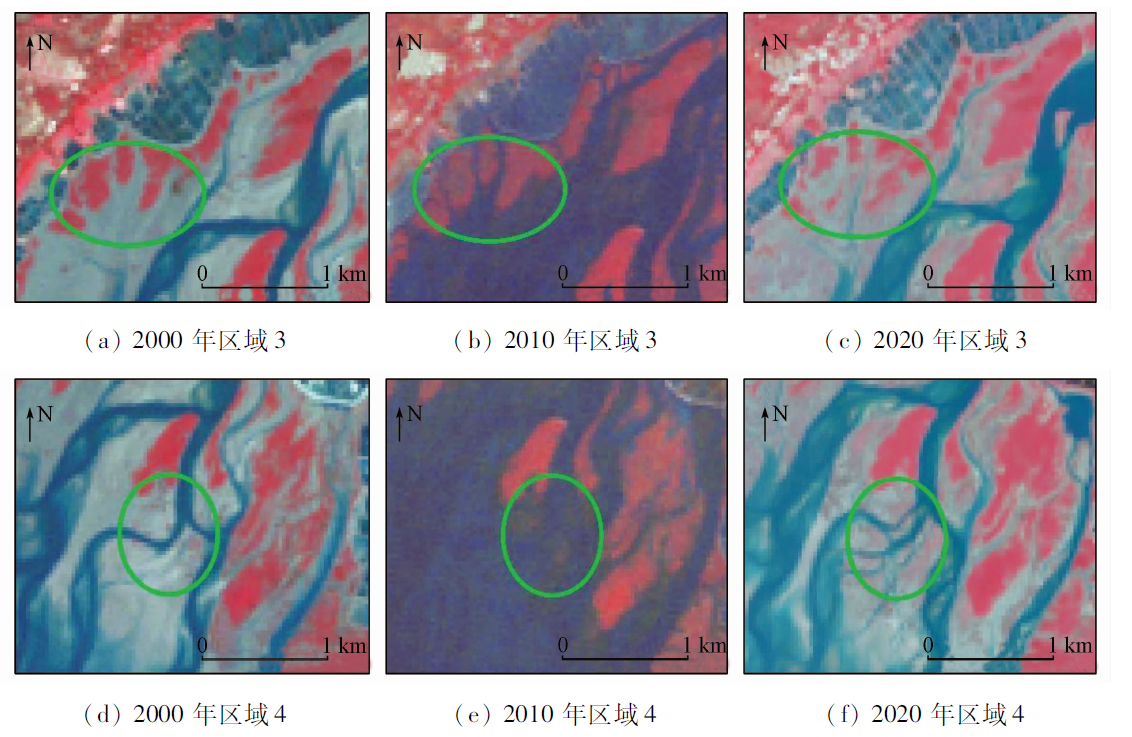
Abstract Conventional processing methods for remote sensing data are inefficient and time-consuming. Using the object-oriented classification method this study extracted the distribution of mangrove forests of 2000, 2010, and 2020 in the Shankou Mangrove Nature Reserve in Guangxi based on the GEE cloud platform and Landsat TM/OLI remote sensing data. Then, this study monitored the spatio-temporal variations in mangrove forests in the study area in combination with the landscape analysis method and revealed their driving factors. The results are as follows: ① During 2000—2020, the mangrove forests in the study area increased by about 63 hm2, including a significant increase of about 40 hm2 during 2010—2020; ② Compared with other land use types, the mangrove forests showed the most intense conversion with spartina alterniflora areas and mudflats, with 152 hm2 of spartina alterniflora areas and mudflats being converted to mangrove forests and 122 hm2 of mangrove forests being converted to spartina alterniflora areas over the 20 years; ③ During 2000—2020, the mangrove landscape in the study area showed decreased fragmentation, increased patch aggregation, continuously expanded landscape dominance, and landward migration of the mangrove forest centroid; ④ Among the factors affecting the area of mangrove forests in the nature reserve, the control of invasive vegetation and moderate aquaculture can increase the area of mangrove forests, while climate changes and invasive vegetation had adverse effects on the growth of mangrove forests. The results of this study will provide a method reference and data basis for the conservation and management of mangrove wetlands in Shankou, Guangxi.
|
| Keywords
mangrove forest
GEE
object-oriented classification
landscape analysis
|
|
|
|
Issue Date: 07 July 2023
|
|
|
| [1] |
贾明明. 1973—2013年中国红树林动态变化遥感分析[D]. 长春: 中国科学院研究生院东北地理与农业生态研究所, 2014.
|
| [1] |
Jia M M. Remote sensing analysis of China’s mangrove forests dynamics during 1973 to 2013[D]. Changchun: University of Chinese Academy of Sciences, 2014.
|
| [2] |
王浩, 任广波, 吴培强, 等. 1990—2019年中国红树林变迁遥感监测与景观格局变化分析[J]. 海洋技术学报, 2020, 39(5):1-12.
|
| [2] |
Wang H, Ren G B, Wu P Q, et al. Analysis on the remote sensing monitoring and landscape pattern change of mangrove in China from 1990 to 2019[J]. Journal of Ocean Technology, 2020, 39(5):1-12.
|
| [3] |
杨盛昌, 陆文勋, 邹祯, 等. 中国红树林湿地:分布、种类组成及其保护[J]. 亚热带植物科学, 2017, 46(4):301-310.
|
| [3] |
Yang S C, Lu W X, Zou Z, et al. Mangrove wetlands:Distribution,species composition and protection in China[J]. Subtropical Plant Science, 2017, 46(4):301-310.
|
| [4] |
贾明明, 王宗明, 毛德华, 等. 面向可持续发展目标的中国红树林近50年变化分析[J]. 科学通报, 2021, 66(30):3886-3901.
|
| [4] |
Jia M M, Wang Z M, Mao D H, et al. Spatial-temporal changes of China’s mangrove forests over the past 50 years: An analysis towards the sustainable development goals(SDGs)[J]. Chinese Science Bulletin, 2021, 66(30):3886-3901.
|
| [5] |
Jia M M, Wang Z M, Li L, et al. Mapping China’s mangroves based on an object-oriented classification of Landsat imagery[J]. Wetlands: The Journal of the Society of Wetland Scientists, 2014, 34(2):277-283.
|
| [6] |
Murrary N J, Keith D A, Bland L M, et al. The role of satellite remote sensing in structured ecosystem risk assessments[J]. Science of the Total Environment, 2018,619-620:249-257.
|
| [7] |
李春干, 谭必增. 红树林资源调查的遥感图象处理方法研究[J]. 中南林业调查规划, 2003(2):24-27.
|
| [7] |
Li C G, Tan B Z. A study on romote sensing image processing approaches for mangrove in ventory[J]. Central South Forest Inventory and Planning, 2003(2):24-27.
|
| [8] |
李天宏, 赵智杰, 韩鹏. 深圳河河口红树林变化的多时相遥感分析[J]. 遥感学报, 2002(5):364-369,403.
|
| [8] |
Li T H, Zhao Z J, Han P. Detetion and analyis of mangrove changes with multitemporal remotely sensed imagey in the Shenzhen River estuary[J]. National Remote Sensing Bulletin, 2002(5):364-369,403.
|
| [9] |
王武霞, 苏奋振, 冯雪, 等. 中越北部湾红树林差异性研究[J]. 地球信息科学学报, 2017, 19(2):264-272.
doi: 10.3724/SP.J.1047.2017.00264
|
| [9] |
Wang W X, Su F Z, Feng X, et al. Study on the difference of mangrove in Beibu Bay between China and Vietnam[J]. Journal of Geo-Information Science, 2017, 19(2):264-272.
|
| [10] |
楚丽霞. 利用遥感卫星数据云平台研究人类活动对沿海环境的影响[D]. 北京: 中国地质大学(北京), 2019.
|
| [10] |
Chu L X. Anthropogenic influence on coastal environment using satellite cloud-based platform[D]. Beijing: China University of Geosciences (Beijing), 2019.
|
| [11] |
Diniz C, Cortinhas L, Nerino G, et al. Brazilian mangrove status:Three decades of satellite data analysis[J]. Remote Sensing, 2019, 11(7):808.
doi: 10.3390/rs11070808
url: https://www.mdpi.com/2072-4292/11/7/808
|
| [12] |
Gilani H, Naz H I, Arshad M, et al. Evaluating mangrove conservation and sustainability through spatiotemporal (1990—2020) mangrove cover change analysis in Pakistan[J]. Estuarine,Coastal and Shelf Science, 2021, 249:107128.
doi: 10.1016/j.ecss.2020.107128
url: https://linkinghub.elsevier.com/retrieve/pii/S0272771420308593
|
| [13] |
Pimple U, Simonetti D, Hinks I, et al. A history of the rehabilitation of mangroves and an assessment of their diversity and structure using Landsat annual composites (1987—2019) and transect plot inventories[J]. Forest Ecology and Management, 2020, 462:118007.
doi: 10.1016/j.foreco.2020.118007
url: https://linkinghub.elsevier.com/retrieve/pii/S037811271932105X
|
| [14] |
Chamberlain D A, Phinn S R, Possingham H P. Mangrove forest cover and phenology with Landsat dense time series in central Queensland,Australia[J]. Remote Sensing, 2021, 13(15):3032.
doi: 10.3390/rs13153032
url: https://www.mdpi.com/2072-4292/13/15/3032
|
| [15] |
朱耀军, 郭菊兰, 武高洁, 等. 近20年来英罗湾红树林景观过程及周边土地利用/覆盖变化[J]. 北京林业大学学报, 2013, 35(2):22-29.
|
| [15] |
Zhu Y J, Guo J L, Wu G J, et al. Mangrove landscape changing process and land use coverage change of its surrounding areas in Yingluo Bay,southern China during the past 20 years[J]. Journal of Beijing Forestry University, 2013, 35(2):22-29.
|
| [16] |
莫创荣, 李彦, 李小明, 等. 英罗港红树林保护分区景观指数的粒度效应[J]. 科学技术与工程, 2012, 12(26):6725-6730,6742.
|
| [16] |
Mo C R, Li Y, Li X M, et al. Grain size effect on landscape pattern indexes of Yingluo Mangrove Nature Reserve[J]. Science Technolo-gy and Engineering, 2012, 12(26):6725-6730,6742.
|
| [17] |
陈光华, 何海鲲. “红树碧绿乌坭雪白”——山口国家级红树林生态自然保护区[J]. 中国生物圈保护区, 1995(3):47-48.
|
| [17] |
Chen G H, He H K. “Mangrove green and unni white”:Shankou National Mangrove Ecological Nature Reserve[J]. China Biosphere Reserve, 1995(3):47-48.
|
| [18] |
黄冠闽. 漳江口红树林区互花米草的生长特性及其与秋茄的相对竞争力[D]. 厦门: 厦门大学, 2009.
|
| [18] |
Huang G M. The growth characteristics of spartina alterniflora and relative competitive ability with kandelia obovata in mangrove areas of Zhangjiang Estuary[D]. Xiamen: Xiamen University, 2009.
|
| [19] |
Walter V. Object-based classifieation of remote sensing data for change detection[J]. Journal of Photogrammetry and Remote Sensing, 2004, 58:225-238.
doi: 10.1016/j.isprsjprs.2003.09.007
url: https://linkinghub.elsevier.com/retrieve/pii/S0924271603000595
|
| [20] |
Lacaux J P, Tourre Y M, Vignolles C, et al. Classification of ponds from high-spatial resolution remote sensing:Application to Rift Valley fever epidemics in Senegal[J]. Remote Sensing of Environment, 2006, 106(1):66-74.
doi: 10.1016/j.rse.2006.07.012
url: https://linkinghub.elsevier.com/retrieve/pii/S0034425706002811
|
| [21] |
李慧颖, 李晓燕, 贾明明, 等. 2013年三江平原北部洪水对沼泽湿地景观的影响[J]. 湿地科学, 2015, 13(3):344-349.
|
| [21] |
Li H Y, Li X Y, Jia M M, et al. Impacts of summer flood occurred in north of Sanjiang Plain in 2013 on landscape of marshes[J]. Wetland Science, 2015, 13(3):344-349.
|
| [22] |
崔丽娟, 李伟, 张曼胤, 等. 福建洛阳江口红树林湿地景观演变及驱动力分析[J]. 北京林业大学学报, 2010, 32(2):106-112.
|
| [22] |
Cui L J, Li W, Zhang M Y, et al. Changes in landscape pattern of mangrove wetlands and their driving force in the Luoyang River estuary,Fujian Province[J]. Journal of Beijing Forestry University, 2010, 32(2):106-112.
|
| [23] |
刘明月. 中国滨海湿地互花米草入侵遥感监测及变化分析[D]. 北京: 中国科学院东北地理与农业生态研究所, 2018.
|
| [23] |
Liu M Y. Remote sensing analysis of spartina alterniflora in the coastal areas of China during 1999 to 2015[D]. Northeast Institute of Geography and Agroecology, Beijing: University of Chinese Academy of Sciences, 2018.
|
| [24] |
卢昌义, 林鹏, 叶勇, 等. 全球气候变化对红树林生态系统的影响与研究对策[J]. 地球科学进展, 1995(4):341-347.
|
| [24] |
Lu C Y, Lin P, Ye Y, et al. Effects of global climate change on mangrove ecosystem and research countermeasures[J]. Advances in Earth Science, 1995(4):341-347.
|
| [25] |
路春燕, 高弋斌, 陈远丽, 等. 基于RS/GIS的泉州湾红树林湿地时空动态变化分析[J]. 森林与环境学报, 2019, 39(2):143-152.
|
| [25] |
Lu C Y, Gao Y B, Chen Y L, et al. Dynamic change analysis of mangrove swamps based on RS/GIS in Quanzhou Bay[J]. Journal of Forest and Environment, 2019, 39(2):143-152.
|
| [26] |
林佳. 守护绿色的“海岸卫士”——广西山口红树林保护发展记[J]. 中国减灾, 2018(16):22-27.
|
| [26] |
Lin J. The “coast guard” of protecting green:Record of mangrove protection and development in Shankou,Guangxi[J]. Disaster Reduction in China, 2018(16):22-27.
|
|
Viewed |
|
|
|
Full text
|
|
|
|
|
Abstract
|
|
|
|
|
Cited |
|
|
|
|
| |
Shared |
|
|
|
|
| |
Discussed |
|
|
|
|
 2023,
Vol. 35
2023,
Vol. 35